Showing posts with label PanamaPacific. Show all posts

Sunday, February 18, 2018

Rice Wine for "Out There" Cruisers

This is for our friends cruising in the Bahamas, central South Pacific, Indonesia, and any other cruising grounds in remote places without reasonably priced stocks of wine.

Another cruising boat we met last year, Gaia, from Holland, gave us this recipe, which they passed on from another cruising boat. I include below the original recipe, and then what we did that worked for us.

I had previously looked into "making wine" a bunch of times over the past 10 years of cruising. But the instructions always seemed so complicated. For example...there was a huge debate on the forums about which esoteric wine yeast to use. It always put me off. And who had wine yeast aboard when you got desperate for some wine? And, didn't it take 2-3 years before the wine was drinkable?

This recipe is diffent--so simple--and 2-3 weeks to yield drinkable wine. For a bottom-shelf wine drinker, with no other recourse to wine, it's a pretty good solution--extremely affordable, and the ingredients are probably already on your boat.

Why would we make our own wine? When we were in Tonga, a TERRIBLE bottle of white wine was $25 USD! (if you could find one). In Indonesia, at least in the outer islands, you can't find wine, at all. In the Bahamas, liquor is not bad, price wise, but beer and wine is outrageously priced. So here goes.. original "sailor's wine" recipe, and exactly how we brewed on Soggy Paws last year in Indonesia.

Sailors rice wine recipe (original recipe)


Rice wine recipe makes 10 litres
1 kg white rice, washed and skim off the bugs
2.6 kg sugar
12 litres water
2 teaspoons yeast

Add options:
2 handfuls of raisins
2 lemons thinly sliced

Other add options:
Cranberries instead of raisins
Cherries instead of raisins
Oranges instead of lemons
Pomelo (sweet grapefruit)

You have to find out the quantities and flavours you like best.

Stir daily.
Cover with cloth or wrapping plastic with an elastic. So air can go out if necessary, but not in. Fermentation takes +/- 2 weeks.
Siphon into sterilized bottles. Let sediment settle for several days till the liquid is clear. Siphon into serving bottles.

To sterilize the bottles:
Just 1 or 2 drops of Betadine(Iodine)in a cup of water. Just let it in the bottles and container till you start using them. Use more water and Betadine for your container.
--------------

Here is what we did on Soggy Paws last year in Indonesia.

--------------------------------------------
For a gallon jug (US Measures)
--------------------------------------------
1 cup rice
4 1/3 cup sugar
water to fill gallon jug
2-3 tsp plain old bread yeast (I use a 10-11g package, which is a little more)
1-2 slices lemon or lime (or a tsp or 2 of some bottled lime or lemon juice)
A small handful of cranberries or raisins mixed

Don't cook the rice, just rinse it enough to get the bugs out (if necessary), and throw all the ingredients together in your brewing container.

I brew in a 1 gallon apple juice container, with the cap on very loose, and sitting in the sink in the head. WARNING: Big problems if you tighten the cap too much--it definitely needs to be able to off-gas! I did have a one gallon jug that we tightened up the cap, and it got a little too excited and sort of exploded and made a mess in the head. The jug and fermentation is much more volatile early on, and then tapers off. So if you are sitting for a week, good time to start a new jug.

I brewed in my jug for 2 weeks exactly (I tape a piece of blue tape with the due date). A little longer (3 weeks) tends reduce the sweetness. I tighten the cap, shake the jug well, and then loosend the cap again, at least once or twice a day.

My Rice Wine Brewing Kit


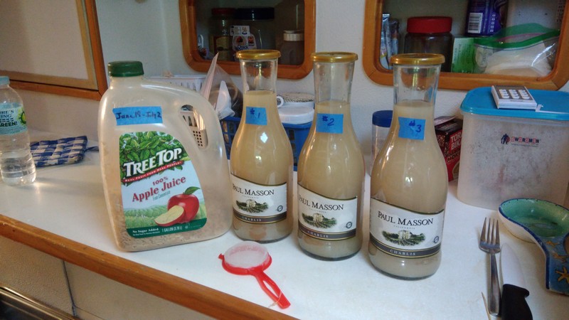
When it came to "siphoning off" to bottles, I did that one time with a proper siphon hose and decided that was too much trouble. I ended up just pouring my 2-week-old fermented rice wine from the gallon jug into the "clarifying" bottles, gently, using a funnel, and leaving the sludge in the bottom of the jug. I did filter what I poured off through a fine-mesh plastic filter (a plastic filter, a little cotton cloth, or a paper coffee filter might work also). What I used is the red "filter" in the foreground in the picture. I labeled my clarifying bottles 1, 2, 3 because the first one was easier to keep the sludge out than the last one. The #1 clarifying bottle generally had a little less "sediment" in it, and took less time to clear up. (In the end, for a thirsty person, it didn't matter).

Once the very fine sediment falls to the bottom of the clarifying bottle, the wine looks clear, and looks very much like white wine. Then siphon or pour gently off to your serving bottles. It takes at least 3-4 days for the stuff to settle to the bottom of the clarifying bottles, and the milky wine to turn clear. But if desperate, you don't have to wait that long! Chill well, and it's a decent substitute for that evening glass of white wine.

I have found that I have quite a bit of left over rice in the gallon jug. I tried re-using the rice (just adding a little more), but the brew ended up too sweet for some reason, so now I throw out the used rice and start new.

It was totally drinkable, and certainly better than paying $25/bottle for terrible wine. I sometimes use it to stretch my existing (cheap boxed) wine by mixing half and half.

Once I ran out of the wine I brought with me, I started making a 1 gallon jug every week or two. By the time I decanted it the gallon jug into "clarifying bottles", this turned into three 1 liter Paul Masson clarifying bottles. Once decanted to 750 ml "serving bottles" (leaving sludge in the bottom), it would make about 4 standard 750 ml wine bottles. With 2 1-gallon Jugs, and 3-4 Paul Masson bottles, I always had enough to share with my (also desperate) friends.

I never bothered testing the alcohol level--it was a good enough facsimile to wine that I wasn't worried about perfection.

I did use the Betadine method to sterilize the jugs and bottles.

Try it, and see how it works for you!

Thursday, October 30, 2008

Isla Gamez and Isla Parida, Western Panama

Anchorage Positions
Isla Gamez: 08-07.697N 082-19.037W
Pta Jurel: 08-08.347N 082-19.300W

We left the Secas at about 10am. The wind as usual was about 2 knots from the SW, so we motored most of the 20 miles. Toward noon an onshore breeze developed and we were mostly sailing for a little while.

The guidebook mentioned that cruisers favored the Punta Jurel anchorage at Isla Parida. There is a small resort there that welcomed cruisers. So that is where we planned to stop. But on our way in, we passed close to Isla Gamez, and that looked just beautiful.

We went on in to Punta Jurel, and put the anchor down for lunch (we were starving by then). Either the resort is no longer functioning, or it is in sleep mode for rainy season. The beach looked junky (buckets and things scattered about) and not like it was being maintained as a resort. We could see one building in the trees with a guy sitting on the porch, but no other signs of life.

The anchorage itself was OK, but nothing special. So after a quick crew conference, we voted unanimously to go back out and anchor off Isla Gamez (only about a mile away).

This turned out to be a beautiful anchorage--the best so far on the Pacific side of Panama, in our opinion. Nice holding in heavy sand, a gorgeous beach with palm trees ashore, some wind to keep us cool, and very little swell. I could have stayed here for a week or more.

There were a couple of local boats picnicing at the beach on Sunday when we arrived, but they were gone by sundown. We had the whole place to ourselves all day Monday. We swam into the beach and found some coconuts. We burned our trash at low tide on the beach. There is supposed to be good snorkeling here, but again rainy season has rendered the water very cloudy, with only about 8 foot visibility. So we didn't even bother.

We got the usual evening heavy rain, with a little wind. But we were sheltered and secure. A very nice anchorage (this time of year).

Islas Secas, Western Panama

Anchoring Position: 07-59.467N 082-01.812W

We left our spot in the Contreras early in the morning, and motored in mostly calm winds to the Secas.

The guidebook shows about 4 anchorages on the NE side of Isla Cavada. What we found was that the sketch chart is not very accurate as to depths. Each bay with an anchor in it shoaled up rapidly, and we could never get in all the way to the anchor. And the chartlet is just a little off (the features do not all match up). Our raster chart was no more accurate. So we carefully felt our way around and ended up right where our friends on Carina and RDreamz told us to anchor. They also found the other
anchorages too shallow and too confining.

In each bay, we saw one mooring in the exact best spot to anchor. Just inshore of the mooring is where the bottom came up fast. So pick a spot just outside of the mooring.

The northern anchorage, where we ended up, is off a pretty little sand beach with palm trees. We anchored near a rocky pile (we could see it on the depth sounder and just barely make it out from deck). Dave managed to pick out a nice sand spot in 20' of water. The anchorage was passable in the mild conditions we are experiencing... a little rolly, but not too bad.

In the morning I snorkeled the whole area, and did find some live coral and tropical fish just inshore of us, but the water was disappointingly murky. Friends passing thru here a few years ago mentioned snorkeling and finding clear water here even during rainy season. But not for us this time.

We also did a little gunkholing in the dinghy. The resort here looks deserted. We met one caretaker fishing off the floating dock in the southernmost bay. He said the resort is closed until December 15.

We spent all Saturday here, and expected to be inundated with weekenders by Saturday afternoon. We did see 2-3 small sport fishing boats trolling around the island, and 2 of them anchored overnight, but away from us. They were gone at first light.

Punta Balsa, Last Stop in Panama

Anchorage Position: 08-04.610N 082-50.967W

The jump from Isla Gamez to Golfito is about a hundred miles... too far to make in one day. Friends had told us of a passable overnight anchorage at Punta Balsa, on the east side of the Burica Peninsula, on the very western edge of Panama.

It's 35 miles from Isla Gamez to Punta Balsa, so we left in the early morning, motoring north around Isla Parida. Again, virtually no wind. In heavier conditions, the way north and west around Parida might be risky due to relatively shallow water (15' deep). Some of these areas would break in heavy seas. Even though we've had less than 10 knots for nearly a week now, there is still a 6-8' long Pacific swell.

We have not been 'off soundings' in so long that Dave thought our depth sounder wasn't working. But the area between the islands in the Bay of Chiriqui (where we've been for the last week) and the Burica Peninsula gets very deep--1500 feet deep.

We were only about a mile off the waypoint we'd been given before we finally 'found the bottom' at 500 feet. It still didn't look like we'd find any protection from the considerable swell rolling in. But we kept on going in.

The bottom came up rapidly, but was still at 80 feet a hundred yards from the waypoint. We went in very slowly and finally, we found the little pinnacle... it shallowed up to about 20'. We motored around in a cloverleaf to make sure we had plenty of swinging room (the tidal range is still about 10' here). We finally dropped anchor in about 25' at half tide. The swell had dropped off in the last quarter mile, due to shoals that extend from the point just south of us. We could see heavy breakers
for quite a ways out from shore.

During the night the conditions changed from 'really rolly' to 'not bad', as the current and wind changed. The current runs along the shore and reverses with the tide. For about 6 hours during the night, with no wind, the current held us beam to the swell, and we rolled like heck. But the wind was zero and we knew we were stuck well to the bottom, so it wasn't dangerous, just uncomfortable.

We have only seen one other cruising boat during this whole trip, and only a couple fishing boats. We are in the 'skip zone' for the Panama Pacific net, so we can't hear the friends we just left in Panama.

We are looking forward to getting in to Golfito, where there is a fully protected anchorage, and reportedly a small cruising community.

Saturday, October 25, 2008

Life in the ITCZ

For the last 2 days, it has been pouring rain.

On our last night in Bahia Honda, the heavens just opened up, and it poured all night long. The first hour of pouring rain is nice... it fills the water tank, washes the salt off the boat, etc. The next day, we left Bahia Honda in the rain, and sailed in the rain, and then it poured all night long again. Yesterday, it only threatened most of the day, but everywhere we looked were low black clouds. After 3 days of it, we are shouting ENOUGH!!!

Taking a close look at the weather map (http://weather.noaa.gov/pub/fax/PYEB11.TIF), I see that the Inter Tropical Convergence Zone has been sitting right over top of us again. Hopefully it will move a little south or a little north and leave us alone.

I see a gleam of sunshine in the Eastern sky this morning. The low black clouds that have surrounded us for the past 3 days have broken up some. Hopefully we'll get a sunny day today. (and by 11am, we'll probably be complaining about how hot it is! :) But we sure need a day of dry weather to chase the damp away.

Islas Contreras, Western Panama

Anchoring position in the Contreras: 07-51.964N 81-47.635W

We totally skipped Isla Coiba, which is no longer a penal colony and is now a national park. Until recently, there was a reasonable fee to stay for a day or two (something on the order of $10-$20 per night). But cruisers who arrived in Panama City just before we left said that they were asked for $100/day to stay there. ($20 pp per night, and $60 for the boat for the first night, and $40 for subsequent nights).

We wanted to go check it out for ourselves, to see if it really was that outrageous. But we're getting short on time and we just decided we'd skip it. I wanted to go, confirm the fee, and leave immediately (in protest) to make a point. But it seemed a little ridiculous to go to that extent (it's 2 hours motoring to get there, and 2 hours to get anywhere else).

So we went directly from Bahia Honda to the Contreras, going around the south and west end of Isla Medidor. (Someone had warned us not to go through the narrow slot between Medidor and the mainland, saying the currents and waves were nuts there).

We found a nice anchorage in the deep bay on the north side of Isla Brincanco, approximately where the Bauhaus guide indicates. The sketch chart, when used with the GPS and Sea Clear to plot the boat on the chart, isn't exactly accurate. But it is accurate from a visual standpoint. The best anchorage IS west of the prominent rocks, but the location that that plots in Sea Clear on the sketch chart is just EAST of the rocks.

We didn't get to do any exploring, because it started raining soon after we dropped anchor, and poured all night long. There were 2 fishing boats that came in late in the day and anchored in the NW corner of the bay. They were gone at dawn.

This island group is supposedly part of Coiba National Park, and we'd been warned by others that we might get asked to pay a fee to stay there. Our strategy was to resist paying and cite weather and just an overnight stop. With the dinghy up on deck, it's not too hard to argue that we didn't plan to go ashore. But the weather was so nasty that I think all the patrol boats wisely stayed in port. We never saw a soul. There is nothing that we could see ashore... one small beach and 2 palm trees,
and then heavy vegetation everywhere else.

Wednesday, October 22, 2008

The Beautiful Bahia Honda in Western Pacific Panama

Anchorage Position: 07-45.124N 081-32.800W

The comments we heard about this bay seemed unanimously wonderful. The West Coasties all said "Better even than Bahia Santa Elena in Costa Rica." Since we haven't been to Bahia Santa Elena yet, we couldn't relate. However, our own reaction is WOW!

After nearly 2 weeks of rockin and rollin at the Flamenco anchorage in Balboa, and then 4 days of tenuous rolly anchorages, this is REALLY NICE.

Bahia Honda is a really deep bay where you can get total protection from the swell and the wind. And amazingly, it is very sparsely developed and so our anchorage feels very remote. We heard a waterfall ashore after the rain last night, and howler monkeys and various birds, too.

We are the only cruising boat here. We've only seen one other boat in the last 5 days of traveling, and they were headed the other way. From listening to the SSB nets, it seems nobody moves anywhere in the Panama/Costa Rica area this time of year.

We left Isla Cebaco about 10am yesterday, and headed NNW toward the coast. We wanted to sightsee the coast a little on our way to Bahia Honda. It is a beautiful and wild coast. Not much in the way of habitations evident here. Our Panama road map doesn't show any roads in this area. And there is no cell phone service at all.

We did check out Puerto Escondido, the next bay to the SE of here. Tao 8 told us it was a very nice anchorage. It did look nice, but we are glad we carried on to Bahia Honda. Puerto Escondido is a typical semi-exposed swelly anchorage compared to here.

Soon after we dropped anchor, we were visited by Domingo, a talkative old guy in a cayuca. We had heard about Domingo from other cruisers... He and his family live across the bay on a finca (farm) and he can supply some fresh veggies, and also can hustle gas, diesel, and 'dry goods' from the town.

Domingo talked a mile a minute in Spanish, and we only half followed everything he said. But he did invite us over to his house, we will probably go for a visit this afternoon. He mentioned there were children there and suggested we could bring some cookies and maybe school supplies for the kids. Later we were also visited by one of Domingo's sons, Kennedy. He was looking for fishing line and lures. His opening line was "You have a very nice boat, mucho dinero". Dave told him he would look
and see if there is something he could spare. I don't think we should just give stuff to anyone who asks. But it's hard to say no sometimes, when we have so much and they have so little.

Cruising Details

We had all 3 chart programs (SeaClear with the Bauhaus chartlets, Nobeltec with Raster charts, and MaxSea with older CMap charts) up and recording our trail as we came in. The Bauhaus chart is still the most accurate, except we found at least one shoal (5' or less at mid tide) where he has a 6 meter sounding. CMap and the Raster charts seem to agree with each other pretty well and are both off positionally by about .2 miles. Our raster chart says it is WGS72.

In the Bauhaus Guide it is the '6' (meter) depth indication, due north of the eastern edge of Punta Miel and SSW of Isla Levin. (on our raster chart, which has depths in fathoms, it's where the 3 1/4 spot is).

It's at 07-45.096N 081-32.515W. We were exploring at low-rising tide (about +2 feet according to our tide chart) and trying to find an anchoring spot in one of the bays as you come in, on the west side. We could see the one spot that is noted with 1 meter indications in the first bay, and went around that and into the blue area on the north side of the first bay. By the time we got to reasonable anchoring depths there, that seemed to too confined to anchor in. So we carried on around the point
to the north of it, outside the blue shading, to go into the next bay. We were RIGHT OVER the 6 meter depth indicator when the depths went from 30' - 15' - 5' in one boat length. I am not sure we touched, but we backed right out of there, nosed out a little further and tried again, and got the same. So then we went way around the point.

We ended up a tiny bit east of the 14 and 10 meter spots in the westernmost bay, at 07-45.124 and 81-32.800W. There is a narrow shelf here that is anchorable depths, a small beach at low tide, and waterfall we can hear ashore to the south of us. A little wind comes over the low spot in the hills to the SW. There are no obvious habitations in this bay, but we did see some guys get dropped off by lancha in the low spot to the SW...not sure where they are going, except maybe to hike across the low
spot for a lancha to Isla Medidor, where we have heard there are some very large foreign residences under construction.

Monday, October 20, 2008

Finally in Western Panama

After 2 more long days of motor sailing westward, we are finally in the area known as 'Western Panama'.

In the last blog post, we had just rounded Punta Mala. We actually turned the motor off and did some sailing that morning. However, soon after we finally shut the motor down, true to form, the wind went light and on our nose about an hour later, so we had to turn the motor back on. I think I need to add 'miles actually sailed without motor' to my monthly progress log!

As I keep telling Dave, we'd actually sail more if we weren't trying to go everywhere and do everything.

So picking up from yesterday's blog... the destination yesterday was Benao or Punta Guanico, about 10 miles apart just a little west of Punta Mala. Benao is open to the southwest, where both the wind and waves are coming from this time of year, so we weren't sure it would be a good anchorage. But friends had said you could tuck up way in and it's OK in mild weather.

We got to Benao about noon, and went in to have a look. Conditions were probably about as settled as you'd ever get during rainy season along that coast. Where the Bauhaus guide had an anchor didn't look that good... too exposed to the SW winds and southerly swell. But on the west end of the bay, there was a spot where one or two boats could anchor up and be a little more out of the wind/swell. (Approx 07-25.675N 80-12.205W) The bottom looked OK on the fish finder. But we did not stop. We wanted
to go a little further so our next day wasn't so long.

So we carried on to the Punta Guanico anchorage, about 10 miles further west. We stayed close in to sightsee along the coast. (watch out for fish buoys crossing the bay, but I think they are long lines, not nets).

Approaching the spot where both guide books said there was an anchorage, it didn't look very calm. But we crept in closer and motored up and down the coast a little, and found a fairly nice spot that seemed tranquil. (07-19.709N 80-20.773W) Since the tidal range is 'only' 10 feet here, we anchored in about 15' deep at mid tide. The bottom was very good holding.

We heard howler monkeys in the trees in the late afternoon. We could see the town further north in the bay, and hear music coming from a cantina (it was Saturday night), but weren't really interested in going in. A open fishing boat passed us in the early evening, going out to fish for the night. We saw 3 lights out near the point all night long, and they were still there when we left in the morning.

I found out later that the long low island to the north of our anchorage (Isla Cana) is home to one of the most prolific nesting grounds for the Ridley sea turtle, and it is nesting season. It would have been nice to have explored a little, but we are running out of time, and didn't want to lose this weather window to finish the most difficult part of the passage.

The next morning, we again got up at 5am and motored out and headed westward again. The Guanico anchorage had turned out to be very peaceful. But during dry season, with northerly winds, Benao might have been a better choice.

On our passage from Guanico around Punta Mariato we experienced the worst of the current-against-wind conditions that people told us to expect along this coast. We had a 1-2 knot following (westbound current) and light westerly winds and a large SW swell. The current made the waves very steep and close together. We buried the bow several times, even though the wind was only blowing about 5 knots. The worst part was the last 10 miles approaching Punta Mariato.

With the following current (and the motor on) we made very good time and rounded Punta Mariato around noon. Though our original plan was to head for Ensenada Naranjo for the night (#4 on our chart), we decided we had time to check out that anchorage and go all the way on to Isla Cebaco. So we stayed in close around the point, and went up through the slot between Isla Roncador and the mainland (in a heavy rain shower) and poked our nose into Naranjo. Again, it looked like, under the current conditions
(light SW winds and mild southerly swell), it would be an OK overnight stop. The swell does find its way in there, but gently so, and it looked like a good bottom for anchoring. Anchor spot approx 07-16.437N 80-55.510W

Then we carried on NW to Isla Cebaco, the SW corner, to an anchorage also called Ensenada Naranja (note that this Naranja ends in 'a' and the other one in 'o'). I did not number this one on our chartlet, but it is roughly due south of spot #5.

We had some decent sailing winds the last 2 hours, but since we'd decided to push on all the way to Cebaco, we had to keep the motor on to keep the speed up, so we could make the anchorage before dark. It looked like, in the SW conditions, that the traditional anchorage in the SE corner of the bay would be totally exposed, so we needed time to try to find a good anchoring spot.

We first went to the west side of the bay to look at what appeared to be on the chart, an anchorable spot with more protection. But it is not a designated anchoring spot in either guide book. And we agreed. It just looked too small to us, and maybe rocky on the bottom. Not near as anchorable as it appeared on the chart. It might be worth trying if you had more time to fool around.

So then went to where both guidebooks had the anchor, on the east side of the bay. We found some protection from the swell, but, as it appears on the chart, it is pretty much totally open to the southwest. We found about 6 moorings around the spot where the guidebook shows the anchor. Carina had told us that during the winter months, there is a fuel barge stationed in this part of the bay, and it's a popular stop for the sport fishing boats to get fuel and overnight on their way from Costa Rica
to Panama. Carina hadn't mentioned the moorings, though. But the fuel barge doesn't arrive until the winds change to a northerly quadrant, when the bay is well protected. Now, no barge, and all the moorings are empty--we were the only ones in the bay.

We poked around and found a bit of room shoreward of the moorings. The bottom is good sand and the anchor hooked up smartly. The light SW wind, blowing right into the cove, at least held us into the swell (until it dropped and went NW after dark). Since the wind dropped, we have been drifting around all night in essentially no wind, sometimes beam-on to the swell. But after the 3rd day of 'up a dawn, going all day', we were pretty exhausted, and slept pretty well in spite of the roll.

Our anchoring position is 07-29.528N 81-13.329W.

Note that on our Raster chart, this point shows as slightly inland. This chart is an old one, with WGS-72 as the datum. There may be a newer version of this chart that plots correctly, but be cautious.

Chart Name: M21582S0 - Bahia Montijo
Source Scale: 1:45000
Horizontal Datum: WGS-72

Just before dark, a Canadian boat named Tao 8 sailed into the anchorage and dropped nearby. We chatted with Larry for awhile, swapping experiences in anchorages. They are on their way from Golfito to Panama City.

Sunday, October 19, 2008

Safely Around Punta Mala

We are currently under sail, having rounded the dreaded Punta Mala only a half mile offshore.

Our departure from the Flamenco anchorage near Panama City 2 days ago was really hairy. In the morning the winds were light and it seemed time to go. But by the time we'd loaded the dinghy on deck and got ready, the winds had picked up again to about 15 knots right on our nose. Plus we had some current going against the wind, so the first hour was really unpleasant. At one point we were only making about 2.5 knots. I almost talked Dave into anchoring overnight at Taboga. But we pressed on another 15 miles to Punta Chame. #1 on the map below.

By the time we arrived at Punta Chame at about 5pm, the wind and seas had calmed considerably, and our trip had not been unpleasant.

We tried to pick an anchorage as far in as possible, but away from the very small town on the point. We came in at high tide on a 17' tide, and while Dave was fooling with the anchor, we edged in to water that was only 13' deep. At low tide we would have been high and dry there! Needless to say, we went back out to deeper water.

We finally anchored at 08-38.794N 079-42.896W, in what would be about 15 feet of water at MLW. The anchorage was mostly tranquil in SW winds about 10 knots... at least until the current changed. With a 17' tidal range, the current rips in and out. In the middle of the night we were hanging dead stern to a 15 knot wind. Early in the morning, when the tide changed again, it got choppy enough to be banging us around. We finally gave up trying to sleep at about 4:45am and got underway.

Coastal Panama at Sunrise

The Captain Naps

The day dawned bright and sunny, and the winds dropped to nothing. We motor sailed the whole way, mostly with some current behind us. (there is a big eddy from the Humboldt Current that runs counter clockwise around the Bay of Panama). It was a beautiful day and we saw turtles, some very frisky small black spotted porpoises, whales, and jumping fish, as we sailed along.


We had sweated making the 70 mile trip from Chame to Punta Purio and arriving with enough light left to pick a good anchorage. But we left early, made good time, and arrived at Punta Purio about 5pm. (Sunset here is about 6pm)

Punta Purio is #2 on the map below. (Click to see a larger version)


We anchored at Punta Purio at 07-39.312N and 80-03.759W, in about 12' MLW. By this time, amazingly, the wind was SE. We had seen this predicted on the GRIB files and thought it was bogus, but sure enough, we had SE wind until about midnight, when it turned W. Again we had a tranquilo anchorage until the turn of the tide near dawn. We are not sure what's up with that particular tide turn, but again it was choppy enough to wake us up early.

We had nice winds when we woke up this morning... 5-10 knots from the NW. Leaving the anchorage, we angled out to get a look at Isla Iguana (another possible anchorage). There were an amazing number of frigate birds circling the island as we motored past. Probably a nesting ground. It didn't look like a very good anchorage.


We put out the sails, and combined with the prodigious southbound current, we were clocking about 9-9.5 knots for awhile.

Our Navigation Screen Showing 9.1 Knots

We rounded Punta Mala about 9am with still light WNW winds and about 6" seas (with of course the ever-present large slow southerly swell underneath). Because the conditions are so tranquil, we stayed in close to sightsee. We were about a half mile offshore in 60' of water. There is something like a Coast Guard station at the point...a lighthouse and several fairly large buildings.

Thursday, October 16, 2008

Cruising toward Costa Rica


Looks like the wind has laid down, so we plan to set out today for a 2 week cruise north and westward to Costa Rica. We hope to be in Costa Rica around Nov 1.

Above, for your viewing pleasure, is a simple map of the area we will cover, and most of our planned anchorages. Click on the image if you want to see a larger copy.

You can follow our actual progress with this link. Soggy Paws Position

Wednesday, October 15, 2008

Soggy Paws has Eyebrows


Sitting here waiting for weather, with the sewing machine newly tuned up, has been a great opportunity to work on sewing projects.

The latest project is 'eyebrows' for the dodger.

We have 2 big awnings that cover the whole boat. One goes from the mast to the forestay, and the other goes from the mast back to the arch in the back. However, we rarely put them up because (a) it's a big production to haul out and put up and (b) we never know when we'll get slammed with a thunderstorm and gusts to 40 knots. But having a little sun protection, especially just in front of the dodger and over the main cabin area, would be a good thing.

So we sketched up a design for what Dave calls 'eyebrows'. A relatively short, flat sunbrella awning that we can leave up in fairly substantial winds. I made it in 2 pieces (one strip for either side of the mast). They fasten to the hard dodger top on the outboard side (just grommets and line), and fasten together under the boom at the back, and go forward to shrouds outboard of the mast. They turned out pretty good and we're congratulating ourselves on a good design... something that's easy to put up and leave up in most weather, and gives us some sun protection and some rain protetion.

Still Sitting in Panama City

Yep, here we are again 'waiting for weather'.

We finally got all our critical repairs done by last Saturday. Now we've been waiting out an unusual bout of high winds, I think caused by tropical activity in the Western Caribbean. Gosh I miss Chris Parker.

However, I am finally accumulating enough weather links to feel like I have all the weather available to me as a layperson. And starting to feel like I know what is 'normal weather'.

We think we have a window to get around Punta Mala (Bad Point in Spanish) coming up on Saturday/Sunday. So we plan to leave here tomorrow and make 2 day-hops to get positioned for a rounding of Punta Mala on Saturday. All the anchorages we've selected are kind of iffy... open roadsteads that should be protected enough for a rolly overnight anchorage. But we're not sure. The guidebooks don't cover this part of the coast (from Panama City direct to Punta Mala) because, coming in the other direction,
the advice is to go via the Las Perlas islands, to totally avoid rounding Punta Mala at all. But that doesn't make sense for us, because it would add about 90 miles to our windward journey.

So if we get to one of our selected anchorages and it is totally untenable, we'll just have to gut it out, keep going, or go back.

The good news is that it has been mostly sunny and cooler here the last few days. The winds have been really gusty in the 15-20 range. It's a nice change from hot, humid, rainy, and zero wind. It kinda feels like fall.

Friday, October 10, 2008

The Saga of the Sputtering Tohatsu - Part 3

We finally did resolve the issue with our 15 HP Tohatsu.

After taking apart and cleaning the carbuerator 4 times over the last year, it did turn out to be the carb.

We took the motor to the Tohatsu dealer here in Panama, and they did a full workover of the motor. They found a couple of minor things. But when they brought it back for a test drive, it still didn't work any better.

The mechanic had insightfully brought a new carbuerator, just in case. When he swapped it out, the motor worked perfectly. They said that sometimes the carb just gets boogered up.

So it cost us the price of a new carb, and some labor, but it's now performing properly. We have the old carb to keep as a spare. Dave wants to try to rehabilitate it some day when he has nothing better to do.

Back in Panama City

Well, we're back here in Panama City.

After about 3 days of enjoying the extra amps our new generator gives us, the battery charger in our Heart Freedom 20 Inverter/Charger went out.

Dave spent a day in the Pedro Gonzales anchorage troubleshooting things. We borrowed another Honda genset from a friend and made sure it wasn't the generator. Then we called Xantrex (the new owners of Heart) and got some troubleshooting advice. When Dave exhausted everything we could think of, we headed back to Panama City to see if we could hook up with the Xantrex Authorized Dealer.

Well, it turned out that the Xantrex rep is in David, the second largest city in Panama, and a 4 hour bus ride away. So we opted to instead take it to a local well-recommended electronics shop. (Electronica Ancon in Balboa, near the YMCA). They took it apart and did component level testing, and found a couple of relays that seemed to be burned. They replaced the relays and it seems to be working. Dave will install it this morning and check it out. Whew! I hope it works.

Meanwhile, we've taken our sewing machine to the local Singer place. We're supposed to go back to pick it up today, with a handful of Sunbrella and the normal thread we use, so he an do a final tuning on it.

Unfortunately, while screwing around in Panama City, we may have missed a very good weather window to go west. The wind came out of the NE yesterday, for the first time. And it's supposed to stay that way for today, and then switch back to SW and blow like stink for a week. :P

I can't quite figure out what weather features are creating the big wind, other than maybe the 2 hurricanes off the coast of Central America, much further north than here. My grib files only go out 6 days, and I don't see any letup in the 20kt SW wind. Bleah!! The highs and lows move around but the wind doesn't seem to change.

We haven't found a 'Chris Parker equivalent' over here in the Pacific, to help us learn how to read the weather patterns. There's a guy that forecasts further up north, but not really down here.

Wednesday, October 8, 2008

Mileage Update

So Far in 2008:            Miles: 2,514   Engine Hrs: 441
Since May 25, 2007:   Miles: 3,750   Engine Hrs: 616

Total Nights: May 25 - Oct 8: 499
- On Passage:          11
- On Anchor:          206
- On a Mooring:         4
- In a Marina:        278
   - Inland Travel:    63
   - In the U.S.:        50

Thursday, October 2, 2008

Hanging out in Pedro Gonzales

We left Balboa on Saturday and have been hanging out at Isla Pedro Gonzales in the Las Perlas islands of Panama.

When we got here on Saturday, in this normally quiet beautiful anchorage, we anchored in the middle of a 'weigh in' and sponsors party associated with a fishing tournament. We found 3 sailboats and literally 50 fishing yachts in the anchorage. There was a canopy with tables and chairs and a band on the beach. Lanchas were running back and forth carrying people into the party. They didn't invite us.

The cruisers gathered on another cruising boat, RDreamz, to watch the fun. Fortunately Phil and Leslie on Carina had been thru one of these before, and said that most of the boats do not spend the night. True to form, all but about 6 boats left soon after dark.

We've been doing 'boat projects' and socializing with the other cruising boats. A couple of boats have just arrived from western Panama (and before that, Costa Rica).

So we've had a couple of happy hours, a trash burn on the beach, and a potluck on the beach.

Above: Philip & Leslie from s/v Carina


Dave got our dinghy wheels mounted. They are huge but effective. Thanks to Jim Yates for lugging them down in his luggage!

You need them here because the 15-foot tide create very looooong beaches for dragging the dinghy up and down.

We have commissioned our new Honda EU2000i generator. It is a quiet, light, but very effective gasoline generator. We were able to buy one here in Panama through Marine Warehouse for $1100 (you can buy them in the States for about $875 delivered). It is the size and weight of our sewing machine, so it is easy to move around, and store it down below when we're on the move.

Dave made a plug that goes from the generator 110v outlet to our normal 30amp 110v shore power plug. Our Link 2000 has a way to limit the load that the battery charger draws (Power Sharing = 10amps) so we don't overload the generator. With this on, it starts out with a 60amp DC charge and then does the normal step down as the batteries come up.

Though Dave is an avowed solar power nut, we have found that trying to live on 100% solar power during rainy season near the equator isn't cutting it. We have 2-3 day stretches where we aren't getting enough sun to keep up. So we will use the generator to fill in the gaps and save wear on the engine. So far we're really liking it.

Our Outback solar controller showing 30amps going into the battery, late morning on a sunny day.

We ran a new halyard for our Code Zero sail yesterday, and Dave wanted to route it inside the mast on the way down. So he spent yesterday cutting a hole in the mast to let it out.

We've spent some time swapping cruising info with the boats headed into the Caribbean, and info on Panama and Golfito, Coasta Rica for us. Both Carina and RDreamz are headed into the Pacific this season, so we've also spent some time swapping info with them.

I have also been working on understanding the Pacific weather products, so we can figure out weather windows. Unfortunately, it sounds like getting to Costa Rica from here is going to be another nearly upwind and maybe upcurrent slog for 400 miles. Fortunately it's light air season, and we don't have to do it all in one jump.

Friday, September 26, 2008

Canal Recaps & Pics Posted

I have put a couple of new posts and some pics from our transit, but I sequenced them in order for our historical record. So those of you watching for the latest posts for updates, might miss it.

You can see them all together at this link: Panama Canal

Wednesday, September 24, 2008

The Flamenco Anchorage, Balboa, Panama


We stopped in here for a few days to let off passengers and pick up a few things before we start moving NW toward Golfito, Costa Rica.

The favored anchorage seems to change depending on the season, as the prevailing winds change.

For the rainy season, the anchorage is on the east side of the causeway that the Balboa Yacht Club is on the west side of, at the Pacific entry to the Panama Canal. As shown by the anchor in the Bauhaus guide, you tuck up on the north side of the Flamenco Marina area.

The only dinghy dock is at Flamenco Marina, and they charge $5.25 per day, somewhat loosely enforced (ie you definitely have to pay on your first visit, but they're not super strict about checking your receipt all the time. Some cruisers told us you could get by paying a few days at a time, and then skipping a few days). The dock is a nice floating dock and very secure.

View of Dinghy Dock & Fuel Dock

There is supposedly a $5/bag trash fee, but we have yet to be asked for it when we have dropped trash off. That may only be for boats getting rid of trash without paying for the dinghy dock.

There is a water hose at the dinghy dock, so you can fill jugs in the dinghy. Right now the dinghy area is at the far end of the fuel dock (in and to the left). There is a blue rope that designates the dinghy area, though even now in the low season, there's not enough room there for all the dinghies.

The Typical Clientele at the Docks

Note: Though the sign says Flamenco Marina, the official name according to the receipt we got is the Fuerte Amador Resort & Marina. Dockage is available at $1.65/foot short term and $1.50/foot long term.

The first time we anchored, we anchored south of where the Bauhaus guide showed, closer to the actual marina breakwater. This was fine for a day or so when the wind was very light. But when the wind came up just a little (10-12 knots), it got very rolly there. So we moved a quarter mile north to where Bauhaus shows the anchor. It is further from the dinghy dock, but much less rolly here. There is a large area, good holding, with about 10-15 feet at low tide.

Internet access: I can see the marina wifi out on the hook with my good wifi setup, at our first anchorage near the marina. But couldn't get anything free/open out there. The only usable hookup was the Flamenco Marina hotspot (nice strong signal), but when hooked up, you get a logon screen. When I asked at the marina about a logon, we were told that the marina internet connection is terrible, so don't bother paying for it. There is free wifi at the Flamenco Cafe and at Bennigans, both right at the marina. It is slow... probably the same feed that you have to pay for on the marina's wifi. I have not pursued a faster alternative ashore.

When we moved further down to the regular anchorage, I started picking up the Whisper hotspot. This is a 'for pay' hotspot, and you can buy 2 hrs for $5, or 15 hrs for $20. At $1.25/hr for reasonably fast wifi on the boat, I think it's a good value. (Dave said "Twenty dollars!!") You can sign up on their website with a credit card, or call the number on the webpage, or find a physical outlet (the shops/restaurants ashore in the shopping center, probably... we haven't been there). I just used my credit card. So far haven't regretted it, though it is probably a little bit risky over an unsecured wireless link.

There is fuel at the Flamenco Marina. It is way cheaper than it was at PCYC in Colon, and a little cheaper than BYC. It does a huge volume with the sportsfishing boats, so the fuel is very good.

There is a mini-mart at the marina, across from the office. It has basic stuff you'd expect at a marina-based mini-mart (no veggies).

There are taxis hanging out at the marina parking lot. We met one who was very nice, with a/c taxi, speaks english. Ramon's cell is 6452-7157. It's $30 to the international airport. Ramon will do 'by the hour' taxi $10/hour and he knows most of the places that the cruisers want to go.

There are buses that stop at the marina but as yet do not have any experience taking them yet. We understand that the route here either ends near the Albrook Mall or at Centro Commercial.

Saturday, September 20, 2008

The Pearl Diving Submarine in the Perlas Islands


Yesterday, on our way around the east coast of Isla del Rey, we went to see what the locals call 'the Japanese Submarine', on the north coast of Isla San Telmo (St. Elmo).

Though everyone, including the cruising guides, refer to it as 'the Japanese submarine', we understand that it is really a 1860's pearl-diving submarine.

A marine archaeologist friend of Dave's by the name of Jim Delgado was here in 2001 and thought it didn't look very Japanese-like. He was very familiar with Japanese sub construction after spending years in the Pacific documenting Pacific WWII ship wrecks.

After encountering the sub on the beach while on vacation, he researched it some more and after spending time here again in 2002 and 2004 with several friends, including Larry Murphy formerly of the National Park Service, he eventually established that it was a "lost" pearl-diving submarine, 'Sub Marine Explorer', built by a German engineer in 1865. It is one of only 5 surviving submarines built before 1870. Read about the find here. Jim Delgado, the archaeologist, is a former historian with the US National Park Service, and is now the director of the Vancouver BC Maritime Museum. He and Dave worked together in the Pacific in the late 1980s, documenting Japanese wrecks.

To sum up the history of the Sub Marine Explorer... a German engineer, Julius Kroehl, built the sub in 1865 to do pearl diving in the Las Perlas islands. But they didn't know about 'the bends'... a problem that occurs when breathing compressed air at deep depths and then surfacing without properly decompressing. The boat arrived in Panama in Dec 1866 and did make several successful pearl dives to deep depths, but by Sep 1867 the engineer and all the sub operators died of 'the bends'. The next/last documented attempt to use the sub occurred in August 1869 when over a period of 11 days it recovered $2K worth of pearls (a LOT of money in those days). But again, soon after, all its crew died of the bends. The sub was then was abandoned, apparently beached on San Telmo and left for good.

The Bauhaus Panama guide book mentioned the sub, but only that it was a Japanese sub on the north side of San Telmo. So we got on the VHF and got a waypoint from s/v Carina. Our Tides & Currents 3.0 program seems to be pretty accurate, and it indicated that low tide was about noon. So we set out from the Punta Cocos anchorage (S end of Isla del Rey) and arrived right about noon.


The sub was clearly visible on the beach at low tide, but would be covered at high tide. It was shaped like a fat cigar and is pretty large. I am amazed at how well-preserved it is after sitting in salt water for 150 years. We took a zillion pictures and will post some here as soon as we get internet.

Sub position: 08-16.896N 078-50.743W
Our anchorage: 08-17.050N 078-50.801W (day anchorage only, in settled weather)

There is an uncharted rock/reef outside/north our anchored position that was visible at low tide at APPROX 08-17.136N 078-50.815

On a settled day with a fast dinghy, you could also dinghy to see the sub from the Punta Cocos anchorage.

Friday, September 19, 2008

Whale Ho!!!

Our First Whale Tail! (Jim Yates)

We are really excited to be in whale territory. We have had numerous sightings so far of huge humpbacks, though we don't have a great picture to post yet.

Once when we were sailing, we sighted a whale about 200 yards directly in front of us. Dave was worried about colliding with it, but it sank out of sight before we got close. You could see the swirls in the water where he had flipped his tail when we went over the spot.

One night, in the Isla Pedro Gonzales southeast anchorage, they were playing in the swirl of current going by the point. Doing what we called 'Tail Flops'. They stand on their head and whack their tail back and forth on the surface of the water. Very impressive. No pics of this, as it was at night (but enough moonlight to see that it was whale tails making the smacking sounds).

On our final night in the Perlas, we were anchored on the north side of Isla Contadora, and were treated to a show by a couple of whales going by the anchorage.

A Humpback Whale Breeches Nearby (Dave McCampbell)