Thursday, July 26, 2007

A Day in the Life on the Rio

0630: It starts getting daylight around here about 0530. So it is pretty light by 0615, and I'm usually up in the cockpit on the computer and drinking coffee by 0630.

0730: The morning VHF net cranks up on Ch 69 at 0730. Dave is usually still snoozing, so I turn up the cockpit VHF real loud and open the hatch to the aft cabin. There are announcements about a Spanish Class, a CPR Class, and 'Information Offered or Needed'. This is where people ask about getting stuff done... varnishing, canvas work, galvanizing, engine repair, etc. After about a week of listening to the net, you know who does what.

0800: Breakfast. We are running out of Granola and haven't found any here. They have Choconuts in the local store, but in a word, "yuck". So we are switching to the local rolls and Dave likes Oatmeal, now that he can microwave it. Once or twice a week we'll do a "big breakfast".

0900: Daily projects. Mine has been laundry for the last few days. At this marina you have to give them your laundry to do, at a cost of about $7 per load. We are fortunate on Soggy Paws to have a washing machine aboard. It is a small plastic unit that lives under the V-Berth. It is designed for remote areas with not much water. You have to manually fill, and manually move the wet stuff into a spinner to finish. But it has a good agitator and a very good spinner. It ain't like home, but it
is also much easier than the bucket method I used on Island Time. The clothes then need to be hung out to dry. It is efficient enough on water and electricity that we can run it out on the hook.

Dave's daily projects are centered on the 6 large Rubbermaid tubs that we brought with us from the States. Unfinished projects. Things like installing a new higher capacity watermaker. We have all the pieces parts to do the job (we hope), just didn't have the time to actually do the installation before we left. One tub was full of 300' of 3/4" 3-strand nylon line. That needed to be stowed for future use, in an area underneath the cabin sole that we didn't have access to. We cut the holes in
the floor just before we left, but didn't take the time to finish them off, clean up the space, and stow the line.

Dave has made me a rather lengthy project list that includes some varnishing, some canvas work, some toerail painting, etc. He is patiently waiting for me to quit screwing around on the computer and get started on my projects!

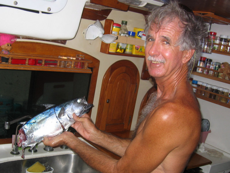
1100: Take a dinghy trip to town. Mornings are preferred for dinghy trips because the wind is calm until about noon. By 3-4 pm it can be quite windy and rough on the river. Dinghying around then is still possible, just a little wetter. A 5-minute fast dinghy ride gets us from the boat to town. There is a pitifully small grocery store and an open air market that includes vegetables and fruit. Nearby is the fish market where you can buy several varieties of fish, shrimp, and crabs. And a meat
market where you can buy fresh chicken, pork, and beef.

1200: Lunch. About half the time we eat sandwiches on the boat, or dinner leftovers. Since restaurant fare here is fairly reasonable ($4-$7 for lunch), we eat out a few times a week. Some restaurants specialize in local food and other in 'gringo food'. We go where the wifi is good. :) If we stay on the boat for lunch, we quite often take a dip in the water to cool of.

1300: By early afternoon the wind is blowing and it's reasonably cool in the cockpit, so I have been alternating between laundry and computer work in the cockpit. Dave has been working down below with the fans on. We turn our A/C off during the day, both as an economy measure and to enjoy the outdoors.

1500: By about 3pm, the sun is low enough in the sky that we are getting shade from the trees off our bow, so it's cool enough on the dock and on the foredeck to move projects out there.

1730: As the sun starts to dip we finish up our current project and get ready for an evening swim. There is a float with a couple of lounge chairs on it, about 100 yards from our stern. So we usually swim out to the float, lounge in the cooling air for a few minutes, and swim back to the boat. Though there are nice showers here, they're kind of hot, so we are still showering on the stern.

1830: As we finish up our shower, the mosquitos start to come out, so we turn on the air, close all the hatches, and go below for dinner. Once dinner is finished, we read or watch a movie. We brought about 100 DVD's with us, about half of which we haven't seen yet, and there's an active loaner system among the boats, so there's always a movie we haven't seen.

A few nights of the week, one of the local marinas does something special. On Friday nights Mario's hosts a local music group for pick'n and grin'n. It's not quite the social swirl that we experienced in Trinidad, mainly because there's less to do ashore, and fewer boats.

Friday, July 20, 2007

Dockside in the Rio Dulce

We pulled into Tortugal Marina yesterday. Almost all the marinas are full, and the late arrivals are scraping the barrel on the lesser marinas. We were really amazed at how many boats are here. There are more boats at Mario's Marina now than were in the whole Rio Dulce when we were here in Island Time in 1997. And about 10 small/medium marinas instead of the 2 that were here then. It is possible to anchor out, but security is an issue (dinghy thefts, etc). Dave wouldn't even consider anchoring
out.

Fortunately we had planned ahead and secured reservations several months ago for us at Tortugal. (we did this by paying dockage ahead for 2 months without being here) Dave said the overflow marina (formerly called Suzannah's) was really hot (no breeze) and 'low rent'. Tortugal is right across from Suzannah's, is well run, has a nice restaurant, and gets the afternoon breeze. It is also one of the few marinas upriver from the town of Fronteras, and so the water here is clean enough to swim in.
The stern of our boat is about 50 yards from the marina's swimming area (complete with float, lounge chairs, and dive platform).

I was dismayed to find that the wifi at Tortugal is not working, and the only wifi I can pick up from here is locked. So that's going to be a pain in the butt. Tortugal's satellite dish got struck by lightning a couple of weeks ago, and the satellite system has been shipped to the US for repair. There is still no phone/DSL in the area, everyone does internet by satellite... and with the advent of cell phones, there is little pressure for the phone company to extend the wires.

I'll have to find a convenient internet cafe. There are several a short dinghy ride away, and one we passed on our walk into town charging Q10/hour ($1.30). A few people at the marina are talking about getting cellular data cards. I told them if they did that, to get me one too. It is a PCMCIA card that uses the cellular system to do internet. In the states a cell data internet card plan is only about $40/mo. One of the guys here said he thought it would only be $30/mo for 'all the data you
can use'. We seem to have good cell reception here (better than in Satellite Beach!)

Though most of the travel around here is done by dinghy, we hiked into town by foot yesterday afternoon, just forthe exercise. It is about a 30 minute walk on a mostly shaded path. (Safe enough in the day, but probably not good at night). We bought a Guatemalan Sim Card for my GSM (Cingular) cell phone, changed some more money, surveyed the grocery store, and bought a few veggies.

Cell Phones: I have a Cingular GSM tri-band phone. When you buy it from Cingular, it is locked to Cingular. You need to get it 'unlocked' before you can use it on any other cell phone system. We had already paid a guy in Belize $20 US to 'unlock' my phone. You can also get this done via eBay, by mailing your phone to someone. Or you can buy an already-unlocked phone on eBay. You need a tri- or quad-band GSM phone to be able to use the phone everywhere in the world. Dave's old dual band Nokia
is good in South/Central America except Costa Rica. So here we paid Q50 for a Guatelmalan sim card and bought Q100 worth of minutes (for a total of $20US), and they said it will cost us about 10-15 cents a minute to call Florida, and about half that for local calls. One of the challenges was dealing with the phone in Spanish. When you insert the Guatemalan sim card, all of the sudden the phone menus were all in Spanish. I finally located the manual for the phone to figure out how to switch it
back to English. Then when we tried to call out, I had trouble with MY phone... it will call and receive, but apparently the microphone is broken (probably a byproduct of the unlocking process).

But I had an unlocking program for Dave's Nokia (program purchased earlier off eBay) and unlocked his phone, popped the sim card in, and voila, phone service. (now if I only had internet!!!) Aparently pay-as-you-go phone cards are the norm now for cruisers, at least in the US and Caribbean. There is no monthly charge, and when you leave a country, you just sell the sim card and leftover minutes to the next boat coming in. (much cheaper than using my Cingular phone service 'roaming' which is about
$2-$3/minute).

Dave got a chance to go off to Puerto Barrios this morning. PB is the major coastal port, a few miles from Livingston. You can get anything in PB. I think Dave was after some R12 refrigerant, but who knows what else he'll come back with. I was left with the cell phone and the dead batteries of a friend's boat who's off in the States. Dave said "I got the battery charger going, the multi-meter's on the dinette, call Ron and he'll tell you what to do. When I checked his batts, they were up from
zero to 7.7 volts, and his freezer's at 45 degrees. Hope the batteries are not destroyed... We're not sure what happened, but at least we were here to handle it.

Gosh it is so nice being around other 'yachties'. It has been nearly 2 months since we've socialized. Being footloose and fancy free is fun for awhile... On this morning's VHF net, there were announcements about Spanish classes, CPR classes, free wifi with lunch (several of the local spots advertised their daily specials). Tomorrow is 'Swap Meet Friday' at Mario's Marina, about a mile downriver. Ah, civilization. (but I'll be darned tired of it in a few weeks).

Wednesday, July 18, 2007

In the Rio Dulce!

Well, we finally made it. An easy trip from Belize, and an easy crossing of the bar. We followed recent waypoints we'd been given and the lowest we saw was about 6 feet at a mid tide.

It took us a couple of hours to get our paperwork done, but the officials were assisted by Raoul, a very pleasant English-speaking agent. They all came and visited the boat, but it was a nice relaxed social hour. An hour later we went ashore, got some Quetzales from the ATM machine on my Space Coast Credit Union ATM card, and picked up our paperwork. The fees were: Q200 for Immigration ($26.67) Q75 for 'le doctore' ($10) Q125 for the Port Captain ($16.67) Q196.88 for Boat Clearance/3 Months ($26.25) and Q153.12 for ?? (we think paper prep and/or lancha). We are good now for 3 months. In 3 months we can get a 3 month extension on our passports and a 9 month extension on the boat.

Livingston is an uncomfortable place to stay for the night (an open roadstead and lots of boat traffic), so we hurried up into the Golfete and stopped at a new place for the night. A friend had told us about Texan Bay Marina but we weren't exactly sure where it was. When we got close, we looked for boats and masts, and very slowly made our way toward them. As we get close, a small lagoon opened up and we could see 4-5 boats at the marina (and some more masts inside).

Once next to the marina, there was another, even smaller lagoon with only 2 boats in it. We anchored next to a Westsail 32. Posn: 16-46.07N 88-49.60W.

What a beautiful place! Completely surrounded by rainforest, with locals in dugouts going by...fishing, on their way to work, etc... birds, etc etc. We are taking pictures of everything, but it will be hard to really portray the beauty in a static photo.

We went ashore and had dinner in the marina restaurant (a little thatched hut). There we had a nice time talking with the first cruisers we've seen in a couple of weeks.

We decided to stay here a day and use the kayaks to explore up the little stream that empties into the lagoon we're in. Being finally in a good anchorage with no expected weather issues, I got a really sound sleep last night and we both slept in til nearly 9am.

Tomorrow we'll head further upriver to Fronteras, where all the boats and marinas are.

Monday, July 16, 2007

Goodbye Belize, Hello Guatemala

We are currently motoring for Punta Gorda, Belize, the southernmost place where there's a town with Customs and Immigration so we can check out of Belize. Punta Gorda doesn't have a protected anchorage, so we anchored in the Mojo Cays last night, and got up early to go Punta Gorda, check out of Belize and then to Livingston, to check into Guatemala.

We haven't been diving in days... between the tropical wave (finally gone) and the fact that the closer we got to mainland Belize the worse the visibility got, we have packed away all our dive gear until we get to the Bay Islands of Honduras, in a few months.

This corner of Belize is very close to big mountains in Guatemala and Honduras. The wind swings well north of east and blows like stink, and then turns to very light out of the south in the middle of the night. We found it challenging last night to find a protected anchorage. Where we first stopped looked fine when the wind was 10 kts, but by 4pm it was up to about 25, so we back-tracked a little and re-anchored in another spot we'd checked out on the way down.

Passing Monkey River Town, Belize

We left Placencia after 2 days there, and are now passing Monkey River Town, headed south. 16-23N 88-24W

Placencia was a very small town...mainly subsists on tourism and the Moorings charter business here. Moorings had about 10 cats and 8 monohulls and a dock. Things look a little slow right now, but I bet the place is hopping in the winter time.

We were able to get a few fresh fruits and veggies in the town vegetable market. and a bag of white flour from the 'super market'. Dave and I took a stroll around town at sunset one evening. There are lots of places to stay... from bunkhouses and a campground to luxury resorts... but not many tourist-looking people.

The best thing about Placencia was the fact that there was wifi (weak) in the harbor. Several of the establishments in town have wifi and we could just barely pick up a usable signal out on the anchor. When we went in to the town dock to get water (about a quarter mile closer to town) I got a really strong signal and was finally able to download all my internet mail (~150 messages!). I kept getting stuck trying to download an 8MB file someone sent me and the link would break...

Dave took me (and my computer) out for dinner Saturday night at the Purple Space Monkey cafe, where they had good local food, cheap rum, and free wifi. We both read our email, checked weather, etc etc. (Didn't get much of a chance to respond to the email, however).

The whole time we were in Placencia, we were under a tropical wave, so it was squally and overcast most of the time. It was also a weekend, and so the town was pretty quiet.

After asking on the net the procedure to check out of Belize for Guatemala, Dave decided it was too expensive and that we should check out at Punta Gorda, a little further south. So we are now headed for Punta Gorda.

Saturday, July 14, 2007

40 Knots at Midnight!

Wahoo! The times that great bar stories are made of...

ALL the weather sources we had said that yesterday was going to be clear, light wind day. So we though it would be a good day to explore one of the 'settled weather' anchorages. Dave was hot to see the Pelican Cays. He had a penciled note in his guidebook that said "good fishing".

We got in about noon, after working our way in to a lagoon area surrounded by drying reefs and small mangrove islands. With a few waypoints acquired earlier from cruising friends, and good light, it was very easy. The only challenge was finding a spot SHALLOW enough to anchor. Depths inside the lagoon were mostly 60-80', with a few spots that were 2'. Sheesh. We explored around quite a bit and found what seemed to be the perfect anchorage. Almost 360 degree enclosed, right behind a reef that
would block the waves but not the wind, and we lucked into a 30' spot to drop the anchor. With a couple of passes over it, we dropped the anchor in the middle of the 30' spot and backed down hard. It SEEMED well set...

We went for our afternoon snorkel, but like Spruce Cays, the visibility was bad--about 10' at most, and the water was either too deep or too shallow. We did get some lobster though. A local boat came by wanting to trade lobster for beer. We only had one beer aboard, but traded a water bottle full of rum, one beer, and a box of crackers for 4 lobster and 2 huge crabs. We both thought it was a good trade.

On our way back from our snorkel, I finally managed to find our anchor (in 30', murky water), and it really wasn't well set. It was laying on its side near a coral head, and only the tip in a rock. I made Dave go look at it and he said "it's among big coral heads and good enough for this settled weather". (hear the foreshadowing music?)

About 6:00 (nearly sunset), we got our first squall. It didn't last long, we got some needed rain, and the wind only got to 25 knots. After dinner Dave and I sat on the foredeck admiring the stars and congratulating ourselves on the nice anchorage and great Seafood Gumbo dinner.

About midnight, we felt that cold breeze and a few rain drops... We hopped out of bed to monitor the situation. Our recording anemometer recorded gusts in that one of 34 knots. I sat on the helm watching the GPS (using the maplet and 'snail trail') and it was clear that we were swinging back and forth but staying put. Dave was on the radar keeping track of the storm cells. He went back to bed when the wind died down, but I couldn't sleep. I kept watching the lightning flashes ahead and could
see the big black cloud coming at us. We had an anchor that was not properly set, in a very deep anchorage surrounded by very shallow reefs, and a very very dark night. At least we had a big honking anchor out (88 lbs) and 140' of heavy chain. Dave optimistically said "if we do drag, we won't drag far". Sherry pessimistically replied "If we DO drag, we are totally screwed."

The next squall came about 2am. This one was really bad, darker and bigger on the radar than the other two, and visually much more impressive (black and lots of lightning). After the third or fourth 40 knot gust, I could tell on the GPS that we were moving. The boat was yawing so wildly in the guts that it was hard to see what was going on, other than via the GPS. Fortunately, we only dragged a little bit... maybe 15-20'. We seemed to hook up well and be swinging an arc just behind the previous
one.

We slept fitfully the rest of the night, but thankfully got no more big squalls. However, the final straw was waking up to west winds. We were backed up to our 'protecting' reef. Fortunately they were very light and we were just swinging on our chain. If we'd gotten enough wind to stretch out the chain, we'd have been up against the reef. By then the sky was getting light. As soon as it was light enough to pick our way out of there, we left.

Other than a mention of a tropical wave over Honduras (120 miles to windward), there is no mention in any of this morning's forecast of the weather we are seeing.

We re-learned one of the first cruising lessons I ever learned... whatever it takes, ALWAYS make sure your anchor is well set. And never trust the forecast, especially during thunderstorm season.

We are headed for Placencia this morning for a more protected anchorage, a few provisions, water, and maybe ice cream!

Thursday, July 12, 2007

Moving South in Belize

On Tuesday we finally broke free of Lighthouse Reef and headed for the 'mainland reef'. We went in the South Water Cay cut, about 25 miles southwest of where we were at Lighthouse. We trolled a fishing line the whole trip, and specifically followed the depth contour down Lighthouse and all the way down behind Glover's Reef, trying to catch dinner.

Dave Getting Ready to Fish

Dave got several strikes, and boated 2 barracuda before finally catching a 'Little Tunny'. By the time he got it aboard, some barracuda had eaten the back half of the fish. But there was still enough to cut 2 nice fat steaks off. Dave wasn't sure how edible this tuna-like fish was. But we marinated it a little and baked it and it was quite delicious.

Dave with a Barracuda

Our Poor Little Half-Tunny

We anchored for the night at South Water Cay, a cute little island on the edge of the mainland fringing reef. Actually, anchored isn't quite the correct term. We picked up a mooring. Dave's friend Cliff in Belize City, who operates a crewed charter, told us about the brand new moorings that the TMM (local maritime business association) had put in, primarily to keep the bareboaters out of trouble and from damaging the reef. He told us to go ahead and use them if there were moorings open.

We did our usual snorkel check of the "anchor" and a tour of the underwater area surrouding the boat. Though Dave was hot to go in to the Cay, was happy to have a happy hour aboard and check out South Water Cay the next day. The following day's forecast was for a tropical wave to pass through, squally and overcast, and so we thought we'd spend the day there.

Yesterday we awoke to the promised squally weather and had a nice time sleeping in after our grueling passage the day before. We had a nice big breakfast, answered some email, and about 11am, wandered in to South Water Cay. We wanted to have a look around, to ask about filling dive tanks, and check on the availability of dinner. We completed all of this, and a circumnavigation of the entire island, in about 15 minutes! The island is tiny, there are only 3 places to eat (all very expensive) and 1 dive operation (also expensive). Dinners ranged from $22-35 US, for basically chicken or pork chops. Dive tank fills were $11 US each. We passed on all of them.

As the sun came out and we'd explored the extent of South Water Cay by noon, we decided to go ahead and move to another spot. We dropped the mooring and were retracing our path out of the anchorage area when I ran us promptly aground. Apparently I wasn't doing such a great job of retracing our entry. We immediately tried backing off, but quit when that didn't look like it was working. Dave hopped in the water to survey the situation. We weren't very hard aground and there was deep water behind and not ahead. So we backed again to no avail. Dave finally put the dinghy in the water, and took the main halyard off to the side, while I backed, and we slid right off. (This worked with just the 5hp motor and Dave holding the halyard!)

After that we made our way into Spruce Cay with no further adventure. Spruce has no 'spruce'. It is a tiny mangrove island with a very small deep lagoon surrounded by a fringing reef. There was reportedly one small spot where you could drop your anchor in 12', and the rest of the area was either 1' or 25-50'. We found it with no problem and got firmly anchored. We went out for a snorkel but it was pretty windy and the surrounding area was rough (and a little shallow to be of interest).

We were originally going to Placencia today (a small town on the mainland), but the weather is supposed to be perfect today for reef exploration (sunny and light wind), so we may stay out on the reef another day, and go to Placencia tomorrow.

Tuesday, July 10, 2007

Heading Further South Today

We made 2 more dives on the Half Moon wall on Sunday. On one dive we went back to find a big green moray eel that we'd seen the dive before when we were low on air and our cameras were both out of battery. Dave got a couple of good shots. He wouldn't come out for me. We also came upon a smallish turtle feeding on a coral head. He totally ignored us and just munched away at the rock. We got several good shots of him.

Yesterday we moved back out to Long Cay, in preparation for our departure for points south. We were originally going back to our previous anchorage, but Dave had put the fishing line out, and the batteries needed a little charging, and so we kept on motoring south along the wall. We saw another opening in the reef here we could get in, near the south end of Long Cay. So we went in and anchored near some nice looking coral heads.

We spent a few hours snorkeling and exploring in the dinghy, but though there were a whole bunch of lobster holes we only got one (a nice big one though), and never did see a live conch. Quite a change from further north. But we had fresh lobster spaghetti last night. Dave promises to catch me a fish today.

Today we are leaving Lighthouse Reef, sailing along the back side of Glover's Reef, and in through the mainland reef at South Water Cut. We may stop for a snorkel along the back side of the reef at Glovers, if we see a spot we can pull in and anchor. Our dive book has a few dive flags on that side, but it doesn't have waypoints. Neither of our two guidebooks mention anything about the back side of Glovers.

Still having fun!

Sunday, July 8, 2007

Diving Half Moon Cay

Wow, Dave was right that this is a spectacular dive site. We made 2 1-hour dives yesterday. In each dive we went out (away from the mooring bouy) along the wall face at about 60-70', and then came back over the back side of the reef in about 35'. The water is crystal clear, the reef is chock full of soft and hard corals and sponges, and it is teeming with fish and other reef life. One of the neat features of this reef is that there are canyons cutting through the reef from the sand to the drop-off
about every 15'. So there is always an interesting swim-thru. Even the inshore sand was a lot of fun. Just before we ran out of air, we hung over the sand and watched the conch, hogfish, and grass eels. The grass eels look like little pieces of turtle grass swaying in the water until you get close, and then they withdraw into their holes. If you are patient (and hold your breath so the sound of the bubbles doesn't scare them), they will slowly come back out and you can make out a tiny set of
eyes and their mouth.

Visibility was great and Dave and I both took our cameras. We'll have lots of pics to share when we next get internet access.

We also went in to the park 'office' and checked in. We were astonished at how expensive it was. They charged us $30 US APIECE to dive the Blue Hole and $10 US each to be in the Half Moon Cay park area (not per day, but for as long as we stay here). When I was here in Island Time in '97, there wasn't any charge, and when Dave was here in 2002, the charge was only $5 for the boat. We had only taken in $25, so had to go back out to the boat to get more money. We were first suspicious that we were
getting ripped off, but he had pre-printed 4-color 'tickets' to give us, showing the price. It isn't THAT expensive in U.S. terms but it is outrageously high in Western Caribbean terms. Belize has certainly been discovered.

We haven't seen another cruising boat since we left Florida, except for one in the marina in Belize City, and he was making way as fast as he could back to Florida. There is a 'Northwest Caribbean Net' on the radio that we've been listening in on. Us and 2 other boats are the only ones on. Everyone else has either gone back to Florida or skedaddled up the Rio for hurricane season. There are a couple of charter sail boats in Belize and one bareboat outfit that operates out of the south end of Belize,
but the bareboats aren't allowed out to the outer reefs.

I think we're going to stay here another day or two, and then start making our way further south.

Saturday, July 7, 2007

Half Moon Cay, Lighthouse Reef

We dove the Blue Hole yesterday morning. There are a number of 'fast dive boats' that come over from Ambergris (about 30-40 miles) for the day. They all arrived at the Blue Hole about 9:30... there were about 30 divers in the water at one time, all in one spot. We waited for them all to leave and then took the dinghy over. We didn't see any mooring balls so anchored outside the reef surrounding the Blue Hole and then squirmed our way carefully thru the reef to go down. When we got inside the hole area, we did see at least one floating line that was a mooring (no ball on it though).

We descended quickly straight down into the black hole. There were big black grouper hanging around the rim (probably well fed by the dive boats). At about 70' we saw several reef sharks circling the rim. We continued down to where the edge receeds under the rim--supposed to be caves and stalactites, at about 120'. I took a few pictures with the camera, but am still struggling to figure out how to make it all work together. It's a relatively new camera, the manual is terrible, with an external strobe with no manual, and I haven't used it in a year.


Between the depth, the darkness, and the sharks, we didn't stay long. But we did dive the Blue Hole.

After lunch we moved back south to Half Moon Cay (about 6 miles), picking our way through the coral heads in about 7-8'. We stopped at a nice looking coral head for a snorkel, but found it to be cleaned out by the 'reef raper' boats... piles of cleaned conch everywhere. We moved to another one and still didn't find any lobster, but got enough conch for dinner (conch salad and cracked conch).

We hope to make a dive here today, if the weather's not too bad. The Half Moon Cay dive sites are on the south side, exposed, and so you need pretty settled weather to dive them. Dave keeps telling me that this is one of the top 3 dive site in the entire Caribbean. I can't wait.

Friday, July 6, 2007

Blue Hole, Lighthouse Reef

17-19.03N 87-32.26W

We spent 4h of July doing boat projects because the wind blew 20-25 knots. One of the things we did was load up our 6 tanks into the dinghy nd got them filled from the Sun Dancer II, at $5 a fill. It was quite a project getting the 2 of us and 6 tanks over, up, and back in those wind/seas. We hung onto their side while they filled the tanks.

We also did some more snorkeling on the small spot reef next to the boat and found a couple more conch and lobster.

Dave spent half a day working on the solar array, trying to figure out why it's not putting out quite as much as it should be. He thinks one panel is only putting out about half it's capacity, and that's dragging the whole array down. With 2 110-watt panels and 4 55-watt panels, wired in series to output 30volts, it has ended up a fairly complicated setup. At full sun it should be putting out about 24 amps, and we're only getting about 18.

Yesterday morning, the wind had calmed down to the more normal 10-15 kts. We took the dinghy out for a dive on the Long Cay wall at the "Cathedral" site. It was pretty spectactular. Lots of fish, especially a school of big tarpon hanging out in the shade of a cave. I haven't seen any of the big grouper we saw here 10 years ago. Probably got eaten by some local.

The wind is forecast to be in he 10-15kt range for the next couple of days. So yesterday we moved from Long Cay up to the Blue Hole in the center of Lighthouse Reef. In the guidebook this is listed as an 'easy passage through coral heads that are easy to see'. About the time we started on the passage, the sky clouded up, so it wasn't that easy. But we made it fine (Sherry just worried). We are anchored on the west side of the hole. It is clearly visible, but hard to photograph from here, because it's so big and we're so close. I may climb up the mast today to see if I can get a better pic.

We plan to dive the hole this morning. I snorkeled it once before in 1997, but didn't get a chance to dive it. Dave says there are some caves at 100', but other than that, all the interesting stuff is within 30' of the rim. See tomorrow's post for Blue Hole pictures.

This afternoon we'll move back south to Half Moon Cay. This is where Dave says the primo dive sites are. We are hoping for fairly light winds to go dive the SE wall.

Yes, we're having fun!

Wednesday, July 4, 2007

Lighthouse Atoll, Belize

Yesterday we surveyed all the dive sites within a mile of Soggy Paws. We had several sources of information, most specifically a 1998 edition of Diving and Snorkeling Belize, published by Lonely Planet, and a printout from the Nekton Pilot's charted dive sites, from when Dave was last here in 2002. Unfortunately neither source gave exact Lat/Longs. We plotted them as best we could on our chart using Visual Navigation Suite, and then downloaded them to a handheld GPS. Then we took the GPS out to
the drop-off and looked for dive bouys in the approximate location. We located most of them close to where we had them plotted. We located 7 of the moorings we originally plotted and 2 more in addition. At each bouy we updated the location, and Sherry jumped in to check the mooring and look at the site, while Dave stayed dry and took notes.

Around noon, all the dive boats started showing up. The 2 big boats had gone over early in the morning to Half Moon Cay, to the east. I think the walls on the west side are not that good in the morning, because they are all in shadow. A couple of small boats came from the direction of Ambergris Cay (about 45 miles across mostly open ocean). A least one looked so small that it must have come from somewhere locally. At one point in the early afternoon we had about 7 boats on the moorings.

Dave called the Sun Dancer on the radio and asked them the name of the bouy/site they were on, so we could correlate it with our book, which has nice descriptions of the dive sites. He also asked about filling our dive tanks. They said they'd fill them for $5 each and they'd be around until Thursday. So our first order of the day is to get the tanks filled.

We finally got ourselves organized to dive by about 3pm. We chose one of the closer bouys that nobody was on. By the time we got in the water, it was 3:30 and the sun was starting to decline, so visibility wasn't as good as it was around noon (sunset is 6:30pm here). We spent a half hour on the wall, never going deeper than 70', and then another half hour in the coral/sand on top, at about 35'. Dave showed me some Black Coral (it looks like a greenish fern). We saw a huge green Moray, a big
Nassau Grouper and acres of living coral, sea fans, huge basket sponges, brittle stars, coral shrimp, and pretty fishes. There was a 4' Tarpon hanging around, as well as a similar sized Barracuda.

Last night the wind blew like stink (probably 20-25 kts). So we may do boat chores today and let it calm down a little. The 5 day forecast shows the wind doesn't lay down until about the 7th. Then we'll move east to the more exposed Half Moon Cay dive sites.

Tuesday, July 3, 2007

Conch Fritters for Dinner

Our passage out of Turneffe was easy except we were "technically aground" again as we crossed the grass bar to get out into the cut headed east. We could have gone around the bar by going 1/4 mile further south, but we had dipped it all from the dinghy the day before and it seemed OK. But we did end up with some numbers on the depth sounder that indicated we were probably dragging the keel a little through the soft grass and sand, for a boat length or two.

The pass thru the reef was easy--about 12 feet deep and pretty easy to see because the reef was breaking on either side. The break in the reef is about 100 yards wide. This pass is not noted in Freya Rauscher's 2001 guidebook, but it saved us about a mile to windward, versus going out the SE pass, that IS shown in the book.

It was pretty bouncy for the first 5 miles. We were going straight to windward in 15 kts, and so opted to motor sail with a reefed main and staysail. It took us just over 4 hours to go the 15 miles to Lighthouse Reef.

Both the liveaboard dive boats were here when we got here. Wind Dancer and the Belize Aggressor. Their clients fly into Belize City for a week of intensive diving. I think they do about 6 or 8 dives a day, including a night dive. They are each on mooring bouys. They stayed the night, but Dave thinks they'll leave today to go somewhere else, and we'll have Lighthouse pretty much to ourself.

We identified about 6 mooring balls for diving the walls on the back side of the reef...a few big ones for the big dive boats and a few smaller balls, probably maintained by the fast dive boats that service the mainland resort guests and the cruise ships. We plan to check them all out... probably with a snorkel first and then come back to dive the ones that look good. We still have a tank and a half each of air left before we need to break out the compressor.

We are anchored on the back side of Long Key about a quarter mile inside the reef. The passage in thru the reef to the anchorage was easy. We had waypoints, and with Dave on the bow as a lookout, we just motored right in. We are anchored in about 13' in sand. We hopped in the water to check the anchor and look around a little, and within an hour we had 5 more conch and 1 lobster.

I was sad to see piles of conch shells on the bottom that were 25% small conch that we'd never consider taking. Probably one of the local 'reef raper' boats. They come over in fairly small boats with 4-5 guys and several nested cayuca's and then just spread out and comb the reef, taking anything that they can sell in the market. A few years of that and this reef will be barren too. We are pretty selective about what we take--using Florida and Bahamas rules and size limits, even though the Belizians
really don't have any limits.

Dave cleaned 4 nice conch and we had a great batch of 'Island Time Conch Fritters'. I made my standard batch for 4 conch and forgot there were only 2 of us to feed. I saved half the batter and we'll be eating conch fritters for dinner again tonight.

Monday, July 2, 2007

Lobster Pizza for Dinner

We visited the Turneffe Island Lodge yesterday. It is a very upscale resort with a very nice look. When Dave was here in 2002, the owner/manager welcomed them and invited them in for dinner, and was happy to share diving spots and fill tanks. The new manager, a German, was not interested in having us ashore at all. We inquired about doing a dive on one of their boats and they said that it was a private island and they did not invite the public ashore. He said we should have called on the VHF
16/68 before we came ashore. (We had called them 3-4 times the day before with no answer, so didn't even try yesterday).

The Lodge manager said he could fill our dive tanks for $10 US each. It costs about $3 in the States at the local dive shop, and about $6 at a high priced dive shop in the Keys. So this was pretty outrageous. But it's the only possibility within 15 miles. But we passed on that. Dave is pretty sure he can get his compressor going, but we just haven't tried yet. It has been in deep storage on the boat for several years.

In the afternoon, we took the dinghy out to explore the reef to the SE of us, and locate the pass in the reef. We took the handheld GPS to make some waypoints. We managed to scare up 2 lobster and 3 conch while snorkeling in water under 10 feet inside the reef. We took one lobster and made a delicious Lobster Pizza with it. The other one went into the freezer for future gourmet meals. The conch are dangling in a bag in the water--Dave didn't feel like cleaning them last night.

Today we are moving 15 miles further east to Lighthouse Reef. We'll probably spend tonight anchored in the lee of Long Key and dive the walls on the west side of the reef til the wind dies down a little. (current forecast is E 15-20 for the next few days). Dave REALLY wants to move to Half Moon Cay where the walls on the south end of the reef are just spectacular. But that will require a little lighter winds.

Full Moon Over the Reef & Lobster Dinner

Belize, Turneffe Atoll

We arrived here 2 days ago after a 10 mile motor from Belize City, out the English Channel and straight east in the lee of Turneffe, and then a NICE broad reach down the island to the anchorage on the south end. We anchored right off "Joe's Fish Camp" as shown in Freya Rauscher's 2001 guidebook.

Yesterday we snorkeled around at the south end. We located the 'good snorkeling in 20' just south of the lighthouse as mentioned in the guidebook, and a ship wreck Dave had found years ago with a friend. The coral was easy to find but the wreck was not. Two guys in a cayuca who were lobstering nearby pointed out a buoy (Styrofoam ball) and said that was right on the wreck. But we had already checked it out and knew that it was not. It turned out to have dragged downwind a hundred yards or so.
We finally found the wreck by Dave dragging Sherry behind the dinghy 'trolling for sharks'.

It was worth the effort as there are 3 huge anchors and a lot of huge pile of old chain. There is still some structure as well, and lots of fish. Dave said he and his friend Roger, an underwater archaeologist, found it when they were here last time only after hours of dragging around. The locals say it was HMS Advice, wrecked in the 1790s but Roger looked at the anchors and chain and dated it as mid-1800's. Still pretty neat.

The anchorage at the south end, though protected, was kind of rolly. So we decided to move inside the atoll. We could either go the short way, south around the end of the island and in through a pass, or the long way, backtracking and in at Blue Creek. The problem with the short way was that we had to go out in the big seas that we could see breaking on the reef. We opted to take the long way (still only 5 miles) and stop somewhere to look for lobster on the way.

We got underway after lunch, towing the dinghy. We stopped at a random set of coral heads halfway to the Blue Creek entry, anchored Soggy Paws and took the dinghy out after lobster. In about an hour we had 4 nice lobster--all "Florida legal" size.

Entry into the center of Turneffe through Blue Creek was easy, following the guidebook and a couple of way points Dave had from before. It was dead low tide and we did drag a little for a boatlength or two. Dave says we were "technically aground" according to the depth finder. But we made it OK. The center of Turneffe is wide open and covered in heavy grass over deep sand. We found a tiny sand spot to put the anchor in, and spent a nice night in calm water.

Full moon, reef, lobster. This is what we came for!!

Pictures later! (need internet access)

Photo album link: http://svsoggypaws.com/photoalbums.htm