See all of our Pacaya Hike pics here: Picaya Volcano Hike Album
There are many volcanos in Guatemala. Almost every town in the Highlands has one or two within sight. Dave and I originally had plans to hike several of them.
However, we have a friend here who's business is to take wealthy clients on guided 'adventure hikes'. He is an experienced mountaineer and has done treks all over the world, including some serious high-altitude treks to places in the Andes and the Himalayas. He had just finished exploring Guatemala in preparation for guiding a group of clients. We sat down with him with a map and our Lonely Planet and got lots of good info. But the best piece of advice was... for your first hike, go hike Pacaya.
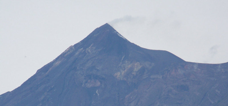
The main reason was twofold: (a) Pacaya is the shortest hike (the road gets closer to the top than any other) and (b) Pacaya is still oozing lava so it's more than just pretty scenery when you get to the top.
So, when we got to Antigua, and every tour company (there are 3 or 4 on nearly every street it seems) was hawking 'Pacaya Volcano Hikes', we signed up immediately. The price for a guided hike seems to run between $5 to $35 US per person. We chose a $8pp hike. The $5 version was a school bus sized bus where the $8 version was a mini-bus. The $35 hike was mainly for custom groups and an English-speaking guide. Our $8 hike was a good choice. We had a small group, a good van driver, and a very good guide, though neither guide nor driver spoke much English. Unfortunately we don't know exactly what tour company it was. It was booked through the Yellow House hotel (right next to Posada Don Quixote on the north side of town).
The mini-van picked us up at our hotel at 6am. The normal tours went at 6am or 2pm. We'd been advised to take the morning tour because the afternoon tour in the rainy season is subject to sometimes violent thunderstorms. We were in such a hurry to make use of our short time in Antigua that we neglected to check the weather forecast when we booked the trip. When we walked out the door of the hotel, we could see signs of rain and there was a pretty heavy fog. "It will burn off." we said optimistically.
Pacaya is actually closer to Guat City. You can't see Pacaya from Antigua because it's behind another mountain. But as the crow flies, it is not that far... maybe 20 miles. However, the winding roads and traffic turned the 20 mile drive into an hour and a half.
When we finally got up the mountain, we were dropped at a little store where the road ended, so we could go to the bathroom, and buy snacks and coffee. Also, this was where we met the guide and where the small boys of the town sold hiking sticks. Dorothy and I bought one for 5Q each (about 75 center), and blessed our good judgement the whole trip. There were a couple of guys with horses standing around too, offering to take anyone up on the horse. (we never asked them the price, I was determined to make it on my own 2 feet...)
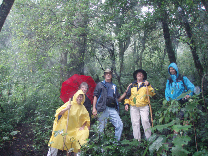 We finally started up the mountain about 10 am. Our group included about 10 people and a guide. It was a mixed group... some college kids and a few of us retirees. The guide had a hard time keeping the group together because a few of the kids kept going ahead and a few of us wanted a more leisurely pace. The guide's job was to get us up and down safely in a limited time, so he was hustling us along, as well as yelling at the young guys to quit going too far ahead. Left, the slower folks.
The trail was not bad at first...it had been terraced a little and there was at least one rest stop with a hut, a 'you are here' sign, and an overlook.
 One or two of the horse guys followed us out of the village. Every time one of us looked tired (almost all the time) the boy would say "Taxi?"
We soon left the nice trail and started up what can only be termed a goat track. This was where Ron decided that it would be very risky for him to take his knees up the mountain. He's had several knee surgeries and felt it would be stupid to blow out a knee while he's on a boat in Guatemala. And he wouldn't consider getting up on a horse. So he went back to the village to wait for us.
Weatherwise, the trip up wasn't too bad. It wasn't raining (yet), just misting a little. But physically it was pretty grueling for us yachties. We all vowed to make time to get out walking when we got back to the boats. It was mostly scrambling up a dirt path at at 30-45 degree incline. (Think about a fast walk up a set of stairs for an hour).
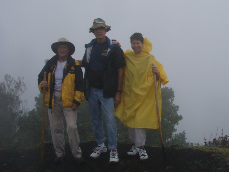
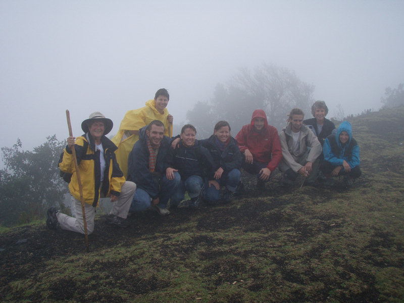 When we got to the top it was pretty neat. We had been all hot and sweaty and shedding clothes, but the wind was blowing here, so we started putting our jackets back on. Though it was misty and cloudy we could see some of the valley below. We took a bunch of group shots, rested a little, and I thought that we'd probably be heading back down from there. But after a short rest, we headed further and started going down again at a fairly steep incline (but not back down the trail we came).
As we were going down, I says to myself "Self, I hope we don't have to walk back up this path." (We did)
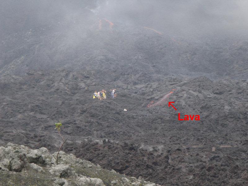 Down a bit and around a corner, and there was the lava field (an expanse of grey rock). We were actually in the crater of the volcano! Cool! We could see some people through the mist across the lava field and then, "OH!, look, there's lava over there!" So we followed the guide, scrambling across the hardened lava. The guide told us (in Spanish) that it had been flowing where we walked in the last 7 months.
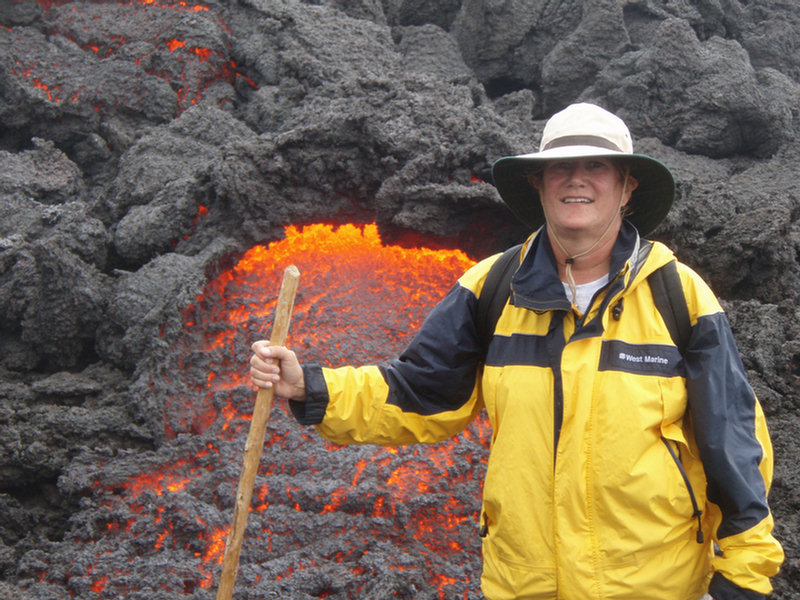 We ended up walking right up to the slowly flowing lava. The guides carried walkie talkies and seemed to have been scouting where the lava was oozing today. You could actualy see it flowing, but it was oozing, not rolling along. I was taking too many pictures to notice, but Dorothy said it had flowed forward about a foot during the half hour we were there. Our guide had a bag of marshmellows and a stick and roasted them over the lava. The hardened rock we were standing on was still warm and steaming from the heat of the volcano. I'm sure it was somewhat dangerous being out there, but the only reports I'd heard about tourist deaths were due to lightning strikes and falling off a cliff, and not due to lava flow.
While we were up in the crater, it started raining in earnest. It was still windy and pretty cold, but there was heat coming from the lava. My camera steamed up on the INSIDE, and eventually quit working. Fortunately the camera Dave had was the waterproof one that "the girls" gave me, and it was fine. (Dorothy's camera had gone back down with Ron).
After 15 minutes of playing around near the lava, the guide rounded us up and marched us back up the side of the crater (argh!) and back down the mountain the way we had come. Only this time, it rained all the way down.
Going down wasn't as physically exerting as going up, but it's really hard on the knees, and on some leg muscles that apparently rarely get used on a boat. And the dirt track had turned really muddy. Our guide was great, stopping to help us over the really gooey spots. Until one... when
the group was too strung out and us slower folks were lagging behind (Dorothy and I because we were tired, Dave because he was trying to keep his white sneakers clean).
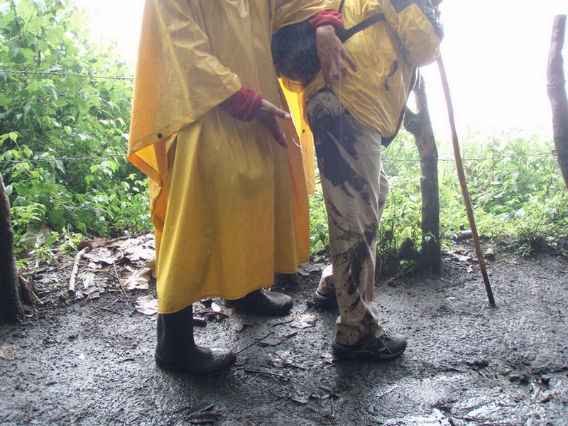 Bottom line, on one muddy incline I grabbed a tree branch to help me down, it broke, and I slipped on my backside, covering my pants with mud. Everyone thought it was pretty amusing, especially Jose the guide, who frankly laughed his ass off when we saw me. I didn't mind. I was only worried that the van driver wouldn't let me back inside his nice van!
We did finally make it to the bottom. I was standing in the downspout trying to rinse the mud off, when some nice Guatemalan lady showed me to a sink behind the store where I could rinse off. With Dave's help I was able to get enough off to get into the van without covering everything with mud.
We made it back into Antigua by about 1:30. It took us several days for our legs to recover from the hike. It wasn't until 3 days later when we did the hot tub at Casa Del Mundo that my legs finally felt better.
 We all joked about the plans to do several more volcanos on this trip... but no one seriously considered doing another one.
See all our Pacaya Hike pics here: Picaya Volcano Hike Album
Wow --------- toooooooooo cool - Sherry were you doing a lava flow walk in that one picture??? Awesome pix and quite an adventure - I am so jealous !!!!
ReplyDeleteBillC
Still stuck at the dock,
s/vGeodesic2
Nice mud there! Looks like you all had fun, in spite of the drizzle, etc. ;-) Deb
ReplyDelete