AIS stands for Automatic Identification System.
It is a relatively new thing on big ships, where a little black box transmits ship information on a VHF frequency. The information includes the following:
- Ship Name and Radio Callsign and MMSI
- Current Location
- Ship Type (Cargo, etc)
- Ship Dimension info (L,W,D,Dr)
- Current Speed and Direction
- Destination
- Status (anchored, underway)
This gets broadcast every few minutes and anyone with a receiver and a little software can pick it up and plot the other ships that are near you. It is mandatory for ships over a given size, and will eventually mandatory for most ships. It is currently not required (and maybe not desired) for yachts. A full-function unit costs a lot of money (over $1000). But you can buy a receiver only for a couple of hundred dollars.
We bought ours from Smart Radio when we were back in the States in June. Dave just now got it hooked up and working last night.
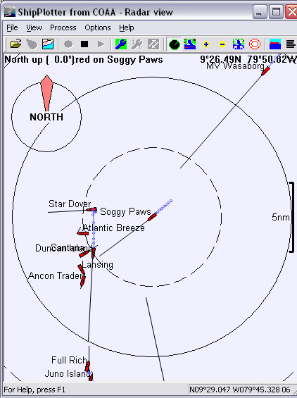
I had fun today playing with the programs that receive the data and plot on a chart or on a 'radar display' (see pic above). I've been playing with Ship Plotter (trialware) and Sea Clear (free).
It is a fantastic tool... significantly better than Radar for seeing other ships while at sea. With our mast-top VHF antenna, we can even 'see' ships on the other side of the Panama Canal, abourt 40 miles away (over land!).
I'll do a full detailed report in our Electronics section on the website soon.
No comments:
Post a Comment