Some details about our anchorages and two night stay in Cayos del Este Sudeste.
This island group, located about 15 miles ESE of San Andreas, belongs to Colombia. It has a barrier reef, 3 islands, and a sandbar with a statue on it. The barrier reef runs for about 5 miles north-south along the eastern side. Though mostly awash, the reef has several wide gaps in it that do not break.
The permanently inhabited island is Cayo Bolivar. There is a small Colombian Navy detachment there, and a light structure that sticks up high over the trees (makes it easy to identify). Nearby to the west is a clearly visible large sandbar with a white statue on it. The light was working, but on a slow blink (15 second interval according to the chart).
The other two islands are located where Cayo del Este is on the chart. They are close together with a cut between, may have originally been one island. These two islands seem to have fishermen coming and going in lanchas, and probably a fish camp there. Though remote, they are close enough to San Andreas that they may also be visited by tourist boats or weekenders.
The water here was very clear (visibility approaching 100') everywhere we went. The chart (M26081S3 - Cayos Del Este Sudeste) seems fairly accurate in features and depths, except displaced about 200 yards to the NW. Our track through a pass in the reef showed up on the chart as 200 yds SE of the pass.
We rounded the NW end of the island about 4pm at waypoint SENW and proceeded south on visual behind the reef, in the deeper water between the reef and the scattered heads to the west. The water was clear, and even at that late hour, it was pretty easy navigating around the reef areas. We looked for a good anchorage in the the extensive sand near the NE corner, but the sand was either 5 feet deep or 35 feet deep, so we kept working our way south.
There was another sailboat anchored west of Cayo Bolivar, so we decided to go down there and check it out. As we got closer to Bolivar, we got a VHF call 'Yate yate, Bolivar'. We eventually figured out they were calling US, and it was the Colombian Navy on the island. The caller spoke only Spanish and wanted to know the name of the boat, our nationality, the Zarpe number, where we were from, how many people on board, and how long we planned to stay. We were not required to physically go to the island. We told them we were going to try finding a 'mas tranquilo' anchorage to the east, and they said 'OK'.
We could see that the sailboat anchored there (a Dutch vessel named s/v Garimar) was rolling a little, so we decided to try to work up closer to the reef and behind Cayo Este.
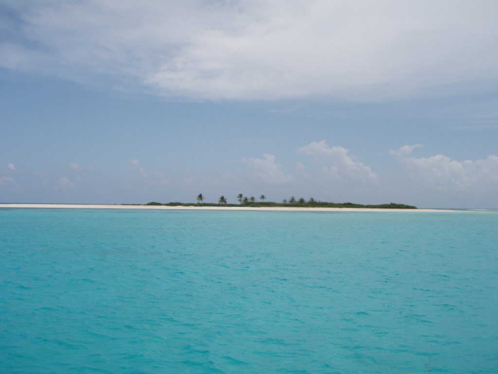
We eventually worked our way up into about 8 feet of deep sand behind Cayo Este, with a minimum depth of about 6-7 feet getting in. See way points SE11-SE13 below, and the anchorage at SEESTE. This is definitely a 'requires good light' entry, and we did have to weave around a few coral heads. This was a relatively calm anchorage in ENE 10-15. However, it would be EXPOSED in SE winds, as the reef to the SE was pretty broken in that area. The water here was crystal clear, and the sandy bottom flat for several hundred yards in all directions. The two cute little cays ahead and off the port beam had sandy beaches and palm trees. Unfortunately, we had the dink on deck, and needed to get going, so we didn't explore the islands. There was no coral within swimming distance from the boat so we didn't snorkel either.
The next morning, we moved to an anchorage to do some snorkeling and allow an easy departure in the wee hours of the morning. We went out from our first anchorage a different way than we came in. This route was deeper than coming in the previous day, and would be a better approach to SEESTE than the first one. See waypoints SE13-SE17 below. We passed a nice anchorage in 9-10 feet sand on the way out, more protected than where we ended up. See SE15Anch.
When we reached deep water, we looped back to the east and anchored between a reef area to the north and east and a grassy area to the south in 15 feet of nice deep sand. This would be a good daytime anchorage for snorkeling, with several nice reef areas nearby and a few conch in the grassy area. It would also be a possible night approach anchorage, or early morning departure anchorage. But it was pretty rolly, with swell from the south wrapping around the south end of the barrier reef, even in light ENE wind. See SE18 and SE18Anch. It might be possible to get away from some of the roll by moving several hundred yards further east in this same anchorage.
Waypoints NOTE: GOOD LIGHT REQUIRED!!!
SENW 12 27.750 N 81 29.713 W Approach waypoint in 50', from the north
SE11 12 24.221 N 81 28.638 W 1st wpt to Cayo Este Anchorage
SE12 12 24.377 N 81 28.131 W 2nd wpt to Cayo Este (skinny water, heads, between 11 & 12)
SE14 12 24.049 N 81 27.786 W 3rd wpt to Cayo Este Anchorage
SE13 12 24.038 N 81 27.561 W 4th wpt to Cayo Este Anchorage
SEESTE 12 23.971 N 81 27.386 W Anchorage at Cayo Este
Note: An easier entry to SEESTE is below
Navigate around Cayo Bolivar to the west and start WSW of SE17
SE17 12 23.727 N 81 28.197 W 1st waypoint in 35 feet, approach from WSW
SE16 12 23.794 N 81 28.136 W 2nd waypoint in 20 feet
Between 16 & 17, coral heads, but none shallower than about 15 feet
SE15 12 23.945 N 81 27.942 W 3rd waypoint
SE15Anch 12 23.945 N 81 27.942 W Nice sandy anchorage in 10 feet
Can also proceed from SE15 to 14 & 13 to SEESTE, carry 7' in.
Easy in/out Anchorage (rolly)
SE18 12 23.679 N 81 28.023 W 1st waypoint in 35 feet
SE18Anch 12 23.713 N 81 27.938 W Anchorage (don't drift left of course in
You might do better anchoring behind Cayo Bolivar
for an easy in/out anchorage.
No comments:
Post a Comment