We got checked in through Customs by the friendliest US Customs agent I've EVER EVER encountered, this morning. And made it to the mall (and Walmart, Office Max) by 10am. Didn't buy much, but sure enjoyed sight-seeing.
-----
At 10/2/2010 1:08 AM (utc) our position was 19°39.49'N 154°54.70'W
Showing posts with label Pacific Passages. Show all posts
Showing posts with label Pacific Passages. Show all posts
Sunday, October 3, 2010
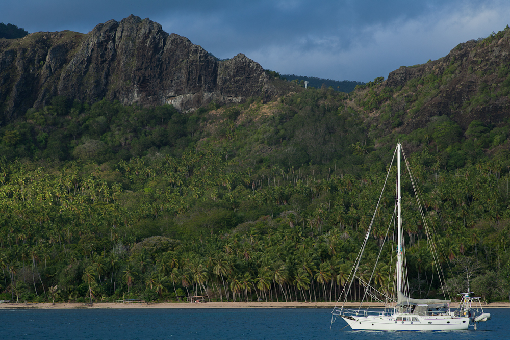
Safe and Sound in Hilo
We dropped anchor and pulled Med-moor style into the sea wall in Radio Bay. It wasn't what I expected. Instead of dancing girls in hula skirts, we got a container terminal. But the price is right, and there's a free bus route to the mall from the front gate of the terminal.
Saturday, October 2, 2010
Land Ho!
We sighted the Big Island of Hawaii at about 7am, and have been motorsailing toward the port of Hilo, on the NE coast. We expect to be anchored in Radio Bay before (JUST before) sunset.
-----
At 10/2/2010 12:52 AM (utc) our position was 19°38.38'N 154°53.33'W
-----
At 10/2/2010 12:52 AM (utc) our position was 19°38.38'N 154°53.33'W
Friday, October 1, 2010
Enroute to Hawaii - Final Day
Only 75 miles to go!!
The wind got really light about 6am yesterday--just as had been forecast for nearly a week. I'm not familiar enough with the North Pacific weather patterns to know exactly what caused this big 'hole' in the tradewinds, but it's here. I do know there's an early cold front stalled out just above Hawaii. In a few days it will be back to 15-20 knots where we are, but right now it's like a lake.
So we reluctantly started our engine and started motoring in. We have now been motorsailing for almost 24 hours, at moderate RPM. Other than the sound of the engine, it waw a pleasant day... very sunny skies and smooth seas. We have a big long slow swell that means the surfers are going to be happy this weekend, and as we go over each one, it feels like Soggy Paws is having to climb a hill.
We put the fishing lines out yesterday morning after breakfast, and 10 minute later got a hit. It was about a 5' Marlin. He was pulling the line out like crazy--Dave thought he'd lose it all before he got him stopped. So we were a little relieved that he got off. We saw him jump a couple of times, but he cut the line and was gone. Dave re-rigged the lines but we have yet to get another strike.
Of the other two boats we've been traveling with, Apple, the Jeanneau 44, arrived in Hilo yesterday sometime. Infini is about 160 miles behind us, and as of yesterday afternoon, was still trying to sail, and making about 3 knots. Infini has a leaky injection pump and wants to minimize use of their engine.
We could have sailed a few hours more, but Dave got severe 'horse headed for the barn' syndrome, and just wanted to get in. He got it in his head that we're going to watch the Gators beat Alabama on Saturday, and that was that.
Fortunately, we have made very good time since cranking up Mr. Perkins. Motoring at moderate RPM, with the sails still up, we've been able to average about 6.3 knots. Our ETA is now Friday afternoon about 5pm local time.
We understand the Agriculture people confiscate any fresh produce you have left, so we've been having a bonanza--trying to eat everything up. As we ate down our fridge, we discovered a few bags of tomatoes and green peppers that we didn't know were there, and we still have lots of onions, potatoes, cabbage, and carrots. We tossed the last of the bananas a few days ago, and ate our last Pamplemousse (French Polynesian grapefruit) yesterday. We have one apple left.
So we will anchor up in Radio Bay around sunset. Radio Bay is in the Hilo harbor, at the NE tip of "the Big Island" of Hawaii. We'll have a good dinner, get a full night's sleep, and check in with Customs tomorrow morning. Then we understand there's a bar nearby with good fast wifi, and hopefully a TV or two with college football on.
-----
At 10/1/2010 2:22 PM (utc) our position was 18°59.84'N 154°07.14'W
Sunrise at Sea
I am a morning person, and I've always loved to go for an early morning walk on the beach and watch the sunrise.
For most of the last year, we've had a watch system of 3 hours on and 3 hours off, and the way it worked out best gave Dave the sunrise. But we've been fiddling with our watch system over the last couple of passages, and this time, I get the sunrise. I'd almost forgotten why I love that dawn watch so much. I love watching the light slowly creep into the sky. Starting about an hour before sunrise, there is a barely perceptible easing of the darkness in the East. Then gradually, the light gets brighter, and most days, I am rewarded with some beautiful colors just before the sun pops up over the horizon.
Today is another gorgeous morning. We are STILL sailing, though the wind is down to about 8 knots. I can't believe this fat tub (don't let Dave hear me say that), can still be moving along at 5 knots in only 8 knots of wind. But we have managed to keep eeking out 5 miles every hour through the night.
The forecast is for the wind to continue dropping. We have done so well over the last 36 hours that Dave has gotten it in his head that we can make Radio Bay (the anchorage in Hilo) by Friday night. We will likely get in after dark, and will soon have to crank up Mr. Perkins. But we're both so looking forward to a good night's sleep.
The approach and entry into the Hilo harbor area, and Radio Bay, is well charted and well bouyed with lighted bouys. So we will likely go in anyway, even if we arrive after dark.
209 Miles to anchor down in Radio Bay!!
-----
At 9/30/2010 4:13 PM (utc) our position was 17°18.24'N 152°33.90'W
Wednesday, September 29, 2010
North Pacific Shipping Routes
Boy, we saw more ships at sea today than we've seen in the previous 6 months! (3) Must be getting close to civilization. The last ship that passed us, near sunset, passed within about 300 yards. That's really close.
We saw him on AIS about 13 miles away, he was coming up behind us and slightly to starboard, on a converging course. The AIS indicated he was bound for Taiwan, probably from the Panama Canal, and we could see that he was tracking right along 15 N latitude, going straight west.
For the longest time the AIS was saying that the CPA (closest point of approach) would be .25 miles. So we finally called him on the VHF and told him where we were in relation to him. After a bit of conversation, he finally said he saw us on his radar (about 6.5 miles away).
We could see on the AIS information that he had changed course a tiny bit to starboard after we talked to him, to pass in front of us. But visually, he was still coming right at us, and the CPA kept showing that he would come very close (.015 NM). I was pretty nervous, but Dave said "He sees us and he won't run us down". When he finally drew abreast of us, he sounded his big air horn, and we could see someone out on the bridge deck waving at us. I got a great picture of them crossing in front of us.
Another ship we saw today was bound for Valparaiso, Chile. This is the second ship we've seen coming down that same course line from Hawaii toward South America. He didn't answer our hail on VHF, but we were well away from him. Dave says he was probably carrying pineapple from Hawaii to South America. If you draw a route in Maxsea (our charting program), from Hawaii to Valpariaso, the Great Circle route goes right past where we were.
We have had another 24 hours of nice sailing, and we anticipate tomorrow to be nice as well--though the wind is forecast to start slacking off.
394 miles to Hilo, we expect to be in on Saturday morning.
-----
At 9/29/2010 5:35 AM (utc) our position was 15°07.59'N 150°09.64'W
Enroute to Hawaii - Day 13
We had a quiet night, the night before last, and a good sail yesterday. But as predicted, the winds are starting to relax.
We got down to about 4 knots of boat speed in the middle of the night last night, with the sails slapping, and finally relented and turned on the engine. 4 knots would be do-able if it weren't for the fairly large swell that rolls us around.
We motorsailed for a few hours, charging batteries and running the refridge.
Fortunately, the wind has come back to 12-13 knots this morning, and we are under sail again.
We called the Hilo Harbormaster on the Iridium phone yesterday, to ask a bunch of questions about arriving on a Saturday. He seems like a nice guy. Usually we would be trying NOT to clear in on Saturday (just sit on the boat and wait til Monday), to avoid overtime fees. But Dave has got it in his mind that he wants to watch some football games on Saturday afternoon.
We are still trying to get ahold of the Hilo Customs office--they were not answering their phone yesterday. The Harbormaster said there were 2 cruise ships in Hilo, that's probably why.
The forecast is for the winds to stay in the sailable range today, though getting progressively lighter, and start dropping off to 'too light to sail' tomorrow. We are hoping to sail as long as possible. It looks like we may have to motor the last 36-48 hours (or sit and roll and slap for 2 days til the wind comes back).
We are 465 miles from Hilo, and should be able to easily make port by Saturday morning.
-----
At 9/28/2010 4:59 PM (utc) our position was 14°30.99'N 149°04.29'W
Monday, September 27, 2010
Enroute to Hawaii - Day 11
<yawn> Another long day on the high seas.
We had a very quiet night last night--the wind was light and we ghosted along, averaging only 4 knots. But we were able to keep sailing in mostly the right direction. I had to talk Dave out of turning on the engine several times, but fortunately every time the wind dropped off to the 'too light to sail comfortably' range, it would pick back up just enough to convince Dave to keep sailing.
For a few hours this morning we had some really nice wind--close to 15 knots, but it soon eased off again to the 10 kt range. We still were able to average 5 knots for most of the day. Our noon-to-noon mileage was 121 miles--the lowest so far this trip.
But it was a nice sunny day, and really a beautiful sail. However, we've been at sea for 11 days, and we are ready to "get there".
All 4 boats we've been tracking on this trip are now out of the ITCZ, and though we all suffered through about 36-48 hours of drizzle and shifty winds, no one clocked over about 22 knots, and no one saw any lightning. Pretty different than we expected. Hope we get as lucky on our return trip in April next year.
We have seen only 2 ships so far in 1300 miles of sailing. One was a freighter who crossed our in the middle of the ITCZ. It was enroute from Los Angeles to New Zealand. We 'saw' him on the AIS and the radar, and talked to him on the radio, but never actually saw him--even though he passed within 2 miles of us. The constant drizzle obscured him completely. Usually a freighter of that size is lit up like a Christmas tree, and you can see them 10 miles away. Another ship just passed us a couple of miles away. Again, we saw him first on the AIS, then went out and looked for him.
For the non-boaters, AIS stands for Automated Identification System. It is a new gadget that big ships are required to have that broadcasts a digital signal over the VHF radio (receivable about 25 miles away), with the ship info, location, speed, and direction. We have a receiver aboard that receives that signal, and plots it on our computerized charting system. It's pretty cool. Way better than radar. The ship's info includes the name of the ship, what kind it is (freighter, tanker, etc), how big it is, and its destination. I think we'll be upgrading our AIS receiver to a transmitter when we get to Hawaii. That way THEY can see US too.
658 Miles--about 5 more days--to Hilo, Hawaii.
-----
At 9/27/2010 7:14 AM (utc) our position was 12°41.29'N 146°17.14'W
Sunday, September 26, 2010
Welcome to the NE Trades
We are happy to report that we are finally clear of the ITCZ. We ended up turning on the engine last night about midnight, after I spent a frustrating 4 hours trying to keep us going in the squally conditions and shifty wind and really confused seas. When Dave took over, he said "That's it, I'm turning on the engine.". It was a good decision--the GRIB files showed stuff brewing up in the ITCZ and we just wanted to get clear.
By 6am this morning, we were at 10-10N, with some sunshine and fluffy white clouds, instead of the low gray clouds we'd had for the past 2 days. The wind filled in nicely from the NE, and we turned off the engine, rolled out the genoa, and have been sailing all day.
We had a fabulous sunset this evening--complete with a green flash, and then some great after-effects with the clouds. And we were visited by porpoises today as well.
Unfortunately, the normally-strong tradewinds are forecast to get lighter and lighter, and then totally die in a couple of days. I'm not exactly sure what's causing it, but it looks like we'll have to motor in to Hilo the last 48 hours. I keep hoping the GRIB files will change, but so far that has been steadily predicted for the last few days.
778 Miles to Hilo. ETA probably sometime Saturday, Oct 2.
We understand the Florida Gators beat Kentucky today. Go Gators! We'll be rooting for them to knock off #1 Alabama next weekend--maye we'll get in soon enough to even watch the game on TV!
-----
At 9/26/2010 6:05 AM (utc) our position was 11°11.94'N 144°47.72'W
Saturday, September 25, 2010
It Was A Dark and Stormy Night
Picture Snoopy sitting on his dog house with his typewriter...
Yes, we have a dark and stormy night. We have been making our way NW through the worst of the ITCZ today. We motored all night in light winds and rain. In the morning, there was enough wind to turn the engine off and put the sails out. But we've had squally weather and shifty winds all day. We've made about 10 sail changes today--genoa in and out, staysail in and out, pole up and down twice. The wind has gone from SW to NE--and all points in between, and between 0 and 20 knots. So far, nothing even approaching a Florida thunderstorm--no lightning and no wind over about 20 knots.
We celebrated passing 9°N at 4pm today with another black squall line ahead of us. And 3 hrs later, we are still in the rain, and hard on the wind with the wind out of the NE.
Well, maybe 10°N will bring us clear weather and steady winds--hopefully dawn will bring us 10°N and sunshine.
We are now well past the halfway point. Only 924 miles to go (about 7-8 days of this).
-----
At 9/25/2010 5:33 AM (utc) our position was 09°17.78'N 143°18.55'W
Friday, September 24, 2010
Greetings from the ITCZ!
We sailed all night last night and most of the day today, wing on wing. It's a nice rig--genoa poled out to windward, main vanged to leeward, and the staysail sheeted on the centerline. Very stable and pretty fast even in light air. We can tolerate course variations of up to 60 degrees (briefly), so the autopilot can handle the steering.
If we get a squall, we roll the genoa up and leave the pole set.
About 3pm, the wind came up and seemed to be shifting SW (as forecast). This was good, so we dropped the pole and gybed the genoa, expecting to have a nice broad reach up our course line. However, an hour later, we were in rain, and the wind went back SE, and then very light. So we reluctantly started the engine. We are now motorsailing with main and staysail sheeted tight to stop the roll. Even though there is only about 5 knots of wind, the seas are still big enough to be uncomfortable.
We had a nice civilized dinner tonight, with the table up and everything. Lamb chops, fresh mashed potatoes, and cucumber salad. Crew morale is good. We are looking forward to getting through the ITCZ within 48 hours. We are holding our breath that nothing major will spin up near us while we're crossing through.
Geek alert: With the Iridium phone hooked up to Sailmail, I can download a very small IR satellite picture from NOAA Honolulu's website. It has all the active storm cells along the ITCZ highlighted. I then pulled it into Sea Clear (a shareware charting program that lets you create your own charts), added some reference points, and voila, I can see our boat moving across the satellite picture. Pretty cool, and really helps in trying to pick our way through the hot spots in the ITCZ.
Only 1044 nautical miles to go to Hilo. We are about halfway. ETA probably sometime Saturday, Oct 2.
-----
At 9/24/2010 5:30 AM (utc) our position was 07°12.20'N 142°38.98'W
Thursday, September 23, 2010
Beam Me Up, Scotty!
Enroute from Marquesas to Hawaii, Day 7.
We are not quite halfway to Hawaii. The fun sailing is over and now what's left is over 1,000 miles in light and variable winds, interspersed with scattered squalls, and a few low pressure areas. Even the tradewinds that should normally give us a booming sail on the last leg to Hawaii, seem to be shutting down. At least that's the current long range forecast.
So we're at the inevitable 'beam me up' phase of the trip, where we are tired of all the 'fun', and just want to get it over with. Unfortunately, the warp drive is down and so we're just going to have to continue sailing slowly along at 5 knots.
Today's big THANK YOU goes to our friends: Winnie, Jim Yates and Barbara Emmons of s/v Carisma, and John and Linda on Nakia. Thanks for all the help and info you have sent our way!!
-----
At 9/23/2010 5:32 AM (utc) our position was 05°05.22'N 141°56.26'W
Tuesday, September 21, 2010
Back in the Northern Hemisphere
We crossed the Equator at about 11am today. It's nice to be back where the High Pressure areas rotate clockwise, and the cold weather comes from the North, like we are used to. I can stop looking at weather maps standing on my head.
We are still sailing almost due north--heading for a waypoint somewhere near 10N 142W, where we'll 'fall off' (change course) for Hawaii.
About 1,380 miles to go to Hilo, on the Big Island of Hawaii.
-----
At 9/21/2010 5:53 AM (utc) our position was 00°48.28'N 141°38.61'W
Monday, September 20, 2010
Enroute to Hawaii - Day 4
I hate to sound redundant, but we're still having a fantastic sail. 1,496 miles to go, as the seagull flies. All systems aboard are working well, and the crew are doing great. Nice meal of pork chops, baked potatoes and green beans for dinner tonight.
Dave's cousin Bryan reports that the Gators whupped the Tennessee Vols yesterday... sorry, Sally. Go Gators!!
-----
At 9/20/2010 6:26 AM (utc) our position was 01°22.76'S 141°33.68'W
p.s. PLEASE, if you want to respond to our emails (and we always look forward to hearing from you), do NOT send our original message back to us along with your message--we receive this email via HF radio, and every extra byte counts. Attachments and pics get automatically stripped from incoming emails, so pls send those to our svsoggypaws email address instead.
Sunday, September 19, 2010
Enroute to Hawaii - Day 3
Wow, what FANTASTIC sailing. We made 150 nautical miles in our first 24 hours--that's the best 24 hour run we've ever had.
Now the winds have moderated some, but it's still really nice sailing weather--10-14 knots on the beam, with moderate seas, and sunny skies. The moon is nearly full at night, so we've got nice shiny nights, too.
So far, the forecast for our passage through the Inter Tropical Convergence Zone (ITCZ) (still 5 or 6 days ahead) looks like it is going to be pretty easy. We are prepared for a day or two of motoring to get through it, but not anticipating any nasty weather.
"Only" 1,660 miles (as the seagull flies) to Hilo... Current ETA probably 2nd or 3rd of October.
Of course, the troubles from home even follow us out into the middle of the Pacific Ocean. I got an email from Capital One about a suspected fraudulent charge on our credit card. It was only $12, but after 3 satellite phone calls (one to my daughter to make sure she hadn't done anything unusual), they refused the charge and canceled the card. But now I'm left wondering what 'automatic' payments I have on that card that might bounce in the next 2 weeks. (Since we had to cancel some cards and re-arrange finances after our 'swim' in Easter Island, I've lost track of what thing is on what card).
And my daughter moves out of our condo in Satellite Beach in 2 weeks, for a new job with GE in Cincinnati, and we still don't have a renter lined up for the house. Sigh. But we just might get to stay in our own home when we go home in November!!
We are in radio contact twice a day with the other 2 boats out here... Infini is 50 miles east of us and Apple is about 35 miles north of us. Both too far away for VHF, so we have an SSB schedule. And we are still able to check in every morning on the French Polynesia Breakfast Net (1730z 8164 USB), which our friend John on Nakia is now running single-handed, since we have left French Poly. We are also doing an evening check-in on the Pacific Seafarer's Ham net (0300z 14300 USB).
In between all these things, we're reading, sleeping, eating, and trying to keep "Henry", our steering vane, on track. This is the first passage that we've actually used Henry for any period of time. Using the windvane saves energy (about 30ah per day), but the sails have to be "balanced" for it to work properly. It's a real learning experience, but I think we've finally figured out how to balance Soggy Paws--at least in these winds.
No fish so far, but the fishing line has only been out for about 4 hours. We don't put the fishing line out unless the seas are really low and/or we'll be in port soon (We don't want Dave cleaning a fish on the back deck in boisterous conditions).
-----
At 9/18/2010 7:16 PM (utc) our position was 04°45.20'S 141°30.63'W
----------
radio email processed by SailMail
for information see: http://www.sailmail.com
Friday, September 17, 2010
On Our Way to Hawaii
Well, we finally made it out of Anaho Bay at noon today. The winds eased off overnight last night to a nice 15 knots, and the skies cleared by mid morning. We got our final preps done--dinghy loaded, sail covers off, engine checks done, computers and GPS's programmed, living spaces stowed, etc. The anchor came up without any problems right at noon.
Since then, we have been having a great sail--15 knots on the beam--all afternoon. Just like when we used to go sailing for fun!! We averaged 7 knots for 3 hours!!. Now the moon is up, and the wind has eased to a nice 12 kts. We're going a little bit slower, but the motion is easier, too. I could do THIS for 2 weeks, easily.
Our friends on s/v Infini left about 2 hours ahead of us, and they are heading for a slightly different waypoint to go through the small islands and seamounts NW of Nuku Hiva, so they are about 10 miles NE of us right now, on a more northerly course. Another boat, Apple, left at the same time we did, and they are about 3-4 miles NW of us. We are all still in VHF contact, but by morning will likely be too far apart for VHF. We have an SSB schedule planned to chat every morning and evening, swap positions, and share weather information
"Only" 1,854 miles to go! At our historical average speed of 135 miles per day, we should be in Hilo Hawaii on Sep 30 or Oct 1. (but don't book your tickets yet!). The big unknown, speed-wise, is the ITCZ (formerly known as "The Doldrums"). This is an area of variable winds and squally weather. Historically boats could take weeks drifting around before they managed to break through an area like this. Fortunately, we have an engine in great shape and aren't afraid to use it. So the minute the wind dies off, we'll crank up Mr. Perkins and motor on through it.
We're not exactly sure what route we'll end up taking. Historically, people have headed north out of the Marquesas and set up to cross the ITCZ at around 140 west longitude, and then fall off for Hawaii. But we've been playing with the routing optimization software in the Maxsea charting program, and are going to follow its advice (until we decide not to). It takes in the GRIB files (weather predictions) and your boat's Polars (a table indicating what speed you can make in various wind conditions) and optimizes your route. Theoretically...
Sometimes Maxsea can come up with some pretty whacky results. But for now, I agree with what the optimization suggests. So we are headed 340 degrees (NNW) til tomorrow morning at least. This is almost directly on the rhumb line (the straight line course to Hawaii).
-----
At 9/17/2010 5:24 AM (utc) our position was 08°04.90'S 140°20.09'W
Preparing for the Sail to Hawaii
Current Location: Anaho Bay, Nuku Hiva, Marquesas, French Polynesia 08°49.35'S / 140°03.89'W

Beautiful Anaho Bay
Our main focus while here in Anaho Bay has been getting ready for the two-week, 2100-mile sail to Hawaii. In between hikes and snorkeling expeditions, both us and our friends on Infini have been working on boat maintenance issues--bottom scrubbing, rigging checks, leak fixing, etc etc.
I have also pre-cooked about a week's worth of meals, so all I'll have to do is pull something out of the freezer and heat it up.
Plus I've spent a lot of time over the last month collecting weather information about the trip. Mainly just watching weather patterns so we know what to expect. It should be a pretty decent trip. We are starting on a good weather window--wind today should be just aft of the beam at 15 knots. We'll sail N-NNW for the first week or so, until we get across the ITCZ (motoring if the wind gets too light), and then fall off in the northeast trades for our destination of Hilo Hawaii.
Though Sailmail gives us great access to many bits of weather information, we have enlisted our friend Winnie, a professional meteorologist based in Florida, to keep an eye on the 'big picture' for us. We are also getting advice from a Danish guy named Karsten who has been doing Pacific weather for cruisers out of Panama for awhile.
We will be in company with 2 other boats--Infini and another boat here headed for Hawaii called Apple. Apple is a Jeanneau 44, and is likely to go faster than us--though he swears he'll try to slow down and stick with us.
We expect to make landfall in Hilo, Hawaii sometime the first week in October. The direct-line course from here is about 2100 miles, but because of the way the winds go between here and there, we may dog-leg east a little bit from a direct course.
In the last couple of months, we have finally gotten around to doing some of the less important tasks on our list--things like hooking our GPS to our EPIRB, so our emergency beacon will broadcast an accurate position if we sink. Though somewhat important, it never made it high enough on the list before our long trip to Easter Island. So we are more prepared for this trip than we ever have been. And the crew is ready...with over 6,000 miles under our belt already this year, we feel pretty seasoned!!
We plan to do a blog post and update our position at least daily. The easiest and quickest way to see where we currently are is via the Findu link:
http://www.findu.com/cgi-bin/find.cgi?call=KN4TH
But there are several other ways--check our Positions page on the website: svsoggypaws.com/positions.htm
Wednesday, August 11, 2010
Anchored at Fatu Hiva
Current Location: Hana Vave (Bay of Virgins), Fatu Hiva, Marquesas, French Polynesia 10°27.90'S 138°40.06'W
After a long day of bashing to windward in 20-25 knot winds, we arrived at our destination yesterday about 3pm. What a relief it was to get into the wind shadow of this big high island. We sighted land at about 35 miles out--at about 9:30 in the morning, but it took us nearly all day to finally reach sheltered waters. We motored slowly along the coast, sightseeing--about 100 yards offshore, but still in 250' water.
This bay is beautiful. Like the rest of the Marquesas, it is volcanic, and rises steeply out of the water. The early sailors named this the Bay of Penises, because of the large rock spires that punctuate the sky. The priests who came later, add an 'i' to the 'Verges', to make it Vierges, which means 'virgins'. So officially, this is known as the Bay of Virgins. The Marquesan name is Hana Vave (or Hanavave).
We are hoping for rain, but so far only a sprinkle. We are really salt-encrusted. Dave washed the cockpit down yesterday after we arrived. Though we were well sheltered from getting drenched by big waves behind our cockpit enclosure, we only put up one side, so we get ventilated on the other side. But this makes a vacuum and sucks spray from the lee rail into the cockpit. Thank God for our big watermaker, that gives us enough fresh water to rinse things when we need to. But the rest of the boat will have to wait for a big rain.
There is only one other cruiser here--a small sailboat--a young French family with 2 small children, on a boat called Lares. During "Puddle Jump" season there must have been 20 boats in this anchorage--we are glad we are here now (waving good-bye to the PJ-ers as they hurry west now to Suwarrow, Niue, Tonga, Fiji, and NZ.
There is a small town here--but, sadly, they don't have a bakery here. No fresh baguettes for us today. But the people on Lares gave us a pampelmousse (grapefruit) yesterday when they stopped to chat. They had bags of fruit and veggies in their dinghy, and fresh green bananas hanging in their rigging. They said it was easy to trade for what you need.
We plan to stay here for 2-3 days and then head north for the town of Atuona on Hiva Oa, for some provisions and internet. We hope to hike to the waterfall today.
-----
At 8/10/2010 4:06 PM (utc) our position was 10°27.90'S 138°40.06'W
----------
radio email processed by SailMail
for information see: http://www.sailmail.com
Monday, August 9, 2010
Sailing Like a Scalded Dog
Well, the wind has come up as forecast. And we have managed to claw our way far enough to windward over the last 24 hours, that we can now fall off a little. So we have eased the sheets, and this old girl (not me, the boat!) really likes these conditions. We have a double-reefed main, the staysail, and about 60% of our genoa out, and we're averaging 7 knots, right on course for Fatu Hiva. Woo hoo!

Sailing On A Close Reach

Dave Hangs On (In Our Nice Dry Cockpit)
The wind is supposed to gradually increase through the night up to about 18 knots, but stay south of east. So we hope we'll have a nice sleighride into the Bay of Virgins (Hanavave) in Fatu Hiva, by about 3pm tomorrow.
-----
At 8/9/2010 6:39 AM (utc) our position was 12°04.59'S 139°40.84'W


The wind is supposed to gradually increase through the night up to about 18 knots, but stay south of east. So we hope we'll have a nice sleighride into the Bay of Virgins (Hanavave) in Fatu Hiva, by about 3pm tomorrow.
-----
At 8/9/2010 6:39 AM (utc) our position was 12°04.59'S 139°40.84'W
Sunday, August 8, 2010
Having a Great Sail
We are not quite half way to the Marquesas. Our first day was quite relaxed--the wind was very light, and we opted to motor close in along the coast of the twin atolls of Raroia and it's close neighbor to the north (with no pass), Takume, a total of 25 miles. We faithfully dragged our fishing line the whole way, but no luck.

Leaving the Pass at Raroia

Sailing along Takume
Today we were kind of sweating the wind--it was forecast to pick up a little and go a little south of east--which would make a great sail for us. The swing to the south was delayed by about 8 hours--it wouldn't have been a very pleasant trip if it hadn't switched. But finally about 2pm today, we got about a 30 degree wind switch.
Just at sunset we sailed close past the twin atolls of Tepotu and Napuka. They would be a great stop time-wise, except neither has a pass and there's really no place to anchor. We had one report from an SSCA newsletter of a boat that stopped there--he hand set his anchor on top of the coral, and his stern was in 100' feet. Another boat (Migration) tried to stop there 2 years ago, and couldn't. We could see a few buildings ashore, and a guy out fishing in a plastic kayak. But it was very close to sunset, so we sailed on by.
Now we're sailing along about 6 knots on a close reach, just a little high of our course. The wind is supposed to continue to strengthen, and we want to put a little "easting" "in the bank", just in case.
We got such a slow start that our ETA at the Bay of Virgins in Fatu Hiva is now close to sunset--it'll be a close thing whether we make it in before dark or not. And then there's always the choice of what to do--lay off all night and wait for daylight, or try to go in carefully after dark and get an anchor down and get a good night's sleep.
Let's hope this wind holds!!
-----
At 8/8/2010 7:15 AM (utc) our position was 13°46.93'S 141°09.13'W
Friday, August 6, 2010
We're Outta Here (Tomorrow)
Looks like we finally have a weather window to make our way from Raroia to Fatu Hiva in the Marquesas. Our plan is to leave here late morning tomorrow, and we should arrive in Fatu Hiva (Bay of Virgins) on August 9th. The wind forecast is pretty good... 15-20 knots from E to SE.
We'll be checking in as usual on the Polynesia Breakfast Net in the mornings, and the Pacific Seafarer's Net in the evenings. We will also try to update our position about twice a day. You can track us using one of the links on this page:
http://svsoggypaws.com/positions.htm
-----
At 7/30/2010 6:02 PM (utc) our position was 15°57.35'S 142°18.97'W
----------
radio email processed by SailMail
for information see: http://www.sailmail.com
Subscribe to:
Comments (Atom)