Yesterday afternoon in a particularly "boisterous" patch of weather, my ASUS Eee PC (which was not properly secured) launched itself off the nav station onto the floor, with a few pieces flying. It was not on, thank god. But Dave, who picked up the pieces, was sure it was toast.
The little blinking light that indicates "standby mode" was still blinking, so I was hopeful that it might still be alive. When I first tried to start it up, I got a scary disk error (OH CRAP!). But after re-seating the disk drive in it's socket, it started up. Thank God for small favors!!
I am well prepared for disaster recovery--you absolutely have to be on a boat. Just the salt air will kill a computer in a year or two--one little teeny salt water drip can be fatal--not to mention hauling the computer all over creation in a backpack, and the "at sea" encounters like yesterday.
I keep pretty good back-ups, and I have a spare computer I could migrate to, but the last time I backed up was about a week ago. And who has time to re-create one's life on different computer, no matter how good your back up is??
This little cheapo ($350) computer that I bought in 2009 has been such an incredible buy. I wish I'd bought 2 or 3 of them. We have bought 2 of its successors, also called Eee PC's, but not nearly as well built. I'd like the same case, same keyboard with a faster processor, more memory (mine is limited to 2GB) and a bigger HD... for the same $300 price range. Too bad the company has "upgraded" their PC line.
Showing posts with label Pacific Passages 2014. Show all posts
Showing posts with label Pacific Passages 2014. Show all posts
Monday, August 4, 2014
In the Philippines
We are happy to report that we rounded Cape San Augustine this morning at 0845 and we are officially in Philippine waters.
The marina we are headed for (Holiday Ocean View in Samal, near Davao) is too far away to reach in one day, so we needed to find a stopping place overnight. You don't sail at night in coastal waters in the Philippines--too many FADs, fishermen, nets, etc.
With S-SW winds, none of the anchorages we had marked along the west coast of the SE peninsula in Mindenao were looking very good. We picked out one--at Sigaboy Island--that looked like it might work, but the wind was too far south. The only spot where there were anchoring depths was not behind the island with the south-ish winds we had. And about the time we were looking, the winds had picked up and were howling through the area, with a bit of a venturi effect near the island. So we moved on.
A few miles north, Dave picked out a decent anchorage in a big cove, I think called something like Baksal Cove. We anchored at 06-40.6N / 126-04.9E, in about 25 feet of water, off a fishing village. "Off a fishing village" is an interesting term in the Philippines, as pretty much every bay we went by on our 25 miles up the coast, had a fishing village. Basically a row of shacks along the beach with 20-40 motorized outrigger canoes pulled up on the beach.
The Filipinos are incredible. It's hard to convey their fishing-ness. Several hundred miles off the coast of Mindanao, in very deep water, our friends on Carina passed a "FAD" with a medium-sized (say, 30-40') fishing boat accompanied by a number of outrigger canoes. And we saw them in all shapes and sizes today...anything from a one-man canoe to a giant community-sized fishing or transport vessel. Here they are called "bancas" (bong-kas)...outlandish looking trimaran things with motorized propulsion (pictures to follow).
We are getting up at the crack of dawn tomorrow (even Dave!) to make the last 40 miles to the marina.
-----
At 08/04/2014 12:40 PM (utc) our position was 06°40.60'N 126°04.90'E
http://svsoggypaws.com/currentposition.htm
Sunday, August 3, 2014
Bashing the House to Weather
For you non-sailors, the term "To Weather" means to go into the wind and waves.
Here we are enroute to the Philippines now on Day 4. This is definitely getting old. We have finally reached the "favorable" current (south-bound), which makes it easier to make the heading we need to get around the point. But the southbound current against the northbound wind has made the seas really short and steep. So we are bashing and crashing--big sheets of salt water coming over the bow. My tomato plants are definitely NOT happy. And neither are we.
Fortunately, we made the right decision in motorsailing further south to reach lighter winds. We have better weather here, while two of the purist-sailor boats that left with us were "hove to" this morning in 20-30 knots (temporary squall conditions). While they sneer at our wimpy-ness, we know they are wishing they were where we are.
There is a typhoon that was just forming as we left Palau, and was supposed to track off to the northwest and not be a factor. It has stalled about 600 miles north of us and turned into a "Super Typhoon". This is making what looked like an ideal weather window... 12-15 knots... into a less than ideal window. We've had 15-20 all day and it's clocked a little to be more on our nose, and the forecast is for it to continue like this for at least another day.
But because we've been motorsailing for two days now, we are now less than 24 hours from rounding the point (God willin' and the creek don't rise), and then we'll be in more protected waters and going with the wind and the current--and only 60 miles from our destination. We probably won't make it all the way into the marina tomorrow, but will likely stop somewhere to rest up and make it into the marina on an easy day on Tuesday.
We spotted our first FAD this morning. It was a large day-glo orange cylinder in 6,000 METERS of water (~18,000 feet). We can't imagine them being anchored... they MUST be just launched and floating. But what a hazard to navigation! They are typically made out of steel and are roughly the size of a refrigerator. In calm weather with a good radar, you might be able to pick them up on radar, but not in these seas (and not with our tired old radar mounted on the arch).
We're in no danger, just discomfort. We have 3 other boats out here with us to commiserate with, and a number of boats waiting for us at the marina in Samal with a cold beer. We're just ready for it to be over.
-----
At 08/03/2014 12:24 AM (utc) our position was 06°51.15'N 127°55.53'E
http://svsoggypaws.com/currentposition.htm
Saturday, August 2, 2014
On the Way to Philippines - Day 3
We were having a great sail, but going slowly in the wrong direction, and Dave just wants to "Get 'er done" and get there.
So yesterday afternoon, after a long discussion between Dave (the motorhead) and me (the sailor) we cranked the engine up and started motorsailing directly toward Cabo San Augustine, the SE point of land on Mindenao that we have to round to get up into the Gulf of Davao.
Also, the best wisdom in strong current is to make all speed directly across the current, to get out of it sooner, so that's what we're doing. Our current plan is to keep heading WSW until we strike the favorable southbound current, and then tack over and head south in the favorable current. But the plan changes with every new forecast.
There's another typhoon brewing well to the north of us, and what looked like a nice settled weather window is looking less settled as the typhoon spins us. So Dave's "let's quit playing around out here and get there" is somewhat justified.
Also, we got wind of an anchor-chain re-galvinizing expedition in Davao, our destination. To get in on that, we have to be at the marina by Tuesday evening. If we keep motorsailing we'll just barely make it. (saving lots of money on chain/re-galvanizing but spending about $3/hr on diesel fuel).
One other factor out here I forgot to mention. The Filipino fisherman fish offshore in small boats up to 180 nm from the coast. So once we get that close to shore, we have to keep watch for possibly unlit/unmarked FAD's (fish aggregating devices). They can be anything from a wooden raft to large metal cylinders, and anchored out in deep water. We have waypoints for ones that have been spotted by others, so we know about where they start appearing.
The fishermen are also out fishing at night along the coast in small unlit boats, often with nets. So you can't do coastal passages around here at night--another reason why we decided to stay offshore, rather than head for the coast and then creep along in the protection of the coast.
We're using RTOFS requests from Saildocs to get the current information. Last time I tried it (about 6 years ago), I didn't get anything, but now I do--a 3-day forecast for what they expect the current to do. It is a GRIB file just like the GFS forecast gribs, and can be viewed in OpenCPN or ViewFax.
Anyway, all is well out here, and we're "only" 215 nm from rounding Cabo San Augustine, and then it's 60 miles or so to the marina.
-----
Sherry & Dave
Heading west across Micronesia in 2014
http://svsoggypaws.blogspot.com
At 08/02/2014 1:07 AM (utc) our position was 07°10.44'N 129°38.39'E
http://svsoggypaws.com/currentposition.htm
Friday, August 1, 2014
Off We Go to The Philippines
We had originally planned to stay in Palau until September, but the weather in the last month has really been poor. We haven't had one chance in 4-5 weeks to get out and go diving. The "Monsoon Winds" have arrived, and the Monsoon Trough has sat over Palau for weeks, bringing SW winds, rain and squally weather. The monsoon wind blows primarily from the SW--directly on the best part of the reef.
We have also tired of being cooped up in the one anchorage we are permitted to stay in without paying $100 for a 10-day cruising permit.
Anyway, after yet another bout of crappy weather, we have decided to cut our stay short and leave when our friends leave on this weather window. (one boat has been trying to leave for a month, and this is the first good window) We didn't want to take the chance of getting stuck for another month.
The flip side is, we'll be in Davao for their big festival in mid-August, and we have signed up to participate in the first part of the Indonesia Rally leaving from Davao around the 1st of September.
There's a lot of stuff we did in Palau that was blog-worthy. The internet is just so slow and expensive that I never got to it. Hopefully we'll get a chance to back-post, at least with some highlights.
We left Palau 2 days ago, and are now about 290 miles from the easternmost point of Mindenao, the biggest island on the SE side of the Philippines. We are trying to get to a place on the N end of the small island of Samal, off the big city of Davao, in southern Mindenao. There is a marina there called the Holiday Ocean View Marina at approx 07-11.87 N / 125-42.62 E. This is where we plan to leave Soggy Paws for our next trip home.
We are hard on the wind in 10-12 knots of wind, and bucking a .5kt current right now. There is a bigger current coming--the current running south along the coast of Mindenao peaks at 2.8kts!! (Think Gulfstream). To complicate our weather routing situation, just about the time we get to the strong current, we will have almost 20kts of opposing winds. This is not a good situation. So we are looking at t-t-t-tacking around a bit trying to balance staying out of the strong adverse current and the strong adverse winds--and especially out of the strong-current-against-strong-winds situation. (Think Gulfstream in a Cold Front).
So far it's been a very nice sail. But the next few days are going to get rough. Though it's only 295 miles straight to the coast, it's nearly 400 miles to the point we have to round to get up into the Gulf of Davao. And we won't be able to do it in a straight line.
Fortunately the weather in general is pretty settled, so at least we don't have to worry about 30 kt squalls in the mix.
We are in loose company with 3 other boats who left at the same time--Carina, Helena, and La Gitana. Westward II left for Davao a couple of weeks ago, and Challenger is stored in Palau, with Jerry in NC for a little while longer. New friends on Miss Behave set out the day before we did, on their way back to Australia via PNG and Vanuatu.
P.S. Our website was down for a couple of days--we apparently got hacked--but it should be back up now. Also, I think I fixed the position report widget on the blog--so that should be working again.
-----
At 08/01/2014 1:45 AM (utc) our position was 07°26.12'N 131°21.37'E
http://svsoggypaws.com/currentposition.htm
Sunday, May 18, 2014
Passage from Yap to Palau
May 6 - May 8, 2014
We checked out of Yap on the morning of our departure. The Yap officials would not permit us to check out late the afternoon before and leave at the crack of dawn, as we had wanted to. So we had to wait until their office opened at 8am to check out. But it was done quickly and painlessly and without cost. We made one last stop at the grocery store--hoping that tomatoes would have magically appeared on the shelves. But alas, we had to make our passage tomato-free.
As seems to have been the pattern during our whole trip across Micronesia, we left port on another long passage with the promise of wind that never materialized.
And also true to form, Dave didn't want to drift along in the light winds, so we motored a lot of the way to Palau.
The entire trip was pretty uneventful. We spent most of the second day with passing squalls and doing the zero-to-25-to-zero squall "two step". But about midnight that day, the final squall passed and our last 12 hours was pretty good.
The whole passage was 260 miles, from the anchorage in Yap to the commercial wharf in Palau. It took us 53 hours, and we motored 31 hours of that.
Our check-in in Palau was pretty hassle-free. We tied up to the commercial wharf at 1pm, and by about 3pm, we were completely done. The whole thing cost $150 U.S. And as Americans, we have a year in Palau before we need to worry about a visa extension. (Non-Americans get 1 month, extendable to 3 at a cost of about $100 per month).
By 3:30pm we were on the Guest Mooring off Sam's Tours, and by 5pm we were enjoying a nice cold draft Red Rooster beer (great German beer brewed in Palau) at the bar at Sams. Hot showers, nice dinghy dock, etc.
-----
At 05/08/2014 9:17 PM (utc) our position was 07°20.32'N 134°27.17'E
Wednesday, April 30, 2014
Easy Passage to Yap
The wind died off about 10pm, so we had to motor the rest of the night. But by morning we could see Yap in the distance. We finally anchored in the inner harbor about 10am. Yap has a pretty well-marked channel coming in--with a few of the markers with proper red and green lights on them. And our CM93 chart, and the Google Earth charts we made, are pretty accurate.
We called the Port Captain on VHF on our way in, and made arrangements to meet the officials on shore at 11am. When we got there a few minutes late, John, the Port Captain representative was the only one there. He put us in his air conditioned pickup and drove us 100 yards to the air conditioned Immigration office (across from the Marina Restaurant). There we were waved into a chair and proceeded to meet 6 different officials to complete our check-in (Port, Immigration, Customs, Quarantine, Health, EPA). Quite a lot of paperwork for such a small island, and especially considering we've been in their country for almost 3 months already.
There was a question about our holding tank capacity--as usual, everyone wants you to have a holding tank, but nobody has the facilities to pump it out. We told them we'd be using the facilities ashore. Which, I am absolutely positive, DON'T go to a sewage treatment plant, but probably just a septic tank and then into the water (if it is a recently-built modern structure).
Also the quarantine guy wanted us to keep all our "garbage" (wet trash) aboard. But literally EVERYTHING (fruits and vegs) we have onboard were purchased in the FSM. They just don't get the difference between a cruising yacht and a big ship.
The EPA guy had a form for us to fill out about what fuel and other possible contaminants we had on board--in case we went aground or sunk, so they knew how to clean up our spill site. Methinks they've been training too much in the U.S. In contrast, I've seen guys in the islands just toss an outboard motor oil plastic container over the side when they were finished topping off their tank.
Anyway, everyone was friendly and fairly efficient. We hadn't brought enough copies of our crew list, but the Immigration lady kindly made a couple of copies for us. By 11:45 we were finished, and Dave and I went to lunch at the Marina Restaurant (no Marina to go with the Restaurant, but a nice view of our boat on anchor).

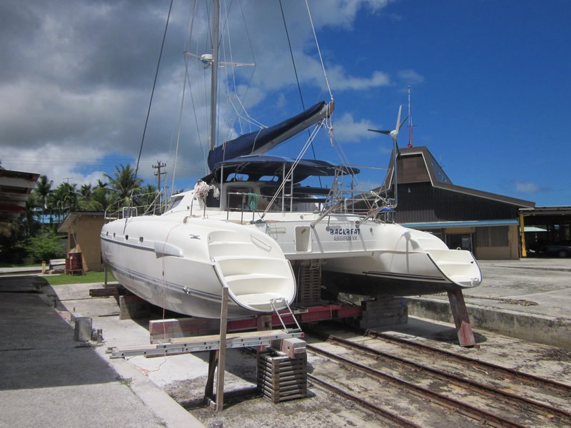
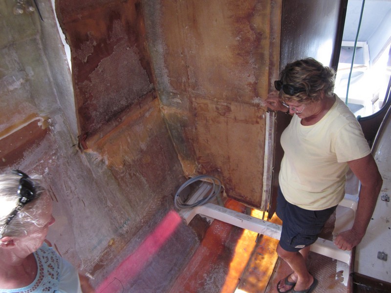
Backbeat Hauled Out in Yap
After lunch, we stopped in to say hello to Backbeat, a catamaran on the haulout ramp. We had heard of Backbeat when they went aground in Woleai last December when Typhoon Haiyan passed over... a huge saga.
They were fine, and the boat MOSTLY intact... except the keel running along one hull snapped sideways and made a major hole the length of the keel. They are designed as breakaway keels, but I guess it didn't break away cleanly.
After a couple of months making temporary repairs in Woleai, they were towed to Yap. But during the 2-3 day trip from Woleai, the leaks increased to the point where the boat was basically being towed underwater. So the entire interior, including engines and generator, is a total loss. By the end of it all, they have their bare hull (with some signficant issues), and a pretty good rig, and their lives.

Stripped Out Inside, Repairing the Keel
They are stuck here is sleepy Yap until they can get their boat sound enough (and at least one engine working) to move to someplace else--probably the Philippines, which are only about 5-7 days downwind--to complete their re-fit.
Marie from Backbeat was kind enough to load us up in her air conditioned car and give us the nickel tour of Yap, with quick stops in all 3 primary grocery stores to pick up what veggies we could find.
We'll be here for a week or two, experiencing Yap, and then on to Palau if the wind ever comes back.
-----
At 04/28/2014 7:00 AM (utc) our position was 09°30.86'N 138°07.35'E
We called the Port Captain on VHF on our way in, and made arrangements to meet the officials on shore at 11am. When we got there a few minutes late, John, the Port Captain representative was the only one there. He put us in his air conditioned pickup and drove us 100 yards to the air conditioned Immigration office (across from the Marina Restaurant). There we were waved into a chair and proceeded to meet 6 different officials to complete our check-in (Port, Immigration, Customs, Quarantine, Health, EPA). Quite a lot of paperwork for such a small island, and especially considering we've been in their country for almost 3 months already.
There was a question about our holding tank capacity--as usual, everyone wants you to have a holding tank, but nobody has the facilities to pump it out. We told them we'd be using the facilities ashore. Which, I am absolutely positive, DON'T go to a sewage treatment plant, but probably just a septic tank and then into the water (if it is a recently-built modern structure).
Also the quarantine guy wanted us to keep all our "garbage" (wet trash) aboard. But literally EVERYTHING (fruits and vegs) we have onboard were purchased in the FSM. They just don't get the difference between a cruising yacht and a big ship.
The EPA guy had a form for us to fill out about what fuel and other possible contaminants we had on board--in case we went aground or sunk, so they knew how to clean up our spill site. Methinks they've been training too much in the U.S. In contrast, I've seen guys in the islands just toss an outboard motor oil plastic container over the side when they were finished topping off their tank.
Anyway, everyone was friendly and fairly efficient. We hadn't brought enough copies of our crew list, but the Immigration lady kindly made a couple of copies for us. By 11:45 we were finished, and Dave and I went to lunch at the Marina Restaurant (no Marina to go with the Restaurant, but a nice view of our boat on anchor).
After lunch, we stopped in to say hello to Backbeat, a catamaran on the haulout ramp. We had heard of Backbeat when they went aground in Woleai last December when Typhoon Haiyan passed over... a huge saga.
They were fine, and the boat MOSTLY intact... except the keel running along one hull snapped sideways and made a major hole the length of the keel. They are designed as breakaway keels, but I guess it didn't break away cleanly.
After a couple of months making temporary repairs in Woleai, they were towed to Yap. But during the 2-3 day trip from Woleai, the leaks increased to the point where the boat was basically being towed underwater. So the entire interior, including engines and generator, is a total loss. By the end of it all, they have their bare hull (with some signficant issues), and a pretty good rig, and their lives.
They are stuck here is sleepy Yap until they can get their boat sound enough (and at least one engine working) to move to someplace else--probably the Philippines, which are only about 5-7 days downwind--to complete their re-fit.
Marie from Backbeat was kind enough to load us up in her air conditioned car and give us the nickel tour of Yap, with quick stops in all 3 primary grocery stores to pick up what veggies we could find.
We'll be here for a week or two, experiencing Yap, and then on to Palau if the wind ever comes back.
-----
At 04/28/2014 7:00 AM (utc) our position was 09°30.86'N 138°07.35'E
Monday, April 28, 2014
A Few Days at Ulithi Atoll
We ended up having to turn on the engine about 30 miles out of Ulithi, to make sure we made it in to an anchorage before dark. We crossed over Zohhoiiyoru Bank on our approach. The water depth goes from several thousand meters deep to 30 feet, for half a mile, and back to deep again. So we put the fishing lines out, but got nary a nibble, over the bank, up the slot, and into the atoll. We did see two different sets of mating turtles though, out near the islands at Z-- Bank. Amazing that there are any turtles left at all here--the Micronesians have no concept of turtle conservation, and they're all going to be gone soon.

Soggy Paws Anchored Off Sorlen Island
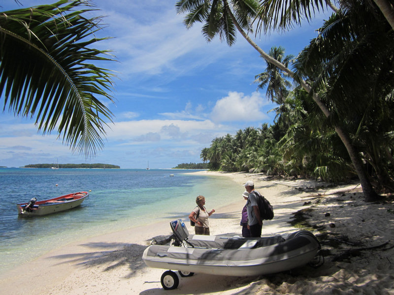
We arrived in Ulithi late in the day on Thursday, and dropped anchor off Sorlen Island just before sunset. We chose this spot partly because of its protection from tne NE winds, but also because it was NOT one of the "inhabited islands". After a week at Woleai doing the village thing, we were ready for a break and some time to ourselves. I picked the anchoring spot off Google Earth, and it turned out to be as nice as it looked from space... nice big sand area in about 25 feet, and off a pretty sand beach.
In spite of all my worries about the weather--there was a "low level circulation" to the SE of us, meandering NW towards us--the weather turned out pretty good for our whole stay. The Low scooted off toward Guam this morning without bringing us any bad weather.
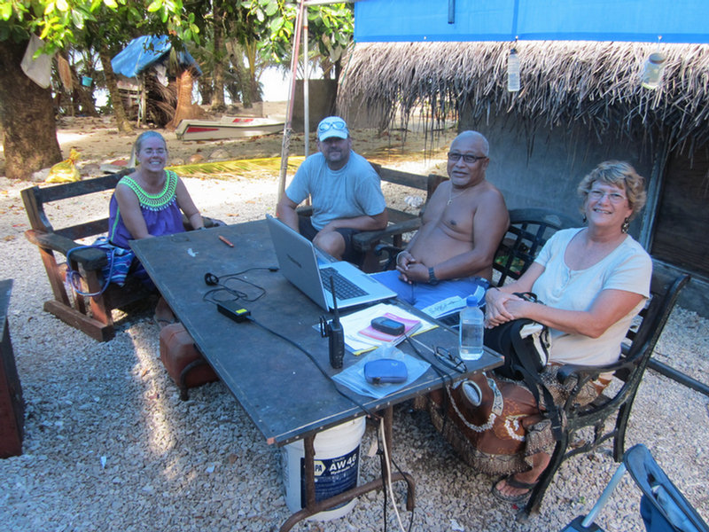
Since no other cruisers we knew about had gone to Mog Mog Island, we had to figure it our for ourselves. Friday morning, Dave got on the VHF radio and called "Mog Mog Island, Mog Mog Island." After a couple of calls, someone actually answered us back! This turned out to be Stanley, who is the official "greeter" for Mog Mog. (Note, the locals pronounce it more like "Mo Mo").
Dave asked permission for us to come and anchor at their island and come ashore, and get a tour around. When we arrived in front of Mog Mog, Stanley was waiting for us on the beach. Stanley turned out to be similar to Matthais at Woleai--he had grown up on Mog Mog, and ended up in government service in Yap. He had recently retired from his job as liaison for the Yap Governer, and was enjoying the slow pace of life back on his home island.

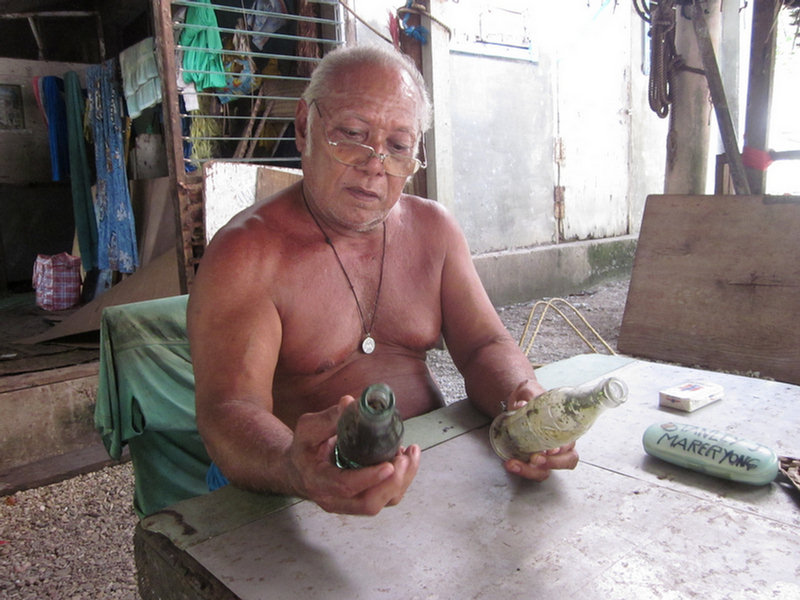
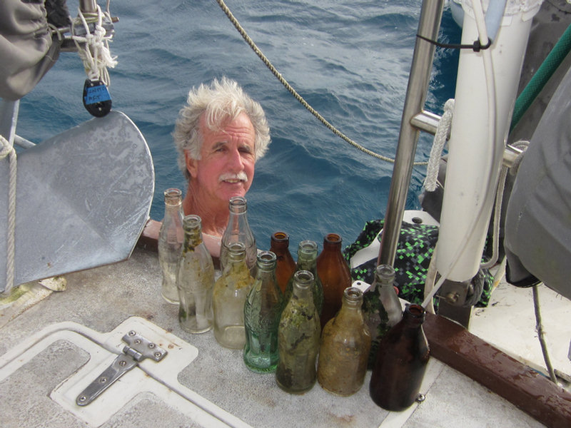
Stanley Checking Out Dave's Coke Bottles
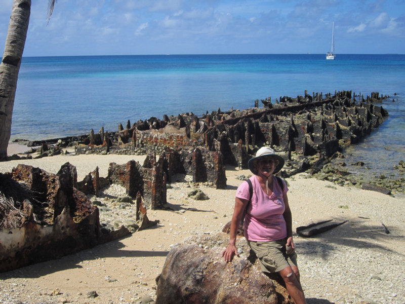
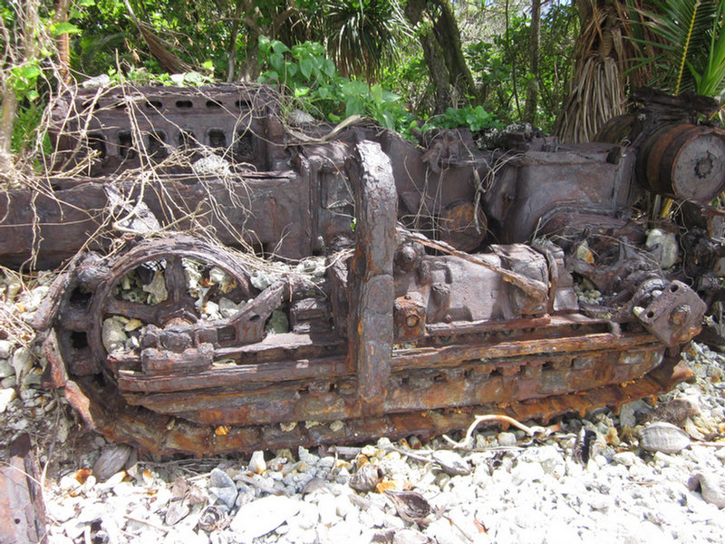
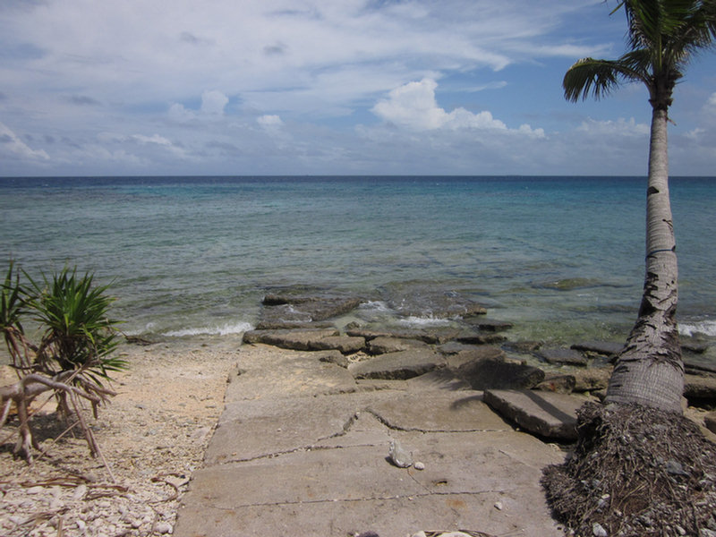
We kept waiting for Stanley to ask for paperwork, or money, but he did neither--a pleasant surprise. Dave asked if he could get a tour of the island--specifically the former US Navy facilities. Stanley opted to take us himself. He told Dave up front that there wasn't much to see--and he was right. In the 70 years since the fleet was in Ulithi Atoll, between time, typhoons, and scavenging locals, there was almost nothing left of the old facilities, besides the rusting remnants of piers we had seen on our way in.

The "Officer's Pier"
Stanley told us that one pier was for officers and one for enlisted men. We saw the remains of a seaplane ramp--a few flat bits of concrete. But where the old hospital was (according to Stanley), there was nothing left. Stanley walked us nearly all the way around the small island, on the old "Navy Road", which is now more like a wide path than a road.

Sherry & Stanley on the Old Navy Road

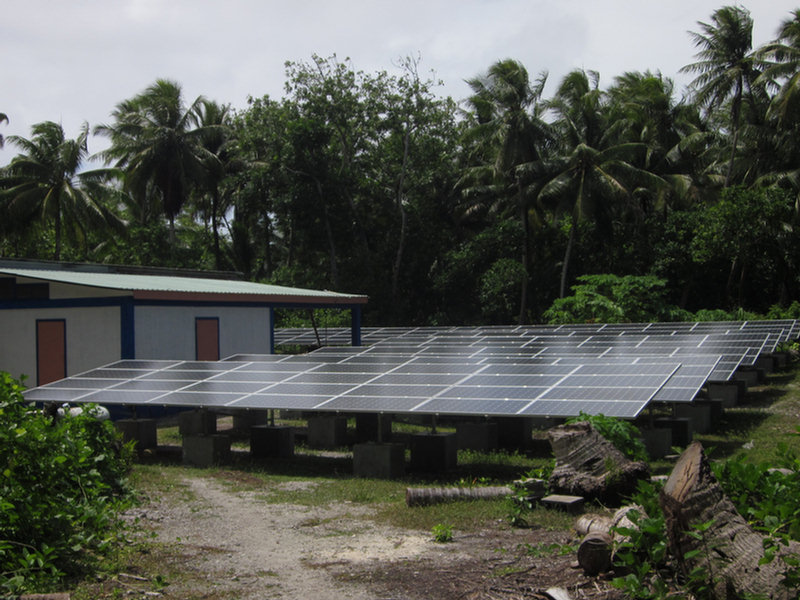
Mog Mog's New Solar System

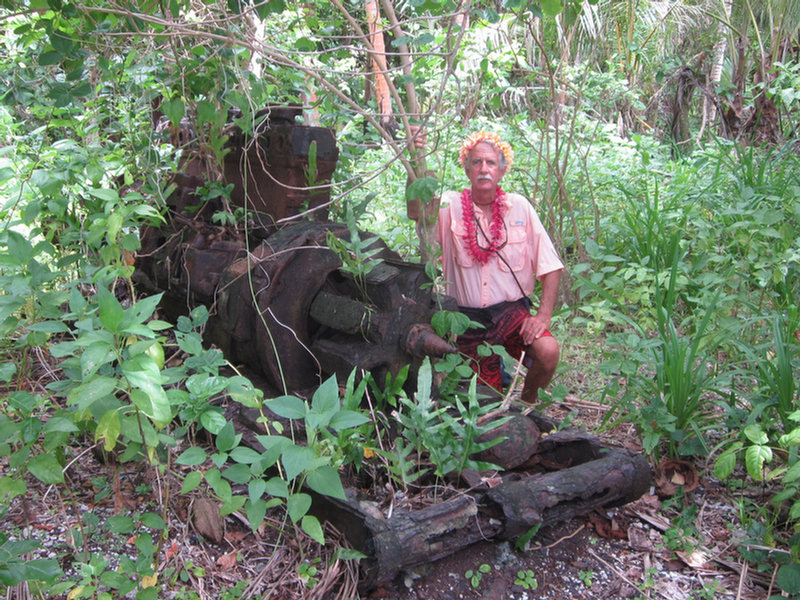
Remnants of the American Presence

More Old Machines

Seaplane Ramp
Another request that Dave had was "old Coke bottles". He had heard from someone that Ulithi, like Majuro, having been a big R&R facility during the war, had old Coke bottles laying around. Stanley took us to the former dump (now their taro patch), and we rooted around in the dirt and found a couple of 1944 Coke bottles (the month and year that the bottle was made is stamped on the bottle). Dave has been contacted by a friend of a friend who's an executive with Coca Cola in Atlanta who asked for a couple of old bottles for their collection.

Dave and His 1944/1945 Coke Bottles

The Women's Meeting House on Mog Mog (Prohibited to Men)
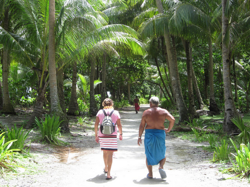
The wind came up in the afternoon, more easterly than forecast, so the anchorage off Mog Mog wasn't very good. We motored the short distance back to Sorlen and enjoyed another quiet night by ourselves there. Before we left Mog Mog, Dave asked Stanley for permission to go ashore on Sorlen. Stanley said that island didn't belong to Mog Mog, but he would ask someone who could give us permission. The next morning Stanley called us on VHF to say we could go ashore.
There is another old metal pier at Sorlen, and just inshore of that, a concrete building that looked like someone's home, now abandoned. There was a nice grave next to the house with lots of flowers on it. We spent the morning poking around the beaches of Sorlen, looking for World War II era traces. There were hunks of metal in various spots off the beach--mostly unidentifiable. And there were a few concrete pads we found. Dave found a couple of bullets and shell casings of various sizes embedded in the coral on the rocky shore. We checked a portion of the windward beach to see if there were any glass balls there, but found nothing but lots of abandoned shoes, plastic bottles, and fishing floats of various sizes and configurations.
We also saw a 3-foot monitor lizard run out of the dense coconut palm thicket, down the beach and into the water. Dave tried to get a picture of it on its way back up the beach, but we're not sure how well it came out.
We had a nice steak and baked potato dinner for Dave's birthday, and really enjoyed watching the sunset in the solitude of the Sorlen anchorage.
Dave went back to Mog Mog to say goodbye to Stanley (and return a book he had lent us on Micronesia). He took 2 big bunches of bananas with him--as usual, all the bananas we had been given in Woleai when we left came ripe at once, and there was no way we'd be able to eat them. He had fun handing out bananas on the beach to the kids. Stanley also appreciated the gifts of cigarettes, coffee, AA batteries, and a few fishhooks Dave gave him. Plus Dave took a few paperbacks in for one of the men who'd asked us for reading material the day before.
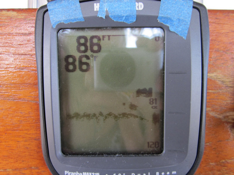
This morning, we up-anchored from our pretty little anchorage at Sorlen and headed south inside the atoll to check out the wreck site of the USS Mississinewa. This ship was torpedoed by a Japanese "manned torpedo" (or mini-sub) while at anchor in Ulithi on 20 November 1944. We had 3 different waypoints for the ship--one from Wikipedia, one from a US Navy report, and one indicated on our CM93 chart. Arriving in the area, we motored around the 3 waypoints (close but not on top of each other) and were very surprised to find that the one from the chart was the correct waypoint. Once we found the ship (using our fishfinder depthsounder, we could see it's profile as we went over it), we looked up and said, "Hey, there's a bouy!". Duh. It wasn't a very big buoy, so it was easy to miss until we were right on top of it.

Finding the Mississinewa Using Our Fishfinder

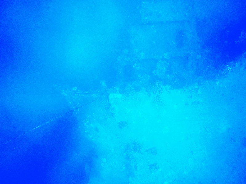
Dave's Snorkel Picture of the Mississinewa Bow
I tried to get Dave interested in making a short dive on the Mississinewa while I waited onboard Soggy Paws (without anchoring), but he thought that was too risky. So he jumped in with mask and fins and snorkel and just looked at it from snorkel depths. He could clearly see the bow section about 70 feet below him. He took a picture. That was good enough to say "mission accomplished" on that one.
We left by one of many breaks in the reef on the west side of the atoll at 10am this morning, and are on our way to Yap right now (ETA tomorrow morning).
All our anchoring, pass, and wreck waypoints are written up in our Micronesia Compendium, if you are interested in details.
-----
At 04/27/2014 10:39 AM (utc) our position was 09°51.63'N 139°04.62'E
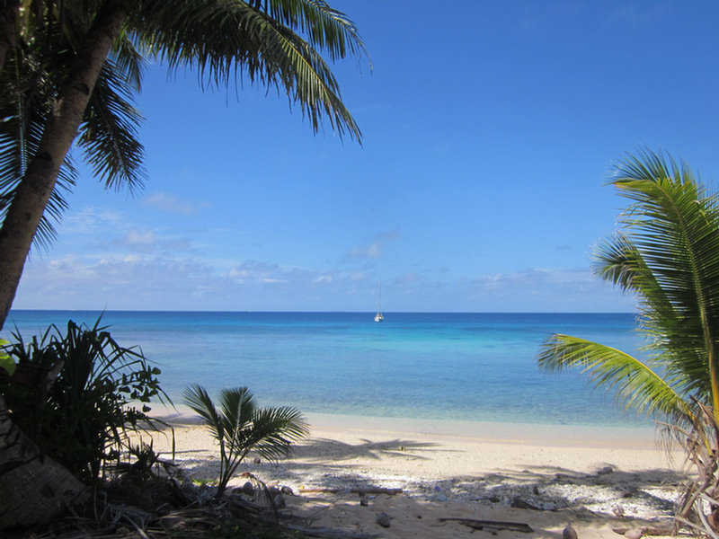
We arrived in Ulithi late in the day on Thursday, and dropped anchor off Sorlen Island just before sunset. We chose this spot partly because of its protection from tne NE winds, but also because it was NOT one of the "inhabited islands". After a week at Woleai doing the village thing, we were ready for a break and some time to ourselves. I picked the anchoring spot off Google Earth, and it turned out to be as nice as it looked from space... nice big sand area in about 25 feet, and off a pretty sand beach.
In spite of all my worries about the weather--there was a "low level circulation" to the SE of us, meandering NW towards us--the weather turned out pretty good for our whole stay. The Low scooted off toward Guam this morning without bringing us any bad weather.
Since no other cruisers we knew about had gone to Mog Mog Island, we had to figure it our for ourselves. Friday morning, Dave got on the VHF radio and called "Mog Mog Island, Mog Mog Island." After a couple of calls, someone actually answered us back! This turned out to be Stanley, who is the official "greeter" for Mog Mog. (Note, the locals pronounce it more like "Mo Mo").
Dave asked permission for us to come and anchor at their island and come ashore, and get a tour around. When we arrived in front of Mog Mog, Stanley was waiting for us on the beach. Stanley turned out to be similar to Matthais at Woleai--he had grown up on Mog Mog, and ended up in government service in Yap. He had recently retired from his job as liaison for the Yap Governer, and was enjoying the slow pace of life back on his home island.
We kept waiting for Stanley to ask for paperwork, or money, but he did neither--a pleasant surprise. Dave asked if he could get a tour of the island--specifically the former US Navy facilities. Stanley opted to take us himself. He told Dave up front that there wasn't much to see--and he was right. In the 70 years since the fleet was in Ulithi Atoll, between time, typhoons, and scavenging locals, there was almost nothing left of the old facilities, besides the rusting remnants of piers we had seen on our way in.
Stanley told us that one pier was for officers and one for enlisted men. We saw the remains of a seaplane ramp--a few flat bits of concrete. But where the old hospital was (according to Stanley), there was nothing left. Stanley walked us nearly all the way around the small island, on the old "Navy Road", which is now more like a wide path than a road.
Another request that Dave had was "old Coke bottles". He had heard from someone that Ulithi, like Majuro, having been a big R&R facility during the war, had old Coke bottles laying around. Stanley took us to the former dump (now their taro patch), and we rooted around in the dirt and found a couple of 1944 Coke bottles (the month and year that the bottle was made is stamped on the bottle). Dave has been contacted by a friend of a friend who's an executive with Coca Cola in Atlanta who asked for a couple of old bottles for their collection.
The wind came up in the afternoon, more easterly than forecast, so the anchorage off Mog Mog wasn't very good. We motored the short distance back to Sorlen and enjoyed another quiet night by ourselves there. Before we left Mog Mog, Dave asked Stanley for permission to go ashore on Sorlen. Stanley said that island didn't belong to Mog Mog, but he would ask someone who could give us permission. The next morning Stanley called us on VHF to say we could go ashore.
There is another old metal pier at Sorlen, and just inshore of that, a concrete building that looked like someone's home, now abandoned. There was a nice grave next to the house with lots of flowers on it. We spent the morning poking around the beaches of Sorlen, looking for World War II era traces. There were hunks of metal in various spots off the beach--mostly unidentifiable. And there were a few concrete pads we found. Dave found a couple of bullets and shell casings of various sizes embedded in the coral on the rocky shore. We checked a portion of the windward beach to see if there were any glass balls there, but found nothing but lots of abandoned shoes, plastic bottles, and fishing floats of various sizes and configurations.
We also saw a 3-foot monitor lizard run out of the dense coconut palm thicket, down the beach and into the water. Dave tried to get a picture of it on its way back up the beach, but we're not sure how well it came out.
We had a nice steak and baked potato dinner for Dave's birthday, and really enjoyed watching the sunset in the solitude of the Sorlen anchorage.
Dave went back to Mog Mog to say goodbye to Stanley (and return a book he had lent us on Micronesia). He took 2 big bunches of bananas with him--as usual, all the bananas we had been given in Woleai when we left came ripe at once, and there was no way we'd be able to eat them. He had fun handing out bananas on the beach to the kids. Stanley also appreciated the gifts of cigarettes, coffee, AA batteries, and a few fishhooks Dave gave him. Plus Dave took a few paperbacks in for one of the men who'd asked us for reading material the day before.
This morning, we up-anchored from our pretty little anchorage at Sorlen and headed south inside the atoll to check out the wreck site of the USS Mississinewa. This ship was torpedoed by a Japanese "manned torpedo" (or mini-sub) while at anchor in Ulithi on 20 November 1944. We had 3 different waypoints for the ship--one from Wikipedia, one from a US Navy report, and one indicated on our CM93 chart. Arriving in the area, we motored around the 3 waypoints (close but not on top of each other) and were very surprised to find that the one from the chart was the correct waypoint. Once we found the ship (using our fishfinder depthsounder, we could see it's profile as we went over it), we looked up and said, "Hey, there's a bouy!". Duh. It wasn't a very big buoy, so it was easy to miss until we were right on top of it.
I tried to get Dave interested in making a short dive on the Mississinewa while I waited onboard Soggy Paws (without anchoring), but he thought that was too risky. So he jumped in with mask and fins and snorkel and just looked at it from snorkel depths. He could clearly see the bow section about 70 feet below him. He took a picture. That was good enough to say "mission accomplished" on that one.
We left by one of many breaks in the reef on the west side of the atoll at 10am this morning, and are on our way to Yap right now (ETA tomorrow morning).
All our anchoring, pass, and wreck waypoints are written up in our Micronesia Compendium, if you are interested in details.
-----
At 04/27/2014 10:39 AM (utc) our position was 09°51.63'N 139°04.62'E
Thursday, April 24, 2014
Enroute to Ulithi Atoll
All our friends (Kokomo, Westward II, and La Gitana) headed west toward Palau when we left Woleai. But Dave is on a mission to see as much of the World War II history of Micronesia as he can. So we are headed for Ulithi Atoll. Ulithi was a major staging area for U.S. ships just before the two big battles for the Philippines (late 1944 and early 1945).
Here is what we've garnered off the internet about Ulithi: The atoll is composed of 49 islands, only four of which – Falalop, Mogmog, Asor and Fassarai – are inhabited. Total population is approximately 700. Of the atoll's 209-square mile lagoon, total landmass of the 49 islands is only 1.75 square miles. As usual, Wikipedia has a great writeup on Ulithi. Here are a couple of excerpts:
"Within a month of the occupation of Ulithi, a complete floating base was in operation. Six thousand ship fitters, artificers, welders, carpenters, and electricians arrived aboard repair ships, destroyer tenders, and floating dry docks. The USS Ajax had an air-conditioned optical shop and a metal fabrication shop with a supply of base metals from which she could make any alloy to form any part needed. The USS Abatan, which looked like a big tanker, distilled fresh water and baked bread and pies. The ice cream barge made 500 gallons a shift. The dry docks towed to Ulithi were large enough to lift dry a 45,000 ton battleship. The small island of Mog Mog became a rest and recreation site for sailors.
The Seabees completed a fleet recreation center at Mog Mog island that could accommodate 8,000 men and 1,000 officers daily. A 1,200-seat theatre, including a 25-by-40-foot stage with a Quonset hut roof was completed in 20 days. At the same time, a 500-seat chapel was built. A number of the larger islands were used both as bases to support naval vessels and facilities within the lagoon.
By March 13 there were 647 ships at anchor at Ulithi, and with the arrival of amphibious forces staging for the invasion of Okinawa the number of ships at anchor peaked at 722."
http://en.wikipedia.org/wiki/Ulithi
Unfortunately, for a sailing yacht, Ulithi doesn't offer much protection. So we are only planning to stay a day or two, and then move on to the fully-protected harbor at Yap, another 100 miles SW of Ulithi. Dave wants to stop at Mog Mog, and maybe we'll try to dive the USS Mississinewa, a US ship that was sunk by a Japanese manned (ie Kamikaze) torpedo.
Once we get to Yap, we'll only be able to stay a week or so there, as we've scheduled SSCA-sponsored Ham Exams in Palau (a 2-3 day sail from Yap) on May 24th.
We have about 30 miles to go to the pass at Ulithi--as long as the wind holds, we should make it there before sunset today.
-----
At 04/24/2014 12:08 AM (utc) our position was 09°47.58'N 140°10.22'E
Tuesday, April 22, 2014
Woleai Arrival
April 16-18
We arrived in Woleai the Wednesday before Easter, having had to motor the final 12 hours in almost no wind. What a gorgeous place!

The Beautiful Beach at Woleai
Our friends on Westward II and Kokomo have been at Woleai for a couple of weeks--stuck there by the light winds and westerly winds. So they already knew the whole village, and quickly introduced us around.

Checking In with Matthias
First, we checked in with Matthias, who is the official "greeter" for Woleai. Matthias is recently retired from a government (marine division) job in Pohnpei, the capital of FSM. He has a nice "office" set up under an awning next to his house (a thatched-roof traditional building with detached cooking area).
Matthias's wife, Joanna, has been helping Selena from Westward II weave a traditional women's "lava lava" (wrap-around skirt). This is done the old fashioned way--with a backstrap loom, by hand. The lava lava, with belt is the ONLY traditional wear for women on Woleai. Yep, they go topless. The men wear a sarong wrapped around their waist and between their legs while working in the taro fields, while fishing, while swimming. On Woleai, the men's sarongs don't expose the buttocks, but the little boys' sarongs have their cheeks hanging out, which is just so cute.

Chief Francis (with the sunglasses we gave him)
Matthias had set us up an audience with the two primary chiefs of the village--both men named Francis. The paramount chief is a lively 79-year old with a quick wit and a ready smile. He is totally blind, so he was led to the meeting by his son, a big strapping handsome man. Francis understands English well, but prefers to speak Woleain and have Matthais translate for him. We met in the chief's "boathouse", a large open-air thatch-roofed building that is essentially where the men of his clan hang out (and where they store boat parts, fishing gear, and fish traps, and work on their canoes). In general, women are prohibited from the boathouse, though they make an exception in certain circumstances for visiting yachties.
Woleai has a tiny hospital (aka dispensary), an elementary school, and a high school. This is the primary high school for all the islands surrounding Woleai atoll. We were amazed to find out that the dispensary has recently been equipped with a satellite internet system, with wifi. This is compliments of the Japanese government. The wifi was made available to us yachties for an astoundingly low fee of $5. It was slow, but usable, and enabled us to catch up on a few critical items (Facebook, blogs of our friends, bill paying, etc).
Stephen and Selena had been there long enough that they had been asked to do several talks at the schools about Australia, New Zealand, and where they'd been in their travels. They had also done at least one Movie Night on the grounds in front of the church. So they were totally plugged into the local scene.

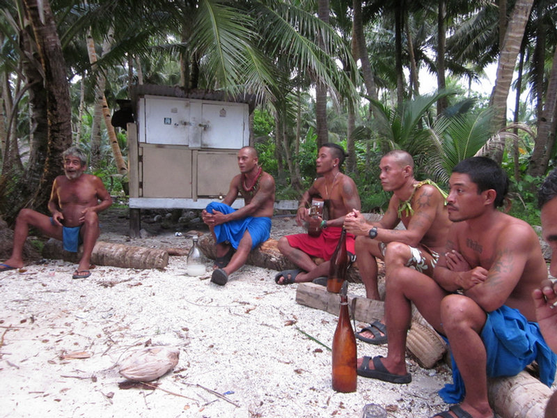
A Special Invite to the Cruiser Ladies to Drink Tuba
One huge aspect of the local scene for men is the evening "tuba circles". Tuba is a drink made by tapping a coconut palm. It is collected in an empty coconut that has naturally occurring yeast in it. This juice, by evening, makes a potent alcoholic beverage.

The Men in Their Nightly Tuba Circle
So the men gather near their boathouse, in a circle, and pass around the Tuba. (also known as Faluba in this part of FSM). The making, collecting, and drinking of tuba is fairly regulated by the council of elders, to keep things from getting out of hand. The men from our 4 boats went to several tuba circles. Dave, and Peter from Kokomo, didn't like the taste, and so took along mixers for their tuba. But Stephen and VK from La Gitana liked the traditional way, from a passed-around coconut shell. The yachtie women were invited to participate in Matthais's circle one evening. Normally I'm up for anything alcoholic, but I didn't like tuba. But for the islanders (and yachties who didn't provision well enough and are out of alcohol), the price is right and it can be very intoxicating.

Dave Choking Down His Tuba
Since Woleain is the 4th different language in 4 stops, we never even picked up a word of it. Fortunately enough of the people speak pretty good English that we could get along OK.
Unlike Chuuk, where no one on the entire (large, populated) atoll seemed to own or use a VHF, everyone in Woleai uses one... both for the "safety while at sea" reason, but also as a party line for communications. We and they quickly learned each other's callsigns, and it was nice being able to contact people by radio. This was one of the items the yachties were asked for, and each of the other 3 boats ended up selling a hand-held to someone on the island (I couldn't get Dave to part with ours).

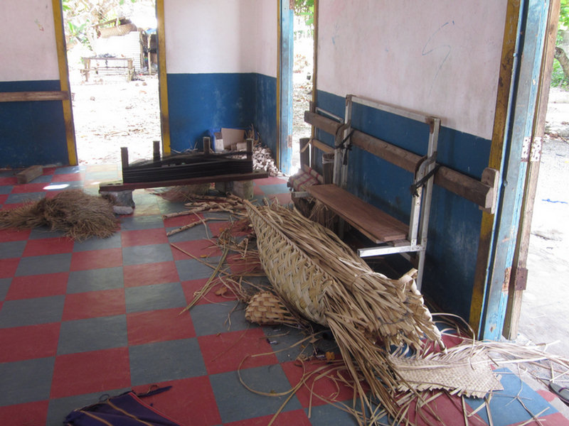
Sherry Sewing the Big Sail in the Men's Canoe House
One of the things we were asked to do while we were in Woleai was sew a sail for them. Apparently a politician running for office in the FSM gave a roll of good sailcloth to each clan on the Yap outer islands. I got volunteered by Stephen on Westward II--their sewing machine runs of 220v, and trying to rig up power for it would be a pain. Since we have a good sewing machine, it was impossible to refuse to at least try. So with Stephen assisting (Dave was out touring Japanese relics), I spent the day in the Chief's canoe house, sitting on a log, sewing a traditional canoe sail. The cloth was brand new 7oz Dacron, stiff and slippery. Fortunately, I had some double-sided tape to help stick the pieces together, or we'd have never gotten done.
The Chief's son did all the measuring and cutting (with a couple of coconuts and some "string" from a coconut leaf)--all we needed to do was sew the panels together. The first panel was 26 feet long!! But the 6th panel was only about 5 ft. It got to be quite a job to move the growing sail around, and we ended up with about 3-4 boys helping us out and another half dozen men and boys hanging around watching. They loved to see the needle fly. My sewing machine wasn't doing the best job--with occasional broken needles and frequent broken threads. But with two rows with V92 thread in each overlapping seam, it's probably sturdier and certainly a lot easier than them hand-sewing the whole thing. I was worried that the job would drag over into our weather window, but once I got all the panels sewn, my job was done. They would finish the edges--custom fitting it to the lateen rig, and hand-sewing the edges. Of course, the next clan down the island then approached me to sew THEIR sail, but we had to decline.
-----
At 04/16/2014 9:02 PM (utc) our position was 07°22.05'N 143°54.14'E
We arrived in Woleai the Wednesday before Easter, having had to motor the final 12 hours in almost no wind. What a gorgeous place!
Our friends on Westward II and Kokomo have been at Woleai for a couple of weeks--stuck there by the light winds and westerly winds. So they already knew the whole village, and quickly introduced us around.
First, we checked in with Matthias, who is the official "greeter" for Woleai. Matthias is recently retired from a government (marine division) job in Pohnpei, the capital of FSM. He has a nice "office" set up under an awning next to his house (a thatched-roof traditional building with detached cooking area).
Matthias's wife, Joanna, has been helping Selena from Westward II weave a traditional women's "lava lava" (wrap-around skirt). This is done the old fashioned way--with a backstrap loom, by hand. The lava lava, with belt is the ONLY traditional wear for women on Woleai. Yep, they go topless. The men wear a sarong wrapped around their waist and between their legs while working in the taro fields, while fishing, while swimming. On Woleai, the men's sarongs don't expose the buttocks, but the little boys' sarongs have their cheeks hanging out, which is just so cute.
Matthias had set us up an audience with the two primary chiefs of the village--both men named Francis. The paramount chief is a lively 79-year old with a quick wit and a ready smile. He is totally blind, so he was led to the meeting by his son, a big strapping handsome man. Francis understands English well, but prefers to speak Woleain and have Matthais translate for him. We met in the chief's "boathouse", a large open-air thatch-roofed building that is essentially where the men of his clan hang out (and where they store boat parts, fishing gear, and fish traps, and work on their canoes). In general, women are prohibited from the boathouse, though they make an exception in certain circumstances for visiting yachties.
Woleai has a tiny hospital (aka dispensary), an elementary school, and a high school. This is the primary high school for all the islands surrounding Woleai atoll. We were amazed to find out that the dispensary has recently been equipped with a satellite internet system, with wifi. This is compliments of the Japanese government. The wifi was made available to us yachties for an astoundingly low fee of $5. It was slow, but usable, and enabled us to catch up on a few critical items (Facebook, blogs of our friends, bill paying, etc).
Stephen and Selena had been there long enough that they had been asked to do several talks at the schools about Australia, New Zealand, and where they'd been in their travels. They had also done at least one Movie Night on the grounds in front of the church. So they were totally plugged into the local scene.
One huge aspect of the local scene for men is the evening "tuba circles". Tuba is a drink made by tapping a coconut palm. It is collected in an empty coconut that has naturally occurring yeast in it. This juice, by evening, makes a potent alcoholic beverage.
So the men gather near their boathouse, in a circle, and pass around the Tuba. (also known as Faluba in this part of FSM). The making, collecting, and drinking of tuba is fairly regulated by the council of elders, to keep things from getting out of hand. The men from our 4 boats went to several tuba circles. Dave, and Peter from Kokomo, didn't like the taste, and so took along mixers for their tuba. But Stephen and VK from La Gitana liked the traditional way, from a passed-around coconut shell. The yachtie women were invited to participate in Matthais's circle one evening. Normally I'm up for anything alcoholic, but I didn't like tuba. But for the islanders (and yachties who didn't provision well enough and are out of alcohol), the price is right and it can be very intoxicating.
Since Woleain is the 4th different language in 4 stops, we never even picked up a word of it. Fortunately enough of the people speak pretty good English that we could get along OK.
Unlike Chuuk, where no one on the entire (large, populated) atoll seemed to own or use a VHF, everyone in Woleai uses one... both for the "safety while at sea" reason, but also as a party line for communications. We and they quickly learned each other's callsigns, and it was nice being able to contact people by radio. This was one of the items the yachties were asked for, and each of the other 3 boats ended up selling a hand-held to someone on the island (I couldn't get Dave to part with ours).

One of the things we were asked to do while we were in Woleai was sew a sail for them. Apparently a politician running for office in the FSM gave a roll of good sailcloth to each clan on the Yap outer islands. I got volunteered by Stephen on Westward II--their sewing machine runs of 220v, and trying to rig up power for it would be a pain. Since we have a good sewing machine, it was impossible to refuse to at least try. So with Stephen assisting (Dave was out touring Japanese relics), I spent the day in the Chief's canoe house, sitting on a log, sewing a traditional canoe sail. The cloth was brand new 7oz Dacron, stiff and slippery. Fortunately, I had some double-sided tape to help stick the pieces together, or we'd have never gotten done.
The Chief's son did all the measuring and cutting (with a couple of coconuts and some "string" from a coconut leaf)--all we needed to do was sew the panels together. The first panel was 26 feet long!! But the 6th panel was only about 5 ft. It got to be quite a job to move the growing sail around, and we ended up with about 3-4 boys helping us out and another half dozen men and boys hanging around watching. They loved to see the needle fly. My sewing machine wasn't doing the best job--with occasional broken needles and frequent broken threads. But with two rows with V92 thread in each overlapping seam, it's probably sturdier and certainly a lot easier than them hand-sewing the whole thing. I was worried that the job would drag over into our weather window, but once I got all the panels sewn, my job was done. They would finish the edges--custom fitting it to the lateen rig, and hand-sewing the edges. Of course, the next clan down the island then approached me to sew THEIR sail, but we had to decline.
-----
At 04/16/2014 9:02 PM (utc) our position was 07°22.05'N 143°54.14'E
Wednesday, April 16, 2014
No Eclipse, but a Far Star
We eagerly watched for the Blood Moon eclipse at near sunset yesterday, but persistent squally weather in the area blocked everything out until it was all over.
Otherwise, we've had a decent overnight passage... light winds and easy sailing. However, we haven't been able to make either the course or speed we planned for. So at 7am this morning, we reluctantly pulled in the genoa and turned on the engine, so we get in to Woleai before dark (about 40 miles to go).
La Gitana, who left Olimarao a couple of hours after us, and has gone a little faster and pointed a little higher than us, is still sailing. Since Woleai has a fairly wide pass, and we have good Google Earth charts, they are planning to come in after dark.
Westward II and Kokomo have been in Woleai for nearly 2 weeks, waiting for enough wind to sail to Palau. Guess we'll all spend Easter together in Woleai, and then hope for a little wind.
 I want to send a huge CONGRATULATIONS to our friend Kennedy, on s/v Far Star, who just completed his single-handed Circumnavigation, by crossing his track in Grenada. We traveled in and out of company with Far Star for nearly a two years, and last shared an anchorage with Kennedy in Fiji. For the last year I've been saying, "If Kennedy, an early 60's retired lawyer in a 38 foot boat, can make it around South Africa by himself, we can too!!" Way to go, Kennedy!! Have a cold Caribe for us!!

Far Star
Otherwise, we've had a decent overnight passage... light winds and easy sailing. However, we haven't been able to make either the course or speed we planned for. So at 7am this morning, we reluctantly pulled in the genoa and turned on the engine, so we get in to Woleai before dark (about 40 miles to go).
La Gitana, who left Olimarao a couple of hours after us, and has gone a little faster and pointed a little higher than us, is still sailing. Since Woleai has a fairly wide pass, and we have good Google Earth charts, they are planning to come in after dark.
Westward II and Kokomo have been in Woleai for nearly 2 weeks, waiting for enough wind to sail to Palau. Guess we'll all spend Easter together in Woleai, and then hope for a little wind.
 I want to send a huge CONGRATULATIONS to our friend Kennedy, on s/v Far Star, who just completed his single-handed Circumnavigation, by crossing his track in Grenada. We traveled in and out of company with Far Star for nearly a two years, and last shared an anchorage with Kennedy in Fiji. For the last year I've been saying, "If Kennedy, an early 60's retired lawyer in a 38 foot boat, can make it around South Africa by himself, we can too!!" Way to go, Kennedy!! Have a cold Caribe for us!!
Tuesday, April 15, 2014
Underway for Woleai
As much as we were enjoying having Olimarao all to ourselves, we are still anxious to keep moving west. So when a tenuous weather window presented itself, we jumped on it.
We left Olimarao this morning, with winds about 8kts WNW. We are headed for Woleai, 120 nm WSW. The winds are forecast to go a tiny bit more N of west, so we are hoping to be able to sail most of the way to Woleai, and then motor in when the winds drop again tomorrow.
So far, things have gone as planned, we are sailing with the engine off at about 4 knots, in mostly the right direction. Right now we've got 92 miles to go and 24 hours to get there before dark tomorrow. There is more wind now than we've seen in a week or so. If only it would go a little more north, then we'd have a beautiful sail on a full moon night.
-----
At 04/15/2014 6:18 AM (utc) our position was 07°31.68'N 145°25.98'E
http://svsoggypaws.com/currentposition.htm
Saturday, April 12, 2014
Stopping at Olimarao for a Couple of Days
The winds haven't been as forecast the whole trip. There has been a trough laying across all of western Micronesia, and the GRIB files just haven't been able to predict where the trough was going to go, and what the resulting wind was going to be. Instead of the forecast E 10-12 we have had winds all over the map, and very unsettled weather. We thought we would be able to sail slowly the first 2 full days, then probably have to motor in the last 50 miles. But instead we were having to motor frequently when the wind dropped to zilch.
Then yesterday afternoon the wind switched to strong WSW--right in our face. We had a fall-back plan--fall off and head WNW to intermediate atolls of Lamotrek or Olimarao, and wait for the winds to change. Fortunately the wind eased to 8-10 knots and eventually swung around to the north. We had a beautiful calm sail all night long. Other than 3 hours of drizzle (but no accompanying violent weather), it was a perfect overnight sail.
Lamotrek was too close to stop--we passed it in the middle of the night. Olimarao was a bit further, and we arrived off the pass around 8am. It is an uninhabited satellite atoll of Lamotrek--the men from Lamotrek come up here periodically to fish, but no one is permanently based here. (So we don't have to do the "village" la-di-da--something that gets tiring after two or three of them in a row).
Our friends on La Gitana have been here a week--with VK laid up with an infection on his foot. We have been following their tracks, and talking with them on the radio for the past two years, but have never met them. So we thought we'd pop in to Olimarao to socialize for a couple of days. We'll poke around here, get a couple of nights good sleep (we hope!) and then move on.
The winds for the next week across the whole region are forecast to be light--5-8 knots most of the time. In a couple of days, they are forecast turn NW-W again, and then we may get a decent light-air sail for the next 120 mile hop to Woleai (slightly south of west).
Some sailors would opt to wait for more wind, with no chance of having to motor. But given the choice, we'd much prefer to go in light air, and motor if we have to, than go in the heavy wind and seas. On this last trip of ~200 miles, which lasted 50 hours duration, we motor-sailed about 17 hours. Our fuel consumption while motor-sailing "easy" is about .6-.8 gallons per hour. So we burned about 10 gallons of diesel to go 200 miles in easy conditions. We'll take it. We have plenty of fuel to motor all the way to Yap, if we have to. And we can top off in Yap without too much trouble. Fuel out here in the major cities is around $5-$5.50 per gallon--not cheap, but cheaper than trying to acquire some in the outer atolls, where we were quoted $10-$11/gallon, if it's available.
-----
Sherry & Dave
Heading west across Micronesia in 2014
http://svsoggypaws.blogspot.com
At 04/12/2014 2:24 AM (utc) our position was 07°42.04'N 145°52.80'E
http://svsoggypaws.com/currentposition.htm
Thursday, April 10, 2014
Underway from Puluwat Westward
Watching the weather has been aggravating the last few days. The forecast changes radically every 6 hours. But at least we were in a nice protected location. We had a couple of nice days, but also several squally blustery days. One weather window we let go by, because the forecast the day before had looked ugly, and we'd committed Dave to fixing someone's water tank in the village. When the day dawned sunny and with the right winds, we weren't ready to leave.
We finally opted to leave this morning in light winds in an iffy window. However, there's no better window in the works in the next week. It looks like the ITCZ (or something similar) is hanging right over 7N in western Micronesia. Waiting another couple of days may bring westerly winds. So we opted to go in light easterlies in somewhat still-unsettled weather.
So far, in the 7 hours we've been underway, we have seen wind from the East, South, and North. There is a really weak low hanging around with light circulating winds. I think we just sailed through the north edge of it. So we are motorsailing right now, trying to see what the wind is going to do before making yet another huge sail change.
It's 300 miles to Woleai, our primary destination. But we go right past Lamotrek in 150 miles, and there are two other smaller atolls between Lamotrek and Woleai, so if things get ugly unexpectedly, we have several places we could duck in.
-----
Sherry & Dave
Heading west across Micronesia in 2014
http://svsoggypaws.blogspot.com
At 04/10/2014 5:29 AM (utc) our position was 07°21.59'N 148°39.42'E
http://svsoggypaws.com/currentposition.htm
Thursday, April 3, 2014
Passage from Chuuk to Puluwat
By the time we got checked out from Chuuk and ready to go, the weather forecast had changed drastically for our trip. When we had set our departure date, the winds had been forecast at about 10 knots. By the time we left, the forecast was for 20+ knots!!
Had we been in Pohnpei, a harbor with very good protection and much easier communication with the officials, we would have stayed a couple of days and waited for a better window. But Chuuk isn't the best place to be if the weather deteriorates. AND the text forecast we got at the same time as the GRIB file, was more optimistic about the forecast. At the time there was a tropical depression forming to the east of Chuuk, forecast to drift slowly WNW. We wanted to beat it to Puluwat, which has a better anchorage for weird winds. Since supposedly, a weather forecaster creates the text forecast from the machine-generated GRIB forecast, we opted to believe their forecast over the GRIB files.
Turns out, this time at least, that the GRIB file was more accurate.
We left Chuuk in fairly pleasant conditions, and were congratulating ourselves on the decision to go, right up until about 1am, when the wind (as forecast by the GRIB files) started to pick up. Our "Genoa only, on a pole" sail plan, which was OK when the winds were 10 knots, turned out to be terrible (for steering) when the winds got up to 20 knots. Neither the wind vane nor the autopilot was very good in the windy conditions with large waves going down wind, with only the single headsail out, at least on the heading we were trying to make. Had we had a wing-on-wing configuration with either the mainsail or staysail on the opposite from the genoa, it would have been better. But we don't do sailhandling in the middle of the night in rough conditions if we can avoid it. So we just gutted it out and hand-steered when forced to, when the wind got up.
At dawn it was obvious that we had the GRIB-forecast conditions, not the text forecast conditions. As best we could tell without a real-time satellite photo, the depression had moved west and was nearly at our same latitude but 150 miles south of us. We had about 20-22 knots steady with gusts a little higher when the squalls went past. The seas had built to about 6-8 feet and were pushing the stern around a lot, making the steering situation even worse. (Overall, these are not terrible conditions, we just normally don't choose to go out in weather like this if we can help it).
We finally rolled in the genny to "squall size" and turned on the engine to help steady out the steering. We also pulled out the staysail, sheeted in hard on the other side, to help with the roll. By now the winds had gone east far enough that we were going dead down wind. Had we been on a longer passage, we would have adjusted our sail plan and/or angled off to a heading (temporarily) that would be easier for the steering.
The engine helped a lot for the steering, but I hated to be running the engine when we (finally) had some wind. It also helped us pick the speed up some. We wanted to get in AS SOON AS POSSIBLE. At that point, we were both pretty tired--not much sleep during the night, on or off watch, in those conditions.
On the approach to Puluwat, there is a couple of shoal areas, which I was worried about. The CM93 chart is vague, with few soundings, and the Google Earth chart is "air brushed" out in part of the area. Though the CM93 chart was fairly accurate in Chuuk, it's not accurate everywhere out here. So we got on the morning SSB net and asked about going over those banks in our current nasty weather. Fortunately we were assured that it would be OK. Others in previous weeks had come through there in similar conditions. So we headed straight for our waypoint at 07-20.5N / 149-11.8E just off the entrance to Puluwat's narrow channel.
Going over the banks I'd been worried about, we avoided the shallowest spot (30 feet on the charts, coming up abruptly from about 6000 feet), and so saw least depth of about 40 feet during the whole last 5 miles. But most of the time it was 150 feet or more, only occasionally rising to 60 feet and then dropping off again. I had worried about nasty washing machine seas with this variable bottom, but didn't notice the seas much worse near the banks.
The next thing I was worried about was having seas breaking across the channel. There isn't much protection from the big wind and seas until you get up inside the channel. The depths go from 150 feet to 40 feet to 20 feet in about 100 yards.
We had been warned that it was narrow, and it was! If I hadn't had good Google Earth charts, a good set of waypoints from friends, and assurances that others had come in in similar conditions, we might not have ventured in.
Dave was standing on our lookout position giving encouragement and directions, as I steered our way using the waypoints. One tiny end of a wave did break across the entrance, but we could see it wasn't bad. Fortunately we were between squalls, so visibility was reasonable, at noon, even with the overcast. One minute we were out in the storm, the next minute... ahhh... calm and quiet in a pretty little lagoon with a 25-30' deep sand bottom, and a sand beach. Very pretty and very quiet.
Our waypoints on the way in (from Kokomo) were:
07 20.624N 149 11.529E
07 20.745N 149 11.521E
07 20.802N 149 11.514E
07 20.867N 149 11.516E
07 20.917N 149 11.527E
07 20.982N 149 11.536E
07 21.270N 149 11.528E anchored here
We checked out Kokomo's anchor spot but it looked corally. Later we found that most (but not all) of the black spots on the bottom are grass and not coral. So their anchorage was OK. We anchored further south at 07-21.13N / 149-11.56E
Glad to be here. More on Puluwat later.
-----
Sherry & Dave
Heading west across Micronesia in 2014
http://svsoggypaws.blogspot.com
At 04/02/2014 3:25 AM (utc) our position was 07°21.11'N 149°11.54'E
http://svsoggypaws.com/currentposition.htm
Saturday, March 22, 2014
Safely in Chuuk--Diving!
We had an easy overnight passage, with steady winds from 10-15 knots almost square on the beam.

On a Mooring at Truk Stop Hotel and Dive Center
We went through one of the several passes on the SE side at 8:30am. The sun was rising behind us and we could see just fine. My original route had us taking a direct line into Weno, cutting between two big islands. But that track was strewn with various reefs, and our CM93 chart was of unknown reliability, and we didn't have a good Google Earth chart (we hadn't been coming here!). So we decided to take the longer route around. This added about 5 miles to our trip, and would mean that we'd get to the dock around 11:30, pushing it for a "no overtime" check-in.
We decided to slow down and arrive at 1pm. That way, there was little chance of anyone doing the "overtime game" on us. There are numerous horror stories about outrageous checkin fees and hassles at Chuuk. (It turned out that we could probably have easily navigated the trickier route--we had a very nice day and mild conditions).
From another cruiser who came before us (thanks, Trigger), we had the phone numbers of all the officials. And we had a cell phone from Pohnpei AND minutes. So Dave called each one and made an appointment for 1:30pm. The only official we couldn't get ahold of was the Port Captain. Normally, the Port Captain is the FIRST guy you call--usually on VHF. And normally, HE arranges all the other officials. However, Chuuk is different. It turns out that the Port Captain doesn't even have an office or a VHF. We had an office phone for him, but apparently it is disconnected. We had a cell phone number but we got "we are unable to reach this number". Dave called another of the officials back and asked if he could get ahold of the Port Captain for us, but they were not able to reach him either.
We docked at the big ship pier (high concrete docks, but with big rubber fenders) between two fishing boats, at 12:59. At 1:30, Customs and Health showed up, and a few minutes later, Immigration. Why we need so many officials on a "National" check-in, I don't know. But all wanted a copy of our paperwork, so I was hopping taking care of that while Dave schmoozed the officials. Thank GOD for our printer/copier scanner--I wouldn't go international cruising without one.
Within an hour, all our formalities were completed EXCEPT the Port Captain. Dave had one of the other officials try to call him again. And he asked the other two boats nearby, if they knew where he was. We had lots of onlookers--truck drivers and dock workers (a big ship had just departed after unloading a bunch of containers), but nobody knew where the Port Captain was. So we waited. Finally about 4:30, he shows up. We gave him some more copies, and he told us all the fees we'd have to pay on checking OUT. (a couple of $30's, then $25 for first 48 hrs and $10 per day after that). We knew about these already, so instead of gasping, Dave just smiled and said OK. It's a lot cheaper than flying here and staying in a hotel!
So we are now anchored off the Truk Stop Hotel in downtown Weno, Truk Lagoon, Federated States of Micronesia. 07-25.5N / 151-50.23E. We are taking a "land tour" this morning and then diving this afternoon. We actually found some fresh veggies yesterday in a supermarket--broccoli, carrots, lettuce, celery, onions, potatoes, cabbage. We didn't find any Lays (or similar) Potato Chips. Just funky Asian chips (chicken-flavored, and other weird tastes). But we're still looking.
Dave told the officials we'll be here two weeks--but really we'll stay until we are finished diving, and have had a couple of "land tour days" and a day to finish reprovisioning.
-----
At 03/20/2014 8:48 PM (utc) our position was 07°26.51'N 151°50.23'E
http://svsoggypaws.com/currentposition.htm
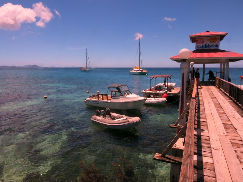
Thursday, March 20, 2014
On Passage to Chuuk
We had planned to (reluctantly) skip Chuuk (Truk Lagoon), because of all the bad things we have heard about it. We really wanted to go there to dive the wrecks, but it just seemed like such a lawless place that we decided not to (Dave planned on flying in from Palau a little later in the year). Well, the Peace Corps workers we met in Lekinioch and Satawan, who are based out of Chuuk, told us we should go. They are young mid-twenties women, and say they feel comfortable walking around on their own there, so we shouldn't be scared to go.
So, we are on our way to Chuuk right now...arriving in the morning. We'll stay for about 10 days and then island-hop our way west to Yap. We tried to get Westware II to come with us, but they are more on a schedule than we are, and felt they needed to keep heading west to Palau. So we are on our own for a bit.
We had a really nice visit in the Mortlocks, visiting Lekinioch and Satawan, and I hope to blog about that soon.
-----
At 03/19/2014 10:01 AM (utc) our position was 06°21.57'N 152°47.59'E
http://svsoggypaws.com/currentposition.htm
Tuesday, March 11, 2014
On Passage to Lukunor
March 9-11, 2014 265 miles from Ant to Lukunor
After waiting nearly a week at Ant Atoll for the right weather, I can happily say we picked a good weather window!!
Though the weather did do a bit of a double-fake. We had originally planned to leave on Saturday afternoon, but that morning's forecast showed light winds on Saturday, but picking up to about 10 knots overnight and 11-12 on Sunday. So we stayed one more day and had a great snorkel in the pass at Ant Atoll (where, it seems, the current is ALWAYS flowing out).
But at sunset on Saturday, we were kicking ourselves for not going, as the wind seemed very nice. Overnight, however, the wind died again and we awoke to glassy conditions in the anchorage. I got an updated forecast and the forecast was modified a bit--so the wind forecast for Sunday was only about 10 knots and not picking up a little til Monday. Typical. 10 knots going dead downwind in a heavily-laden cruising boat is barely enough. Heck, we're going anyway.
So us and Westward II motored out the pass about 8am. Fortunately, we got a little wind after we got outside the atoll. It looked like really nice wind, in fact. However, that didn't last very long. 2 hrs later we were motoring. Since we'd not gone out the night before, we needed to make at least 4 knots to get in just before sunset in 2 days.
We took advantage of the motoring to finally make some water. There was so much rain in Pohnpei we hadn't yet re-commissioned our watermaker. So while motoring, we made about 80 gallons of nice pure RO water... mmmm... Until we couldn't hold another drop.
We also had more autopilot issues. Dave had done quite a bit of messing with the autopilot while in Ant, and it had seemed to be working. But motor unit that he'd just repaired went goofy again, with the same symptoms as before...it would turn left but not right. So he swapped in another spare, and had the same thing happen... hmmm... maybe it isn't the motor part of the autopilit? So then he swapped in a spare "control head"--and FINALLY--our autopilot is working like it should be (it has been very "wandery" for the last year or so). We have now used this for about 48 hours straight and all is well.
So, about 5pm, the wind came up enough (and we spent an hour changing our pole from starboard to port), we finally turned the engine off. We sailed all night with just the genoa at 3-4 knots, with wind about 150-160 relative at 5 knots apparent.
In the morning, (with much groaning of the crew), we again changed our sail to put out the Code Zero. This is a big light air sail on a small roller-furler... somewhat like an asymetrical, but which can be roller-furled and left in place. We had never tried this big sail on a pole--thought our pole was too short for this big sail. But this turned out to be a wonderful combination--and our speed picked up by almost a knot.
So for the last 36 hours we've been quietly coasting along, almost dead downwind, at around 5 knots. It's really pleasant sailing, with no threatening clouds, and beautiful moonlit nights.
We had been sweating making Lukunor (aka Leukinoch) by sunset today, but with the extra speed, no problems.
Westward II had their big asymetrical up the whole time, and are about 20 miles ahead of us.
We've been talking to 3 other boats on the SSB all underway during this nice weather window. Challenger and Kokomo are going from Pohnpei directly to Puluwat (north and further west than us), and La Gitana is coming up from the equator (he came up from the Solomons about a month ago) also toward Puluwat.
-----
At 03/10/2014 11:35 PM (utc) our position was 05°38.23'N 154°16.55'E
http://svsoggypaws.com/currentposition.htm
Thursday, March 6, 2014
Fixing Boats in Exotic Places
The standard cruiser, in response to some starry-eyed friend who gushes about how wonderful it must be to be cruising, responds with "It isn't as glamorous as you imagine--it's mainly "fixing boats in exotic places"."
Well, yesterday we did just that. The weather was still gorgeous, and our friends wanted to go play--but we really had a couple of things we needed to attend to before we could sail out of Ant.
The most important was the autopilot. On the trip from Kwajalein, our autopilot was struggling with steering properly. It would steer well in one direction but then fail (with tiny movements) to go the other direction. During the trip, Dave hot-swapped the motor part of the CPT autopilot with a spare of "unknown condition". It seemed to work for awhile, but on the trip from Pohpei to Ant Atoll, it, too was having the same kind of troubles. We know from experience that it's probably the relays that have failed. So it was time for Dave to get all 3 CPT autopilots out and assess and repair as necessary.
Dave spent all day on this, taking apart each one, and checking them out. He ended up replacing the relays on one (we have spare relays--they are just $2 car windshield wiper relays), and swapping the motor out of one with bad relays into another with known good relays but a motor issue. So now we think we have a good autopilot, a good spare, and one for parts with a known hard-to-repair problem. Plus we still have some spare new relays left and a spare new motor, for the next time we need to make repairs. We'll test the fix today when we're moving about inside Ant Atoll.
I spent all afternoon scrubbing bottom. With an anticipated light air passage coming up, it's worth making sure the bottom is as clean as we can get it. We put new paint on in Fiji a little over a year ago, and it's holding up pretty well. So a light scrubbing did the trick. But there's a lot of surface area on our big tubby 44-foot boat!
With really light seas now outside the reef, Westward II and Aurora Star went out in a dinghy in the afternoon to fish and dive on the reef. Brent speared one really nice big Trevally (a good-eating Jack common here), and two smaller fish were caught on a hand line. Stephen and Sara had a nice dive on the wall outside.
We had a beautiful evening, with starry skies and a new moon, eating grilled fish on Aurora Star.
At 03/04/2014 8:11 PM (utc) our position was 06°43.78'N 157°56.20'E
http://svsoggypaws.com/currentposition.htm
Sunday, March 2, 2014
Waiting for Weather
TROPICAL STORM (TS) 03W (FAXAI) HAS TRACKED NORTHWARD AT 05 KNOTS OVER THE PAST SIX HOURS. ANIMATED ENHANCED INFRARED IMAGERY DEPICTS A CONSOLIDATING LOW-LEVEL CIRCULATION CENTER (LLCC) WITH IMPROVED DEEP CONVECTIVE BANDING WRAPPING INTO THE LLCC. A COMPOSITE IMAGE DEPICTS A MICROWAVE EYE FEATURE WITH MULTIPLE DEEP CONVECTIVE BANDS, PRIMARILY OVER THE NORTHERN SEMI-CIRCLE, WRAPPING INTO THE CENTER. THERE IS HIGH CONFIDENCE IN THE CURRENT POSITION.

Typhoon Faxai Brewing Up
TS 03W REMAINS UNDER COMPETING STEERING INFLUENCES, NAMELY, THE WEAK SUBTROPICAL RIDGE (STR) POSITIONED TO THE NORTHEAST AND THE NEAR-EQUATORIAL RIDGE (NER) POSITIONED TO THE SOUTH. THEREFORE, THE SYSTEM IS TRACKING SLOWLY.
NUMERIC MODEL GUIDANCE IS IN FAIR AGREEMENT, HOWEVER, FORECAST CONFIDENCE REMAINS LOW DUE TO UNCERTAINTY IN THE SHORT-TERM MOTION.
We originally planned to check out of Pohnpei Friday, stay the weekend at Ant Atoll (25 mi SW of here) again, and then leave when this weather moved off. We are headed 270 miles SW of Pohnpei to a tiny atoll called Lukunor or Lekinioch.
Well that half-formed tropical system has been sitting just west of us for over a week. At first, every day's new Grib file would show it organizing, picking up speed and intensity, and moving off toward the NW the next day. But it's now a week later and it is still sitting in almost the same place. A big cold front swooped down and blocked it from moving NW. But now the cold front has gone and it's still sitting there.
But they did name it (a weird name--Faxai) yesterday, and the Joint Typhoon Warning Center has gotten involved in the forecasting. So we are hoping Faxai will really move off tomorrow so we can get out of here!
Here's a link if you want to keep track of what's happening via satellite photo:
http://www.ssd.noaa.gov/mtsat/wcpac/flash-rb.html
(of course, if you are reading this next week, this won't show the typhoon, but our CURRENT weather! However, a still shot is above.
The only problem is, as soon as Faxai moves safely away, there won't be any wind left :P
If you want to read about the area we'll be cruising in in the next couple of months, we have published a fairly complete Micronesia Compendium (a PDF file), gathered from internet research and from inputs from other cruisers ahead of us--there is no cruising guide out here. You can download a free copy from here:
http://svsoggypaws.com/files/index.htm#north-pacific
-----
At 03/01/2014 7:20 PM (utc) our position was 06°57.75'N 158°12.06'E
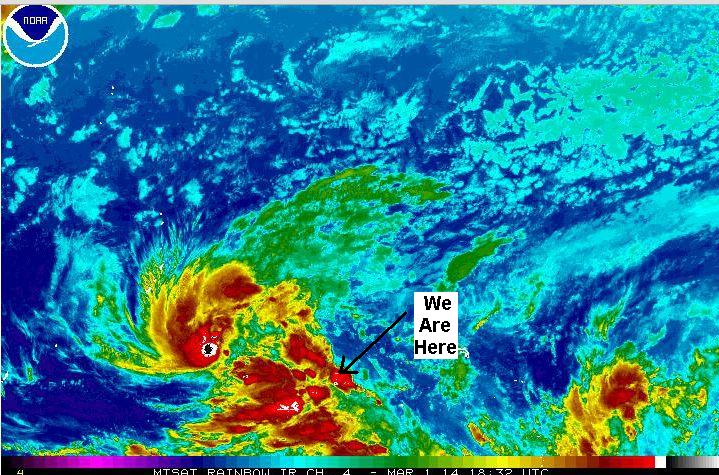
Subscribe to:
Comments (Atom)