Showing posts with label Pacific Passages 2012. Show all posts

Wednesday, November 28, 2012

Where's Windigo?

We were recently contacted by the owners of the vessel s/v Windigo.

Windigo, Abandoned at Sea
Last seen at 24-49.3S / 179-49.2E

I don't have full details, but Windigo was abandonded at sea a few weeks ago in a bad storm on the way from Tonga to New Zealand. The crew were injured in the knockdown, and were ultimately rescued by a passing freighter. But it seems that Windigo is still floating. Here is the email we have received:

Recently Steve & I (Tania) were on passage between Tonga and New Zealand and we were hit by a severe storm and rolled, we sustained a fair amount of damage to our home of the last 3yrs. She has no steering (possibly), no bilge, no battery (possibly..as we left the motor running) no lights, and a broken starboard hatch. SHE CAN SAIL all rigging and sails in excellent condition.

We are uninsured (unfortunately) and would love to see her again!!!

Windigo was last spotted on 17 November 2012

Position
24 degrees, 49.3min South
179 degrees, 49.2min East

SSR 141391 ON STERN

Windigo has a British flag and she has her dingy and motor still on board
Her Dodger is gone but the frame is half there.

Her HATCH needs to be closed, if anyone gets close enough to her.

Our bilge pump broke down during storm, so we are worried about more flooding.

If anyone spots her, please email us on sywindigo@hotmail.com

Steve & Tania are now in Auckland, heading to Opua Northland, to THANK the most amazing people Bruce & Marcelle on sailing yacht ADVENTURE BOUND who came to our side risking their own lives, we will be forever grateful. And of course Orion NZ Rescue Airforce,The NZ Navy and CAPT Norman Mc Nee, who all played a vital part in our continued future.

Thank you
Tania & Steve
s/v Windigo
sywindigo@hotmail.com

Windigo, Abandoned at Sea

Tania & Steve from s/v Windigo


You can read a little more on the incident on this BBC online account

In googling for some background on the incident, it seems that the "looking for our boat" has already been widely reported in the sailing news circles (Noonsite, Cruiser's Forum, etc).

Wednesday, September 12, 2012

Destination Fawn Harbor (We Think)

We are on Plan #39Z, having changed our plans a bazillion times over the last 2 weeks, as events have unfolded in Fulaga.

Our current, as of 7am this morning, plan, is to try to make it in to Fawn Harbor, on the south coast of Vanau Levu (near Savusavu) before dark tonight. Unfortunately, the high winds we left Fulanga in yesterday morning have petered out. We were screaming along at 7 knots with double-reefed main and hardly any genoa, yesterday. Now we are motorsailing to make it before dark. But the ride is a lot calmer than it was yesterday!!

We turned NW at Lakemba about 7pm last night, and have been threading our way through the scattered islands in the Koro Sea in the dark. It's a little scary doing this at night, because Fiji is notorious for bad charting. But we are using a 2010 version of the C-Map charts, a 2008 Garmin chart set, and Google Earth, to compare locations of the islands. And being very conservative. When everything agrees on the location, we feel reasonably confident we know its location. The largest deviation we have seen in our wanderings this year, has been 1/2 mile, so as long as we give a 1 1/2 mile margin (and confirm with the radar as we approach), we feel OK. Most of the chart deviations from our 2010 C-Map charts are only about 200 feet.

It's daylight now, so maybe we can pass a little closer to the islands and sight-see a little.

We haven't been fishing--we've still got quite a bit of fish in the freezer, and we're headed for the "Promised Land"... Savusavu, with lots of restaurants and good cheap food (and friends to share it with). And we are going to have to empty our freezer soon too. Fiji is the first place we feel we could have lived off the fish we caught, if we needed to. Big Mahi and Wahoo and Great Trevally's are plentiful and easy to catch.

We should have internet this afternoon as we approach Fawn Harbor. YEAH!!! (It's a good thing, too. Because Shadowmail has stopped passing my svsoggypaws email due to too many messages on the server).
-----
At 09/11/2012 7:32 PM (utc) our position was 17°20.43'S 179°27.75'W
http://svsoggypaws.com/currentposition.htm

Tuesday, September 11, 2012

Finally left Fulanga

We had a nice last day in the village at Fulanga yesterday. The other boat that came in the pass at the same time we were returning in Challenger, Margarita, kindly let us tow our dinghies behind their catamaran, and all 3 boats' crews went in for another sevusevu. The villagers put on another good 'tea' after sevusevu. We are amazed that they have actually been listening to our advice on how to handle, and take advantage of the expected cruiser influx, now that the Lau is more open to cruisers. They have formed a village committee to provide a 'welcome tea' to the cruisers, are working on a checklist of information, to make sure the cruisers are properly briefed on village do's and don'ts, and are rotating the 'host' duties among the villagers. Our friend Sikeli says by next cruising season, he will have the men in the village growing a few crops that the cruisers will buy (tomatoes, greens, etc). We left them with a working VHF and some idea of how to use it, and what it's good for.

We are happy to report that a couple of the guys off Margarita are savvy computer techs, and volunteered to take the school computer, which I couldn't fix, back to their boat and try to get it running. The school teacher detailed a couple of the older boys to lug the desktop computer and monitor down to the landing. Margarita reported this morning that they found a wasp nest in the power supply, and managed to clean that up, bang it a few times, and get it running again. Woo hoo! Another demonstration to the villagers of the value of establishing good relationships with the cruisers.

We haven't been able to get them off their $50 anchoring fee, but they do now have an inkling about how to make their village/atoll the 'must see' destination for other cruisers. We hope we haven't totally ruined them. But they were smiling, and waving, and crying when we left. Dave keeps promising them that we'll be back in January. Hopefully we can keep that promise.

We had planned to be 'anchors up' this morning at 7am, but our nice weather from yesterday turned unexpectedly to crap overnight. Rain, squally weather, and gusts to 35 knots most of the night. Woke up not expecting to depart, though we are anxious to get going.

Our "weather guy" David on Chameleon (aka Gulf Harbor Radio, based in NZ) advised us to sit for another day and let this go by. It is the top end of a trough connected to a low SE of us. But tomorrow's weather will bring wind going light and shifting to the NE, and then possibly N and NW... just the direction we want to head.

There were signs of the weather breaking a little during the net, and an hour after the net, we had partial sun, no rain, and steadier wind. The actual wind is still higher than the GFS forecast (and the Fiji forecast) predicts, but now more a steady 20 knots rather than 15-20 gusting to 30-35.

So we made the tough decision to get going. Curly, the deliver skipper on Challenger, who is headed west to Suva, opted to follow us out. He's on a schedule and we know that Yana is really anxious to get out of Fulanga and see Jerry.

We cleared the pass this morning at about 10am and are having a nice off-the-wind sail. Seas aren't too bad either. Sun is out, and we are headed for better weather (we hope). Our current plan is to overnight all the way to Qamea (just E of Taveuni) and spend Thursday night there. From there we are just a daysail downwind to Savusavu. We'd like to spend Friday night at Fawn Harbor, but we may skip that if the big southerly swell that is forecast, is running. Saturday we'll arrive in Savusavu. Then we have about 10 days to get Soggy Paws ready for our departure for the U.S.
-----
Sherry & Dave
Cruising Fiji for a few more weeks
http://svsoggypaws.blogspot.com

At 09/10/2012 10:55 PM (utc) our position was 19°00.39'S 178°35.92'W
http://svsoggypaws.com/currentposition.htm

Monday, September 10, 2012

Back in Fulaga

We had a great sail north. With a 20 knot wind on our quarter, we averaged 7 knots. We trolled 2 fishing lines and caught a nice Mahi Mahi and a big Barracuda.

Dave Lands a Nice Mahi

Yanina and the Barracuda

We successfully picked up Curly in Lakemba at sunset on Saturday night, had dinner, and turned right around and headed back for Fulaga.

Curly Being Rowed Out to Challenger

When we arrived in Lakeba, the seas were pretty high, and the surf was pounding on the reef. We watched a catamaran go into the Tubou anchorage, and get anchored. So we know it was possible, but Curly had told us that from shore observations over the previous few days, it didn't look like a very good anchorage. Very narrow pass, sometimes breaking in high seas, and if we had entered just to pick Curly up, we would have been going back out with the sun straight in eyes.

The NW anchorage at Lakeba was pretty nice (see Cyan waypoints in the Fiji Compendium). It has a very wide opening in the reef, and you can come straight in and drop anchor in 50 feet. The area is wide enough that (very careful) arrival in bad light is possible, and certainly departure at night is possible. And it is far enough inside the reef, that it was very calm, in spite of the wave action outside.

Sherry Showing Curly How to Use the Chartplotter

We arrived and dropped anchor about 5:30pm, had dinner, and left about 8pm. We sailed most of the night until we turned the corner at Namuka and headed more into the wind. Then we turned on the engine and motorsailed to Fulaga.

By 7am we were approaching Fulaga, when the engine coughed a couple of times and quit. Fortunately, we were still 2 miles off the reef, so we scrambled into sailing mode. Then I took the helm while Curly and Dave went below to figure out the problem. It appears to have been fuel supply issues. There is was confusion about which tank is full and how to change tanks. We had switched tanks the night before, but apparently, not correctly. Within 10 minutes, Dave and Curly had the aux fuel pump on and had the system bled. We got the engine back on and had no further problems with it.

During the night, we had been passed by a catamaran named Margarita, and they were circling near the pass, waiting for us to lead them in. So the two of us entered the pass around 9am, with no problems. It was a beautiful sunny morning and easy to see the bommies inside the reef.

We waved at Pandion, leaving for Vanua Balavua, as we were coming in.

We plan to go into the village today to say goodbyes, and leave tomorrow (Tues) morning to head north. We're still trying to figure out where we're going to stop on our way to Savusavu. We have about 4 days to get there. Latest plan is to stop for a short overnight at Lakemba, then overnight to Naivivi Bay at Gamea, then Fawn Harbor, then Savusavu on Saturday.

Saturday, September 8, 2012

Underway in Challenger

The wind, which was howling (20-25 knots) last night, has eased a bit and swung a little more east, just as forecast. (Thank you David and Patricia of Chameleon/Gulf Harbor Radio for your weather hand-holding).

Dave helped Yana do final preps on Challenger last night. Pandion helped out by using their SCUBA gear to get the fishing line off the prop, and check the hull for any major issues prior to going to sea.

Dave and I were picked up at 6:30am from Soggy Paws by Lola from Pandion, and ferried to Challenger. Yana was ready and we had the engine on and anchor coming up by 6:50. Out the pass with a reefed main about 7:15.

At first the wind was strong, but waves not too bad (in the lee of Fulaga). We were doing 7.5kts with less than full genoa. But the wind eased off to 15kts and we slowed down a little, so we turned on the engine to keep speed over 6 knots.

We turned up a little higher just west of Namuka, about an hour ago, and the relative wind change was good enough that we could turn the engine off. Right now making 6-7 knots, easy sailing. Big seas in the cuts between the islands, but over much of our route, the seas are down due to islands and reefs to windward.

Yana is on watch, I am on the computer, and Dave is where Dave always is on passage... sleeping. Sun is shining, and all is well.

ETA at Lakeba is between 4:30 and 5pm. Curly has a boat arranged to get him off to Challenger without us having to launch the dinghy, at the Wainiyaba anchorage (NW of town). This is an 'easy in/easy out' anchorage, so we'll drop anchor long enough to have dinner, and then leave and head back for Fulaga. The wind is supposed to be nearly east overnight, and then start going back toward the southeast, so we want to get southeast to Fulaga as soon as practical.

Saturday, June 23, 2012

Passage from Tonga to Savusavu Fiji

June 18-21 (still catching up)

The nasty weather finally cleared from Tonga, and we left our nice quiet anchorage at Hunga at 0945 on the 18th of June.

We had waited an day to let the wind, rain, and swells die down after the frontal passage, but as we got clear of Hunga, we could tell that the swell was still pretty large. But the wind had died down to 15-20 knots, so it wasn't bad. After a few hours the big waves were down noticeably.

It took 48 hours of fairly nice downwind sailing to make it to our first waypoint--Katafun1 just outside the Katafunga Passage through the Lau Group of Fiji. We had timed our departure to hopefully arrive and transit most of this part of the passage during daylight hours. Fiji is very reef-strewn and the charts are still largely inaccurate--in some places they can be off as far as 2 miles (we are told). Even though we had pretty good waypoints (from Curly's Neiafu to Fiji briefing charts), we still wanted to be able to see the reefs. It turned out to be a 'cakewalk'. The passage was several miles wide conditions fairly benign by that time.

Once we got inside the reef area, the waves died down completely and we enjoyed a really nice sail for the afternoon. But on the evening of the 3rd day, when we were fully within Fiji's reefy waters, the wind died completely.

We were already running the engine anyway. We were having some battery problems--I had noticed that our battery voltage was down in the 10 volt range while the fridge was running the night before. With the big swell and lighter winds, we were working the autopilot pretty hard. We ended up having to haul the Honda generator out and start it up to get the engine started!!

Without the battery issues, we could have sailed in at about 3.5-4 knots once we got through charging, but we were also racing an approaching front and needed to keep our speed up above 5 knots to get into Savusavu before the next bit of nasty weather arrived. So we just kept motoring through the night.

We arrived in Savusavu at 2:01pm Fiji Time (UTC+12). Our original ETA was 1:30pm, but we were reading about the check-in process on our approach, and discovered that the official lunch period in Fiji is 1pm to 2pm, and (small) overtime charges may apply. So we slowed our approach a little. (Later someone told us they'd never heard of anyone being charged for arrival during lunch--they just wait til lunch is over to do the formalities).

Our friends on Sea Flyer had arranged a mooring for us with the Copra Shed Marina--good thing too, because 2 or 3 other boats arrived before us, and we would have been without a mooring otherwise. As we picked up the mooring, of our friends called us on the VHF that we already had reservations for dinner at the Indian restaurant for 'Curry Night'.

We finally got finished with the volumes of Fijian paperwork around 4:30pm (3 officials representing 4 different agencies, about 10 pages of forms, and over $250 FJD to clear in). The officials were ferried out to our boat by the Copra Shed Marina launch, and all were very very nice. (We didn't actually have to pay the fees until the next day when we had money).

We are anchored in a small creek-like area (but not really a creek). Picture something like the anchorage area by Dragon Point in Indian Harbor Beach. Someone told us there were 79 boats here about 2 weeks ago, but things have cleared out a lot since then.

The Copra Shed Marina is a nice facility with a bar, a snack bar, restaurant, showers, laundry, small chandlery, travel agent, real estate agent, and a 'yacht club'. They have dock space for 6-8 boats and about 20 or so moorings. I was skeptical about the Yacht Club part until I saw a bunch of Opti's and Lasers stacked up next door, and sure enough this morning (Saturday) all the kids were out in the Optis. Feels almost like home.

We finally have decent internet for the first time since we left the U.S. in January, so as soon as I finish the urgent issues, we'll try to get some photos posted.

At 06/22/2012 4:23 AM (utc) our position was 16°46.67'S 179°20.05'W
http://svsoggypaws.com/currentposition.htm

Wednesday, June 20, 2012

Passage from Niue

June 10-17 (still catching up)

We weathered a very mild front our last day or so on the moorings at Niue. I was very nervous about it, because the winds were forecast to back all the way around through the west, leaving us totally exposed. However, it was forecast to be very light winds. So we prepped the boat for a quick departure, in case we got unexpected strong westerlies. Fortunately, the forecast was 'golden'. Light winds, a smattering of light rain, virtually no bad swell.

After turning in our car Saturday morning, doing a last load of laundry, and saying heartfelt goodbyes to our friends at Niue Backpackers/Niue Yacht Club, we set sail for 'points west' on Sunday. We were heading for Fiji and Dream Away for Vavau, Tonga. But the course to Fiji goes right past the N end of Vavau, so we were again traveling in company. Again we are amazed at how well matched Soggy Paws and Dream Away were in speed and sailing angles. Without really trying, we stayed within 20 miles of each other the whole trip--within VHF range.

We had a pretty short weather window between passing fronts, with fairly settled E-SE winds. But it was obvious we weren't going to get all the way to Fiji before the next front passed. So when we reached Vavau, we opted to duck into a small island and wait for the front to go by.


Dave Hauling in the Fish (using YoYo)


Nice Mahi Mahi!


Cleaned and Ready to Eat!

On our way around the north end of Vavau, we trailed our fishing line and caught a nice 4-foot Mahi Mahi. Fresh fish for dinner!!

Our friends on Dream Away headed in for Neiafu to check in to Tonga, and we hope to see them again in Fiji later.

This trip was 250NM, completed in 52 hours, anchor to anchor, for an average speed of 4.8 knots (the wind was pretty light and behind us most of the way). We ran the engine for 5.7 hours, mostly for making water and charging batteries, but also getting in and out of the harbors.

It took a couple of days longer than we expected for the front and it's westerly winds and rain to clear Vavau. But finally on Monday the 18th (Sunday, US time), we left Vavau finally for Fiji.

At 06/19/2012 6:42 PM (utc) our position was 17°26.61'S 178°06.67'W

Monday, June 18, 2012

Niue Arrival

June 1 - 2, 2012

We really really enjoyed our time in Niue. We arrived on a Friday afternoon of a 3-day weekend (Queen's Birthday is Monday and a holiday), so we were really fortunate to arrange clearance on Friday afternoon, just before things shut down. We had heard that since the weekly Air NZ plane comes in at 2pm on Friday, it is difficult to get cleared on Friday after about 10am. But a combination of emails ahead of time to Niue Yacht Club, telling them we were arriving mid-day Friday, and the presence of part of the World ARC fleet, also trying to clear in on Friday afternoon, helped us out.

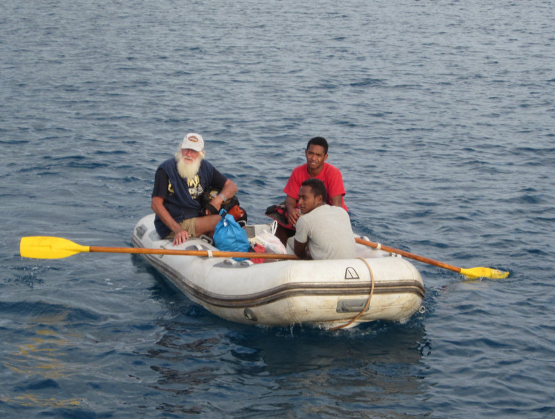
Our first adventure in Niue was the unique way they handle dinghies. Because Niue has no natural harbor, the only pier is a huge concrete pier in the open roadstead. Even on a good day, the ocean swell sloshes around the pier enough to make it hazardous to small boats, and in winds from NW to SW, the swell would pretty much smash any small boat left at the pier. So the Niueians use a crane to lift their boats out as soon as they arrive at the landing. The hook is left hanging about 4' from the water, so you have to unload your 'stuff', hook a bridle to the hook, hop out, and lift the dinghy with the crane. Sounded difficult, but it's not in calm weather. At high tide (when the waves are coming over the tiny reef surrounding the pier), or in swelly weather, it's quite a feat to just get out of the dinghy safely, not to mention get the dinghy up too. But we managed (after watching another boat do it just before us).

We did our paperwork with Customs on the pier (no charge) and then walked up to Immigration. Thanks to a phone call from Keith at Niue Yacht Club, who had met us on the pier, the nice lady at Immigration had stayed after hours to help us complete our clearance on Friday afternoon. Clearance in is free, but there is a $35NZ Departure Tax per passport.

Once we finished the paperwork, we found the Niue Yacht Club, which is currently located in the ground floor of Niue Backpackers facility. It's thirsty work doing all that paperwork!! So we had cold beers all around.

Ira and Brian, who own and run Backpackers, also handle a lot of the day-to-day stuff for Niue Yacht Club. Ira (pronounced ear-ah), started helping us almost as soon as we walked in the door. We'd been trying to arrange a car rental, but by the time we finished clearing in, both rental places were closed. No problem, Ira phoned the people at Niue Rentals at home, and insisted they deliver a car down to the Yacht Club for us ASAP. She said we could have the car for the weekend and do the paperwork with Niue Rentals on Tuesday morning. So by early Saturday morning, we had the keys to a nearly new 6-passenger van. We ended up keeping this car for a week, splitting the cost with Graham and Avril on Dream Away. The cost was $300NZ ($240 US) for the week (all inclusive).

The next challenge at Niue is getting cash. Since our trip to Niue was totally unplanned, we had Tongan, Fijian, and US dollars. Niue operates on New Zealand dollars. And this is one of the very first places in 5 years where there were no ATM's. And all the banks were closed. Most of the businesses do NOT accept any credit cards (and those that do, only Visa). Fortunately, Dream Away had a wad of NZ cash, and said they could stake us for the weekend, and we'd pay them back on Tuesday when the bank and businesses were open. (We ended up working a cash advance with Niue Rentals, using their Paypay 'pay for your rental by credit card' account, as the only bank in town has an extremely unfavorable exchange rate, and high cash advance fees).

We also got a shower key from Niue Yacht Club. You pay a deposit for the key, for which a small fee is deducted when you return the key. In return, they maintain two very nice family style showers on quay, with HOT WATER!! (our first hot water showers since November!!)

By Saturday morning, we were "sorted"--having gotten maps and info from the very nice Tourist Bureau, and a personal briefing from Ira on where to go and what to do--especially useful since it was a 3 day weekend, and everything's closed on Sunday. We had also made preliminary contact with Niue Divers, and talked about doing some dives with them during the next week.

So Saturday afternoon we spent doing the 'Sea Tracks' on the NW coast of Niue. A Sea Track is a trail and/or steps whereby you can access the water. Each one leads down to a beach, reef, or dramatic cave on the water. Ira told us "every one is different", and encouraged us to try to see all of them, if we had the time. (If you don't have the time, see the 'highlights' ones in the Tourist Brochure--they are the best).

We were amazed at how clean and orderly Niue is. Each of the Sea Tracks we visited were well-marked on the map, well marked with a nice sign by the road, had trash cans and sometimes a toilet and showers, and the grass was mowed and often the area was nicely landscaped. Compared to the 'take it or leave it' attitude of the Tongans (and the trash all over), Niue is a tourist's paradise.

Saturday, June 2, 2012

Arrived Niue

We are happy to report that after an easy 48 hour passage, Soggy Paws is on a mooring at the Niue Yacht Club.

The wind has already gone east of south, but the swell is still coming from the SSW, but lots better than yesterday. We are rolling some, but it should get better over the next few days.

A few of the World ARC Rally boats have also just arrived today, and they are having a BBQ tonight ashore for them, and we get to go.

We have already seen our first sea snake.

Passage Summary: 264 NM, almost exactly 48 hours anchor to anchor, for an average speed of 5.5 knots. We motored a few hours to get in and out of the anchorages, and for an hour or two once a day to top up the batteries.

More on Niue later.
-----
Sherry & Dave
On our way to Niue for a week, then Fiji
http://svsoggypaws.blogspot.com

At 06/02/2012 12:46 AM (utc) our position was 19°03.27'S 169°55.43'W
http://svsoggypaws.com/currentposition.htm

Friday, June 1, 2012

June 1, Twice

The weather is improving--the wind has backed to the SSW and eased a little. Last night was fairly 'lively', and we ended up really reefed down, surfing down big waves, with the wind on our quarter. With the wind behind us, it was 'freezing' in the cockpit, with a cold icy NZ wind blowing down our necks. But this morning the sun came out, and late this afternoon, the started dropping off a little and swinging more south. Tonight is supposed to be a beam reach in 15 knot winds, with 2/3 of a moon. Should be a nice night to be on watch.

Even though the wind has dropped, the wave action is still HUGE. There is a deep low somewhere down south of us kicking up some really amazing big swells. The Niue 'harbor' is exposed on the western side--just an open roadstead. Though the wind is forecast to be SE by the time we arrive mid-day tomorrow, the swells are still forecast to be coming from the SSW. This could be interesting--really really rolly for a day or so, until the storm south of us gets far enough east to swing the swells to the SE.

We are crossing back over the 'dateline' that we crossed on our way from Samoa to Tonga last year. (In actuality, at about 174 West Longitude, Tonga is physically EAST of the dateline, but their time zone is +13, making them over the dateline, for calendar purposes). Niue, on the other hand is -11. So as we transit between Tonga and Niue, we get to do do June 1 twice--today and tomorrow, but the time doesn't change!!

For those of you 2012 Puddlejumpers (and other cruisers) interested in Niue, make sure you download my Cooks and Samoas Compendium--there is a good section on Niue in there, too. (http://www.svsoggypaws.com/files/)
-----
Sherry & Dave
On our way to Niue for a week, then Fiji
http://svsoggypaws.blogspot.com

At 06/01/2012 5:40 AM (utc) our position was 19°36.99'S 171°33.12'W
http://svsoggypaws.com/currentposition.htm

Thursday, May 31, 2012

On Our Way to Niue

Well, the wind finally quit blowing, and we did get in a few more dives with Fins and Flukes. The last one was the best, out at a remote bommie (patch reef) called Lafa Lafa. It was very live with coral, LOTS of fish, a turtle, a few sharks, etc.

Meanwhile, our friends on Dreamaway, coming up from NZ, started emailing us about meeting them in Niue (pronounced New Way). Niue is 250 miles EAST of Tonga, kinda dead upwind. We had really wanted to go there least year, but just ran out of time. And the weather at the time we were contemplating it was 'blowin' a hoolie' and we decided to hang out longer at Suwarrow instead.

At first we thought "No Way!", and we talked Dreamaway into stopping off where we were in Tonga, since it wasn't far off their path from Minerva Reef to Niue. But we started looking at the logistics, and the weather, and decided it really was do-able for us, without having to t-t-t-tack.

There is a front and low passing south of us, which has turned the wind to a westerly direction. This is usually a problem in the Ha'apai Group of Tonga, because the chain runs North and South, and there aren't many places to hide in West winds. So we solved that problem by checking out for Niue.

We met Dreamaway at an anchorage just near the pass, late yesterday, had a reunion dinner and bottle of wine, and got ready to go this morning.

We left the pass just south of Uoleva (near Lifuka) today at 1pm, and expect these winds to carry us right to Niue in 2 days. In fact, right this second, we are struggling with having to run too far DOWN wind. (Our autopilot, Janet, does well 'DDW' (dead down wind), but doesn't like ~135 degrees apparent AT ALL, and that's where we want to steer for the direct course to Niue. She wanders like crazy and the sail's either luffing up or flogging because it is blanked by the main. But the wind is expected to slowly back from SW to S to SE in the next 36 hours. We have timed our arrival at Niue for when the winds have turned back East.

Niue is a unique place with no harbor, and almost no anchoring space (the Niue Yacht Club has put in moorings for passing yachts to use). There is no dinghy dock, but a lifting crane--you have to have a bridle on your dinghy, and hook it to the crane and lift it out of the water. Renowned for great diving, sea snakes, and very friendly people. Check out niueyachtclub.com.

If the wind turns west while we are there, we'll have to get out of there quickly, as there is no protection at all. So we'll watch the forecast carefully, and probably only stay about a week. Then we'll head for Savu Savu, Fiji, I think.
-----
Sherry & Dave
Still in Tonga for another few weeks, then Fiji
http://svsoggypaws.blogspot.com

At 05/31/2012 7:01 AM (utc) our position was 19°49.39'S 173°48.13'W
http://svsoggypaws.com/currentposition.htm

Saturday, May 19, 2012

Fonua One One Anchorage on the way to Ha'apai from Neiafu

Oops, looks like I didn't post one from there...

We had originally intended to stop overnight at Maninita, as that is the southernmost anchorage in the Neiafu group. It supposedly makes a good jumping off point for the Ha'apai. The guidebooks say it is a beautiful and protected 'one boat' anchorage. (We know of friends last year that had 2 boats in there, though).

However, when we arrived around 3pm, the conditions--windy, 85% overcast, and swell from the south, it looked very dicey to get in, and very confining. A narrow pass in the reef, and reef all around, all breaking. The swell was forecast to rise, and we didn't want to get trapped in a crappy anchorage. It is supposedly very beautiful, and I encourage people to visit it (it is also a bird sanctuary, so be kind to the bird life), when conditions are right--light winds, good sun, slight seas. It is close enough to places like Tapana to be a good day stop. I don't think it makes a very good overnight stop for an early departure for the Ha'apai.

The anchorage we'd recommend for your jumping off point to the Ha'apai is Fonua One One (I'm pretty sure that One One is pronounced "onay onay"). It is only a few miles north and west of Maninita. I don't think either of the 3 guidebooks we use cover it as an anchorage, and the chart is not very good for it. But on the north side of this island, off the west tip of the island, the reef extends far enough to the west that there is good protection from SSW through E. There is a dip in the middle of this spot that has a 15-foot sand shelf, with DEEP sand, and (just) enough swinging room in case the wind gets backwards. The big advantage over Maninita is that you can escape in any light, and any conditions as it is completely open to the north. As long as you don't mind anchoring off the drop-off, 2-3 boats could share this anchorage area easily.

When departing to the south around the east end, make sure you miss the reef that extends north and east from the island, and also the large, breaking detached reef a couple of miles to the south an east. You can go between Fonua One One and the detached reef. The reef breaks pretty spectacularly, so you can see it easily in most sea conditions.

On our 'wide area' Google Earth chart, Fonua One One doesn't even show up, though the islands to the north and east are there. I did go back in my 'historical' depictions and find one blurry shot (not properly downloaded to my cache, probably) that does include Fonua One One and the detached reef. If you are going there, I would suggest you try to get a good depiction of that area.

For reference, we dropped anchor at about 18-48.935S / 174-03.918W in the deep sand in 15 feet at the edge of the shelf SE of us.

There was a strong current running north through the gap in the reef just ahead of us, which seemed to persist no matter what the tide was doing. We believe it was caused by the southerly swell breaking on the reef.

At Ha'ano in the Ha'apai

We had a quiet night at Fonua One One, where we anchored the night before--a little rolly but decent protection. Certainly a LOT better than trying to get into Maninita under dicey conditions. We had one small Tongan fishing boat, with barely a cabin on it, anchored next to us for the night.

We got up at the crack of dawn and left the anchorage about 7:15am, with one reef in the main. The forecast indicated we'd have SE winds about 12-15 kts. Our course being about 195 degrees, this seemed like perfect sailing conditions.

We'd gotten a fish strike the day before, which had broken our 'sport' fishing line. So I made sure Dave had our strong hand-line rigged to put out as soon as we got going. I have been hungry for Mahi Mahi all summer, and you can't find them for sale at the market.

By about 7:30 we had all our sails up and were headed SSW for our northern tip waypoint at Ha'ano, about 53 miles away. We turned the engine off and, for the first time in 6 months, were actually sailing again. Ahhh!! We had sunny skies and perfect wind for our first passage in months. Even the autopilot, which we hadn't used in 6 months (and we hadn't got around to testing before departure) worked fine. We did have a little swell on our nose from a storm down off NZ, but it wasn't affecting us too much. While Dave napped in the cockpit, I watched the autopilot and read "Little Bee" on my Kindle.

Our perfect sailing conditions lasted only a couple of hours before the wind went to 10 knots on our beam--at those wind speeds, with any wave action, we just wallow along at 3 knots. And with an unknown anchorage, a long way to go, and sunset at 6:08pm, we couldn't afford to go 3 knots. I spent an hour playing with sails trying to get us going again. We pointed up a little, let out all the sail we had, and waited a little while, hoping for either a change in direction or a little more speed--a few more knots of wind and we would have been flying. Sadly, we ended up having to the engine back on to keep our speed up.

Around noon, we boated a very nice 3-foot Mahi Mahi--our first fish since somewhere in French Polynesia. Normally we wait til we are at anchor and clean the fish while standing on our swim platform on the stern. But as we would be getting in late, 6 hours hence, we had to figure out how to clean it while underway. Dave doesn't want to do it on the deck, where most people clean their fish, as we use our decks for our fresh water collection system. He did a nice job of cleaning it in our big sink, without getting too much fish blood over everything. Fresh Mahi for dinner last night!!

We ended up motorsailing the rest of the day. When the wind strengthened again late in the afternoon, it had gone back to SSE--too close for us to make our waypoint without a little assistance from the engine. By the time we were approaching the northern tip of Ha'ano, our conditions had changed considerably. The wind was now 20 knots and we had 100% overcast and rain threatening.

We arrived at our reefy 'open roadstead' anchorage just at sunsent, with 100% cloud cover, and barely enough light to see. Fortunately we had our Google Earth Charts, and 2 other boats' tracks, to help us in safely. The regular C-MAP charts are not very accurate here--they show us anchored on the land. But the GE charts are fantastically accurate (most of the time). Dave could see enough looking straight down that we were able to drop the anchor in a sand spot, and it held well. We are out of the wind and the wind-waves and safe for the night.

For information on making your own charts from Google Earth, google GE2KAP, a fabulous utility made by a fellow cruiser that will capture any Google Earth picture you have on your Google Earth screen, geo-reference it automatically, and save it as a KAP format file--which can be used in most computer-based charting programs. If you find it useful, make sure you drop the author a donation--he's put a lot of work into it and is offering it still as 'donationware'.

It was a good passage, and we are glad to be in the Ha'apai. Anyone following our blog who plans this leg from Neiafu should look carefully at Fonua One One (see previous post) as a jumping off point for the Ha'apai. This is a MUCH easier anchorage to get into and get out of than Maninita, and protected from ESE to SW, with an obvious shelf with good deep sand. It only costs you a couple of miles and a couple of degrees for the long leg, over starting from Maninita.

The anchorage we are in now, is well protected from the SE to N, but is open to the SW. The forecast is for a somewhat large swell rolling in from the SW, and we are starting to feel it now. The southern Ha'apai and Tongatapu do break the swell somewhat, but not completely. We're going to look at an anchorage today a few miles away at Foa (sun conditions permitting) that should give us protection from the swell too.
-----
Still in Tonga for another few weeks, then Fiji
At 05/18/2012 6:08 PM (utc) our position was 19°40.23'S 174°17.36'W
http://svsoggypaws.com/currentposition.htm