We pulled out of the Kavieng town anchorage on the afternoon of March 4th, after spending the morning provisioning and getting ready to move again. Late that afternoon we anchored at Albatross Channel, after motoring about 3 hours in a winding passage to position ourselves to go out the south entrance of the Kavieng area. There was another boat anchored in the spot we'd selected to anchor (looking at the satellite pic). It was dodgy getting all four of us anchored and comfortable in the area. But it was OK for an overnight.
The next morning we got underway around 0645, headed south and east toward Rabaul, with a planned stop at the Duke of York islands, just off Rabaul.
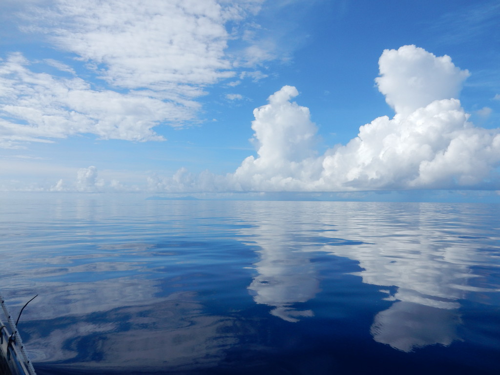
There wasn't a breath of wind...
The other boats motored straight for the Duke of Yorks, about 130 miles SE. But since it was so calm, Dave and I wanted to explore the north coast of Djaul Island, which was almost directly on the route. So we made a beeline for Bendeman Harbor (also known as Missionary Cove), on the north coast of Djaul. Our intent was to have a look in the harbor without going in. So I plotted our route to dog-leg down the coast just outside the harbor. As we approached, however, Dave wanted to take a few minutes to go in and check on anchoring depths.
Our charts are not that accurate in this area, so I went below to look at the satellite charts, and plot a route to download to the Garmin, so that we could safely go in the harbor. I left Dave on the helm and thought he understood not to go further in than where I had previously plotted the turn in the route.
I walked back out into the cockpit with the Garmin chip in my hand, and was horrified to find that Dave had proceeded on course straight past the waypoint. I didn't have time to react before BANG! BUMP! CRUNCH! GRIND! We had driven right into the reef guarding the entrance to the harbor! Dave didn't see the reef at all because it was glassy calm and a little overcast, so the reef wasn't visible at all.
Fortunately there was no wind, and no seas (and no one to witness our stupidity). We quickly dropped the mainsail, and Dave got in the water to assess the damage and see the best way to get ourselves off. We were relieved to find that (as designed), our saildrives were protected by the keels, and the keels had stopped us before the rudders hit anything substantial. The rudders were scraped but not damaged severely. After making sure we could run the engines in gear, Dave pushed from the bow and I motored in reverse, and we slid gently off the reef. Thank God!!
By then, a few villagers had gathered around in canoes, but we just smiled and waved, and motored into the harbor.

It was a long narrow harbor and would provide good protection in all but a howling north wind. And the reef we had run into provides some protection in NE.
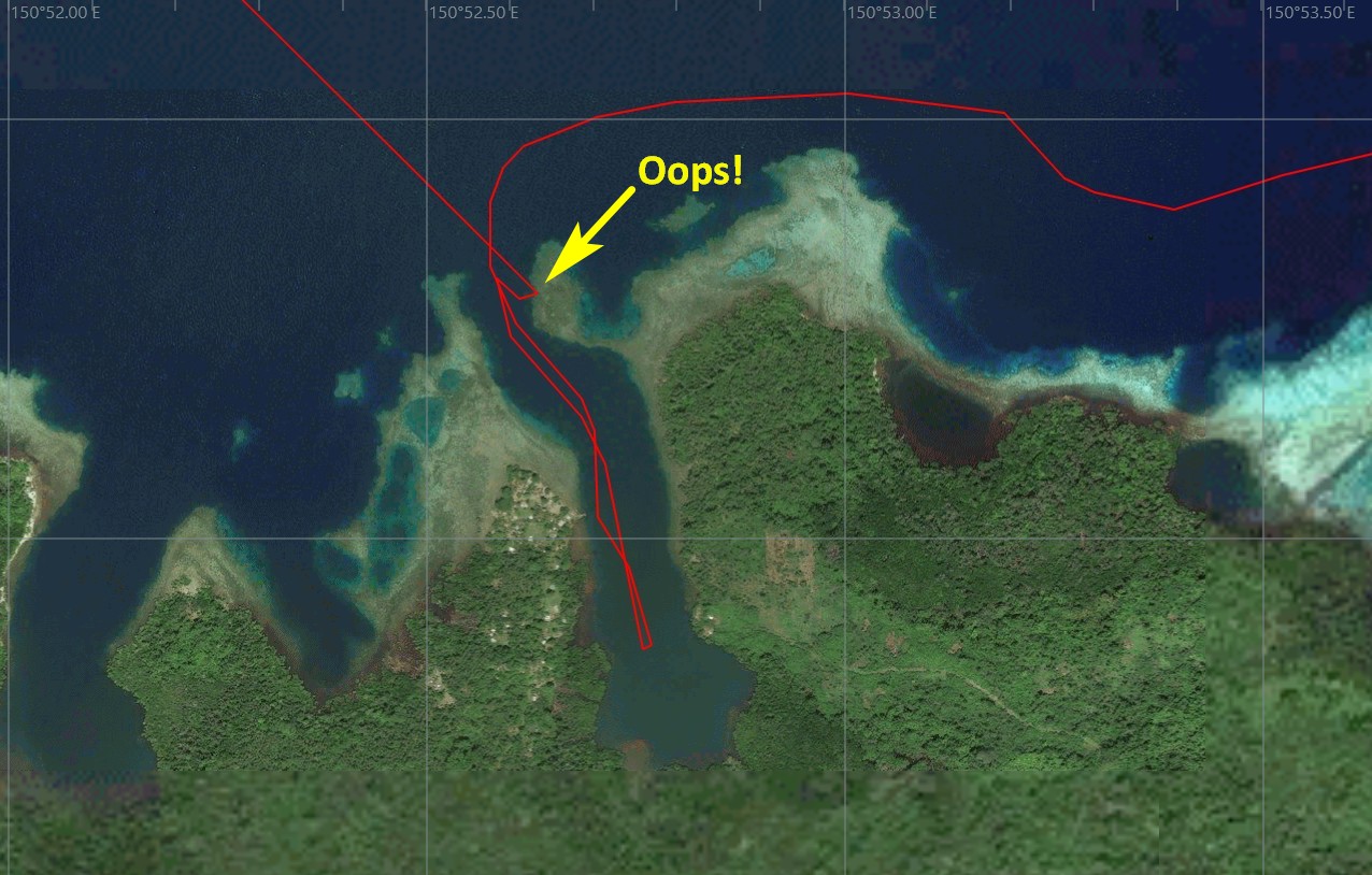
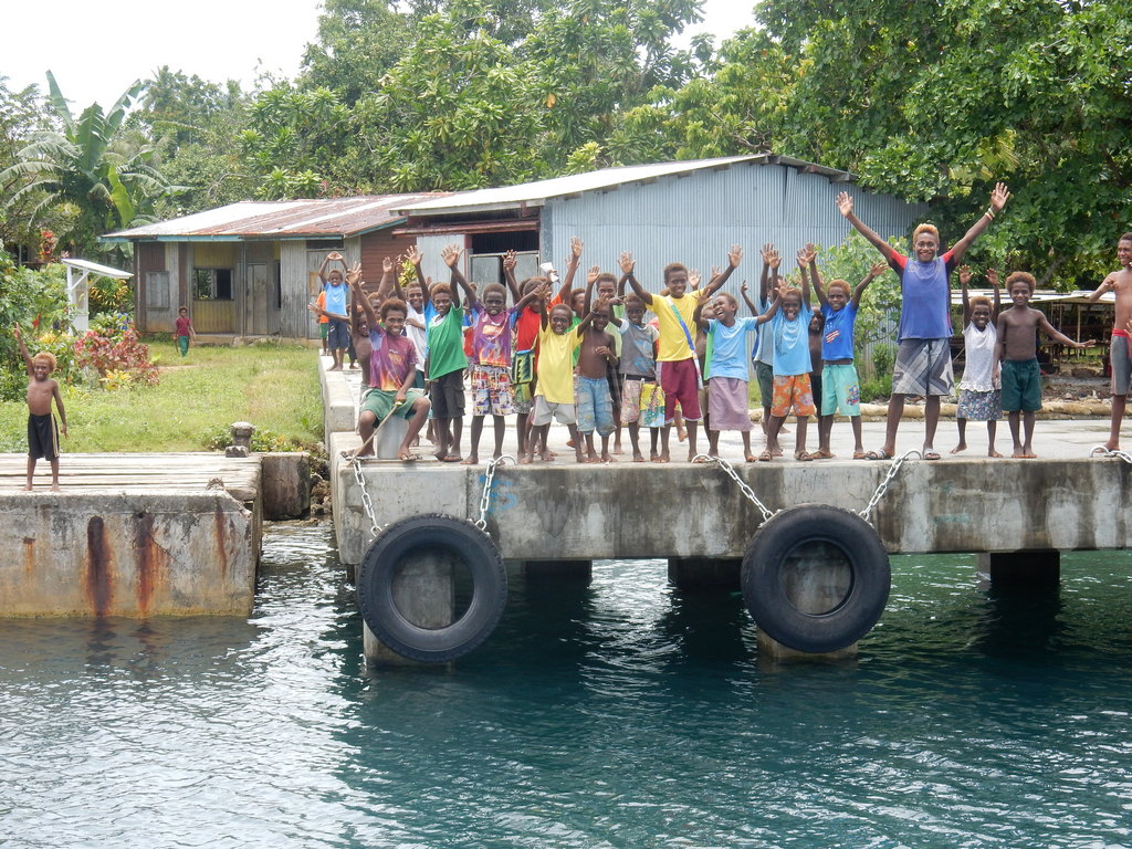
There is a substantial concrete pier on the west side, and all the kids in the village were standing on the pier waving at us. We felt bad about leaving without stopping to socialize, but we were on a mission...
The bottom was smooth at 85 ft deep off the pier, and it slowly shallowed to about 60 ft about 2/3 the way in. So it would be an anchorable spot. 02-54.63 S / 150-52.76 E.
Continuing on, carefully avoiding the protuding reef, we hugged the N coast of Djaul, looking for other possible anchorages. We found a couple that were possibles. The whole island looks pretty keen on the satellite picture. If we weren't on a mission to get all the way to Vanuatu by May, it would be fun to stop and explore this island for a week. Probably some great diving here too.
By early afternoon, we had cleared the island and set a direct course to the west side of the Duke of York islands. The wind came up enough to give us a small boost in speed, but not enough to sail without using an engine, unless we wanted to make it a 2 night passage. So we puttered along on one engine at 4-5 knots, and eventually made it in my 1530 the next day.
During the night, we saw a bright light about 15 degrees to starboard. It never changed course, it wasn't flashing, there was nothing on radar, and nothing on AIS. We never did figure out what it was. (Our buddy boats were too far ahed of us by then for it to be them). We speculated it might have been a light from Rabaul--maybe the volcano center (high on a hill)--as we were then about 80-90 miles from Rabaul.
It may have also been a "FAD" put out by a Filipino fishing fleet. As we saw something similar from afar several times later in PNG.
It was a fairly uneventful night other than that.
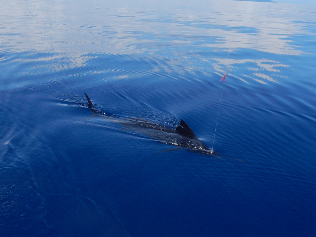
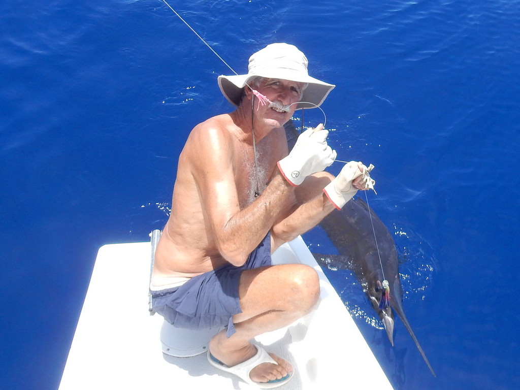
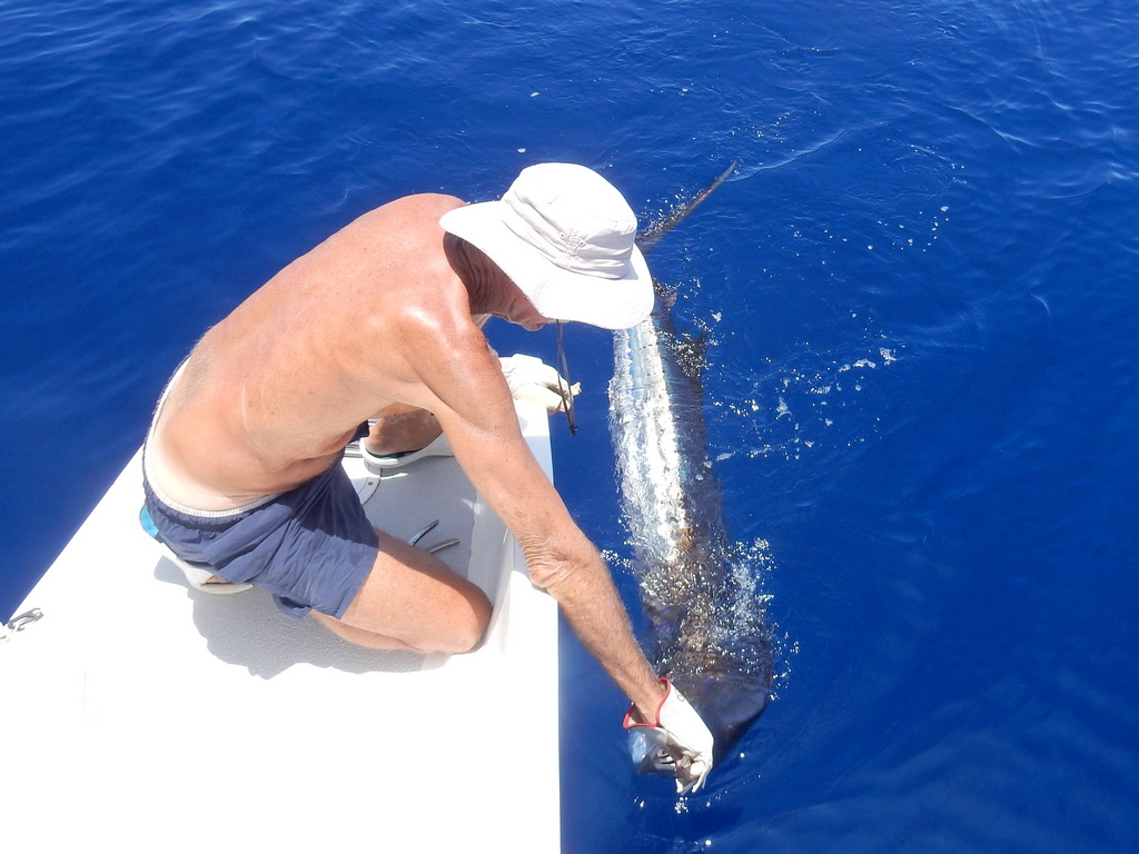
We take the fishing line(s) in at dusk, and put them out once Dave has had breakfast (can't catch a fish on an empty stomach!). On coming on to the bank where the Duke of York Islands are, we hooked a Black Marlin!! It was a good fight for an hour or so. We brought it in to take a picture (and get the hook out), and then released it.
We had barely dropped anchor in Mioko Harbor in the southern Duke of York Islands when a canoe approached us asking for an anchoring fee. A young man without much English paddled up to us and handed us an “invoice”, stamped and signed by a local woman. We refused to pay the fee without seeing paperwork proving the fee and the person collecting it was legitimate, and knowing what it was going toward. But our buddy boats all just went ahead and handed over money. One of our boats was actually first asked for a 500 Kina anchoring fee!! Apparently the local council has decided that passing yachts are a good source of income.
Later a guy in a canoe who said he was a teacher at the school, warned us not to pay (or donate) any fee that was supposedly going to the school, without seeing the ledger book that the school keeps. Apparently some unscrupulous people have solicited a donation for the school that never found its way to the school.
Just at sunset, the head of the council, who was aboard one of our buddy boats having a chat, suggested that two of us who had anchored further out in the bay, should move in closer to the village. He was concerned about boardings and theft during the night, and said his people would keep an eye on us.
The anchor spot where we first anchored was 04-13.68 S / 152-27.13 E, in 42 ft, scattered coral heads. We moved to 04-13.88 S / 152-27.12 E.
We left for Rabaul the next morning, but our buddy boats stayed another night. Apparently there is an opportunity to swim with dugongs (guided by a villager). They stayed to do so, but only saw one dugong from the surface. We just did not like the vibe there, and were anxious to get to Rabaul.
No comments:
Post a Comment