Showing posts with label Pacific Passages 2013. Show all posts

Monday, September 30, 2013

Marshall Islands Cruising Summary

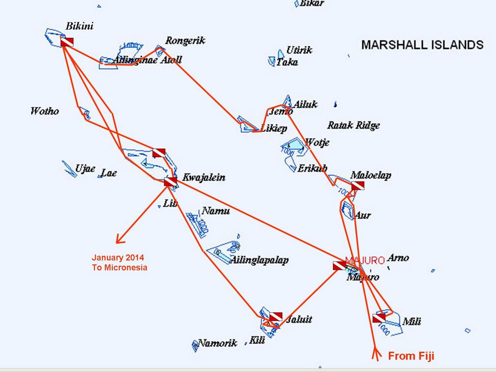
We were in the Marshall Islands from early May until early October. Here is a chart of where we went:

Our Crazy Summer in the Marshall Islands


We only spent 32 nights in Majuro Atoll (in 4 visits)--the rest of the time we were out cruising and diving. We used Majuro, and to a lesser extent Kwajalein, as a provisioning and social hub, and that worked our pretty well. You can get provisions, mail, cell phone and internet in both Majuro and Kwaj.

We had easterly winds from May-July and flat dead calm for all of August and September. The locals all said that it was unusual to have had as much wind as we did in June/July, and to have such a prolonged period of no wind in Aug-Sep.

If you've stumbled on our blog and haven't found our Marshall Islands Compendium, you can find it here: http://svsoggypaws.com/files/index.htm#Marshall%20Islands

Saturday, September 28, 2013

Another Easy Passage

We made the final leap of our summer's cruising from Jaluit back to Kwajalein Atoll, where we'll leave Soggy Paws for a few months to go see friends and family in the U.S. This trip was 251 nm, anchor to anchor. And we could have water-skied the entire way, the wind was so calm.

With 5 knots of wind the ENTIRE trip, the passage was exceedingly easy. Most of the time the wind was out of a northern quadrant, so it was essentially "on the nose". We were able to turn off the engine and sail for about 5 hours one night--oh blessed peace. But in flukey winds, on a schedule, it's a lot easier to just pull the sails in tight, crank the engine, and make some miles in the calm conditions. So that's what we did. We may set a record this month for the most engine hours since we left Florida. But, boy, have we seen a lot more of the Marshall Islands that almost everyone--cruisers and locals alike.

The only really memorable part of the trip was that Kwajalein was having "range activity" during the last night, and I happened to look up from my book at just the right time, and saw the missile (?) streaking in to Kwaj. It was kinda cool (but short-lived). The main activity at Kwaj is testing missile defense systems, and they shoot something into the area every couple of months. This is the first one we've seen ourselves.

Because we've been sending in Position Reports via Winlink, we get an advance email from some ham on Kwaj advising us of pending launch activity--the exact coordinates of the closure area, and the times the area is closed. The same notices are posted on shipping channels (Navtex, etc) so the shipping in the area knows about it. Most of the launches are scheduled for late night/early morning, so its not usually a factor in moving around during daylight hours.

We arrived at the South Pass at Kwajalein Atoll about 7am, and motor-sailed an additional 35 miles up to anchor at the north end for a couple of days. The weather is so great for diving, we thought we'd get a couple more dives on the airplane wrecks here, before we head in to put Soggy Paws to bed for awhile. We have a friend from Kwaj Base flying up on the afternoon plane to meet us here and dive with us.

We were amazed to find that the little store here has Romaine Lettuce and Tomatoes, and ice cream, and whole wheat bread. Plus we managed to buy a few gallons of diesel fuel.

On Monday we'll make our way south to Kwaj Base, where we've arranged sponsorship for us for the week we'll be onboard Soggy Paws. We fly out "Space Available" on a military flight on Oct 8, and are scheduled to arrive at Travis AFB (near San Franciso, CA) on Oct 10, after spending one night in Honolulu.

At 09/27/2013 6:39 AM (utc) our position was 09°23.60'N 167°28.29'E
http://svsoggypaws.com/currentposition.htm

Thursday, September 26, 2013

Passage from Majuro to Jaluit Atoll

Sep 18-19, 2013

Jaluit is only 120 miles SW of Majuro, but the fact that Majuro's only channel faces east, and Majuro town is at the far SE end of the atoll adds about 20-30 miles to the trip. But it was still only a single overnight to get there. As has been the case for the last 2 months, there was virtually no wind, so we motorsailed pretty much the whole way. When there was wind, it was 5-10 knots out of the NE, dead behind us, so not much good. We had a full moon, and without those pesky sails to mess with, it was a very easy passage in calm weather.

Though we had a lot of success fishing in Fiji, we have been almost completely skunked here in the Marshall Islands. It's not that there aren't fish here, because we know the sportfish boats in Majuro catch a lot of fish. I think Dave has just made one too many adjustments in his fishing tackle. We've also had a pretty full freezer, and so have not been as motivated as we could be to fish. I think I still have a Fiji "Walu" in the bottom of the freezer from February, and nice sashimi-grade tuna is pretty cheap in Majuro. Plus, of course, the light winds mean we've been motoring at around 5 knots most of the time--too slow for the fish we like to catch.

We arrived at the Southeast Pass at Jaluit (the pass nearest Jabor) around 2pm. Though we had a high overcast, we had good enough Google Earth charts and decent light, so it was an easy entry in calm weather. The current rips in an out of this pass. It was behind us coming in and we had about 2 knots of current at the peak. Since this pass faces NE, I would be a little leery of coming in this pass with a strong northeasterly and a falling tide. It would definitely be ugly. There is a SW pass that might be better in a strong NE wind. The midpoint of the SE pass is 05-55.62N / 169-38.40E

Charting: Like the rest of the Marshall Islands our Garmin (old) charts have no detail and are pretty useless. The CMAP CM93 charts from 2009/2010 are pretty detailed, but off a bit. I have been carefully using the Google Earth charts and OpenCPN and re-reference the CMAP charts (keeping a list which will go in the Marshalls Compendium). Once I get a detailed chart nudged a bit to line up with the Google Earth, then they are pretty damned good for navigating with. But I have found that sometimes when you get the GE/CMAP lined up in one place, it's out in another (on the same chart). So you have to be pretty careful. And of course, always use your "Mark I Eyeballs". But it's nice to know where we should be paying extra attention.

Most of the time, the Marshall Islands atolls are deep deep deep in the middle. But there are always scattered "bommies" that shoot up out of 150 feet to 2 feet, and then back down. The 2-footers are easy to spot. It's spotting the 5-7 footers that are sometimes the problem. But more of a problem is finding a shallow spot to anchor. The Google Earth charts are really invaluable here, as they can help you find those sand spots that look coral-free and not too deep and not to shallow.

Anyway, we came in the pass, made a left hook around to the Jabor anchorage, and dropped anchor off the big Jabor pier in about 45 feet mixed sand and coral. Our Anchor Spot: 05-55.15N / 169-38.48E If you go any further south than this, the water gets shallower, but there are tons of coral heads. You want to stay south of the pier, however, as there is a sunken tug directly off and slightly north of the pier, at 05-55.18N / 169.38.45E

It took us 2 tries ashore to find the mayor, to show our paperwork and pay our fee. But that was a pleasurable experience, as the major, Billa, a 50-ish woman, spoke excellent English and was very savvy. I think this is the very first time we actually met the mayor of an atoll--everywhere else we've been, the mayor has been in Majuro, and we dealt with an "acting mayor" who is usually not as good at English and not very "plugged in" to visiting yachties.

Friday, August 30, 2013

On our way back to Maloelap

Date: Today!

I am chagrined to report that I have still not had the time/taken the time to catch up on my blog. We are ever-moving ever-doing and it seems like there's no time to just sit in a quiet cabin and catch up (and there's SO much to catch up on besides the blog, when we've been out for the whole summer).

I still am hoping to get around to doing blog posts on

- Relatively uneventful sail/motorsail from Ailuk to Majuro with an unplanned stop at Maloelap (leaky exhaust)

- A short stop in Majuro for re-supply and internet

- A week in Mili Atoll, where we were able to dive in flat calm conditions on a B-25 bomber shot down in WW2 off the end of the Mili airfield. Because the conditions were so good, we located, photographed, and mapped parts of the airplane that had never been located before. We have shared our results with the Historical Preservation Office in Majuro (and with Matt Holly, the original discoverer of this airplane).

- Another very short stop in Majuro to provision for our trip to Maloelap

Plus of course, updating the existing blog posts with a few of the hundreds of photos we have taken!

We are now on our way 90 miles north to Maloelap Atoll, where we plan to do some more diving and land exploration of WW2 sites.

Tops on the agenda is to try to locate an as-yet-missing Corsair airplane reported shot down over Taroa Island in Maloelap. We have been trying to work with Matt Holly (who has been searching for this airplane for a number of years) and get a group of cruiser/divers together to do an organized search. Matt's been delayed and his disorganization has put off a couple of the boats that had expressed interest. But we and Challenger are going to get started anyway. We have enough information from Matt to know where he has determined the plan is NOT. Hopefully Westward II will be able to join us in a few days (they are working on engine issues in Majuro). And maybe Matt will actually join us in a few days also--sailing up with s/v Tribute.

The wind has been more or less "light and variable" for 3 weeks now, and the GRIBS look like it will stay that way for at least another week. Light winds are not unusual in the summer here, but a stretch this long with winds this light ARE unusual. It makes for terrible sailing but great diving.

So on we motor... ETA Taroa anchorage in Maloelap around noon.

Our future plans are to spend about 10 days in Maloelap, hit Majuro one more time for provisions, then stop in Jaluit (another Japanese base during WW2) on our way back to Kwajalein. We plan to leave Soggy Paws in Kwaj for October and November while we fly back to the U.S.

Tuesday, August 13, 2013

Passage from Likiep to Ailuk Atoll

July 29-30

We really liked Likiep and could have stayed for a lot longer. But the horizon beckons...

In the last few hops, we've been traveling southeast, and so our weather watch was always for northeast winds. In this passage, we'd be going northeast, so we needed to wait for southeast winds.

The winds in the Marshall Islands in the summertime are somewhat similar to those in the Caribbean in the summertime. There are "tropical waves" coming from the east every few days. Each wave brings a "wiggle" in the winds. As the wave approaches, the wind goes northeast. When it arrives, it brings wet weather, and a wind shift to the southeast. So the trick is to catch whatever part of the wave suits the wind you are looking for. And to watch out "vigorous" waves (or mentions of "Upper level support" in the text forecasts)

As much as people revile the GRIB, we really rely on them here. There is no real local weather forecast office. So the big computer in the sky is all we have to go on. That, and our eyes, of course.

So we knew from the GRIB files to expect the wet, and the wind switch to the southeast in the middle of the day. We were all ready--goodbyes ashore said, dinghy loaded, deck canvas down, passage meals cooked, cabin prepped. So when the sky started clearing and the wind shifted, we got underway immediately.

The point-to-point distance on this hop is only about 50 miles. If it was downwind, or a reach, we could have managed it as a daysail. But upwind, and tacking on 5-10 miles on each end to get from the pass into the atoll to the anchorage, we made it an overnight.

We picked up anchor about 1:30pm, and were out the SW pass by 2:30pm. Once out the pass, we had to go straight east for about 6 miles to clear the SE tip of Likiep. We did the first part motorsailing really close to the Likiep coast, trying to take advantage of the little protection it offered. Then when we started feeling the waves, we fell off a bit and sailed ESE.

Finally about 5pm we tacked over to head for the pass at Ailuk. We kept the motor on for another hour, until we were really clear of the reef that sticks out the east end of Likiep. At first we were making about 30 degrees true, but we got into the current, and most of the night we only made 15-20 degrees true. At dawn we were even with Ailuk Atoll, but 20 miles west of where we needed to be. So we tacked over and spent the next few hours sailing to the SE. The waves were really choppy behind the atoll--waves coming around both sides of the island meeting where we were!!

Finally we got close enough to the atoll where the waves weren't so bad, so we turned on the engine and motorsailed in. We went in the middle pass on the western side of the atoll, using Google Earth charts to navigate through the pass.

As soon as we were inside, we hooked up the watermaker (directly belted to the engine, like an alternator), and made water while motorsailing the 12 miles down to the village at Ailuk. We have to motor at reduced RPM, and the wind was up, so for some time we were only making about 2.5-3 knots. We finally got anchored behind our friends on Opus about 2pm. But with full water tanks of beautiful reverse-osmosis water.

Our anchor spot was 10-13.43N / 169-58.59E

Sunday, August 4, 2013

Passage from Rongerik to Likiep

July 24-25, 2013

We left the SE pass at Rongerik Atoll about 7:45am, in company with Challenger and Opus. Conditions were great. The wind had shifted as forecast more to the NE, and was down to about 10 knots--perfect for sailing to windward. As soon as we got out of the pass, we turned off the engine, and were having a great sail.

For several hours we were able to sail at a good speed, higher than the direct-line course to Likiep's NW pass. At that rate, we would have arrived in the early hours of the morning. But by noon, the wind had started to shift back more to the east, and get even lighter. My 4pm log entry says "Wind less than 10 knots... We are going slowly in the wrong direction... Cranked up the engine." But an hour later we were sailing again, the wind having come back again.

This pattern repeated itself all night long... too much wind, not enough wind, wind shifts left, wind shifts right. Drives ya crazy!! Our ground track from the log varied anywhere from 97 degrees to 165 degrees (with a desired course of 130T).

To compound things, once we got away from Rongerik, we were feeling the effects of the persistent westerly current--probably running a half a knot from the ESE. And occasionally, when the current runs into a big bottom profile, we get weird "washing machine" waves. You'll be sailing along enjoying nice conditions, and then all of a sudden, it gets rough and choppy, with waves coming at you from two different directions. Check the chart, and yup, there's the bottom contour. We REALLY slow down when we go head-on into waves. Just the effect of the waves will drop our average speed from 5kts to about 3.5 kts.

Finally about 3:30am, Dave got tired of trying to deal with the changing conditions, and "sailing slowly in the wrong direction", and pulled in the genoa, and turned on the engine. Even motorsailing, we were still not quite making the course we needed to make, but at least going closer to the proper course, and going at a more constant speed.

By daylight, we were almost in the lee of Likiep atoll. We continued on our course down to close in behind the reef, tacked over, put the fishing lines out, and motorsailed NE back up the reef. We kept our fishing lines out through the pass and all the way across the atoll to the anchorage we'd picked out from the chart. Got nary a nibble.

Challenger, who points a little higher than we do, and sails a little faster in light conditions, had entered the pass ahead of us, but had headed on to the SE to where the town of Likiep was. Opus came in about an hour behind us.

We went straight east from the pass, to the nearest island. I wanted a swim and a rest, and to get the boat sorted out, before we dropped anchor at the town and had to interact with anyone.

But when we got to the anchorage I had picked out from Google Earth (approx 09-59.6N / 169-06.8E), we found that the sand was full of coral heads. When the coral stopped, the depth dropped abruptly off to 60-70 feet deep. There just wasn't enough sand in shallow water to find a good anchor spot. We could have easily anchored in 60 feet, but we figured it would be easy to find a good anchorage further south somewhere.

Well, we ended up motorsailing all the way down to the town, 12 miles south. We did stop for lunch and a short swim on the tip of a sandbar coming out from an island, but it wouldn't have been a good overnight anchorage.

We kept looking for an anchorage that didn't have coral-studded sand, and had enough lee. But the angle of Likiep's eastern rim makes the islands line up with the wind, which was forecast to blow from the ESE for a couple of days. So there wasn't much protection. We did see one place that looked OK--at 09-55.47N / 169-12.05E. It wasn't great, though and the next island down looked better (it wasn't). We should have gone back there, but kept heading SE. The first decent-looking anchorage had some houses ashore, so we carried on to the main town.

We finally reached the Likiep anchorage, at the town, about 6pm, tired and cranky. Fortunately, it was a GREAT anchorage. A little closer to the town than we'd normally choose, but perfectly calm with no swell, and good holding in about 25 feet with a sand bottom (scattered coral heads). 09-49.54N / 169-18.29E

Passage recap: Point to point distance covered - 140nm at 129T. Tacking and navigating inside the lagoon, we covered 180nm over the bottom in 35 hours, 15 hours of it with the engine on.

Sunday, July 28, 2013

Bikini to Rongelap/Rongerik Atoll

July 17-19, 2013

We finally saw a decent weather window coming up for the ~90 mile (as the crow flies) trip to Rongelap. We were anxious to get going at the first opportunity. We were hoping to be able to catch an extended window, make it to Rongelap, get checked in and get permission to go to Rongerik, see a bit of Rongelap, and make it all the way to Rongerik (another 30 miles into the wind), in the same light wind period.

So, we were all ready to go by Wednesday afternoon. The wind was definitely calming down and shifting a little more north of east, but it still looked a bit iffy. Stephen had run out to the point--in the clear, he thought--in his dinghy earlier and said it looked good.

We weren't quite ready when Westward II was, so they went ahead on out. As soon as they did, Dave said "Let's just wait a bit and see what they report." Their first report was "it wasn't too bad", so we went ahead an hauled our anchor. But we hadn't even gotten out of the anchorage before we got another VHF call from Westward II, indicating they were coming back. The wind had moderated but the waves were still big enough that motorsailing into them would be a problem.

So we enjoyed our (hopefully) last sunset at Bikini, and prepared to get up early and get going the next morning. Sure enough, after the dark, the wind lay down even more, and shifted to about 070 degrees. At dawn I got up and collected another weather forecast, and it still looked good. So we finished breakfast and our final preps, and set off from Bikini about 0915.

The direct route from Bikini to Rongelap passes just north of Alinginae Atoll. If the wind was down and the seas flat calm, we would have motored straight to Rongelap, passing norht of Alinginae. But once we got going, the wind and waves were such that we opted to use Alinginae would provide a good wind/wave break. Instead of motoring almost straight upwind on the most direct course, we motorsailed SE to the SW corner of Alinginae, then hugging the Alinginae coast as much as we dared at night, motored upwind in the lee provided by the atoll. It was a great plan, and mostly worked, but we found that the "lee" petered out about halfway up the south coast. Then it was slow-going... motoring into light winds, seas, and a light current. We only made 3.5 knots for a few hours.

We had wanted to stop briefly at Alinginae just to see it, but we had been delayed so long at Bikini that we felt we were running out of time. And the timing to leave Bikini and stop at Alinginae was not good for going on to Rongelap, if we found Alinginae untenable. And we are supposed to have permission from Rongelap to stop there anyway.

We had nearly a full moon and great conditions while motoring along Alinginae. There was enough moon to see the breakers off to port when we got in close. With the CM93 (CMap) chart off by nearly a half a mile, we were relying on the Google Earth charts that we had made, to keep us out of trouble. (The Navionics iPad chart was off too, and the Garmin didn't have much detail).

Finally about midnight we cleared the SE corner of Alinginae, and were able to tack (still motorsailing) up into the gap between Rongelap and Alinginae, where we got some relief from the wave action from Rongelap Atoll. All this time, Westward II was 2-3 miles behind us.

We had all along toyed with the idea of just skipping Rongelap altogether, and continuing on to Rongerik, which it looked like we could reach without too much trouble by late afternoon. For this reason, we had had Challenger, who was in Rongelap ahead of us, pay our $50 fee to the "acting mayor" at Rongelap, and get permission for us to go straight to Rongerik. Westward II, on the other hand, is on a different schedule than we are, and they opted to go to Rongelap no matter what.

So, while we were underway, we got another forecast, and it just didn't look like there'd be another window soon that would let us keep going eastward. The timing and conditions being right, Soggy Paws tacked off (still motorsailing) to head around the SE tip of Rongelap. While Westward II slowed down and headed for the SE pass at Rongelap, planning to go in at first light.

Both of us had mixed feelings about our choices...and still do. It's terrible to come all this way, and then have to skip places you'd really like to see. And neither Westward II or ourselves wanted to split up, as we've found we're very compatible in temperament, cruising style, and cruising speed. But we're starting to feel the time pressure to get moving, to be able to see all the other "important" (ie World War II relic) atolls down the way, and still get back to Kwajalein in time to fly out in early October.

Long story short, the predicted shift from ENE to ESE winds, which would make our tack from the SE corner of Rongelap to the NW corner of Rongerik a pleasant sail, didn't happen. Instead of 12-13 ESE, we had 15-18 ENE... right in our face. So it was a wet and windy day. We actually t-t-t-acked 3-4 times! But we arrived in the anchorage at Rongerik before sunset, exhausted and salty.

We again used our Google Earth charts to chose where we would enter through the wide western pass area at Rongerik, and to watch for isolated coral heads on the way across the atoll to the anchorage on the east side. With the sun behind us, it was easy.

Of course, almost minutes after we got our anchor set, the wind eased back to 12-13 knots and shifted SE, only a few hours late.

For a crow-flies distance of 116 NM, we covered roughly 145 NM in 32 hours, unfortunately having to motor at (mostly) low RPM's the whole time. Had we tried to just sail it, we'd have spent probably another 24 hours tacking around.

So we made it ~100 more miles to windward. Only 2 more hops to go before we make it to the eastern Ratak chain of islands. Then all our sailing will theoretically be at good sail-able angles to the wind. (Time for the wind to finally drop to zero, as Dave promised months ago :P).

Thursday, July 11, 2013

Passage from Hell - Wotho to Bikini

The trip from Wotho to Bikini should have been an easy one. The forecast was for 12-13 knots ENE, and "scattered showers". The course was 85 miles NW, and should have have been an easy close reach in moderate conditions. We debated whether to make this a short overnight passage or a long day arrive-in-the-dark passage.

Dave hates overnights, so he was the one advocating the daytime passage. The rest of us (me, and Stephen and Selena from Westward II) prevailed, and we scheduled our departure for late in the afternoon.

We left our protected anchorage mid-morning, and went out and anchored near the island in the NW corner of the Wotho atoll, for a snorkle and a beachcomb. About 4pm, we hoisted the dinghies, picked up anchor, and exited the lagoon through the wide opening on the western side. We angled SW going out, so the sun setting in the WNW wasn't directly in our eyes. It was pretty easy to see the widely scattered coral "bommies" on the way out, and avoid them.

As we rounded the NW tip of the atoll, with all our sails set, the conditions were good, we were making our course, and congratulating ourselves on picking a good weather window. By early morning, our GPS said we'd be in Bikini.

But, about 9pm, on the "girls' watch", we started getting squalls. Selena and I got about one squall an hour for the rest of our watch (until 1am). Mostly the wind would go up to about 20-25 knots for a few minutes, switch a little more on our nose, it would rain a little, and then the wind would die down to 5-10 knots. At one point, the wind died out enough that I let all the sail out, and then turned the engine on, and of course 10 minutes later, the wind was back up to 20 knots and we were overpowered again. Frustrating conditions, but not terrible. I didn't get much book reading done, as I was too busy winching the genoa in and out in response to the wind changes.

"The boys" (Stephen and Dave) took over around 1am, and I was sure that Dave would have a much easier watch than I had. The forecast hadn't been predicting that much weather activity, and it should be just about over.

After a trying watch, I fell sound asleep below. About 3am Dave logged that we were sailing direclty toward our waypoint at Bikini, now 40 miles away, at 5 knots. That was the last log entry he made. Sometime between then an my next log entry 5:30 am, all hell broke loose. I logged at 0530 "Mother of all squalls--30+ knots, motorsailing with just a double-reefed main and staysail". The wind and commotion of getting the last of the genoa in in the increasing winds had woken me from a deep sleep around 5am. I never got a chance to go back to sleep.

At 0745, we checked in on our SSB on the Yokwe Net, reporting that we were 17 miles from Bikini, squally conditions and "wind still 20+ knots". But right after that check-in, things got much worse. For the next 3 hours, we had winds in the 30-40 knot range, and the seas quickly built to 10-15 feet. It was really scary. It's the worst weather either Dave or I had been at sea in in any cruising sailboat... after many years and many miles of cruising.

We considered heaving-to, but being relatively close to Bikini, where we knew we had a a sheltered anchorage with good holding, we carried on. We kept the engine on to maintain control, rolled in about half of our staysail, and eased the double-reefed main. We felt fortunate that the wind had shifted a little more to the east, so we weren't really hard on the wind, and we were still making our course to Bikini even in those conditions. We trimmed the sails to maintain about 5-6 knots. We tried to keep our forward progress as high as we could, to get in as soon as possible, but not too fast, as we'd start crashing through the big waves instead of sailing over them.

Amazingly, Westward II was right beside us through all this. We always try to stay reasonably close when cruising in company, for companionship and someone else to talk to, as much for anything else. But when the stuff hits the fan, it tends to be "everyone for himself". The crews make different decisions about sail plans and course changes, and the boats tend to spread out. But after an hour or so of the horrific weather, I looked out and there was Westward II a quarter mile away. It was comforting to have them right there--though they wouldn't have been much help in those conditions, if something had gone really wrong. They were happy to have us there, also, especially since we'd been in to Bikini before and knew the anchorage pretty well.

Just before noon, we went through the wide opening in the reef at the south end of Bikini Atoll, with Westward II right behind us. The wind was still in the 20-25 knot range, but inside the atoll, the seas were down to a manageable "heavy chop". We were only a mile downwind from the anchorage we'd left at Enyu Island a few weeks before. Whew! We made it!!

Just then, Westward II called us and said their engine had quit. Stephen has been fighting fuel filter issues ever since taking on a bad lot of fuel somewhere in Fiji or on the way to the Marshalls, several months before. He had just changed his filters again before we left Wotho. We offered to come back and give them a tow in, but they felt it was safer and easier in the conditions to just sail on in.

We dropped anchor in a nice sandy spot, and left a big area for them to sail onto anchor behind us. Fifteen minutes later, they came ghosting in under mainsail, and dropped their anchor.

Throughout the rest of the day, the wind eased and the sun came out. We had a big breakfast, and a nap, before we started cleaning up the boat and sorting things out belowdecks. Since we had expected an easy passage, stuff wasn't stowed as well as it should have been. But nothing was lost overboard, nothing broken down below. (Thanks mostly to Dave's always-meticulous preparations).

When I got a chance, I collected the weather forecast again, and nothing in the forecast, either the night before or the morning after, hinted at anything like the weather we had experienced. But the next day, the Discussion from Guam for the Micronesia atolls west of us, talked about a TUTT.

"MAIN WEATHER MAKER ACROSS EASTERN MICRONESIA IS A VIGOROUS UPPER-LOW AND TUTT NORTHWEST OF THE MARSHALL ISLANDS. DEEP CONVECTION CONTINUES TO DEVELOP EAST OF THE TUTT."

That's a weather term I have never heard before (or since). Our friends on Carina in Pohnpei emailed us this definition from the National Weather Service site: "A TUTT (Tropical Upper Tropospheric Trough) is a trough, or cold core low in the upper atmosphere, which produces convection. On occasion, one of these develops into a warm-core tropical cyclone."

When we were in the middle of it, I had been thinking it seemed like a tropical storm suddenly brewing up. But this never did develop any further, apparently. The atolls east and south and west of us never reported anything near as strong nor as sustained as what we experienced.

So, bottom line, when the Weather Guessers start talking about Upper Level Troughs, especially near the ITCZ, pay attention!
Sunday, July 7, 2013

Kwajalein to Wotho Atoll

June 28, 2013

We left the North Pass at Kwajalein (the closest one to Roi-Namur) at about 11am on Tuesday morning. The conditions, finally, were GREAT for diving, and not so great for sailing. Isn't it always that way??!! We briefly discussed staying another day to take advantage of the calm conditions, but all our dive gear was packed away, and we're on a mission to get back to Bikini by Saturday.

Challenger had sailed south back to Ebeye a few days before--with plans to hook back up with us in a week or two.

So it was just us and Westward II. While in Majuro in May, in the midst of a severe drought in the northern atolls, Westward II had volunteered to carry a bunch of water to distribute to islands in need, in 1-gallon jugs. They had packed their aft head with water. They also were given several large bags of clothing by a ladies group in Majuro. They had thought they'd been able to distribute these items within a week or two of loading them onboard, but their prop problems changed their plans, and they ended up in Kwajalein. Now 6 weeks later, they were anxious to get the stuff out of their aft head.

So we scheduled a stop in remote Wotho Atoll. Wotho is about 100 miles WNW from Kwaj--just a short overnight sail. Because of the light conditions, we left in the morning, hoping for a morning landfall at Wotho. Our first hour on passage, the wind was light enough that Dave and I hauled out the Code Zero sail from the forepeak and got it all ready to go. Our ETA at Wotho was about noon the next day, and we wanted to get in earlier than that.

Not a half an hour after we got the Genoa furled and the Code Zero set, the wind started picking up to a steady 10-15 (from 5-10 knots). We held on for a few minutes with the Code Zero, surfing down the face of the swell at about 8 knots. But it looked like the wind was there to stay, so we furled the Code Zero and put the Genoa back out. We enjoyed a nice evening of steady breeze and were making 5-6 knots. By the middle of the night, the wind had picked up another knot or two, and we were doing 7.5 knots, with an ETA at Wotho about 4am. We kept taking in more and more of the genoa, trying to slow down. But if we reduced sail too much, we'd roll a lot. And besides, it was beautiful sailing conditions--the seas were laying down and we had about 12-14 knots on the beam, and a full moon.

So we rounded the southern tip of Wotho about 5am. It was Dave's watch, and he rolled in the genoa and sailed slowly in the lee of the atoll, arriving at the "pass" about 7am. That was still too early to head in to an unmarked pass, with no real charts, looking straight into the sun. But we did it anyway.

We have a fairly good Google Earth picture of the area (converted to a chartlet by GE2KAP and pulled into our Maxsea/OpenCPN charting programs), and felt confident we could get into the village anchorage safely. It just so happened that Westward II got there ahead of us, so we had the novel experience of following someone ELSE in. It was easy--the pass was a wide opening. The bottom jumped from "bottomless" to about 60 feet in the space of one boat length, and then it gradually shallowed up to about 45 feet. With the sun low on the horizon to the east (roughly the direction we were going), the visibility wasn't great, but we went slowly and could see well enough in the clear water.

An hour later, we dropped anchor off the beach south of the small village, on the island in the NE corner of the atoll. An hour or so later, the "acting chief" was alongside in a small boat, along with a couple of his brothers. He checked our paperwork, to make sure we had the appropriate permission from the Marshall Islands Internal Affairs to stop in their atoll. There is no charge for stopping at Wotho, so no money changed hands. The acting chief, Hiram, invited us ashore to look around.

Monday, June 17, 2013

Back to Kwajalein

We finally left Bikini on June 5. The wind wasn't perfect for a sail back to Kwaj, but it was as good as it was going to get. The wind had shifted towards the north another 5 degrees and dropped a few knots (065 deg at about 17 knots). We waited an extra day to let the seas go down some, but it wasn't enough. And if we waited any longer, we'd find the wind strengthening again.

We left Enyu, the southern island at Bikini, about 2pm, in company with Challenger. We had hoped to be able to make the course for Roi Namur at the NE end of Kwajalein atoll. But when we got out there and saw the huge seas, we opted for the easier course--to go west around the NW tip of Kwaj, and down "the back side". This allowed us to sail on a close reach rather than hard on the wind, and was a much more comfortable course.

The first afternoon and evening was pretty nasty. We were close-hauled in fairly high winds (18-22kts across the deck) and big seas, so the leeward deck was aslosh with water pretty much all the time. We had a double-reefed mainsail, the staysail, and a tiny bit of genoa out--trying to find a speed that didn't pound into the seas too much.

Our closed chock on the leeward side, which is sealed into the deck with caulking, sprang a leak and was draining salt water into our dish cupboard. This has always been a leaky spot for us, and we have a bowl strategically placed in that cupboard to catch drips. But this cereal bowl wasn't cutting it in these conditions. I noticed water dribbling out of the cupboard underneath the sink and investigated. The area under the sink was aslosh too. So we put a big tupperware box under the leak in the cupboard, and checked it and under the sink every 30 minutes, bailing if necessary. And of course, picture this with the boat heeled 15-20 degrees and getting tossed around in the big waves. And of course, it was while I was trying to cook dinner also... Not fun.

But, on the other hand, we were happy it wasn't happening on the other tack, as that closed chock drains into a bunch of electronics (our nav station, etc).

By dawn the next morning, the wind had moderated some, and we eased out a bit more sail. We could make 6.5 knots comfortably, and were going to round the NW tip of Kwaj before sunset. Most of the afternoon we were only seeing 15-18 knots across the deck.

Once we rounded the corner, we needed to harden up (sail closer to the wind) to stay close in sailing down the in the lee of Kwajalein. We had a fairly pleasant dinner, sailing on the level, no seas, and making our course. But through the 2nd night, the wind dropped and shifted back east, until about 4am, Dave gave up sailing and started the engine.

We motored in through South Pass about 8am, and were at anchor off the island/town of Ebeye, next to our friends on Westward II by mid-day on Friday, June 7.
-----
Sherry & Dave
In the Marshall Islands for the summer.
http://svsoggypaws.blogspot.com

At 06/14/2013 10:18 PM (utc) our position was 09°20.17'N 167°30.35'E
http://svsoggypaws.com/currentposition.htm

Monday, May 27, 2013

On Our Way to Bikini Atoll

Well, I kept thinking I'd get time to blog at least one more post about Majuro, and then another one on our trip from Majuro to Kwajalein, and then another one on our short stay at Kwaj Army Base. But... if I wait til I have time to write all those posts to catch up to the present, I'll just get further behind. And we plan to re-visit both Kwajalein and Majuro in the next few months.

Suffice it to say that we enjoyed both Majuro and the Kwaj Base--for short term stays. The base reminds me of a cross between Key West and Kennedy Space Center. Key West because of the island atmosphere and the fact that the primary transportation on island is bicycles--primarily "Keys Cruiser" type bikes--fat tires, big seats, and big handles. KSC because there is a minimal government presence and most of the people work for one contractor or another. More on Kwaj later.

We are currently on passage from Kwajalein Atoll to Bikini Atoll. We are having a very fast ride--a beam reach in 15 knots of wind. We are heavily reefed--2 reefs in the mainsail and only half of the genoa out--and we are still doing about 7 knots. We could go faster, but we just don't need the speed that much and are much more comfortable at 6.5-7 knots than we would be at 8 knots. The total distance from Kwaj Base to Bikini Island is about 225 nm. We left at the crack of dawn yesterday and expect to be in by late afternoon today. This may well be our fastest passage ever.

Though we have the windward side of our excellent cockpit enclosure down, and the cockpit is mostly dry, it's very salty out there from the salt spray getting sucked in on the leeward side of the cockpit. And of course, the occasional huge wave that slaps us and forces water in the cockpit around the enclosure.

So I am down below at the Nav station, eating crackers and cheese (breakfast). Dave is asleep in the salon on the couch--he's strapped in with a "Lee Cloth"--a piece of cloth we use to keep us on the narrow couch when we heel and/or the waves are big.

Our friends on s/v Challenger arrived in Bikini 2 days ago, direct from Majuro, but we haven't had a chance to talk with them by radio yet, other than to confirm they arrived safely (Jerry is terrible with radio skeds).

On this trip from Kwaj, we are sailing in company with s/v Panacea. Rick and Sue from Panacea are cruisers we met last year at the SSCA Gam in Melbourne, and they are currently working on Kwajalein. They sponsored us to allow us to get into the restricted area at Kwajalein. This is a big responsibility, as they are totally responsible for our behavior in the regulated environment of the Kwaj Base. If we violate the rules, the sponsor can lose his job and get kicked off the island. Rick and 2 buddies are taking Panacea for a week's trip to Bikini, while Sue saves her vacation time for their next trip off island.

Our friends on s/v Westward II, who we hadn't planned to see until mid-June, came into Kwajalein unexpectedly a few days ago because one of the blades on their 3-bladed fixed prop sheared off while motoring at sea. Rick from Panacea shook the bushes at the Kwajalein Yacht Club, and managed to find them a 2-bladed propeller to use for the short term, while they wait for a new prop to be shipped in. Even though this prop is too small, and spins the wrong way for their engine, it at least lets them move about a little bit. They just have to use their transmission in reverse. (it is a Hurth, so they can just run in Reverse to go forward).

Steve and Selina from Westward II are Aussies, and don't have an official US Visa for the Marshall Islands, so we can't get them on the Kwaj Base. But they are anchored off Ebeye Island, a few miles from the Base, and within VHF and ferry contact. There is also internet (NTA wifi) and cell phone coverage there, plus a decent grocery store. They are staying put this week while we run off to Bikini with Panacea (we have another trip planned to Bikini in June with Westward II).

Bikini Atoll is THE destination that Dave had in mind when he bought Soggy Paws. At least 15 years of his life has been focused on getting us here. Every time we've been diving anywhere, Dave has said to me "Just wait til we get to Bikini, it will be better there." So we are both very excited about finally reaching Bikini. More later...
-----
At 05/26/2013 10:57 PM (utc) our position was 11°01.09'N 165°50.76'E
http://svsoggypaws.com/currentposition.htm

Tuesday, May 14, 2013

Passage Tarawa to Majuro

Passage recap: 384 nm in 66 hours (2 3/4 days), for an average speed of 5.8 knots. The trip was close on the wind the whole way, but not terrible. We kept up more sail than we usually would, because we were trying to get in in time to check in on Friday.

We didn't notice much current ourselves, but others have remarked on the current.

Our route was to stay east as much as possible, without having to actually go east of the islands on the way to Majuro. The course is generally 345 degrees, but we varied our course from 325 to 360 based on the wind and land situation, using waypoints on the NW tips of Butaritari and Mili as intermediate points. We were worried about the last bit between Mili and Majuro, but the wind swung a little more east (vs ENE), and the last leg we were worrying about was no trouble at all.

We got into the Majuro mooring field about 12:30pm on Friday, and we finished with Customs and Immigration by about 3pm.
-----
At 05/10/2013 1:21 AM (utc) our position was 07°06.22'N 171°22.34'E

Saturday, May 4, 2013

Made it to Tarawa

We arrived in Tarawa about 2pm this afternoon. Unfortunately they have declined to clear us until Monday. So we are quarantined aboard until then. Not really a bad thing, we'll have a leisurely day tomorrow, sleeping in, having a big breakfast, and cleaning things up.

Officially, we should be anchored off the main town of Betio, awaiting our clearance. But that place is a commercial port, full of big fishing boats and a few big freighters. It is also completely exposed across about a 10 mile fetch across the atoll, to the NE winds that are blowing right now. So it would be a miserable, and perhaps dangerous anchorage for us. So we have opted to anchor for the next 36 hours in the 'Parliament' anchorage (approx 01-21N / 173-02E). This isn't perfectly protected from the NE winds, but much better than out at Betio.

We will have to retrace our steps about 7 miles back to Betio on Monday morning, to get properly cleared. This means that Dave's original plan of 'clear on Saturday, tour on Monday, and leave on Tuesday', ain't happening. So much for schedules...

Our friends on Challenger won't even arrive until tomorrow (Sunday) afternoon. Since we can't get out of here by Tuesday afternoon, we'll probably stay til Friday, so we don't arrive in Majuro on a weekend (and incur $150 USD weekend clearance charges).

We are looking forward to a day of touring the WWII battle sights here in Tarawa.
-----
Sherry & Dave
On our way to the Marshall Islands
http://svsoggypaws.blogspot.com

At 05/04/2013 8:51 AM (utc) our position was 01°21.36'N 173°02.01'E
http://svsoggypaws.com/currentposition.htm

Friday, May 3, 2013

Sailing Across the Equator One More Time

The last 2 days have been pretty uneventful. The wind has been light--barely sailable. We've spent half our time motoring and half our time sailing slowly. But with the exception of one or two afternoon showers, the weather has been exceedingly nice. Just not very much wind.

One highlight has been occasional visits by a large pod of small dolphins. These guys are about 2/3 the size of the dolphins that hang out in the Indian River in Florida. They are zippy and playful, and fun to watch. But hard to get pictures of.

After another 12 hours of motoring, we finally reached some steady sailable wind this morning. And now the wind has picked up to 12-14 knots (as forecast), and we have had a really nice sail this afternoon.

We've been dragging our fishing lines for the last 2 days, because the seas have been calm enough that it would be feasible to boat a good-sized fish and clean it. But we haven't had a nibble. Yesterday we weren't going fast enough, but with the wind picking up--maybe tomorrow morning before we arrive in Tarawa.

We crossed the Equator this evening at 6:56pm local time. We held off dinner and watched the sunset and the GPS, and then had a little ceremony as we crossed. First we toasted Neptune and thanked him for keeping us safe--we shared a shot of Fiji's finest "Bounty Rum" with Neptune. Since this is our 4th crossing in Soggy Paws, we are both already "Shellbacks" and there was no need of the first-timers shenanigans.

Then we ceremoniously spread some ashes on this sunny portion of the Pacific equator... first my Dad's ashes, and then our friend Henry "Mike" Mikelait. I also had a short sniff over other departed family members that I am missing (Mom, brothers Larry and Jimmy, and cousin Fred), all travelers and sailors and whom would have loved sailing across the equator with us.

As the seas are still fairly calm and the wind reasonable, we had a great dinner--pork chops, real mashed potatoes, and green beans.

We are now less than 100 miles to Tarawa, with an expected arrival tomorrow about mid-day. We are threading our way between two atolls tonight, to have a nice off-wind sail into Tarawa tomorrow morning.

Our friends on Challenger are about 100 miles behind us now. Jerry has opted not to run his engine much, and so they are still in the wind-less area, drifting along at 2 knots, hoping the wind we have found will someday reach them too.

We are already looking ahead to the next leg, from Tarawa to Majuro. There's always a problem with logistics--not just the weather, but timing departures and arrivals around weekends, and trying to avoid overtime charges. Ideally we would be ready to leave Tarawa probably on Wednesday, but that would put us into Majuro on a weekend. So we may have to either hurry up and leave on Tuesday (and then make sure we keep our speed up so we can get into Majuro and get checked in by Friday afternoon), or hang out in Tarawa til Friday, and arrive on Monday. But I see some fairly hefty winds coming in the forecast if we wait that long... *sigh*
-----
Sherry & Dave
On our way to the Marshall Islands
http://svsoggypaws.blogspot.com

At 05/03/2013 8:35 AM (utc) our position was 00°09.86'N 173°47.86'E
http://svsoggypaws.com/currentposition.htm

Wednesday, May 1, 2013

Still Struggling with Light Winds

I guess we should have just kept going (past Funafuti) when we had the good winds.

But we didn't. And now we are stuck in a big wind hole. When we left, the GRIBS said we'd only have about a day of light winds and then we'd reach stronger winds, but the wind hole has expanded and now we are on the second day. We have been able to sail some, but yesterday evening was filled with squalls (lots of wind, then no wind), and about noon today the wind went basically to zero.

So we are slowly motoring NW, hoping that the promised winds will fill in. It looks good the day after tomorrow... :(

At least it isn't blowing 25 knots!

At least the engine is running, and we have a good supply of diesel (purchased in Fiji at $5.80 USD per gallon *cough*)

Meanwhile, we've been getting a lot of reading done--studying up on Tarawa and on the Marshall Islands.

One thing that's nice about almost no wind is that it's easy to cook, so we've been eating well.

Our ETA in Tarawa is Saturday morning--we have about 315 miles to go now.

Hopefully we can get cleared in on Saturday. We are hoping to schedule a tour of Tarawa for Monday, and then leave for the last leg--333 miles from Tarawa to Majuro--on Tuesday.
-----
Sherry & Dave

At 05/01/2013 7:53 AM (utc) our position was 03°12.97'S 175°38.62'E
http://svsoggypaws.com/currentposition.htm

Monday, April 29, 2013

Drifting Along at 3 Knots

After a great first 24 hours, the wind has begun to peter out (as forecast). I've been using all my skills learned while racing Fast Lane to keep this big ol' boat moving in less than 10 knots of wind.

Once the wind got to less than 10 knots, we rolled in the genoa and rolled out our Code Zero. It is a great sail in this wind--it is very light and 20% bigger than our big genoa. However, a minor cloud passing by at dusk reminded us that we probably shouldn't have it out at night, as it is too hard to see the wind coming until it is too late. So we've got the genoa out for the night.

Right now we are doing 3.5 knots in 5 knots of wind--not too bad for a 40,000 lb boat. But we're getting close to the point where we might have to crank up Mr. Perkins (the engine). We were hoping to be able to sail through the night and hold off cranking up the engine until the morning, but we'll need just a little cooperation from the wind.

For the next 200 miles or so, there is a 1-2 knot west setting current, so we can't afford to drift along forever at 3 knots.
-----
At 04/29/2013 7:59 AM (utc) our position was 05°47.09'S 177°55.64'E

Sunday, April 28, 2013

Underway for Tarawa

We got underway this morning for the 700 mile trip to Tarawa, in the Gilberts Group of Kiribati.

Wind is almost on the beam at about 13-15 knots, so we've been having a rousing sail at 6.5-7 knots.

ETA Tarawa approx 6-7 days.

-----
At 04/28/2013 3:05 AM (utc) our position was 08°02.23'S 178°59.91'E

Friday, April 26, 2013

In Funafuti for a Few Days

The wind picked up nicely and stayed steady, so we made it in the Funafuti Atoll by about 12:30pm, and had our anchor down by 1:30, in a nice sandy spot, 35 feet deep, off the "Government Building", next to s/v Proximity.

We found the SE pass to be easy to transit in our conditions--wind about 085T at 14 knots, and an outgoing tide. We were a little worried about coming in against an outgoing tide (the wind against the current problem). We had expected some turbulence with an outgoing tide and a mostly opposing wind, but saw little evidence of it. I guess the pass is wide enough that it doesn't cause a problem. We arrived at the pass at noon with great sun, so entry was easy. It turns out to be wide open and pretty well charted and marked.

Once we had our anchor set, we hustled around to get the dinghy launched and the sail covers on, so we could go to shore and get cleared in. Customs and Immigration close down promptly at 4pm, and we managed to complete 3/4 of our clearance before 4pm. The last step was to drop the "Health Quarantine" form off at the hospital. We decided to do that tomorrow. We also managed to talk the Immigration officer into clearing us OUT for Sunday. Customs wouldn't do that and told us to come back tomorrow.

Since they were nearly 45 miles behind us, Jerry and Ulyana on Challenger couldn't quite make it in before dark. Since the conditions were good, a full moon out, and we had traversed the same route during the day, Jerry decided to come in after dark. The atoll is well charted, mostly 100 feet deep, and the marks and lights are mostly where they are supposed to be (unlike Fiji). They arrived safely and anchored behind us about 9pm.

Friday morning, I went in with Jerry and Ulyana to help them get cleared in, go drop our Quarantine form off at the Hospital, and try to clear out with Customs. A different Customs officer was there, and I showed her the Immigration clearance, and she cleared us right out. Jerry, on the other hand, was told "no" by the (different) Immigration officer. But HE took the Customs clearance back later in the day and got Immigration to clear him out.

They only get about 20 yachts a year stopping through here, and the last boats we know of were here in December. So it's understandable that they're kind of rusty on the procedures. Clearing out on Friday for a weekend departure was our idea, and may not be strictly according to regulations. But only one person mentioned the word "overtime" and suggested they clear us on Sunday. But we managed to smile a lot and ask nicely and got our clearance completed on Friday.

Cost to clear in and out in Tuvalu: Nothing.

We'd really like to stay longer here, but we're on a mission to get to Majuro by May 10th or so, and there's a light patch of wind coming in 2 days. So we plan to hustle on northward tomorrow, to get past the area of light winds before they get here.

Trip Summary - Savusavu to Funafuti: 6 calendar days, 2 overnight stops, 608 NM, 117 Hrs Underway Time, 50 Hrs Engine Time.
(High proportion of engine hours caused by having to motor east against the wind around the east end of Fiji for 2 days in light wind, then one day of squalls and light weather on the way to Funafuti). We made it by Dave's Birthday!!

-------
At 04/25/2013 2:09 AM (utc) our position was 08°31.56'S 179°11.35'E
http://svsoggypaws.com/currentposition.htm

Wednesday, April 24, 2013

Blessed Wind

After motoring all night, dodging minor squalls, dawn brought sunshine and a light but sailable wind.

We put out our our Code Zero sail--a 3-ounce roller-furling big headsail, on the new bowsprit that Dave fashioned for it, and sailed all day in about 5-7 knots of true wind at about 4-5 knots. (It is quite a feat to get our heavy boat moving in that light a wind). Once or twice the wind died off, and we started the engine. But as soon as the wind came back, we shut it down again. We were trying to maintain an average of 4.5 knots, to get us in before dark tomorrow.

The wind has finally filled in (as predicted several days ago). We rolled in the Code Zero at dusk as the wind came up to 8-10 knots--too much for that light sail. We are sailing now on a close reach at 5-6 knots in 8-10 knots of wind. If this holds all night, we should be able to make the SE Pass at Funafuti Atoll by mid-afternoon.

Another boat we've been talking to on our "Trans-Equatorial Net" (12359 at 2000Z), Proximity, were supposed to make it in to Funafuti today (see their blog link on the left hand side of our blog). They've come down from the Marshall Islands and are headed for Fiji. We've already scheduled a pot-luck for the 3 boats we know will be there, on Friday night.

Challenger, whom we thought would beat us in to Funafuti, is about 45 miles behind us. When the stuff hit the fan yesterday, I guess their tacking decisions weren't as good as ours. Somehow we managed to wiggle through all the bad weather without getting hit hard again. But Jerry reported to us on the radio that their bad weather continued through the night last night and they made terrible progress. But, on the other hand, they've also been fishing--they reported that they caught a good sized Mahi Mahi this afternoon.

We haven't even put our fishing line in the water, but we will tomorrow. It's a pain to catch a big fish while at sea (no good place to clean it without getting everything all nasty). Dave spent the day of fairly calm weather repairing things, while I spent most of my time tweaking sails, trying to keep our speed up.

We are down to 95 miles to go, and looking forward to landfall tomorrow.
-----
At 04/24/2013 8:08 AM (utc) our position was 10°02.99'S 179°26.86'E

Tuesday, April 23, 2013

NW Winds Weren't in the Forecast

.. and neither was 25-30 knots! (Note to non-sailing friends--this will be boring!)

The GRIB files--almost the only thing we can use at sea in this area for a forecast--showed that our wind would peter out and shift to the NE about noon today, and stay "calm" for almost 36 hours. So we have gotten some extra easting, in anticipation of NE winds. And we were mentally prepared for light winds and the possibility for motoring for awhile if it really went dead calm as indicated.

What we WEREN'T prepared for was the "Mother of all Squalls". We had already been through a number of squalls and felt somewhat Monty Python-ish about them ("I laugh at your squalls"). Silly us. Today about noon, after successfully dodging a couple of squally bits, but making good progress still under sail, we got hit with a really big black one.

As it approached, we conservatively rolled in the genoa, and only had a little bit of sail up when the wind started to rise. Normally the wind goes up to 25 knots for about a minute, and then starts to ease off, and in 5 minutes you're sitting there rolling in the swell, your sails slapping, and no wind at all. "Well, wasn't that fun??!!" But today, it hit 25, and then 30, and stayed there for about a half an hour. That's a fairly frightening bit of wind. It was all we could do to keep the boat under control, and under those conditions, you are always wondering what might break. (Thank god nothing did!)

We still had a double-reefed main and about half a staysail out, but we turned on the engine to better be able to control what happened to us. We were in survival mode for quite awhile. The seas built really quickly and soon we were burying the bow in huge waves. Dave, who hates it when a little bit of salt spray gets on his deck, was really cringing with every wave. (Me too, as I know that some of that salty water will find its way below in all kinds of hard-to-reach places).

We struggled with that storm for almost an hour, and then when the winds started to ease off, we tried to fall off and head back NNW toward Funafuti, and found the winds directly on our nose. We assumed that the wind would go back to normal like is usually does after a squall passes. But it never did. Crap! Wind on the nose!!??

We tried both tacks. We tried motor sailing. We tried just sailing. And the waves were like a washing machine--no matter which direction we went, we were still pounding straight into the waves. All we did for most of the afternoon was sail back and forth in bad conditions. We only made 8 miles toward our destination in 4 hours. And there were more big black storms in every direction. It was truly an afternoon from hell.

Fortunately, about 4pm, the wind finally started dying off. It's still on our nose, and it's still a washing machine out here, but we're finally able to motor directly toward Funafuti at about 4 knots. That's big progress, but we spent so much time screwing around this afternoon, that we may not get in to Funafuti for Dave's birthday. :(
-----
At 2013/04/23 8:02 AM (utc) our position was 12°00.69'S 179°47.05'E