Showing posts with label Tuamotus. Show all posts

Sunday, February 18, 2018

Rice Wine for "Out There" Cruisers

This is for our friends cruising in the Bahamas, central South Pacific, Indonesia, and any other cruising grounds in remote places without reasonably priced stocks of wine.

Another cruising boat we met last year, Gaia, from Holland, gave us this recipe, which they passed on from another cruising boat. I include below the original recipe, and then what we did that worked for us.

I had previously looked into "making wine" a bunch of times over the past 10 years of cruising. But the instructions always seemed so complicated. For example...there was a huge debate on the forums about which esoteric wine yeast to use. It always put me off. And who had wine yeast aboard when you got desperate for some wine? And, didn't it take 2-3 years before the wine was drinkable?

This recipe is diffent--so simple--and 2-3 weeks to yield drinkable wine. For a bottom-shelf wine drinker, with no other recourse to wine, it's a pretty good solution--extremely affordable, and the ingredients are probably already on your boat.

Why would we make our own wine? When we were in Tonga, a TERRIBLE bottle of white wine was $25 USD! (if you could find one). In Indonesia, at least in the outer islands, you can't find wine, at all. In the Bahamas, liquor is not bad, price wise, but beer and wine is outrageously priced. So here goes.. original "sailor's wine" recipe, and exactly how we brewed on Soggy Paws last year in Indonesia.

Sailors rice wine recipe (original recipe)


Rice wine recipe makes 10 litres
1 kg white rice, washed and skim off the bugs
2.6 kg sugar
12 litres water
2 teaspoons yeast

Add options:
2 handfuls of raisins
2 lemons thinly sliced

Other add options:
Cranberries instead of raisins
Cherries instead of raisins
Oranges instead of lemons
Pomelo (sweet grapefruit)

You have to find out the quantities and flavours you like best.

Stir daily.
Cover with cloth or wrapping plastic with an elastic. So air can go out if necessary, but not in. Fermentation takes +/- 2 weeks.
Siphon into sterilized bottles. Let sediment settle for several days till the liquid is clear. Siphon into serving bottles.

To sterilize the bottles:
Just 1 or 2 drops of Betadine(Iodine)in a cup of water. Just let it in the bottles and container till you start using them. Use more water and Betadine for your container.
--------------

Here is what we did on Soggy Paws last year in Indonesia.

--------------------------------------------
For a gallon jug (US Measures)
--------------------------------------------
1 cup rice
4 1/3 cup sugar
water to fill gallon jug
2-3 tsp plain old bread yeast (I use a 10-11g package, which is a little more)
1-2 slices lemon or lime (or a tsp or 2 of some bottled lime or lemon juice)
A small handful of cranberries or raisins mixed

Don't cook the rice, just rinse it enough to get the bugs out (if necessary), and throw all the ingredients together in your brewing container.

I brew in a 1 gallon apple juice container, with the cap on very loose, and sitting in the sink in the head. WARNING: Big problems if you tighten the cap too much--it definitely needs to be able to off-gas! I did have a one gallon jug that we tightened up the cap, and it got a little too excited and sort of exploded and made a mess in the head. The jug and fermentation is much more volatile early on, and then tapers off. So if you are sitting for a week, good time to start a new jug.

I brewed in my jug for 2 weeks exactly (I tape a piece of blue tape with the due date). A little longer (3 weeks) tends reduce the sweetness. I tighten the cap, shake the jug well, and then loosend the cap again, at least once or twice a day.
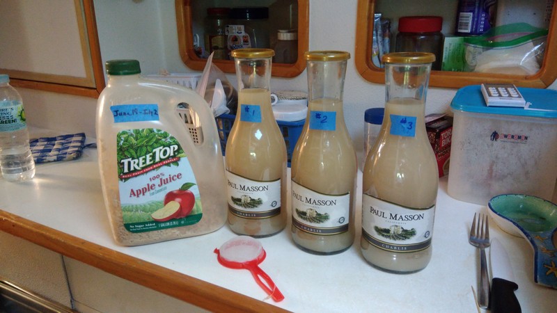
My Rice Wine Brewing Kit


When it came to "siphoning off" to bottles, I did that one time with a proper siphon hose and decided that was too much trouble. I ended up just pouring my 2-week-old fermented rice wine from the gallon jug into the "clarifying" bottles, gently, using a funnel, and leaving the sludge in the bottom of the jug. I did filter what I poured off through a fine-mesh plastic filter (a plastic filter, a little cotton cloth, or a paper coffee filter might work also). What I used is the red "filter" in the foreground in the picture. I labeled my clarifying bottles 1, 2, 3 because the first one was easier to keep the sludge out than the last one. The #1 clarifying bottle generally had a little less "sediment" in it, and took less time to clear up. (In the end, for a thirsty person, it didn't matter).

Once the very fine sediment falls to the bottom of the clarifying bottle, the wine looks clear, and looks very much like white wine. Then siphon or pour gently off to your serving bottles. It takes at least 3-4 days for the stuff to settle to the bottom of the clarifying bottles, and the milky wine to turn clear. But if desperate, you don't have to wait that long! Chill well, and it's a decent substitute for that evening glass of white wine.

I have found that I have quite a bit of left over rice in the gallon jug. I tried re-using the rice (just adding a little more), but the brew ended up too sweet for some reason, so now I throw out the used rice and start new.

It was totally drinkable, and certainly better than paying $25/bottle for terrible wine. I sometimes use it to stretch my existing (cheap boxed) wine by mixing half and half.

Once I ran out of the wine I brought with me, I started making a 1 gallon jug every week or two. By the time I decanted it the gallon jug into "clarifying bottles", this turned into three 1 liter Paul Masson clarifying bottles. Once decanted to 750 ml "serving bottles" (leaving sludge in the bottom), it would make about 4 standard 750 ml wine bottles. With 2 1-gallon Jugs, and 3-4 Paul Masson bottles, I always had enough to share with my (also desperate) friends.

I never bothered testing the alcohol level--it was a good enough facsimile to wine that I wasn't worried about perfection.

I did use the Betadine method to sterilize the jugs and bottles.

Try it, and see how it works for you!

Wednesday, January 31, 2018

Updated Tuamotus Current "Guestimator"

Many thanks to both s/v Brindacier and m/v Starlet who both updated the tide tables in my old "guestimator" and sent in a copy. Both are included in the zip file, which can be found here: http://svsoggypaws.com/files/TuamotusCurrentGuestimator.zip

Cruiser's helping cruisers--I love it!

Sunday, June 12, 2011

Au Revoir, Anse Amyot

One of the biggest downsides of traveling as we do is eventually having to say goodbye to special friends we have met along the way. It was with genuine tears in our eyes that we hugged Valentine and Gaston one last time this morning, and started preparations for a two-day trip to Tahiti.

The last week has been frustrating for the 15-18 boats bottled up at Anse Amyot--waiting first for some wind, and then waiting for the wind to stop blowing. We went from literally zero wind to 25-30 knots within a few hours last Saturday as a cold front swept in, and it has been blowing like stink since then, until late yesterday.

Before the wind started blowing, we took advantage of the calm conditions to do a lot of diving. We made at least one dive a day, and on the really calm days, two dives. We explored along the wall further in both directions--finding a few more neat dive spots. We usually had an entourage of several dinghies following us--some new friends. One a diver, and another couple were avid snorkelers. It was nice sharing our favorite dive spots with everyone, and it's always safer having at least one extra dinghy along when going outside the atoll (it's a long drift to Tahiti!!).

Once the wind started blowing, we mostly stayed on the boat and caught up on chores. I finally got the courage to upgrade the hard drive in my laptop. I had bought the drive back in February, but never had the time while we were in Hawaii to get it installed. Our friend Gene on Reflections, on a mooring with us at Toau, gave me the encouragement I needed, and also loaned me his drive enclosure and a disk cloning program. That made the job really easy.

Dave did Preventive Maintenance on the dive compressor, and also lots of other similar chores around the boat. Together we spent one whole afternoon removing and re-bedding the port genoa track--which leaked like a sieve on our way down from Hawaii.

In addition to the boat chores, we enjoyed socializing around the small fleet. We had several happy hours ashore, as well as other social gatherings for important functions like burning trash and swapping books.

Today when the weather finally calmed down, Anse Amyot emptied out. 14 boats scattered to the wind--3 went south to Fakarava, 1 went north to Apataki, and the rest headed west for Tahiti. We were the last of a group of 4 boats who left around 3pm today. Everyone is joking about having to keep a proper watch on this trip, because so many boats are headed for Tahiti right now.

Anyway, all is well. We are looking forward to getting to Tahiti and checking out the big grocery store we have heard about. We are almost out of bread, and are down to our last tomato.
-----
At 6/12/2011 7:50 AM (utc) our position was 16°05.37'S 146°43.16'W
http://svsoggypaws.com/currentposition.htm

Heading for Papeete this Afternoon

No time to write right now, but just want to report that we are heading out this afternoon for a 2-night passage to Papeete. ETA Papeete early Monday morning. More later!!
-----
In French Polynesia til August, then west toward Tonga
At 6/12/2011 12:41 AM (utc) our position was 15°48.19'S 146°09.17'W
http://svsoggypaws.com/currentposition.htm

Thumbs up for New Solar & Frigoboat

Now that we've had some time to watch and observe, we are really ecstatic about the upgrades we made in our solar charging system, and our refrigeration system in Hawaii.

On a sunny day, our solar array now handles all the electrical requirements and has the batteries topped off by early afternoon. This is in the South Pacific winter, where our days are only about 11 1/2 hours long, and the sun never gets properly overhead. At 7:30 am, we are generating over 10 amps into the batteries, and at mid-day, we are generating a peak of 30+ amps. Even on a fully-overcast day, we are charging 8-10 amps mid-day.

The Frigoboat systems have been performing well too. Our freezer stuff is rock-solid, and the fridge is adequately cold to keep everything nice. We still have a small bit of lettuce, green peppers, celery, cabbage, and carrots, as well as some apples left in the fridge after 6 weeks. Plus all the butter, cheese, eggs, and milk products. Fridge run time varies quite a bit depending on how often we get in the fridge. Both units combined are using approximately 80 amps in 24 hours.

The 'Smart Speed Control' on the Frigo systems has not been as useful as we'd thought. One problem is that the Danfoss compressors (or their controllers) make quite a bit of SSB noise, so we turn them off at the circuit breaker frequently when we are on the SSB. This resets the 'memory' on the SSC--so it seems they are always running full bore rather than at slow speed. We can manually force it to a slower speed, but that somewhat defeats the purpose of the SSC. And we have to manually reset it every time we turn the power off. I think if we had to do it over again, we wouldn't bother with the SSC and would use instead the Danfoss speed control module, or a very inexpensive (about $30) manual switch. We have both of these as spares and might switch out at some point.

But all-in-all we are very happy with both systems.
-----
Sherry & Dave
In French Polynesia til August, then west toward Tonga
At 6/7/2011 11:10 PM (utc) our position was 15°48.18'S 146°09.17'W
http://svsoggypaws.com/currentposition.htm

Friday, June 3, 2011

At Work and Play in Toau

We have been here a few days now and are really enjoying the 'idle time'. But we haven't been completely idle.

We have been diving every morning outside the atoll on the drop-off. So far we have only visited the sites we had found last year. But the wind has finally dropped off to nothing, so today we will go further afield and find some new spots. I also have been snorkeling the reef beside the anchorage every afternoon. The water is only 8-10' deep, with coral heads that come up to within a foot of the surface. When the tide is coming in, it is crystal clear. All the pretty fishies are playing around the coral heads--hundreds around each big head. I like to just drift around watching them feed and play. After I snorkel, I go back to the boat and leaf through our copy of Reef Fish of the Pacific Ocean, trying to become familiar with the names of all the fish.

In one of these lazy snorkels, I discovered tiny pipe fish--only about 4-5" long and as big around as a piece of yarn. They look like little short snakes, but with a funny goose-like beak. They hang out in clusters in the mossy areas around the top of coral heads. Now that I know where to look, and what to look for, I see them on almost every head with moss growing on it. I like to just hang motionless and watch them 'grazing' on the moss and swimming around.

The 'work' part of my day has been disassembling and cleaning our big genoa winches. On our last passages, under heavy strain, our starboard winch started squeaking a little. As the 'sailing master' aboard Soggy Paws, it's my job to keep the sailing equipment shipshape. This is a nasty dirty job--we clean the old dirt and grease off the winches with a pail of kerosene. These winches (Lewmar 48's) have about 10 gears inside, and every gear has to be soaked in kerosene and patiently scrubbed with a toothbrush and a metal pick to get all the old caked grease and dirt from between the teeth in the gears. Then it has to be reassembled and every square millimeter of surface area coated with a thin coating of new grease.

I thought I had the manual for our winches downloaded from the internet, but found it doesn't properly cover our older Lewmar 48's. There was one part we couldn't figure out how to take apart. But fortunately one of our CSY friends back in Florida, with directions in hand, actually took their winch apart so they could try to figure out what I was talking about (thanks Warren!!). It is very difficult discussing technical assembly instructions without being able to share diagrams, which we can't do on our Sailmail. But after several back-and-forths via email, we finally got it figured out. As I took everything apart, I took pictures of each gear assembly before I dismounted it from the main drum, and then took it apart. These were invaluable in getting the darned thing back together correctly. But I finally finished both winches--they are back together with no pieces left over, and they are operating smoothly!!

Dave, meanwhile, has been splitting his time between keeping up with boat-related maintenance, being 'mooring field manager', and social director for the boats here at Anse Amyot. With the help of Bruce and Clark from s/v Two Amigos, they finished restoring the last mooring to 100%--just as 2 more boats came in and took the last two available moorings. We now have 11 boats on moorings here. There is currently only a catamaran mooring available (in shallower water than most monohulls would be comfortable in).

Valentine and Gaston (the family ashore) are as gracious as usual, but also as disorganized as usual. So trying to make arrangements for all the boats coming and going to pay their mooring fee by having dinner with them (at $30 per person) gets a little complicated. Plus we've had 2 charter boats drop in unannounced and want to have a meal 'now'. So twice the cruiser dinners have been pushed back. I'm not quite sure how Dave ended up as Mayor of Anse Amyot again, but he obviously relishes the position.

Today Dave has arranged with Gaston to lead an expedition into the lagoon to see if we can find the Manta Rays. We had a great time on a similar expedition last year. But when we tried to find them ourselves last year (after the trip with Gaston), we couldn't. If we can't find the Mantas, we'll head east to a part of the atoll where we found some good shelling.

A few of the guys were supposed to have gone out lobster hunting on the reef last night at 1am. Dave and I passed. In this location, it's difficult to get to a good spot in the outer reef without running through coral heads. And blundering around at night with the outboard in a reefy area is a sure way to wreck your prop.

Though we are really missing the boats that were here with us last year (Visions, Nakia, Whoosh, Bluebottle, Sidewinder, etc etc), we have made new friends. We have been leading an entourage of dinghies out to our favorite dive spots.

The wind, which has been howling through the anchorage day and night since we got here, has finally dropped off to 5-10 knots. The unsettled weather that has been hanging over us for a week has dissipated. Today looks like it is going to be another drop-dead gorgeous day in paradise!!
-----
Sherry & Dave
In French Polynesia til end of August, then onward to Tonga
At 5/28/2011 12:55 AM (utc) our position was 15°48.19'S 146°09.17'W
http://svsoggypaws.com/currentposition.htm

Sunday, May 29, 2011

In Anse Amyot, Toau

We had a nice sail for the 80 miles from Manihi to Toau.

80 miles at our planning speed of 5.5 knots is 14.5 hours, and there are only about 12 hours of daylight here right now. So we had to decide whether to make it an overnight or mostly-daytime trip, with arrival at night. I favored the overnight plan, but Dave felt we knew Toau well enough, and the entry was simple enough, that the daylight plan would work. The deciding factor was the wind forecast. If we left in the morning, for the daytime run, we'd have mostly 15 knots. Waiting til evening for the overnight run would possibly change the conditions up to the 'near 20 knots' range.

So we pulled anchor in Manihi at first light (5:30am) and crossed our fingers that our carefully-laid anchor would come up easily. It did. We had used our 'Fishfinder' when anchoring the day before, to find a less-contoured spot on the bottom in which to drop our anchor. It took 3 passes to find the best spot, and then get the anchor to the bottom in that spot, but it was worth the effort.

According to our tide calculations, the tide should have already turned in the pass as we exited. So we were expecting a couple of knots of incoming current--no big deal. But we found we actually had a couple of knots of outgoing current. The only explanation is the higher winds (and waves) push more water into the atoll over the low reefy parts than can get out in the pass on the leeward side. Manihi might be one of those atolls where, in high wind/sea conditions, the current never turns. (But we weren't sticking around to find out).

We trolled a fishing line all day. We got one hit, but the fish got off before we started pulling it in. No more strikes. We are finally eating down the stuff in our freezer and have some room for fish, if we catch one.

We had a great sail--the wind was in the 14-18 knot range, and almost on our beam, so the rough hard-on-the-wind trip I envisioned turned into a very nice fast sail. We reefed our genoa to keep our speed under 7 knots. We got our first squall just before dark (and it's been squally on-and-off ever since, so we made the right decision to go).

Getting in at night, though, was a little dicey. Anse Amyot has a lighted range, but one of the range lights is out. So we had to rely only on our GPS, which we knew was 'spot on'. No moon out at all. With the GPS screen radiating too much light in the cockpit, even in 'night mode'--I couldn't see a thing, but just had to rely on instruments. Dave was on the bow, though, with a spotlight, and he could see pretty well. He told me to keep on coming, and eventually spotted the two unlit entry markers. We fortunately finally reached a boat in the anchorage on VHF before we came in--they saw our lights wandering around outside and turned on their VHF. They put their spotlight on an available mooring that they knew had a floating 'tag line', near them. This made it easy for us to pick up, and in a couple of minutes we were secure. So in the end it wasn't that hard. (Dave thinks it was easy, but I wouldn't choose to do it again.)

Since we arrived, the wind has been blowing pretty hard, so we haven't gone diving yet. We did spend yesterday morning looking over the moorings--checking the chains around the coral heads were still OK, and looking for wear in the lines. Dave has a list of maintenance items to make all the moorings servicable again, which we'll help with over the next few days.
-----
At 5/28/2011 12:55 AM (utc) our position was 15°48.19'S 146°09.17'W
http://svsoggypaws.com/currentposition.htm

Saturday, May 28, 2011

A Visit to the Manihi Sailmail Station

One of the last things on our list before leaving Manihi was to visit Xavier Michel and the Manihi Sailmail station.

Because we didn't really arrange this ahead of time, we were most fortunate to find Xavier at home, with his VHF on, when we got back from the Blue Lagoon. We called him on Channel 16 and he answered right up, and invited us in for a visit.

Xavier is retired from the French Navy, and in his last post he was in charge of the entire Pacific for the French Navy. He didn't say so, because he is a very modest man, and we forgot to ask, but he must have been an Admiral to achieve that post. His wife is still practicing as a Maritime Lawyer in Tahiti, so they split time between their home in Tahiti and the very nice place they are building on one of the motus in Manihi.

Xavier has one of the most energy-independent places we have seen in French Polynesia (or anywhere, for that matter), and we enoyed getting the 'engineers tour'. He has a big wind generator (it looks a little light an Air Marine, but 2-3x the size), and large solar array mounted on a swiveling platform with an automatic sun tracker, AND a water generator that runs in the shallow pass next to the motu. Plus, of course, a huge bank of batteries. This has all been professionally designed and installed in and near his 'utility building'.

The utility building also houses the radio and computer equipment required for automatic operation of his Sailmail station. It was also neat and tidy. During cruising season, his station is almost constantly in use from the cruisers passing through French Polynesia, and in fact we saw a connection complete while we were standing there.

We were interested in how he had come to be involved in Sailmail. Usually these stations have arisen from some radio-friendly sailing cruiser moving ashore, but it was obvious that this was not the case here. Apparently he met Jim Corenman and a couple of the other Sailmail guys at a cocktail party in Papeete given for a sailing rally that was passing through. They were lamenting the fact that the Sailmail network really needed a station somewhere in northern French Polynesia. So Xavier said "Where do you want it?" and set about to handle the formalities. On the other side, Jim and Shea Weston helped engineer the station setup and equipment, and when all was ready, Shea flew out to Manihi with his wife and spent a couple of weeks installing and training Xavier. The result is a very reliable and important 'node' in the Sailmail network.

We also got a tour of Xavier's home and grounds. They are still putting the finishing touches on, but it's a lovely island-style home, open to the breezes, but very well constucted with many elegant touches. The island comes complete with a small chappel out by the ocean, where Xavier says he spends a few minutes each day in the evening 'clearing his mind, remembering the things that do matter, and forgetting the things that don't matter."

What a nice man! And very interesting too. We were sad that our schedule required us to move on without getting a chance to know him better. But we are hoping we might get a chance to visit with him in Papeete when we are there.

As we left, we again thanked Xavier profusely for maintaining his Sailmail station for the benefit of us cruisers.
-----
Sherry & Dave
Headed South for French Polynesia
http://svsoggypaws.blogspot.com

At 5/25/2011 8:10 PM (utc) our position was 15°48.12'S 146°09.19'W
http://svsoggypaws.com/currentposition.htm

Tuesday, May 24, 2011

Up at Manihi's Blue Lagoon

A couple of boats told us that they were headed up inside Manihi to what the locals call 'The Blue Lagoon'. Our friends on Infini and Slipaway had been up there a few days ago via lancha for a picnic with Fernando and his family, so we wanted to see it too.

None of us really knew the way--the directions that Fernando gave were "Follow the red and green markers until there are no markers, and then you are there." We did this and it was pretty easy, though once or twice there were pearl bouys in this path that we had to avoid. But all the major coral outcroppings were marked and the shallowest water was saw was 25'.

Our Maxsea/CM93 chart has no detail inside Manihi, and is off by about 200 yards, so our track went right down the motus on the south side of the lagoon. The 2008 Garmin Mapsource chart DID have a blow-up of Manihi and was pretty darned accurate--even showing all (or most) of the small coral outcroppings that need to be avoided. However, the markers (which are fairly new according to the locals) are not on the chart.

A Canadian boat, Lady Meg, had preceeded us the day before, so when we got to where they were anchored (about 3 miles short of the end of the lagoon), we stopped too. We are not actually positive that we have reached what the locals call 'The Blue Lagoon', but I think so. There is a small curved sand beach (better than the crushed coral that is in the rest of the atoll) and a thatched tiki hut. The anchorage is a little better than down by the town... only 20-25' deep and many fewer coral heads, with the same pretty good protection from ENE-S winds. But it is not MY idea of a 'Blue Lagoon'. Methinks this is just in answer to Rangiroa's advertised 'Blue Lagoon'.

We went ashore by dinghy last night and had a small happy hour on the beach with Lady Meg and Pacha II.

I think we are leaving Manihi for Toau tomorrow morning. Looking at the tides (for slack current in the pass) and the weather, the sooner the better, as the forecast shows the wind building over the next couple of days. So we will head back for town today--still need to stock up on baguettes before we leave, and get our last bit of internet for a couple of weeks.
-----
Sherry & Dave
Headed South for French Polynesia
http://svsoggypaws.blogspot.com

At 5/23/2011 4:21 PM (utc) our position was 14°24.24'S 145°52.79'W
http://svsoggypaws.com/currentposition.htm

The Un-Anchoring Dance

The designated anchorage for yachts in Manihi is OK from a protection standpoint. We have pretty good lee from prevailing wind conditions (SE-ENE) in a pretty little curve in the lagoon with (what looks like) a sand beach and lots of palm trees. The only habitation is a small shack that doesn't look inhabited right now (probably only used when they are harvesting the palm trees).

However, it is a terrible anchorage from the standpoint of anchoring in coral. It is 40-60' deep with (dead) coral heads that come up 10' from the bottom. The water inside the lagoon is not clear enough to see the bottom (only about 20' visibility), so you can't see where you are planting your anchor. If you are lucky when laying your anchor (and careful), you will back straight back with your bow pointing East into the wind (a very difficult maneuver if the wind is blowing at all), and your anchor chain will only hang on a few coral heads. If you are not so skilled/lucky, your bow goes all over and you have just 'pretzeled' your way into a very secure anchorage--one which takes a SCUBA tank to extricate you.

We were pretty careful AND used a pair of pearl bouys snapped onto the chain about 75' from the boat to 'float' our chain above the coral, and we STILL had to use a tank to get ourselves free.

We started the morning by going over to help another boat, Pacha II, retrieve their anchor. They had been trying to leave the day before, but couldn't get their anchor up. They called Fernando, the 'go-to' guy in Manihi for a local diver to come, but it was the Sabbath, and he said he couldn't come til Monday. So we took pity on them and offered to help them. )Dave volunteered me, actually!)

I first tried to snorkel their anchor situation--just a recon trip to see how hard it was going to be. It was so deep, and such poor visibility, that even free-diving to 40', I couldn't see what was going on. So we hauled out the dive gear. They were really pretzeled--their heavy chain S-turned around several large coral heads (and numerous small ones) 60' deep. In the process of moving their anchor to a spot that wouldn't get hung on another coral head as they pulled it up, I smashed my pinkie in the joint where the head and the stock join. Ow! Blood at 60' looks a weird color of green. Fortunately the water was murkey enough that I couldn't see the sharks circling and licking their lips!

Once we got Pacha II free, we went back to Soggy Paws to try to do the same--we were going to follow Pacha II up to the 'Blue Hole'--about 12 miles ENE of the town. We were only in 40', and I had previously been able to trace the chain all the way back to the anchor. We were in pretty good shape--pretty much a straight line with only low coral heads, and our bouys were doing the trick of keeping most of the chain off the bottom. But, we had had a pretty good wind shift early in the morning for an hour or so, so we weren't sure how it was--I should have gone right then and cleared the chain, while I was still wet!!

We got the chain about halfway in and it was stuck under something. We wiggled left and we wiggled right and let the chain in and out--normally if you are patient, you can free it. So I jumped in, sans tank, to just take a look. I could see that we were just caught about 6" in under a low shelf. Looked like we could free it by just going a little further left. (This maneuver complicated by the fact that there was another boat who ended up hanging almost over our anchor, so we had to get him to turn his engine on and move up a boatlength while we were maneuvering.) And, because we had the dinghy only half-hoisted, it was blocking our swim ladder and I couldn't just walk up the ladder. Dave had to climb down on the swim platform, and I had to 'monkey bar' up with Dave's assistance (sheesh!).

So back to trying to extricate the anchor--we motored left, and we motored more left harder, and we still couldn't pop it out from under the tiny shelf. Part of the problem was that the bouys that were halfway down the chain were pulling up on the part of the chain that went under the ledge. So Dave giving slack at the windlass wasn't doing any good. We finally gave up and I put the dive gear back on and went down to free it. I carefully laid a second 'at risk' portion of the chain up over another coral head, and looked at the anchor--it looked like it would come up just fine. Another monkey bar maneuver to get back aboard, so I could drive while Dave worked the windlass... And we still had another 15 minutes of struggling to finally get the whole chain and anchor aboard. (double sheesh!) Meanwhile our friend on the other boat has probably really pretzeled his chain, motoring up to stay out of our way!

But, we did get underway finally, and headed ENE up to what the locals call 'The Blue Lagoon'.
-----
Sherry & Dave
In French Polynesia!
At 5/23/2011 4:21 PM (utc) our position was 14°24.24'S 145°52.79'W
http://svsoggypaws.com/currentposition.htm

Saturday, May 21, 2011

Anchor Down in Manihi - YAHOO!!

After 20 days 14 hrs, and 2403 nautical miles, we are safely at anchor in Manihi. There are 8 cruising boats from 4 different nationalities here (US, Canadian, Australian, French) right now.
-----
In French Polynesia
At 5/20/2011 6:46 PM (utc) our position was 14°27.89'S 146°02.22'W
http://svsoggypaws.com/currentposition.htm

Entering the Pass in 30 Minutes

We have been drifting around north of Manihi all night. We are now 2 miles from the entrance to the pass and plan to go in in a half an hour. We have already talked to our friends on Infini and Slipaway, and they plan to send a contingent out in the dinghy to help us get in. (Slipaway has been waiting for Dave to arrive to help them diagnose a problem with their SSB radio). Hopefully there will be fresh baguettes in the pilot boat!!
-----
Sherry & Dave
Headed South for French Polynesia
http://svsoggypaws.blogspot.com

At 5/20/2011 5:22 PM (utc) our position was 14°27.60'S 146°04.65'W
http://svsoggypaws.com/currentposition.htm

Friday, May 20, 2011

Enroute to the Tuamotus - Day 20 - LAND HO!

Miles today: 111 Miles Behind Us: 2,376
Miles to go: 12
Wind ENE at 8 kt Seas 1'
Sailing S at 1kt - Triple-reefed Main, Half Staysail

We continued to have excellent weather--winds light but sailable. We averaged a pretty respectable 4.6 knots today, considering the wind never got over 10 knots.

We saw our first land in 20 days at about 4:45pm--just the tops of the palm trees at 7 miles. But as expected, without heroic efforts (ie motoring a lot over the last 24 hours), we couldn't make it to Manihi in enough daylight to run the unfamiliar pass and get safely anchored inside the coral-studded lagoon. So we have opted to just hang out over night and go in around 8am in the morning.

At about sunset, we arrived at our holding point--12 miles NE of our waypoint on the NW corner of Manihi, and set the boat up to "Heave To". This is a maneuver that, when correctly done, sets the boat up at a comfortable attitude to the waves and wind, without actually sailing. And minimizes drift to leeward. We have actually never done this before on Soggy Paws. But it is taught in the ASA Sailing classes, so I have actually done it once or twice in another boat.

According to information we got from another CSY owner, we should be able to heave to easily with a reefed main and the staysail. So Dave triple-reefed the main and we set the staysail up, and tried to heave to in the normal fashion--with the staysail backed to windward, the helm hard over, and the main somewhere in the middle. Well, with 5-8 kts of wind, our big boat with all its windage, and such tiny tiny sails, it didn't work very well. There's not enough force on the sails or motion through the water for the rudder to keep the nose pointed ~60 degrees to the wind, like it is supposed to. We essentially were 'laying ahull'. Not unpleasant, but not the desired maneuver. The solution would be (we think) to put a little more sail area up, but that's too much trouble, according to my chief reefer.

The second problem, besides the too-small main, is that we have a little over a half a knot of current pushing us west. So if we just drift, heave to, or lay ahull, we will end up 6-8 miles downwind of where we are--not really where we want to be.

So we decided to stick with the minimal sail theme, but actually sail along as close-hauled as we can hold it, which somewhat counter-acts the current. The compass says we are currently sailing on a course of about 110 degrees (ESE), but the GPS says we are actually a making a track of about 185 degrees (S) at just under 1 knot. The large difference between where we're pointed and where we're actually going is mostly because of the current.

The GPS says we'll arrive at our waypoint at about 9am. So sometime around sunrise, we'll put up some more sail and try to be outside the pass at about 7:30am. High tide is supposed to be about 7:30, and the slack is about an hour after that. We don't have to wait for full slack to go in. We can manage with a knot or two of current, as long as there's enough daylight to pick out the coral heads. The channel is well marked and we have plenty of waypoints from our friends who have preceeded us.

Can't wait to finally get the anchor down!!
-----
Sherry & Dave

At 5/20/2011 6:59 AM (utc) our position was 14°15.57'S 146°01.88'W
http://svsoggypaws.com/currentposition.htm

Sunday, August 8, 2010

Having a Great Sail

We are not quite half way to the Marquesas. Our first day was quite relaxed--the wind was very light, and we opted to motor close in along the coast of the twin atolls of Raroia and it's close neighbor to the north (with no pass), Takume, a total of 25 miles. We faithfully dragged our fishing line the whole way, but no luck.

Leaving the Pass at Raroia

Sailing along Takume

Today we were kind of sweating the wind--it was forecast to pick up a little and go a little south of east--which would make a great sail for us. The swing to the south was delayed by about 8 hours--it wouldn't have been a very pleasant trip if it hadn't switched. But finally about 2pm today, we got about a 30 degree wind switch.

Just at sunset we sailed close past the twin atolls of Tepotu and Napuka. They would be a great stop time-wise, except neither has a pass and there's really no place to anchor. We had one report from an SSCA newsletter of a boat that stopped there--he hand set his anchor on top of the coral, and his stern was in 100' feet. Another boat (Migration) tried to stop there 2 years ago, and couldn't. We could see a few buildings ashore, and a guy out fishing in a plastic kayak. But it was very close to sunset, so we sailed on by.

Now we're sailing along about 6 knots on a close reach, just a little high of our course. The wind is supposed to continue to strengthen, and we want to put a little "easting" "in the bank", just in case.

We got such a slow start that our ETA at the Bay of Virgins in Fatu Hiva is now close to sunset--it'll be a close thing whether we make it in before dark or not. And then there's always the choice of what to do--lay off all night and wait for daylight, or try to go in carefully after dark and get an anchor down and get a good night's sleep.

Let's hope this wind holds!!
-----
At 8/8/2010 7:15 AM (utc) our position was 13°46.93'S 141°09.13'W

Friday, August 6, 2010

We're Outta Here (Tomorrow)

Looks like we finally have a weather window to make our way from Raroia to Fatu Hiva in the Marquesas. Our plan is to leave here late morning tomorrow, and we should arrive in Fatu Hiva (Bay of Virgins) on August 9th. The wind forecast is pretty good... 15-20 knots from E to SE.

We'll be checking in as usual on the Polynesia Breakfast Net in the mornings, and the Pacific Seafarer's Net in the evenings. We will also try to update our position about twice a day. You can track us using one of the links on this page:

http://svsoggypaws.com/positions.htm
-----
At 7/30/2010 6:02 PM (utc) our position was 15°57.35'S 142°18.97'W

----------
radio email processed by SailMail
for information see: http://www.sailmail.com

Tuesday, August 3, 2010

Why Aren't We Spearfishing?

One friend asked us why he hasn't been reading reports in our blog of spearfishing, and lobster and grouper feasts, as we liked to do in the Caribean... The biggest reasons are (a) sharks (b) no lobster inside the atolls (c) reef fish with ciguatera (d) a freezer full of tuna and mahi mahi (e) the cooler weather

First, the lobster... we have YET to see a lobster on a coral head inside the reef, even in the most uninhabited atoll we've visited. That is just not their habitat here. To get lobster, you go reef walking at night with a light, and you have to pick the right time of the month, on a rising tide with no moon, so you don't just jump out there any night you feel like it. But when the time is right, it's usually pretty productive.

Second, the grouper... in some atolls you CAN eat grouper. However, we just don't want to risk making a mistake. The effects of ciguatera can be very bad, and long lasting. It just isn't worth it.

Third... there are always sharks around. They don't bother us much if we're just swimming around, but the minute you spear something, they just appear out of nowhere. Again, it just isn't worth it, when we already have fish in the freezer.

Fourth... we are getting all fish we can handle from outside the reef. Some we have caught ourselves, but most we have been given... For example, the locals had a fishing tournament in Makemo when we were there. In about 4 hours, using outboard-powered skiffs and hand lines, every boat came back with loads of tuna, mahi mahi, and even a big marlin. We stuffed our freezer with good guaranteed non-ciguatera fish.

Finally... The cooler water is another big factor--the water is a little cool (77 degrees) to stay in very long. And the air is cool and the wind is blowing hard, so when you get out, you're freezing. (yes, I know, we're wimps!!)

----------
radio email processed by SailMail
for information see: http://www.sailmail.com

Monday, August 2, 2010

Sitting Here Watching the Wind Blow

Current Location: Raroia Atoll, Tuamotus, French Polynesia 15°57.35'S 142°18.97'W

I can't believe it is already August 1st! We had only planned to spend one night here at Raroia Atoll. When we left Makemo, it looked like the perfect weather window to sail to the Marquesas was shaping up. But 24-48 hours later--the whole weather picture had changed. A big high pressure had moved in from the west, which would strengthen the trade winds to about 20 knots.

Since then, we have had TWO big strong highs pass south of us, back-to-back. They are way south, between 30 and 40 south latitude, but they still really affect our weather. The wind has been blowing "like stink" for the past week. That is, steady winds 24 x 7 from 20-25 knots out of the East. And passing squalls crank it up to the 35 knot range.

As the Highs slowly pass, they trail a long high pressure ridge to the NW behind them, lengthening the time that they affect our weather. Just about the time one High departs, another one comes blasting in from the west... After a very mild June, we have had a succession of strong Highs for nearly the whole month of July. But this last week has been worse than the rest.

We have been snugged up in the NE corner of the Raroia atoll for a week now. It is a beautiful setting... white sand beaches everywhere we look, palm trees all over, gorgeous turquoise water, and not a soul around. The nearest sign of other people is about 8 miles south--a remote pearl farm who showed no interest in us when we motored back and forth in front of their building. The tiny town on the atoll is even further away--about 15 miles SW of us. We don't even see the glow of lights down there at night. And we haven't seen another boat--cruiser or local--except the pearl farm skiff about 8 or 9 days ago.

Though we have tucked up behind a palm studded island, to mitigate the wind somewhat, we can still see over the reef just to the south of us, and the big breakers crashing on the reef. We are really glad not to be out in this stuff. Though we are antsy to get to the Marquesas, we just keep reminding ourselves how bad it would be trying to beat to weather in these kinds of winds and seas.

It has been rather cool here--between the fact that it IS wintertime in this hemisphere--and the howling wind. The ambient air temperature is a nice cool 75 during the night and only gets up to around 80 during the day. The water temp is a cool 77 degrees. So we haven't even been swimming in the past week.

Though we're a LONG way from running out of food, we didn't provision as well in Makemo, as we would have if we had known we'd be stuck here so long. Fortunately we did lay in a big stock of baguettes, tomatoes, eggs, carrots, and cabbage. We still had a good supply of apples left from Fakarava. And we still have TONS of the basics--flour, rice, beans, canned fruits and veggies, that we stocked up on in Panama and Ecuador. Plus a freezer full of meat--when the supply ship finally came into Makemo, we were able to buy nice lamb chops, chicken, pork chops, and some beef.

And of course, we still have some of the wine and rum we loaded on in prolific quantities before we left South America... which is being carefully rationed to last us until we get to Hawaii. A poor-quality liter box of wine costs $10-12 here in the Tuamotus, and rum is in short supply, poor quality, and runs nearly $20 a bottle.

But Dave is starting to worry about running out of bread and tomatoes... we "only" have 6 baguettes left!!

We thank god (and Dave) every day for the SSB radio that lets us talk with other cruisers. Everyone else is just as pinned-down as we are by the weather. Though most people are headed downwind, going downwind in this stuff is only slightly less onerous than going upwind. Our friends on Whoosh who just arrived in Suwarrow after a several day passage, went the last 36 hours under bare poles, and were still making over 100 miles a day!

We are a net controller on the local "Polynesia Breakfast Net" that is now covering cruisers strung out all the way from the Marquesas to Niue (almost to Tonga). We also like to listen up on the Pacific Seafarer's Net--a Ham net that's on in the evenings (0300 UTC) on 14300. Their net controllers are all over the Pacific... from mainland US to Hawaii to Australia and New Zealand, and the cruisers they track are all over too. On a good night we can hear almost everyone--we had a nice short chat the other night with a net relay operating just outside of Tampa, FL!!

The current weather forecast shows MAYBE a break coming about the 4th or 5th of August. It's not a perfect weather window (we're looking for 10-15 kts out of the SE), but at least the wind lightens up for a few days. It might be long enough for us to get out of here.

Until then... we're enjoying paradise... doing boat projects... reading... and watching the wind blow.
-----
At 7/30/2010 6:02 PM (utc) our position was 15°57.35'S 142°18.97'W

----------
radio email processed by SailMail
for information see: http://www.sailmail.com

Monday, July 26, 2010

We Found the Kon-Tiki Monument!

Current Location: Raroia Atoll, Tuamotus, French Polynesia 16°03.85'S 142°21.68'W

Anchored off the Kon-Tiki Monument, which is located at position: 16°03.873'S 142°21.548'W

Armed with a photo that our friend Jim resized and emailed us, from the article about the monument dedication, we finally located the monument. Of course, it is the only islet within a mile in either direction that we hadn't set foot on, it is the first one south of our first anchorage--which Dave had decided was too far north.

There is a nice plaque on the 'pile of rocks', and people have put shells and flowers on the 'altar'. It's very nice.

Even in the 3 years that have intervened since the photo was taken, the tree topography has changed--the most prominent palm tree in the picture--the tall one on the left--is no longer there. But with the amount of other non-palm vegetation in the picture, it was obvious that this had to be the island.

The waypoint that Jim found on the internet for Kon-Tiki is 16°04.649'S 142°21.980'W. The only thing that doesn't match up is that this waypoint is 8/10's of a mile from the island. The book says they camped on an island 600-700 yards north of the Kon-Tiki, which is more like a third of a mile. So we're not sure exactly which is right.
-----
At 7/25/2010 9:19 PM (utc) our position was 16°03.85'S 142°21.68'W

----------
radio email processed by SailMail
for information see: http://www.sailmail.com

Still Searching for Kon-Tiki

Current Location: Raroia Atoll, Tuamotus, French Polynesia 16°08.35'S / 142°23.56'W

Thanks to our friends Jim Yates and Barbara Emmons, we have a GPS waypoint for the Kon-Tiki landing area, and a description of the 'monument' erected in 2007, with the help of Thor Heyerdahl's grandsons. The description is from this article:

http://en.tahitipresse.pf/2007/08/tuamotu-atoll-of-raroia-makes-world-headlines-3rd-time-in-60-years/

However.. the location Jim gave us, plots out in the middle of the reef area, and was quite 'awash' yesterday afternoon.

We have re-read the Kon-Tiki book several times now--the part about the landing and the island they camped on for a week before they were discovered by the Raroians from across the atoll. And we have studied the pictures in the book.

The biggest problem is this is all windward reef--even the islands themselves can be transient... they are piles of coral rubble and sand, topped with island vegetation. A really big storm could easily significantly change the landscape.

The narrative in the book talks about a big rock they piled all their stuff on, on the reef. The island that they ultimately camped on had much vegetation, the smell of flowers, palm trees, and white birds, with more islands 'distant in the blue haze' to the north, and another island with more vegetation to the south. They talk about eating big hermit crabs. Every islet that we went on yesterday (about 6 of them in total) fit that description.

The book shows pictures of them planting a palm tree brought with them from the coast of South America (62 years ago). We have visually checked every old, tall palm tree. You would think that someone would nail or tie a simple sign to the darned tree!!

The book also talks about them getting help from the islanders and the boat from Tahiti to drag Kon-Tiki in over the reef to the lagoon, and then tying Kon-Tiki up to a palm tree. We found a really big pile of really big rope wrapped around a palm tree.

We also found lots of windward debris--rum bottles, a little bit of plastic, and the inevitable assortment of shoes.

What we DIDN'T find was any sign of any man-made thing that looked like it might be a monument.

Barbara described the monument in the picture in the article as "a coral monument (a pile of coral) about 3 feet high and 4 feet wide", and Jim gave us a few more visual clues to look for on the island. So we're going back today--to exactly visit the waypoint on the reef (just for fun), and check out one of the islands that we visited yesterday that most closely matches this (from Jim's examination of the photos):

"The island they are on appears to be about 150' across and about 40-60 feet wide. It is covered in trees and has about 6-7 palm trees sticking out of the top of the tree line. There is a single palm tree sticking prominently above the other
trees at one end (don't know which end though...sorry) For reference, when exploring the islands, inside the island there is one palm tree that is almost horizontal for about 10 feet about waist high. The monument is not at the edge of the trees, but is somewhere in amongst the trees."

The wind is blowing 20-25 knots out of the east, so we're not going anywhere anytime soon. So this at least gives us something to do. It is as much fun as looking for Pancho Villa's gold!!

----------
radio email processed by SailMail
for information see: http://www.sailmail.com

Friday, July 23, 2010

In Rarioa, Near Kon-Tiki's Landing Place

Current Location: Raroia Atoll, Tuamotus, French Polynesia 16°03.49'S / 142°21.47'W

We just arrived after an overnight motorsail from Makemo. Originally we had been waiting for SE winds to sail this leg, but when we saw a low wind opportunity to just motor on through, we took it. That way, we can use the expected SE winds to sail up to the Marquesas.

We left Makemo after 24 hours of light winds, on the slack tide at 1:30pm. The day was sunny and the winds were only 5 knots, and the seas were down--perfect! We were motorsailing directly on course at about 5 knots. Literally 15 minutes after we cleared the pass at Makemo a squall line appeared ahead of us. Oh no! All of a sudden we had 15-20 knots right on our nose, 100% cloud cover, and it didn't look like it was going away anytime soon. We even talked about turning around and going back to Makemo.

But we decided to just tack off and hope it went away. After about an hour of nasty weather, the winds gradually diminished and the skies cleared again. We ended up motoring the rest of the night in about 5kts ENE, averaging 5 knots for the night--not too bad in the open ocean directly up wind.

We arrived off the Raroia pass about 4:30am, and hove to to wait for daylight. At 7:15am, we had plenty of light, but the current in the pass was still running kind of strong. We waited another 15 minutes and then went in. We measured about 4 knots of outgoing current at 07:40. But with not much wind, it was no big deal--we just stayed left, out of the visible 'white water', and motored right in.

Rarioa is the atoll that Thor Heyerdahl and Kon-Tiki made landfall after their 101 day voyage in a raft from the coast of Peru. Our guidebook (Charlie's Charts) has a sketch of the atoll that shows the approximate location of the raft's perilous trip in the surf and over the reef--but unfortunately no GPS waypoint. A few notes we scratched in our book--from some cruiser we don't remember--said to head for the 2 palm trees next to 2 groups of 3 islands. That's where we are.

We hauled out our copy of Kon-Tiki to re-read Thor Heyerdahl's account, and look at the pictures. No help there, except that it was a low part of the reef somewhere in the middle of the eastern side of the atoll, within wading distance of another island that has more land and palm trees. Supposedly there's a monument out here somewhere, but we haven't gone ashore to investigate yet.

Someone might use Google Earth to check our location, and email us if there is a waypoint in GE shown for Kon-Tiki.

We'll stay here til we get a 3-4 day window with some southeast winds, WITHOUT all the squalls that usually accompany SE winds around here. Next stop... Fatu Hiva in the Marquesas (we hope).
-----
At 7/22/2010 9:27 PM (utc) our position was 16°03.48'S 142°21.47'W

----------
radio email processed by SailMail
for information see: http://www.sailmail.com