Those of you watching our blog have been disappointed, I know, that there have been no updates in the last month. This was for two reasons--intermittent internet and a very busy schedule when we did get internet, and because of "security issues".
We have just finished transitting the north coast of Borneo. This area has been plagued in the last couple of years (actually, the last hundred years) with Philippine rebels (Muslim separatists) who kidnap rich people for ransom to fund their rebel activity. It got really bad last year when they kidnapped a German couple off their sailboat in southern Palawan (the SW most Philippine Island). They did a number of audacious kidnappings last summer. Then in May of this year, they kidnapped 2 people out of a waterfront restaurant in Sandakan, the big city on the north coast of Borneo. If you want to know more, Google "Abu Sayeff, kidnap" and that will get you started.
Most boats these days transit this area in a gaggle, with protection from local maritime authorities. The Sail Malaysia Rally people organize a Sail Malaysia Rally to the East every year. This year there were 40 boats signed up, though I think not that many made the whole rally (for updates on this Rally, this year, see Tropical Soul's blog posts, linked in the Cruising Blogs area to the left on my blog).
Unfortunately, due to timing, we couldn't make it in time to join up with the Rally...we ended up a couple of weeks behind. This is a shame, because in addition to the protection offered by local authorities, they do a lot of neat touristy things, facilitated by the Sail Malaysia people.
So once we realized we were not going to make the Rally, we started asking for information on security issues from the Sail Malaysia organizer. He passed us some phone numbers and email contacts for Malaysian security forces, called ESSCom (Eastern Security Sector Command) and MMEA (Maritime Malaysia __ Authority). A few phone calls and emails later, we finally got a coherent response from someone in ESSCom, who actually looked at our transit plan and made a few suggestions, which was what we were looking for. He also confirmed a list of email and contact phone numbers for the various ESSCom/MMEA posts along our route.
Our route plan was GREATLY facilitated by the Sail Malaysia Rally PDF file, and an associated GPX file (waypoint list for OpenCPN), plus a few years worth of tracks from boats who had gone through the same area. So we knew where it was possible to stop, we just didn't know where it was SAFE to stop. That's where ESSCom's advice was helpful.
Once we got underway from Kota Kinabalu, as asked, we emailed daily position reports to the ESSCom contact list. We also advised our friends associated with the Navy in the Philippines (whom we had contacted asking for the same sort of advice). Once we got to Kudat (the NW corner of Borneo), we were surprised that ESSCom offered an escort boat. This was the beginning of the dicey area. So at 11 am when we departed Kudat, we were joined by the first escort boat, who idled around within visual range all day, and spent the night at our first anchorage. The next morning, they handed us off to a different boat. And we were relayed along the coast for about 200 miles that way, by a string of MMEA patrol boats.
It felt really decadent having an escort for only one cruising boat. We had never asked for such service--just to help us stay away from known bad areas. But I guess the tourism impact of having even one tourist get kidnapped would shut down Borneo's second largest industry--tourism (behind Palm Oil production).
It was ironic that the only place that the escort service broke down was the night we spent in Dent Haven, all alone. This is the closest anchorage to where the bad guys are known to hang out!! However, at this point, our Philippine contacts, who had been monitoring our progress by email, took over. We got a nice email from the primary Philippine Navy contact and we were emailed some contacts at the Philippine Navy Base on Tawi Tawi island. In our anchorage at Dent Haven, we could hear the Philippine Navy contacting passing merchant ships for information on their ships, cargos, and destinations. So we survived the night at Dent Haven, and the next morning, with a sigh of relief, we exited a pass between Philippine and Malaysian islands, and headed east for the Gulf of Davao.
We enjoyed Malaysia, and hope we can do it again sometime when we have a bit more time to cruise vs. deliver. However, we are REALLY looking forward to getting back to the Philippines. There's something really different about the Philippine people that we didn't find in Malaysia.
We expect to arrive at the Sarangani Islands, at the SW corner of the Gulf of Davao, in the middle of the night tonight, and head out at the crack of dawn tomorrow to head towards Samal. We've been in these waters before, and will probably go in to a previous anchor spot and anchor for a little sleep before heading out in the early morning.
I do plan to back-fill a bunch of experiences we've had over the last month, including our week-long whirlwind land excursion in northern Borneo. So keep watching the blog!
-----
Sherry & Dave
Delivering the new Soggy Paws from Malaysia to Philippines
At 8/16/2015 11:00 PM (utc) our position was 05°16.20'N 123°39.30'E
http://svsoggypaws.com/currentposition.htm
Showing posts with label SE Asia Passages 2015. Show all posts
Showing posts with label SE Asia Passages 2015. Show all posts
Monday, August 17, 2015


Sunday, July 19, 2015
177 NM in one day
Our noon-to-noon mileage since yesterday was 177 nm, or an average of 7.3.
We had to work our way through some squslls in the morning, but by mid-afternoon the weather had cleared. However, the GRIB files have forecast a drop and wind and a change in direction to be more behind us. It's already happening. We're "creeping" along at 4.5 knots right now, and anticipating starting at least one engine at some time during the night.
Maybe in the morning we'll put up the big spinnaker, when we can see the squalls coming.
All is well. The crew is eating well and smiling. We have been dragging fishing lines, but so far no luck.
482 miles to go to Labuan, with fairly light air forecast the whole rest of the route.
-----
At 7/19/2015 11:30 AM (utc) our position was 02°39.68'N 107°42.69'E
http://svsoggypaws.com/currentposition.htm
We had to work our way through some squslls in the morning, but by mid-afternoon the weather had cleared. However, the GRIB files have forecast a drop and wind and a change in direction to be more behind us. It's already happening. We're "creeping" along at 4.5 knots right now, and anticipating starting at least one engine at some time during the night.
Maybe in the morning we'll put up the big spinnaker, when we can see the squalls coming.
All is well. The crew is eating well and smiling. We have been dragging fishing lines, but so far no luck.
482 miles to go to Labuan, with fairly light air forecast the whole rest of the route.
-----
At 7/19/2015 11:30 AM (utc) our position was 02°39.68'N 107°42.69'E
http://svsoggypaws.com/currentposition.htm
Singapore to Borneo - Day 1
We transitted the south coast of Singapore on Friday. It was a nerve-wracking experience with ships everywhere.

The Busy Harbor of Singapore

The Busy Harbor of Singapore
Even the Vesper Marine AIS was almost useless there were so many targets. It was most useful feeding the AIS into OpenCPN, but neither laptop I had was happy with so much activity on the USB bus. (Not quite sure what was going on, but it was frustrating. I kept getting USB Device Not Recognized--not sure if it was heat or too much activity, or both). (Several days later I discovered that the problems were caused by a very "noisy" inverter. Once I turned the inverter off, I never had another USB serial port problem, but we were gone from Singapore by then)

Migration Looking Very Pretty
We made it safely into the anchorage in Malaysian waters on the east side of Singapore by 5pm, and were joined by our friends on Migration. We have been following Migration ever since we got in the Pacific-always a year or two behind them. But they just finished a 2 year refit in Thailand (which Bruce DOESN'T recommend), and so we finally got to meet them in person.
We rowed over to their boat for happy hour on their voluminous (trimaran) deck. The boat is gorgeous--so the refit was successful in the end (it's a 45 year old 46 ft Cross tri, but now looks brand new).
We left this anchorage yesterday morning and headed on our 702 nm trip to Labuan, on the coast of Borneo. There is lots to see in Borneo that we are skipping by, including the Rainforest Festival near Kuching. But we just can't see everything.
We are in the SW Monsoon season, so the winds are southerly. Since we got clear of the channel and turned the engines off, we've been sailing at 7-8 knots. We put one reef in the main when the daily wind came up, and another in this morning in squally weather. And we're still doing 7 knots. We have about 530 NM to go to Labuan.
With a 3rd person on board, watches and sailhandling have been easy. Kevin has been very useful in helping us figure out all the boat systems. (I have a blog half-written about all that stuff, but want to get the passage report in...)
All is well, ETA Labuan Wednesday afternoon local time, if we keep this speed up. (But softer wind is in the forecast).
----------
radio email processed by SailMail
for information see: http://www.sailmail.com
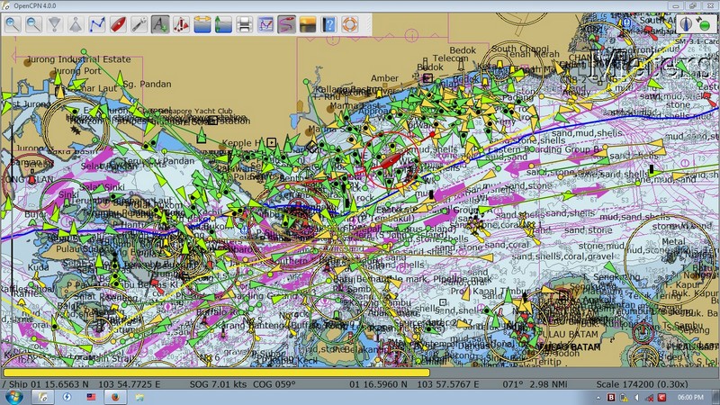
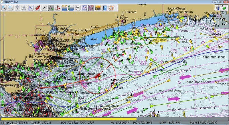
Even the Vesper Marine AIS was almost useless there were so many targets. It was most useful feeding the AIS into OpenCPN, but neither laptop I had was happy with so much activity on the USB bus. (Not quite sure what was going on, but it was frustrating. I kept getting USB Device Not Recognized--not sure if it was heat or too much activity, or both). (Several days later I discovered that the problems were caused by a very "noisy" inverter. Once I turned the inverter off, I never had another USB serial port problem, but we were gone from Singapore by then)

We made it safely into the anchorage in Malaysian waters on the east side of Singapore by 5pm, and were joined by our friends on Migration. We have been following Migration ever since we got in the Pacific-always a year or two behind them. But they just finished a 2 year refit in Thailand (which Bruce DOESN'T recommend), and so we finally got to meet them in person.
We rowed over to their boat for happy hour on their voluminous (trimaran) deck. The boat is gorgeous--so the refit was successful in the end (it's a 45 year old 46 ft Cross tri, but now looks brand new).
We left this anchorage yesterday morning and headed on our 702 nm trip to Labuan, on the coast of Borneo. There is lots to see in Borneo that we are skipping by, including the Rainforest Festival near Kuching. But we just can't see everything.
We are in the SW Monsoon season, so the winds are southerly. Since we got clear of the channel and turned the engines off, we've been sailing at 7-8 knots. We put one reef in the main when the daily wind came up, and another in this morning in squally weather. And we're still doing 7 knots. We have about 530 NM to go to Labuan.
With a 3rd person on board, watches and sailhandling have been easy. Kevin has been very useful in helping us figure out all the boat systems. (I have a blog half-written about all that stuff, but want to get the passage report in...)
All is well, ETA Labuan Wednesday afternoon local time, if we keep this speed up. (But softer wind is in the forecast).
----------
radio email processed by SailMail
for information see: http://www.sailmail.com
Subscribe to:
Posts (Atom)