We are all tucked up in a nice marina...Holiday Ocean View Marina on the garden island of Samal, off the coast of Davao in Mindanao in the Philippines.
We got checked in yesterday...Thanks to Stephen on Westward II spending all day with us yesterday taking us through the process.
To get from the marina to downtown, we have to take a free shuttle bus, a free ferry, and then a jeepney ride to town. It takes about an hour. And then "whoosh!" first world madness with the Philippine chaos thrown in (similar to the big cities we have been to in South and Central America). One whole floor of the huge mall was only electronics gadgets.
We got simmed yesterday... sims for our two phones and one for the internet onboard. Hopefully I'll get a chance to get everything updated soon... but there's a lot going on--hard to find time.
We are officially shopping for an air conditioner and maybe a used motorcycle.
At 08/05/2014 10:28 PM (utc) our position was 07°11.84'N 125°42.64'E
http://svsoggypaws.com/currentposition.htm
Friday, August 8, 2014


Monday, August 4, 2014
My Computer Lives!
Yesterday afternoon in a particularly "boisterous" patch of weather, my ASUS Eee PC (which was not properly secured) launched itself off the nav station onto the floor, with a few pieces flying. It was not on, thank god. But Dave, who picked up the pieces, was sure it was toast.
The little blinking light that indicates "standby mode" was still blinking, so I was hopeful that it might still be alive. When I first tried to start it up, I got a scary disk error (OH CRAP!). But after re-seating the disk drive in it's socket, it started up. Thank God for small favors!!
I am well prepared for disaster recovery--you absolutely have to be on a boat. Just the salt air will kill a computer in a year or two--one little teeny salt water drip can be fatal--not to mention hauling the computer all over creation in a backpack, and the "at sea" encounters like yesterday.
I keep pretty good back-ups, and I have a spare computer I could migrate to, but the last time I backed up was about a week ago. And who has time to re-create one's life on different computer, no matter how good your back up is??
This little cheapo ($350) computer that I bought in 2009 has been such an incredible buy. I wish I'd bought 2 or 3 of them. We have bought 2 of its successors, also called Eee PC's, but not nearly as well built. I'd like the same case, same keyboard with a faster processor, more memory (mine is limited to 2GB) and a bigger HD... for the same $300 price range. Too bad the company has "upgraded" their PC line.
The little blinking light that indicates "standby mode" was still blinking, so I was hopeful that it might still be alive. When I first tried to start it up, I got a scary disk error (OH CRAP!). But after re-seating the disk drive in it's socket, it started up. Thank God for small favors!!
I am well prepared for disaster recovery--you absolutely have to be on a boat. Just the salt air will kill a computer in a year or two--one little teeny salt water drip can be fatal--not to mention hauling the computer all over creation in a backpack, and the "at sea" encounters like yesterday.
I keep pretty good back-ups, and I have a spare computer I could migrate to, but the last time I backed up was about a week ago. And who has time to re-create one's life on different computer, no matter how good your back up is??
This little cheapo ($350) computer that I bought in 2009 has been such an incredible buy. I wish I'd bought 2 or 3 of them. We have bought 2 of its successors, also called Eee PC's, but not nearly as well built. I'd like the same case, same keyboard with a faster processor, more memory (mine is limited to 2GB) and a bigger HD... for the same $300 price range. Too bad the company has "upgraded" their PC line.
In the Philippines
We are happy to report that we rounded Cape San Augustine this morning at 0845 and we are officially in Philippine waters.
The marina we are headed for (Holiday Ocean View in Samal, near Davao) is too far away to reach in one day, so we needed to find a stopping place overnight. You don't sail at night in coastal waters in the Philippines--too many FADs, fishermen, nets, etc.
With S-SW winds, none of the anchorages we had marked along the west coast of the SE peninsula in Mindenao were looking very good. We picked out one--at Sigaboy Island--that looked like it might work, but the wind was too far south. The only spot where there were anchoring depths was not behind the island with the south-ish winds we had. And about the time we were looking, the winds had picked up and were howling through the area, with a bit of a venturi effect near the island. So we moved on.
A few miles north, Dave picked out a decent anchorage in a big cove, I think called something like Baksal Cove. We anchored at 06-40.6N / 126-04.9E, in about 25 feet of water, off a fishing village. "Off a fishing village" is an interesting term in the Philippines, as pretty much every bay we went by on our 25 miles up the coast, had a fishing village. Basically a row of shacks along the beach with 20-40 motorized outrigger canoes pulled up on the beach.
The Filipinos are incredible. It's hard to convey their fishing-ness. Several hundred miles off the coast of Mindanao, in very deep water, our friends on Carina passed a "FAD" with a medium-sized (say, 30-40') fishing boat accompanied by a number of outrigger canoes. And we saw them in all shapes and sizes today...anything from a one-man canoe to a giant community-sized fishing or transport vessel. Here they are called "bancas" (bong-kas)...outlandish looking trimaran things with motorized propulsion (pictures to follow).
We are getting up at the crack of dawn tomorrow (even Dave!) to make the last 40 miles to the marina.
-----
At 08/04/2014 12:40 PM (utc) our position was 06°40.60'N 126°04.90'E
http://svsoggypaws.com/currentposition.htm
The marina we are headed for (Holiday Ocean View in Samal, near Davao) is too far away to reach in one day, so we needed to find a stopping place overnight. You don't sail at night in coastal waters in the Philippines--too many FADs, fishermen, nets, etc.
With S-SW winds, none of the anchorages we had marked along the west coast of the SE peninsula in Mindenao were looking very good. We picked out one--at Sigaboy Island--that looked like it might work, but the wind was too far south. The only spot where there were anchoring depths was not behind the island with the south-ish winds we had. And about the time we were looking, the winds had picked up and were howling through the area, with a bit of a venturi effect near the island. So we moved on.
A few miles north, Dave picked out a decent anchorage in a big cove, I think called something like Baksal Cove. We anchored at 06-40.6N / 126-04.9E, in about 25 feet of water, off a fishing village. "Off a fishing village" is an interesting term in the Philippines, as pretty much every bay we went by on our 25 miles up the coast, had a fishing village. Basically a row of shacks along the beach with 20-40 motorized outrigger canoes pulled up on the beach.
The Filipinos are incredible. It's hard to convey their fishing-ness. Several hundred miles off the coast of Mindanao, in very deep water, our friends on Carina passed a "FAD" with a medium-sized (say, 30-40') fishing boat accompanied by a number of outrigger canoes. And we saw them in all shapes and sizes today...anything from a one-man canoe to a giant community-sized fishing or transport vessel. Here they are called "bancas" (bong-kas)...outlandish looking trimaran things with motorized propulsion (pictures to follow).
We are getting up at the crack of dawn tomorrow (even Dave!) to make the last 40 miles to the marina.
-----
At 08/04/2014 12:40 PM (utc) our position was 06°40.60'N 126°04.90'E
http://svsoggypaws.com/currentposition.htm
Sunday, August 3, 2014
Bashing the House to Weather
For you non-sailors, the term "To Weather" means to go into the wind and waves.
Here we are enroute to the Philippines now on Day 4. This is definitely getting old. We have finally reached the "favorable" current (south-bound), which makes it easier to make the heading we need to get around the point. But the southbound current against the northbound wind has made the seas really short and steep. So we are bashing and crashing--big sheets of salt water coming over the bow. My tomato plants are definitely NOT happy. And neither are we.
Fortunately, we made the right decision in motorsailing further south to reach lighter winds. We have better weather here, while two of the purist-sailor boats that left with us were "hove to" this morning in 20-30 knots (temporary squall conditions). While they sneer at our wimpy-ness, we know they are wishing they were where we are.
There is a typhoon that was just forming as we left Palau, and was supposed to track off to the northwest and not be a factor. It has stalled about 600 miles north of us and turned into a "Super Typhoon". This is making what looked like an ideal weather window... 12-15 knots... into a less than ideal window. We've had 15-20 all day and it's clocked a little to be more on our nose, and the forecast is for it to continue like this for at least another day.
But because we've been motorsailing for two days now, we are now less than 24 hours from rounding the point (God willin' and the creek don't rise), and then we'll be in more protected waters and going with the wind and the current--and only 60 miles from our destination. We probably won't make it all the way into the marina tomorrow, but will likely stop somewhere to rest up and make it into the marina on an easy day on Tuesday.
We spotted our first FAD this morning. It was a large day-glo orange cylinder in 6,000 METERS of water (~18,000 feet). We can't imagine them being anchored... they MUST be just launched and floating. But what a hazard to navigation! They are typically made out of steel and are roughly the size of a refrigerator. In calm weather with a good radar, you might be able to pick them up on radar, but not in these seas (and not with our tired old radar mounted on the arch).
We're in no danger, just discomfort. We have 3 other boats out here with us to commiserate with, and a number of boats waiting for us at the marina in Samal with a cold beer. We're just ready for it to be over.
-----
At 08/03/2014 12:24 AM (utc) our position was 06°51.15'N 127°55.53'E
http://svsoggypaws.com/currentposition.htm
Here we are enroute to the Philippines now on Day 4. This is definitely getting old. We have finally reached the "favorable" current (south-bound), which makes it easier to make the heading we need to get around the point. But the southbound current against the northbound wind has made the seas really short and steep. So we are bashing and crashing--big sheets of salt water coming over the bow. My tomato plants are definitely NOT happy. And neither are we.
Fortunately, we made the right decision in motorsailing further south to reach lighter winds. We have better weather here, while two of the purist-sailor boats that left with us were "hove to" this morning in 20-30 knots (temporary squall conditions). While they sneer at our wimpy-ness, we know they are wishing they were where we are.
There is a typhoon that was just forming as we left Palau, and was supposed to track off to the northwest and not be a factor. It has stalled about 600 miles north of us and turned into a "Super Typhoon". This is making what looked like an ideal weather window... 12-15 knots... into a less than ideal window. We've had 15-20 all day and it's clocked a little to be more on our nose, and the forecast is for it to continue like this for at least another day.
But because we've been motorsailing for two days now, we are now less than 24 hours from rounding the point (God willin' and the creek don't rise), and then we'll be in more protected waters and going with the wind and the current--and only 60 miles from our destination. We probably won't make it all the way into the marina tomorrow, but will likely stop somewhere to rest up and make it into the marina on an easy day on Tuesday.
We spotted our first FAD this morning. It was a large day-glo orange cylinder in 6,000 METERS of water (~18,000 feet). We can't imagine them being anchored... they MUST be just launched and floating. But what a hazard to navigation! They are typically made out of steel and are roughly the size of a refrigerator. In calm weather with a good radar, you might be able to pick them up on radar, but not in these seas (and not with our tired old radar mounted on the arch).
We're in no danger, just discomfort. We have 3 other boats out here with us to commiserate with, and a number of boats waiting for us at the marina in Samal with a cold beer. We're just ready for it to be over.
-----
At 08/03/2014 12:24 AM (utc) our position was 06°51.15'N 127°55.53'E
http://svsoggypaws.com/currentposition.htm
Saturday, August 2, 2014
On the Way to Philippines - Day 3
We were having a great sail, but going slowly in the wrong direction, and Dave just wants to "Get 'er done" and get there.
So yesterday afternoon, after a long discussion between Dave (the motorhead) and me (the sailor) we cranked the engine up and started motorsailing directly toward Cabo San Augustine, the SE point of land on Mindenao that we have to round to get up into the Gulf of Davao.
Also, the best wisdom in strong current is to make all speed directly across the current, to get out of it sooner, so that's what we're doing. Our current plan is to keep heading WSW until we strike the favorable southbound current, and then tack over and head south in the favorable current. But the plan changes with every new forecast.
There's another typhoon brewing well to the north of us, and what looked like a nice settled weather window is looking less settled as the typhoon spins us. So Dave's "let's quit playing around out here and get there" is somewhat justified.
Also, we got wind of an anchor-chain re-galvinizing expedition in Davao, our destination. To get in on that, we have to be at the marina by Tuesday evening. If we keep motorsailing we'll just barely make it. (saving lots of money on chain/re-galvanizing but spending about $3/hr on diesel fuel).
One other factor out here I forgot to mention. The Filipino fisherman fish offshore in small boats up to 180 nm from the coast. So once we get that close to shore, we have to keep watch for possibly unlit/unmarked FAD's (fish aggregating devices). They can be anything from a wooden raft to large metal cylinders, and anchored out in deep water. We have waypoints for ones that have been spotted by others, so we know about where they start appearing.
The fishermen are also out fishing at night along the coast in small unlit boats, often with nets. So you can't do coastal passages around here at night--another reason why we decided to stay offshore, rather than head for the coast and then creep along in the protection of the coast.
We're using RTOFS requests from Saildocs to get the current information. Last time I tried it (about 6 years ago), I didn't get anything, but now I do--a 3-day forecast for what they expect the current to do. It is a GRIB file just like the GFS forecast gribs, and can be viewed in OpenCPN or ViewFax.
Anyway, all is well out here, and we're "only" 215 nm from rounding Cabo San Augustine, and then it's 60 miles or so to the marina.
-----
Sherry & Dave
Heading west across Micronesia in 2014
http://svsoggypaws.blogspot.com
At 08/02/2014 1:07 AM (utc) our position was 07°10.44'N 129°38.39'E
http://svsoggypaws.com/currentposition.htm
So yesterday afternoon, after a long discussion between Dave (the motorhead) and me (the sailor) we cranked the engine up and started motorsailing directly toward Cabo San Augustine, the SE point of land on Mindenao that we have to round to get up into the Gulf of Davao.
Also, the best wisdom in strong current is to make all speed directly across the current, to get out of it sooner, so that's what we're doing. Our current plan is to keep heading WSW until we strike the favorable southbound current, and then tack over and head south in the favorable current. But the plan changes with every new forecast.
There's another typhoon brewing well to the north of us, and what looked like a nice settled weather window is looking less settled as the typhoon spins us. So Dave's "let's quit playing around out here and get there" is somewhat justified.
Also, we got wind of an anchor-chain re-galvinizing expedition in Davao, our destination. To get in on that, we have to be at the marina by Tuesday evening. If we keep motorsailing we'll just barely make it. (saving lots of money on chain/re-galvanizing but spending about $3/hr on diesel fuel).
One other factor out here I forgot to mention. The Filipino fisherman fish offshore in small boats up to 180 nm from the coast. So once we get that close to shore, we have to keep watch for possibly unlit/unmarked FAD's (fish aggregating devices). They can be anything from a wooden raft to large metal cylinders, and anchored out in deep water. We have waypoints for ones that have been spotted by others, so we know about where they start appearing.
The fishermen are also out fishing at night along the coast in small unlit boats, often with nets. So you can't do coastal passages around here at night--another reason why we decided to stay offshore, rather than head for the coast and then creep along in the protection of the coast.
We're using RTOFS requests from Saildocs to get the current information. Last time I tried it (about 6 years ago), I didn't get anything, but now I do--a 3-day forecast for what they expect the current to do. It is a GRIB file just like the GFS forecast gribs, and can be viewed in OpenCPN or ViewFax.
Anyway, all is well out here, and we're "only" 215 nm from rounding Cabo San Augustine, and then it's 60 miles or so to the marina.
-----
Sherry & Dave
Heading west across Micronesia in 2014
http://svsoggypaws.blogspot.com
At 08/02/2014 1:07 AM (utc) our position was 07°10.44'N 129°38.39'E
http://svsoggypaws.com/currentposition.htm
Friday, August 1, 2014
Off We Go to The Philippines
We had originally planned to stay in Palau until September, but the weather in the last month has really been poor. We haven't had one chance in 4-5 weeks to get out and go diving. The "Monsoon Winds" have arrived, and the Monsoon Trough has sat over Palau for weeks, bringing SW winds, rain and squally weather. The monsoon wind blows primarily from the SW--directly on the best part of the reef.
We have also tired of being cooped up in the one anchorage we are permitted to stay in without paying $100 for a 10-day cruising permit.
Anyway, after yet another bout of crappy weather, we have decided to cut our stay short and leave when our friends leave on this weather window. (one boat has been trying to leave for a month, and this is the first good window) We didn't want to take the chance of getting stuck for another month.
The flip side is, we'll be in Davao for their big festival in mid-August, and we have signed up to participate in the first part of the Indonesia Rally leaving from Davao around the 1st of September.
There's a lot of stuff we did in Palau that was blog-worthy. The internet is just so slow and expensive that I never got to it. Hopefully we'll get a chance to back-post, at least with some highlights.
We left Palau 2 days ago, and are now about 290 miles from the easternmost point of Mindenao, the biggest island on the SE side of the Philippines. We are trying to get to a place on the N end of the small island of Samal, off the big city of Davao, in southern Mindenao. There is a marina there called the Holiday Ocean View Marina at approx 07-11.87 N / 125-42.62 E. This is where we plan to leave Soggy Paws for our next trip home.
We are hard on the wind in 10-12 knots of wind, and bucking a .5kt current right now. There is a bigger current coming--the current running south along the coast of Mindenao peaks at 2.8kts!! (Think Gulfstream). To complicate our weather routing situation, just about the time we get to the strong current, we will have almost 20kts of opposing winds. This is not a good situation. So we are looking at t-t-t-tacking around a bit trying to balance staying out of the strong adverse current and the strong adverse winds--and especially out of the strong-current-against-strong-winds situation. (Think Gulfstream in a Cold Front).
So far it's been a very nice sail. But the next few days are going to get rough. Though it's only 295 miles straight to the coast, it's nearly 400 miles to the point we have to round to get up into the Gulf of Davao. And we won't be able to do it in a straight line.
Fortunately the weather in general is pretty settled, so at least we don't have to worry about 30 kt squalls in the mix.
We are in loose company with 3 other boats who left at the same time--Carina, Helena, and La Gitana. Westward II left for Davao a couple of weeks ago, and Challenger is stored in Palau, with Jerry in NC for a little while longer. New friends on Miss Behave set out the day before we did, on their way back to Australia via PNG and Vanuatu.
P.S. Our website was down for a couple of days--we apparently got hacked--but it should be back up now. Also, I think I fixed the position report widget on the blog--so that should be working again.
-----
At 08/01/2014 1:45 AM (utc) our position was 07°26.12'N 131°21.37'E
http://svsoggypaws.com/currentposition.htm
We have also tired of being cooped up in the one anchorage we are permitted to stay in without paying $100 for a 10-day cruising permit.
Anyway, after yet another bout of crappy weather, we have decided to cut our stay short and leave when our friends leave on this weather window. (one boat has been trying to leave for a month, and this is the first good window) We didn't want to take the chance of getting stuck for another month.
The flip side is, we'll be in Davao for their big festival in mid-August, and we have signed up to participate in the first part of the Indonesia Rally leaving from Davao around the 1st of September.
There's a lot of stuff we did in Palau that was blog-worthy. The internet is just so slow and expensive that I never got to it. Hopefully we'll get a chance to back-post, at least with some highlights.
We left Palau 2 days ago, and are now about 290 miles from the easternmost point of Mindenao, the biggest island on the SE side of the Philippines. We are trying to get to a place on the N end of the small island of Samal, off the big city of Davao, in southern Mindenao. There is a marina there called the Holiday Ocean View Marina at approx 07-11.87 N / 125-42.62 E. This is where we plan to leave Soggy Paws for our next trip home.
We are hard on the wind in 10-12 knots of wind, and bucking a .5kt current right now. There is a bigger current coming--the current running south along the coast of Mindenao peaks at 2.8kts!! (Think Gulfstream). To complicate our weather routing situation, just about the time we get to the strong current, we will have almost 20kts of opposing winds. This is not a good situation. So we are looking at t-t-t-tacking around a bit trying to balance staying out of the strong adverse current and the strong adverse winds--and especially out of the strong-current-against-strong-winds situation. (Think Gulfstream in a Cold Front).
So far it's been a very nice sail. But the next few days are going to get rough. Though it's only 295 miles straight to the coast, it's nearly 400 miles to the point we have to round to get up into the Gulf of Davao. And we won't be able to do it in a straight line.
Fortunately the weather in general is pretty settled, so at least we don't have to worry about 30 kt squalls in the mix.
We are in loose company with 3 other boats who left at the same time--Carina, Helena, and La Gitana. Westward II left for Davao a couple of weeks ago, and Challenger is stored in Palau, with Jerry in NC for a little while longer. New friends on Miss Behave set out the day before we did, on their way back to Australia via PNG and Vanuatu.
P.S. Our website was down for a couple of days--we apparently got hacked--but it should be back up now. Also, I think I fixed the position report widget on the blog--so that should be working again.
-----
At 08/01/2014 1:45 AM (utc) our position was 07°26.12'N 131°21.37'E
http://svsoggypaws.com/currentposition.htm
Friday, July 11, 2014
Reef Diving in Palau
We have now made two 10-day trips out to the Rock Islands of Palau. On the first trip, we were mostly diving on the SW and West reef, between German Channel and Saies Corner. On the second trip, we did a lot of diving on the Japanese wrecks left over from World War II (covered in the next blog post).

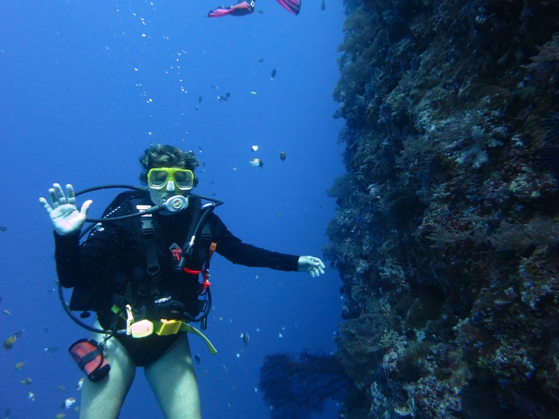
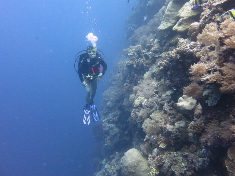
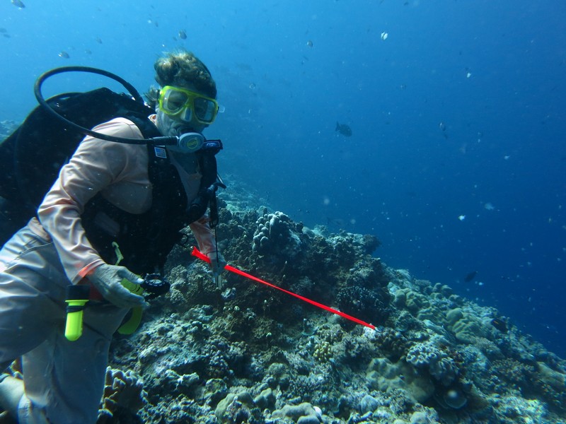
Sherry on the Blue Corner Wall
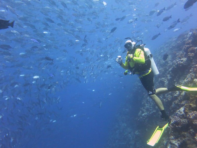
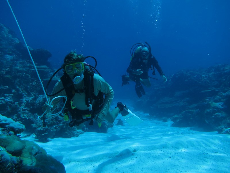
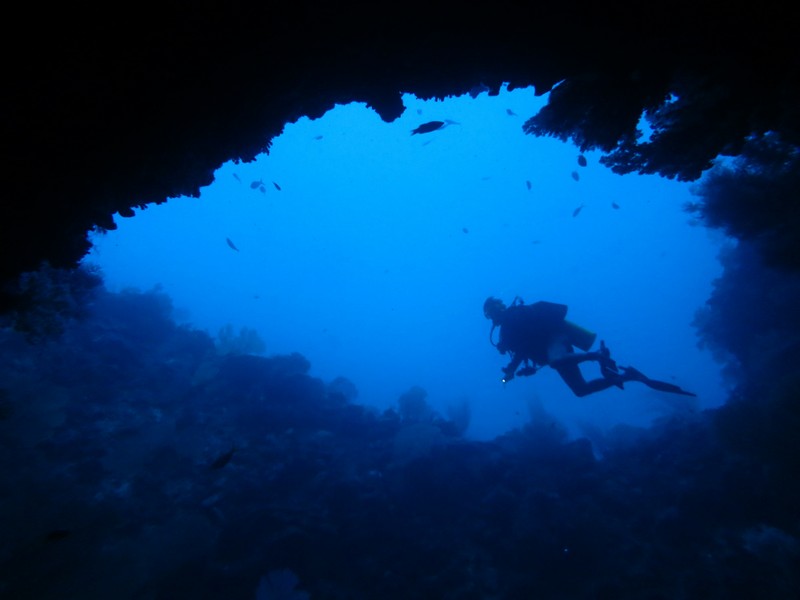
Below are the best of the photos from our reef diving. Most of them were taken by my husband Dave.
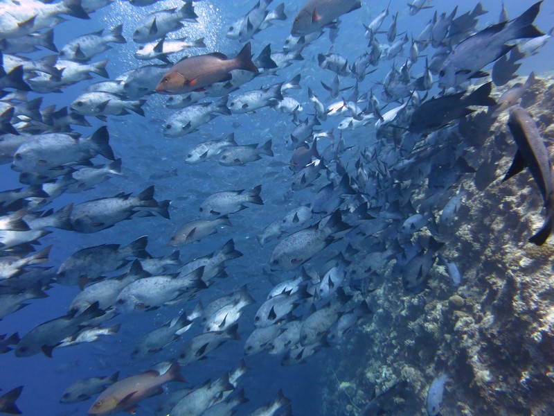
The signature dive for Palau is Blue Corner, which is just one spot on the reef. But in reality, there are about 5 miles of reef on the SW side of the Palau archipelago that have just incredible diving. Incredible because of the clarity of the water and the huge amount of fish life--caused by a combination of current outside the reef and environments conducive to marine hatcheries inside the reef... and stringent protection regulations.

Huge School of Snapper Hanging Out at Blue Corner

Stephen from Westward II Watching the Action

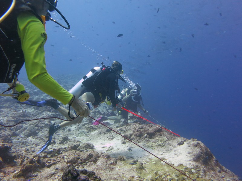
Using Our Reef Hooks to Hang on the Wall

Sharks Too!


A Big Moray On Top Of The Wall
The people who manage diving tourism in Palau have done a great job of making the dive sites accessible without damaging the reef. They have a string of dive buoys all along the reef.

Another Huge School of Fish at New Dropoff

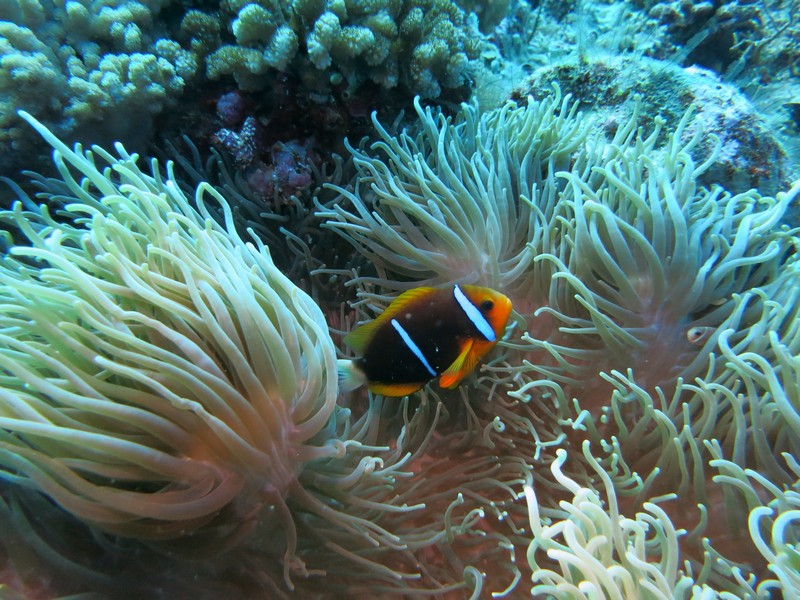
We Found Nemo!

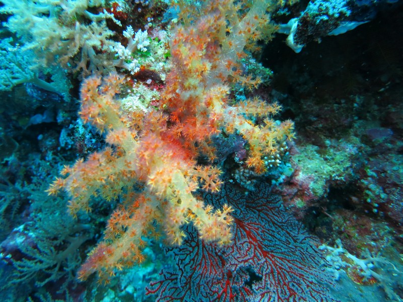
The Soft Corals Like the Current, Too

The New Dropoff Wall
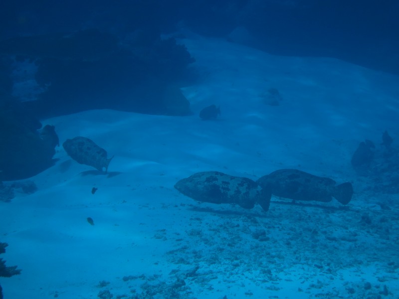
Besides the SW reef area, there are several channel dives. These are drift dives in the channel, usually on the incoming current. The best one is Ulong Channel, and we have done this several times. During May and June the Grouper are spawning, and they are all over in Ulong Channel. Other popular channel dives are German Channel and Lighthouse Channel.
For a few dives, Jerry from Challenger volunteered to be "dinghy tender". This was quite a luxury for us. Makes things much easier on current dives to know there is someone on the surface following your bubbles, no matter where you end up.

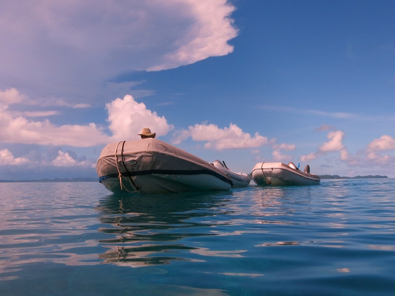
Jerry With Three Dinghies
On other dives, we towed the dinghies with us. This is possible when there are no other divers or dive boats to worry about, and when there's not much wind.

Sherry Drifting with the Dinghy While Dave Takes Pictures

Grouper Spawning in Ulong Channel (There were hundreds of them 18"-24" long)
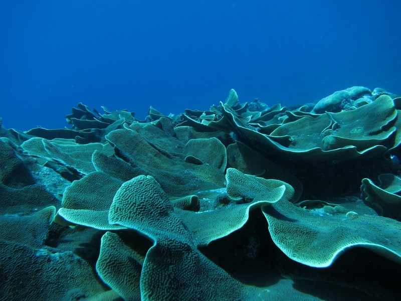
Awesome Spread of Lettuce Coral in Ulong Channel
There were lots of other very cool things to see in Ulong Channel, but it all happens pretty fast as we are drifting along at 1-2 knots. I really like the garden eels, but they are very hard to get a picture of. They are only about 8-10" long and sink into their holes in the sand when you approach. They look like turtle grass unless you look carefully.
Near Ulong Channel is a very nice no-current reef dive called Coral Gardens. This is a great place to take a novice diver as it is shallow and easy, with lots of pretty fish and coral.

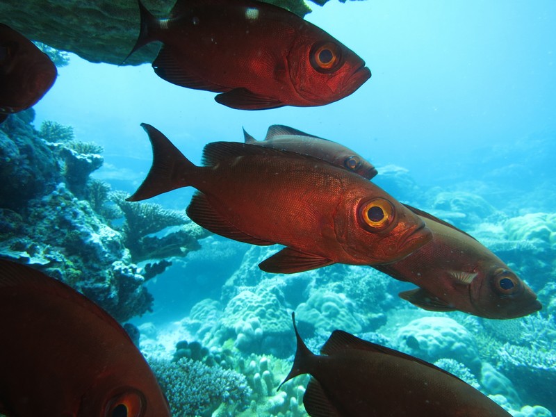
Big Eye Fish Hanging Out in the Shade of a Large Plate Coral
Further out from Ulong Channel is Saies Tunnels and Saies Corner. It's a long dinghy ride (3-4 miles), but doable in our RIBs with 15-25 HP motors. In the early morning (half tide or greater to get over the reef) with no wind, it's an exhilarating ride. And totally worth it.

Interesting Caves at Saies Tunnels

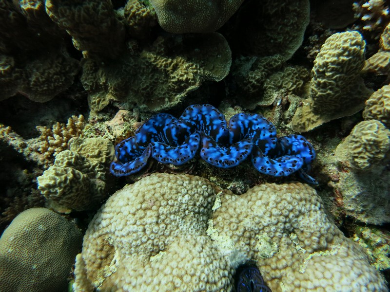
Colorful Tridacna Clam

Hanging Out in the Current at Saies Corner

Eagle Ray

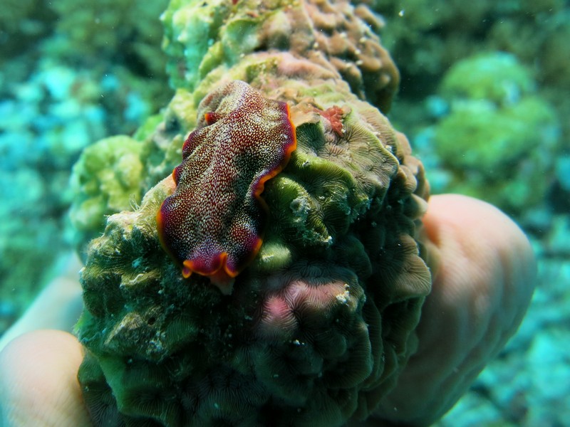
A Rather Large Nudibranch We Found in German Channel
The only problem with all this "resource management" is that it ends up being very expensive to cruise here. The $120 you pay on arrival as a cruiser is just the beginning. To go and anchor ANYWHERE except the single designated cruiser anchorage at Sam's Tours, it costs $50 per month for a Cruising Permit for the boat, and $50 per person for a 10-day Rock Islands permit.
So the first excursion out to the Rock Islands costs a whopping $150 for 10 days, and another $100 for another 10 days. Plus, there has been almost no wind (good for diving, bad for sailing), and so we've had to motor everywhere, and diesel is $5.45/gallon.
But it's better than paying the fly-in tourist diver rate of $145 per diver per day for a two-tank dive (plus of course, hotel, meals and transportation).
In my next installment, I'll post some pics of the wrecks we have seen.
Below are the best of the photos from our reef diving. Most of them were taken by my husband Dave.
The signature dive for Palau is Blue Corner, which is just one spot on the reef. But in reality, there are about 5 miles of reef on the SW side of the Palau archipelago that have just incredible diving. Incredible because of the clarity of the water and the huge amount of fish life--caused by a combination of current outside the reef and environments conducive to marine hatcheries inside the reef... and stringent protection regulations.
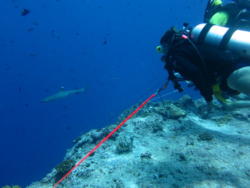
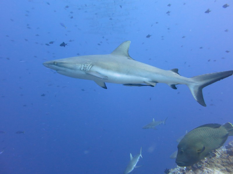
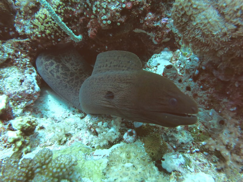
The people who manage diving tourism in Palau have done a great job of making the dive sites accessible without damaging the reef. They have a string of dive buoys all along the reef.
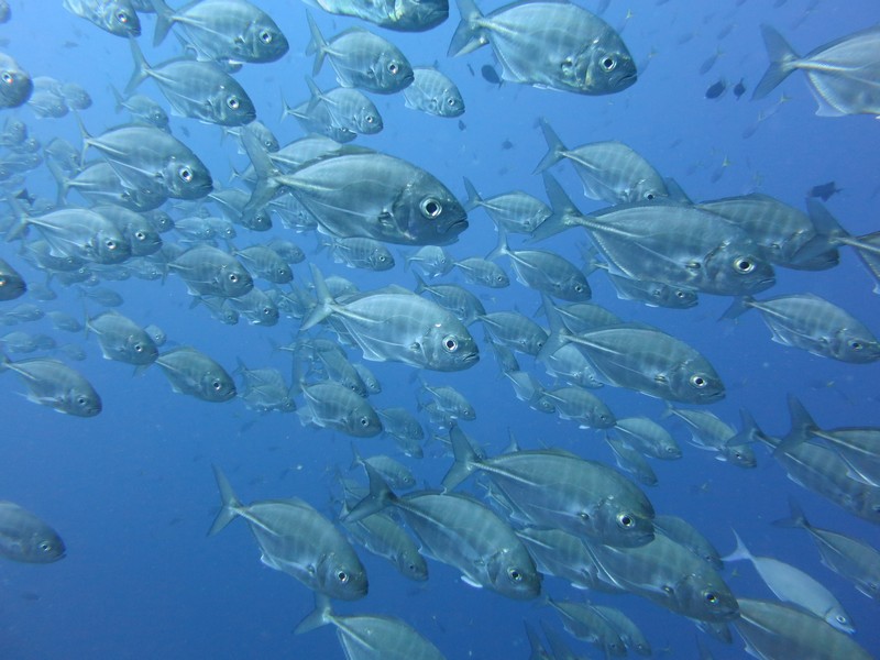
Besides the SW reef area, there are several channel dives. These are drift dives in the channel, usually on the incoming current. The best one is Ulong Channel, and we have done this several times. During May and June the Grouper are spawning, and they are all over in Ulong Channel. Other popular channel dives are German Channel and Lighthouse Channel.
For a few dives, Jerry from Challenger volunteered to be "dinghy tender". This was quite a luxury for us. Makes things much easier on current dives to know there is someone on the surface following your bubbles, no matter where you end up.
On other dives, we towed the dinghies with us. This is possible when there are no other divers or dive boats to worry about, and when there's not much wind.
There were lots of other very cool things to see in Ulong Channel, but it all happens pretty fast as we are drifting along at 1-2 knots. I really like the garden eels, but they are very hard to get a picture of. They are only about 8-10" long and sink into their holes in the sand when you approach. They look like turtle grass unless you look carefully.
Near Ulong Channel is a very nice no-current reef dive called Coral Gardens. This is a great place to take a novice diver as it is shallow and easy, with lots of pretty fish and coral.
Further out from Ulong Channel is Saies Tunnels and Saies Corner. It's a long dinghy ride (3-4 miles), but doable in our RIBs with 15-25 HP motors. In the early morning (half tide or greater to get over the reef) with no wind, it's an exhilarating ride. And totally worth it.

The only problem with all this "resource management" is that it ends up being very expensive to cruise here. The $120 you pay on arrival as a cruiser is just the beginning. To go and anchor ANYWHERE except the single designated cruiser anchorage at Sam's Tours, it costs $50 per month for a Cruising Permit for the boat, and $50 per person for a 10-day Rock Islands permit.
So the first excursion out to the Rock Islands costs a whopping $150 for 10 days, and another $100 for another 10 days. Plus, there has been almost no wind (good for diving, bad for sailing), and so we've had to motor everywhere, and diesel is $5.45/gallon.
But it's better than paying the fly-in tourist diver rate of $145 per diver per day for a two-tank dive (plus of course, hotel, meals and transportation).
In my next installment, I'll post some pics of the wrecks we have seen.
Wednesday, June 4, 2014
Enjoying Palau
We have been in Palau for 3-4 weeks now. I have been really remiss in not posting, but we just been so busy!!
We have settled in at Sam's Tours--one of the most yacht-friendly non-yacht businesses we have encountered in 7 years of cruising. For $35 we joined the Royal Belau Yacht Club (essentially based at Sam's), which entitles us to use the dinghy dock, trash disposal, hot water showers, secure bike rack, AND get a 10% discount at dive shop and the bar/restaurant. We joined on arrival, and have contracted for a nicely-maintained mooring for $50/mo.
Sam's is primarily a dive operator, but they also arrange eco-tours, etc. They are incredibly busy in the mornings and late afternoons. But once the divers are away in the dive boats, by about 9:30 in the morning, it is a great place to hang out. The managers and helpers--when they aren't overwhelmed by their diver-handling duties--are incredibly friendly and helpful. They have already several times gone out of their way to help us out.
The anchorage is in a nice setting--we are essentially in one of Palau's quirky "Rock Islands" and surrounded by nature, in a fairly protected (but deep) location. It has fairly clear water, and is swimable. In fact there is a cave dive (Chandelier Cave) located right next to the mooring field, and in the late afternoons, there are 2-3 dive boats hanging outside the cave waiting for divers to return.
They speak Palauan and English here, and use the U.S. dollar as their currency. When Americans check in on their boats, they are asked, "How long would you like to stay?"...in other words, like the Marshall Islands, no visa hassles. (not so for non-Americans, unfortunately).
Sam's/RBYC is also a secure and easy place to have mail packages sent. Like the Marshalls, Palau has a U.S. Post Office zip code, and so you can have mail sent from the U.S. via USPS. Priority Mail packages don't cost very much to send, and they get here normally in a week to 10 days.
We have been hearing about the grocery stores here ever since we started reading up on Palau. There are 3 big stores, well stocked with both American and world-wide goods. There is a fairly large Asian contingent in Palau, so lots of small Asian stores as well. Due to the flourishing tourism business, daily flights bring daily replenishment of the veggies. So there seems to always be reasonably fresh-looking broccoli and lettuce on the shelves, and usually some decent tomatoes.
There are also two American brand hardware stores here... a Do-It-Best and an Ace, both well stocked.
There are several restaurants within easy walking distance of the anchorage, and "town" is a $5 taxi ride away, with a few more restaurants. So between eating out and eating in, we've been eating quite well!!
"Town" is, unfortunately not in easy walking distance of the anchorage. At high tide you could get there by long dinghy ride, but there are no dinghy dock facilities there. The alternatives are a $5 taxi ride each way (for up to 4 people), bicycles, or hitch a ride with Sam's on their morning run to pick up divers from the hotels. We have unloaded the folding bikes we bought in Hawaii (for the first time in 3 years!), and have been using them for getting around. Our friends on Carina bought a pair of bikes from another cruiser who was leaving. Jerry on Challenger bought a bike from a local store for about $150. The rest of the cruisers here have been carpooling with taxis, or occasionally walking. (Usually you only try to walk once, then you take an air-conditioned taxi).
We have great pay-as-you go internet in the anchorage. But the downside is that it's not cheap, and it's very slow. With the booming tourism business here, the internet pipeline is not adequate to accommodate the number of people trying to connect. In the middle of the day, even with a strong wifi signal, you are lucky to get a fairly complex page like Amazon to even complete loading. Forget trying to download ANYTHING bigger than 100Kb.
There seems to be no magic way around the speed issue, except to get up and do your internet business in the middle of the night. For this, the worst internet service we've had since the Marquesas, we pay about $1.25 per hour (via $10 for 7 hour scratch-off cards). If you buy your scratch-off cards in bulk (10 at a time), the price comes down to $8 per 7 hours. Due to the slow speeds, even getting up at 6am to do my surfing, I burned through $80 in a week, and have contemplated going on a monthly plan at $175 per month (unlimited time)! This is one reason I haven't been blogging or Facebooking much! Not only is it expensive, everything on the internet takes 2-5 times longer to complete.
I have heard that the Palau government is trying to upgrade their internet trunk line, but I haven't heard any hard dates, so it's probably "not this year". So we are stuck with the situation until we move on to the Philippines in September. I've heard the internet is better and easier there.
Another downside to Palau is that everything in general is a little pricey on a cruiser's budget. This is due to Palau being a tourist destination, plus being way out in the Western Pacific. It's not quite as bad as French Polynesia, but similar to Hawaii and big-city-American prices. The prices wouldn't be shocking for someone flying in from the U.S., but with the very cheap Philippines just over the horizon, some of our cruiser friends are complaining. Some examples... meals out are $7-25, with around $8-10 the norm. Liquor is probably the worst--there must be some hefty liquor taxes here. The cheapest bottle of wine you can find in a grocery store (what would be a $4 bottle in the U.S.) is about $12. We have yet to find any boxed wine. The cheapest beer we have found is $1.05 per can, and that's Milwaukee's Best or Japanese Asahi. They have a local micro-brewery that brews some really nice beer, and that's $1.75/can. Hard liquor is outrageous--the cheapest most rot-gut vodka is about $25 per bottle (what would be $5-7 in the U.S.), and everything else is more expensive.
A third major downside to Palau is that non-American visitors are only given a one-month visa, and then must extend monthly at about $100 per month per person. So our non-American cruising buddies are only staying a month and then moving on to the Philippines.
It seems like everyone on this cruising route is heading for the Philippines. The cruiser grapevine says that, if you avoid the bad spots (like Zamboanga, a hotbed of Muslim separatist activity), it's a great cruising destination and very inexpensive to cruise, and to get work done on your boat. Somewhat like Venezuela was before it (recently) got so bad.
This is long enough... I'll stop here and get this off before I get re-prioritized. I promise to fill in some more in the next few days.
We have settled in at Sam's Tours--one of the most yacht-friendly non-yacht businesses we have encountered in 7 years of cruising. For $35 we joined the Royal Belau Yacht Club (essentially based at Sam's), which entitles us to use the dinghy dock, trash disposal, hot water showers, secure bike rack, AND get a 10% discount at dive shop and the bar/restaurant. We joined on arrival, and have contracted for a nicely-maintained mooring for $50/mo.
Sam's is primarily a dive operator, but they also arrange eco-tours, etc. They are incredibly busy in the mornings and late afternoons. But once the divers are away in the dive boats, by about 9:30 in the morning, it is a great place to hang out. The managers and helpers--when they aren't overwhelmed by their diver-handling duties--are incredibly friendly and helpful. They have already several times gone out of their way to help us out.
The anchorage is in a nice setting--we are essentially in one of Palau's quirky "Rock Islands" and surrounded by nature, in a fairly protected (but deep) location. It has fairly clear water, and is swimable. In fact there is a cave dive (Chandelier Cave) located right next to the mooring field, and in the late afternoons, there are 2-3 dive boats hanging outside the cave waiting for divers to return.
They speak Palauan and English here, and use the U.S. dollar as their currency. When Americans check in on their boats, they are asked, "How long would you like to stay?"...in other words, like the Marshall Islands, no visa hassles. (not so for non-Americans, unfortunately).
Sam's/RBYC is also a secure and easy place to have mail packages sent. Like the Marshalls, Palau has a U.S. Post Office zip code, and so you can have mail sent from the U.S. via USPS. Priority Mail packages don't cost very much to send, and they get here normally in a week to 10 days.
We have been hearing about the grocery stores here ever since we started reading up on Palau. There are 3 big stores, well stocked with both American and world-wide goods. There is a fairly large Asian contingent in Palau, so lots of small Asian stores as well. Due to the flourishing tourism business, daily flights bring daily replenishment of the veggies. So there seems to always be reasonably fresh-looking broccoli and lettuce on the shelves, and usually some decent tomatoes.
There are also two American brand hardware stores here... a Do-It-Best and an Ace, both well stocked.
There are several restaurants within easy walking distance of the anchorage, and "town" is a $5 taxi ride away, with a few more restaurants. So between eating out and eating in, we've been eating quite well!!
"Town" is, unfortunately not in easy walking distance of the anchorage. At high tide you could get there by long dinghy ride, but there are no dinghy dock facilities there. The alternatives are a $5 taxi ride each way (for up to 4 people), bicycles, or hitch a ride with Sam's on their morning run to pick up divers from the hotels. We have unloaded the folding bikes we bought in Hawaii (for the first time in 3 years!), and have been using them for getting around. Our friends on Carina bought a pair of bikes from another cruiser who was leaving. Jerry on Challenger bought a bike from a local store for about $150. The rest of the cruisers here have been carpooling with taxis, or occasionally walking. (Usually you only try to walk once, then you take an air-conditioned taxi).
We have great pay-as-you go internet in the anchorage. But the downside is that it's not cheap, and it's very slow. With the booming tourism business here, the internet pipeline is not adequate to accommodate the number of people trying to connect. In the middle of the day, even with a strong wifi signal, you are lucky to get a fairly complex page like Amazon to even complete loading. Forget trying to download ANYTHING bigger than 100Kb.
There seems to be no magic way around the speed issue, except to get up and do your internet business in the middle of the night. For this, the worst internet service we've had since the Marquesas, we pay about $1.25 per hour (via $10 for 7 hour scratch-off cards). If you buy your scratch-off cards in bulk (10 at a time), the price comes down to $8 per 7 hours. Due to the slow speeds, even getting up at 6am to do my surfing, I burned through $80 in a week, and have contemplated going on a monthly plan at $175 per month (unlimited time)! This is one reason I haven't been blogging or Facebooking much! Not only is it expensive, everything on the internet takes 2-5 times longer to complete.
I have heard that the Palau government is trying to upgrade their internet trunk line, but I haven't heard any hard dates, so it's probably "not this year". So we are stuck with the situation until we move on to the Philippines in September. I've heard the internet is better and easier there.
Another downside to Palau is that everything in general is a little pricey on a cruiser's budget. This is due to Palau being a tourist destination, plus being way out in the Western Pacific. It's not quite as bad as French Polynesia, but similar to Hawaii and big-city-American prices. The prices wouldn't be shocking for someone flying in from the U.S., but with the very cheap Philippines just over the horizon, some of our cruiser friends are complaining. Some examples... meals out are $7-25, with around $8-10 the norm. Liquor is probably the worst--there must be some hefty liquor taxes here. The cheapest bottle of wine you can find in a grocery store (what would be a $4 bottle in the U.S.) is about $12. We have yet to find any boxed wine. The cheapest beer we have found is $1.05 per can, and that's Milwaukee's Best or Japanese Asahi. They have a local micro-brewery that brews some really nice beer, and that's $1.75/can. Hard liquor is outrageous--the cheapest most rot-gut vodka is about $25 per bottle (what would be $5-7 in the U.S.), and everything else is more expensive.
A third major downside to Palau is that non-American visitors are only given a one-month visa, and then must extend monthly at about $100 per month per person. So our non-American cruising buddies are only staying a month and then moving on to the Philippines.
It seems like everyone on this cruising route is heading for the Philippines. The cruiser grapevine says that, if you avoid the bad spots (like Zamboanga, a hotbed of Muslim separatist activity), it's a great cruising destination and very inexpensive to cruise, and to get work done on your boat. Somewhat like Venezuela was before it (recently) got so bad.
This is long enough... I'll stop here and get this off before I get re-prioritized. I promise to fill in some more in the next few days.
Sunday, May 18, 2014
Passage from Yap to Palau
May 6 - May 8, 2014
We checked out of Yap on the morning of our departure. The Yap officials would not permit us to check out late the afternoon before and leave at the crack of dawn, as we had wanted to. So we had to wait until their office opened at 8am to check out. But it was done quickly and painlessly and without cost. We made one last stop at the grocery store--hoping that tomatoes would have magically appeared on the shelves. But alas, we had to make our passage tomato-free.
As seems to have been the pattern during our whole trip across Micronesia, we left port on another long passage with the promise of wind that never materialized.
And also true to form, Dave didn't want to drift along in the light winds, so we motored a lot of the way to Palau.
The entire trip was pretty uneventful. We spent most of the second day with passing squalls and doing the zero-to-25-to-zero squall "two step". But about midnight that day, the final squall passed and our last 12 hours was pretty good.
The whole passage was 260 miles, from the anchorage in Yap to the commercial wharf in Palau. It took us 53 hours, and we motored 31 hours of that.
Our check-in in Palau was pretty hassle-free. We tied up to the commercial wharf at 1pm, and by about 3pm, we were completely done. The whole thing cost $150 U.S. And as Americans, we have a year in Palau before we need to worry about a visa extension. (Non-Americans get 1 month, extendable to 3 at a cost of about $100 per month).
By 3:30pm we were on the Guest Mooring off Sam's Tours, and by 5pm we were enjoying a nice cold draft Red Rooster beer (great German beer brewed in Palau) at the bar at Sams. Hot showers, nice dinghy dock, etc.
-----
At 05/08/2014 9:17 PM (utc) our position was 07°20.32'N 134°27.17'E
We checked out of Yap on the morning of our departure. The Yap officials would not permit us to check out late the afternoon before and leave at the crack of dawn, as we had wanted to. So we had to wait until their office opened at 8am to check out. But it was done quickly and painlessly and without cost. We made one last stop at the grocery store--hoping that tomatoes would have magically appeared on the shelves. But alas, we had to make our passage tomato-free.
As seems to have been the pattern during our whole trip across Micronesia, we left port on another long passage with the promise of wind that never materialized.
And also true to form, Dave didn't want to drift along in the light winds, so we motored a lot of the way to Palau.
The entire trip was pretty uneventful. We spent most of the second day with passing squalls and doing the zero-to-25-to-zero squall "two step". But about midnight that day, the final squall passed and our last 12 hours was pretty good.
The whole passage was 260 miles, from the anchorage in Yap to the commercial wharf in Palau. It took us 53 hours, and we motored 31 hours of that.
Our check-in in Palau was pretty hassle-free. We tied up to the commercial wharf at 1pm, and by about 3pm, we were completely done. The whole thing cost $150 U.S. And as Americans, we have a year in Palau before we need to worry about a visa extension. (Non-Americans get 1 month, extendable to 3 at a cost of about $100 per month).
By 3:30pm we were on the Guest Mooring off Sam's Tours, and by 5pm we were enjoying a nice cold draft Red Rooster beer (great German beer brewed in Palau) at the bar at Sams. Hot showers, nice dinghy dock, etc.
-----
At 05/08/2014 9:17 PM (utc) our position was 07°20.32'N 134°27.17'E
A Week in Yap
April 28 - May 6, 2014
Yap... where the heck is that? When a cruising friend of ours stopped in Yap a few years ago, I had never heard of it. And still couldn't find it on the map, until we started planning our cruising for this year.

Our Trek Across Micronesia, Highlighting Yap
Yap is an Island/Atoll/State in the NW part of the Federated States of Micronesia (FSM). It is located at 09-30.87 N / 138-07.35 E, 450 Miles SW of Guam.
We found Yap to be an interesting contrast to the other populated centers in the FSM (Chuuk/Truk and Pohnpei). Though Yap is pretty sleepy, we found infrastructure and orderliness that we hadn't expected. Compared to the infrastructure disaster that Chuuk is, Yap really has its act together. There are trash bins and recycling boxes on the street corners--and they are actually USED by the local people. There is hardly any trash lying around.

Road Signs to Help Tourists
A huge number of miles of roads are paved and in good condition, and even the remote dirt roads are maintained. The villages--both ones that the tourists visit on their "culture tour" and the more remote ones--are neat and orderly. People work hard to keep their own grounds clean, and the roadside in their villages. While we were out driving around, we saw several "work crews" from a nearby village out picking up trash along the road. These people are in no way similar to what we saw in Chuuk.
We only stayed 8 days in Yap--we kind of got the "horse headed to the barn syndrome", and pushed on to Palau pretty quickly. But we did get to see a lot of Yap, thanks mainly to Marie and Glen from Backbeat.
Of course, after check-in, my first priority was groceries and Dave's first priority was seeing the World War II stuff. Diving ended up a distant 3rd--the reports on diving Yap were so-so and we knew we were soon moving on to Palau with GREAT diving. We took care of groceries on the first day there, then set out to see as much of Yap as possible.

Yap Visitor's Bureau (Struggling for Funding)
Philip and Leslie on Carina (cruising friends that had stayed 2 months in Yap) had told Dave to be sure to look up Tom at the Yap Visitor's Bureau (YVB), and this turned out to be a great tip. Tom is a native Yapese who has gotten as bitten by the World War II bug as Dave is. Tom has been one of primary members of the Yap end of the team for MissingAirCrew.com.

Tom Tamangmow from YVB, Showing Us Their WWII Memorials
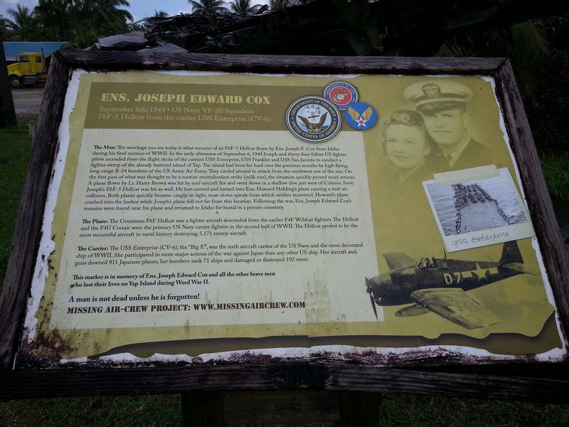
Because of Dave's interest in World War II stuff, Tom loaded us up in a 4WD and took us out to show us what Pat from MissingAirCrew.com and Tom and the YVB have been working on--monuments to downed US Airmen in Yap.

Dave in Tom's Office, Sharing Photos of Micronesian WWII Sites
Pat Ranfranz, back in the U.S., does the research as to planes that went down while bombing Yap. Then he sends Tom out to try to find the plane. Pat also tries to visit Yap at least once a year to do some searching on his own. They have found a lot of them, but they are still looking for a few. We got Glen from Backbeat turned on to this, and he's signed up for a personal mission to try to locate the remains of one specific plane that still has not been found.

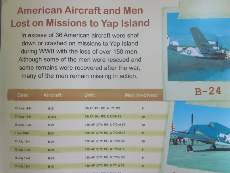
MissingAirCrew.com's List of US Planes Lost Over Yap
The U.S. bombed Yap nearly daily during 1944/45. There were never any plans to invade, but they wanted to keep the Japanese airfield and airplanes unusable. At one point, the Japanese (or Yapese) spelled out on the runway "We Give Up, Please Don't Bomb Any More". (sorry I can't locate this picture, but I think there is a copy of it somewhere on the MissingAircrew.com website).

One of the Plaques for Downed U.S. Airmen in Yap
So we got a quickie tour of the close sites by Tom from YVB.
But then Glen and Marie loaded us up in their car and spent two afternoons showing us the rest of the island. We stopped at a bunch of Japanese relics that Glen and Marie had found on their own while out wandering around, plus the best of the "Stone Money Banks". We took waypoints on our GPS for every "Point of Interest" we found, because one of the things that the Yap Visitors Bureau lacks is a good map showing the exact location of all these attractions.

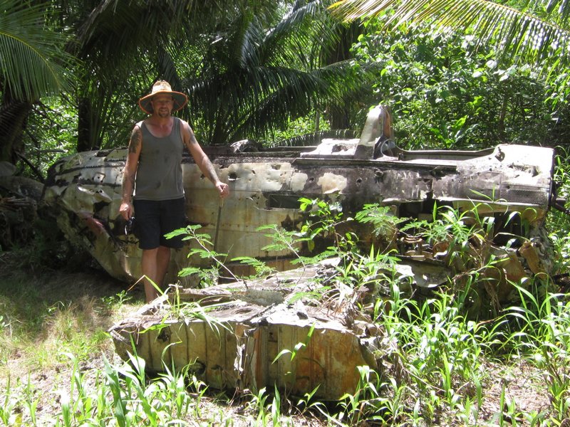
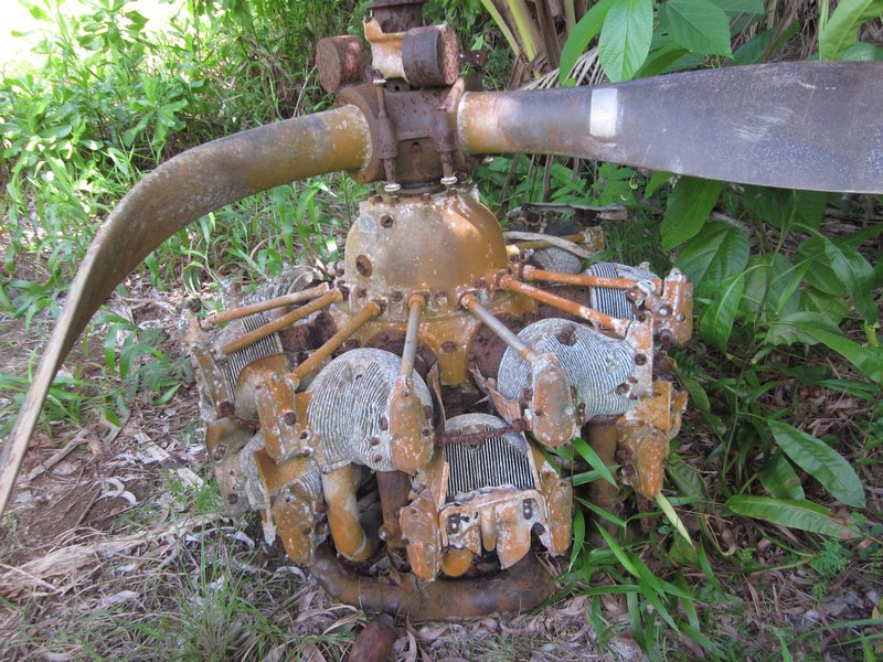
Glen Shows Us a Plane He Found Near the Old Runway


A Bullet Hole in the Cockpit Seat

As an example, there is a plaque placed by YVB at the former Japanese lighthouse. Tom had showed us a picture of it, and Dave wanted to go see it. But it's not on any map that we could find in Yap. Fortunately, we got a waypoint from Tom, because we would have never ever found it otherwise.

Japanese Light House, On Its Side

Destroyed by the Japanese, So the US Would Stop Using It For Target Practice
It is way out in the boonies on a dirt road, with no signs marking the way. There was once a road that went all the way to the lighthouse, but now the road peters out, and we ended up parking the car and walking the last mile or so (we had to ask permission to park there from a local, and get directions). And when we got very close (according to the GPS), we still couldn't see the lighthouse and couldn't figure out where it was. It turned out to be a short scramble up a hill, through the jungle. The reason it's not very visible is that the entire structure is now prone in the jungle. The story we heard was that the Japanese pulled the lighthouse down themselves--they were tired of getting bombed every day by U.S. forces.

One Typical Example of Yap Stone Money
Stone Money is unique to Yap (and maybe Palau). The Yapese would send canoes to Palau to a special place with some special stone, and quarry these circular stones. They were used as money in Yap (and still are, to a limited extent, in traditional Yapese culture today). We were told that the value of a given stone is not based on the quality of the stonework, nor the type of stone, but more by the story of its voyage from Palau to Yap--how dangerous the trip was, how many men and boats were lost, etc.

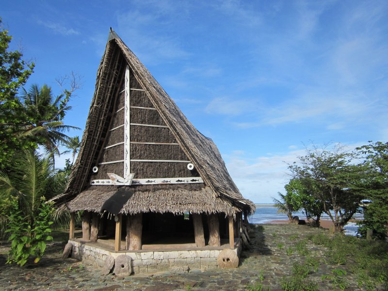
Village "Money Bank" Centered Around the Men's House

Traditional "Men's House" in Yap
In the mid-1800's an enterprising Irish-American trader, trying to get the Yapese to gather Copra (dried coconut) for him, started bringing stone money from Palau in his trading ships. His colorful exploits were written up in a somewhat fictionalized book called "His Majesty O'Keefe". This was eventually made into a Burt Lancaster movie of the same name (we haven't seen it).
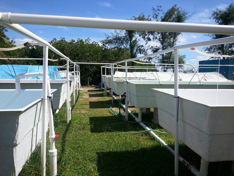
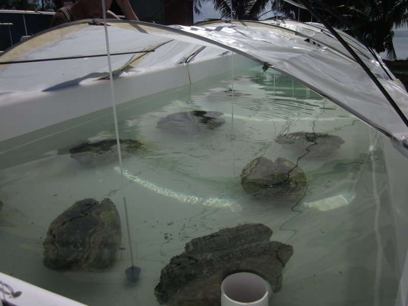
We also stopped by a Clam Farm, where a Belgian guy is trying to grow Giant Clams.

Cultivating the Giant Clam

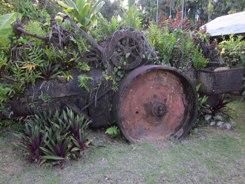
On our way through one village, we saw an old steam-powered roller, rusting in someone's backyard.

Steam Powered Road Construction Equipment - An Heirloom!
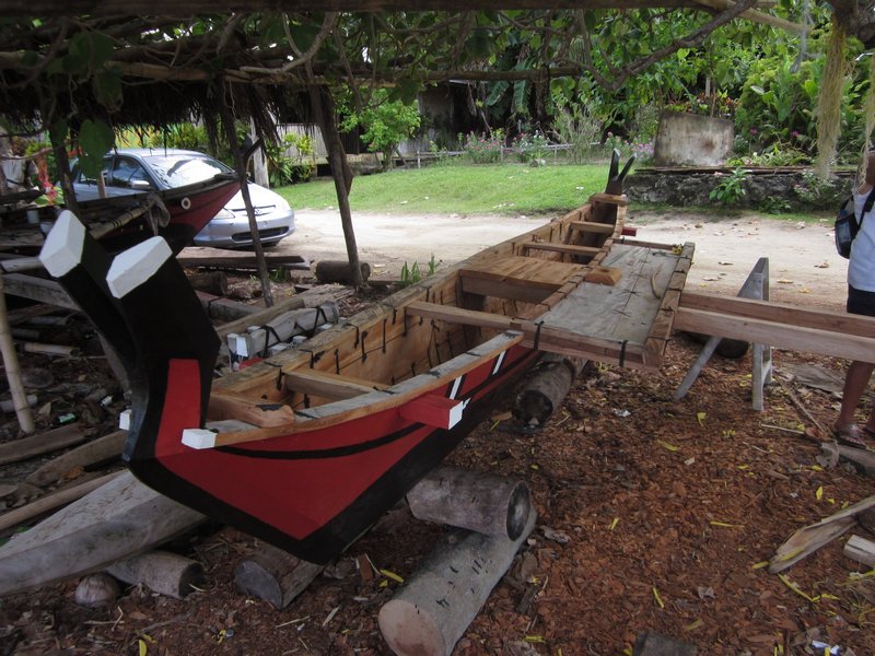
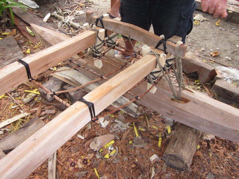
We also got a chance to get an up-close look at a one-man version of a Yap canoe. The entire thing is constructed only of natural materials--no nails, screws, or high tech glue.

A Yapese One-Man Outrigger Canoe

Note the Lashings to Hold Everything Together
We didn't do any diving in Yap. We had heard that the Manta Ray dive was fabulous, but we were past Manta season. And we knew Palau would have better diving.
Having seen most of what Yap has to offer in our short week, we said good bye and good luck to Backbeat, and move on to catch up with our friends who were all in Palau by now.
For more on Yap, see our friends on s/v Lorelei's Blog. They spent a lot more time in Yap than we did. And did some diving there, too.
Yap... where the heck is that? When a cruising friend of ours stopped in Yap a few years ago, I had never heard of it. And still couldn't find it on the map, until we started planning our cruising for this year.
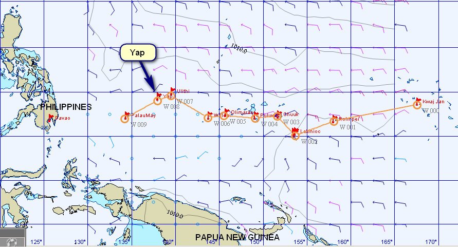
Yap is an Island/Atoll/State in the NW part of the Federated States of Micronesia (FSM). It is located at 09-30.87 N / 138-07.35 E, 450 Miles SW of Guam.
We found Yap to be an interesting contrast to the other populated centers in the FSM (Chuuk/Truk and Pohnpei). Though Yap is pretty sleepy, we found infrastructure and orderliness that we hadn't expected. Compared to the infrastructure disaster that Chuuk is, Yap really has its act together. There are trash bins and recycling boxes on the street corners--and they are actually USED by the local people. There is hardly any trash lying around.

A huge number of miles of roads are paved and in good condition, and even the remote dirt roads are maintained. The villages--both ones that the tourists visit on their "culture tour" and the more remote ones--are neat and orderly. People work hard to keep their own grounds clean, and the roadside in their villages. While we were out driving around, we saw several "work crews" from a nearby village out picking up trash along the road. These people are in no way similar to what we saw in Chuuk.
We only stayed 8 days in Yap--we kind of got the "horse headed to the barn syndrome", and pushed on to Palau pretty quickly. But we did get to see a lot of Yap, thanks mainly to Marie and Glen from Backbeat.
Of course, after check-in, my first priority was groceries and Dave's first priority was seeing the World War II stuff. Diving ended up a distant 3rd--the reports on diving Yap were so-so and we knew we were soon moving on to Palau with GREAT diving. We took care of groceries on the first day there, then set out to see as much of Yap as possible.
Philip and Leslie on Carina (cruising friends that had stayed 2 months in Yap) had told Dave to be sure to look up Tom at the Yap Visitor's Bureau (YVB), and this turned out to be a great tip. Tom is a native Yapese who has gotten as bitten by the World War II bug as Dave is. Tom has been one of primary members of the Yap end of the team for MissingAirCrew.com.
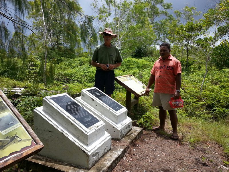
Because of Dave's interest in World War II stuff, Tom loaded us up in a 4WD and took us out to show us what Pat from MissingAirCrew.com and Tom and the YVB have been working on--monuments to downed US Airmen in Yap.
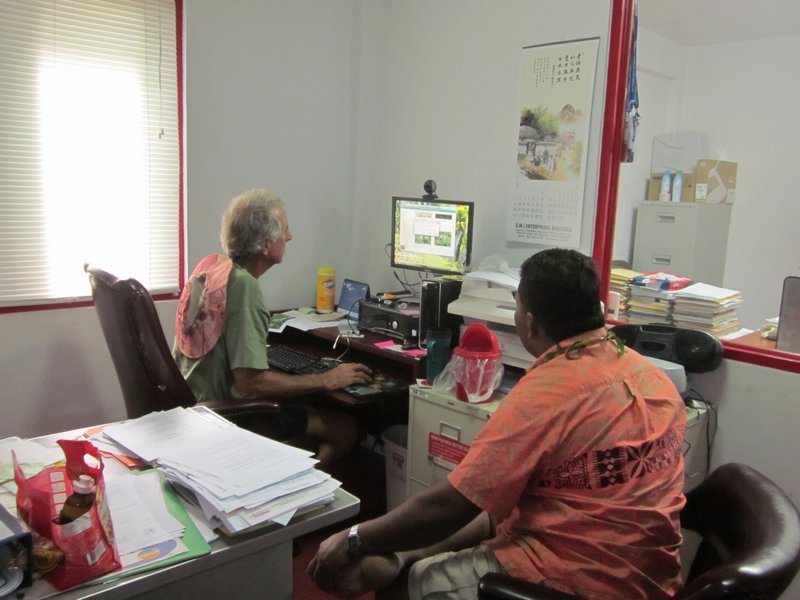
Pat Ranfranz, back in the U.S., does the research as to planes that went down while bombing Yap. Then he sends Tom out to try to find the plane. Pat also tries to visit Yap at least once a year to do some searching on his own. They have found a lot of them, but they are still looking for a few. We got Glen from Backbeat turned on to this, and he's signed up for a personal mission to try to locate the remains of one specific plane that still has not been found.
The U.S. bombed Yap nearly daily during 1944/45. There were never any plans to invade, but they wanted to keep the Japanese airfield and airplanes unusable. At one point, the Japanese (or Yapese) spelled out on the runway "We Give Up, Please Don't Bomb Any More". (sorry I can't locate this picture, but I think there is a copy of it somewhere on the MissingAircrew.com website).
So we got a quickie tour of the close sites by Tom from YVB.
But then Glen and Marie loaded us up in their car and spent two afternoons showing us the rest of the island. We stopped at a bunch of Japanese relics that Glen and Marie had found on their own while out wandering around, plus the best of the "Stone Money Banks". We took waypoints on our GPS for every "Point of Interest" we found, because one of the things that the Yap Visitors Bureau lacks is a good map showing the exact location of all these attractions.
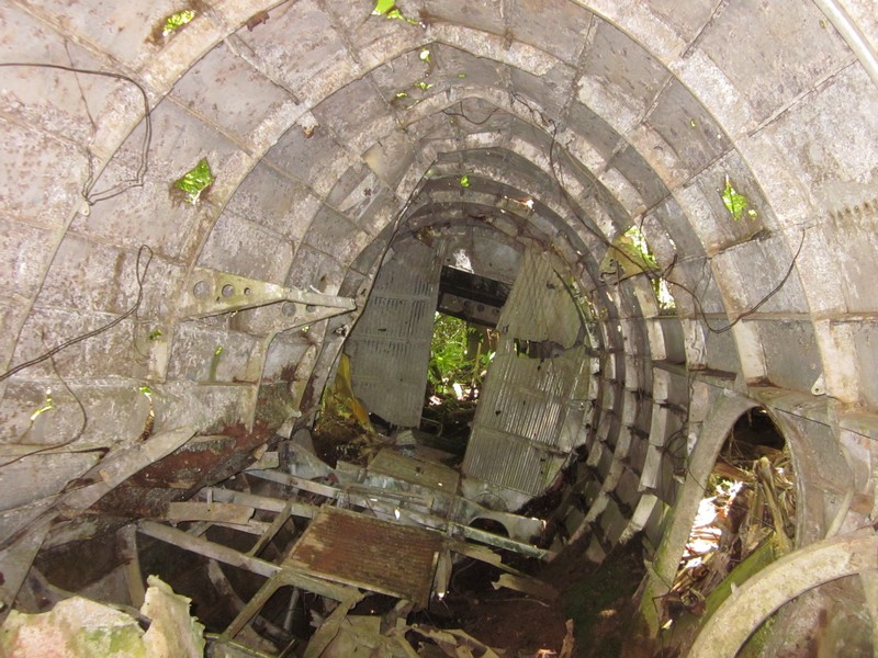
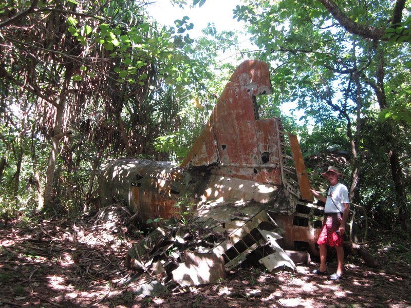
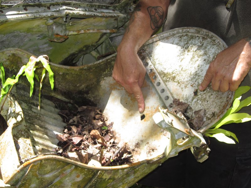
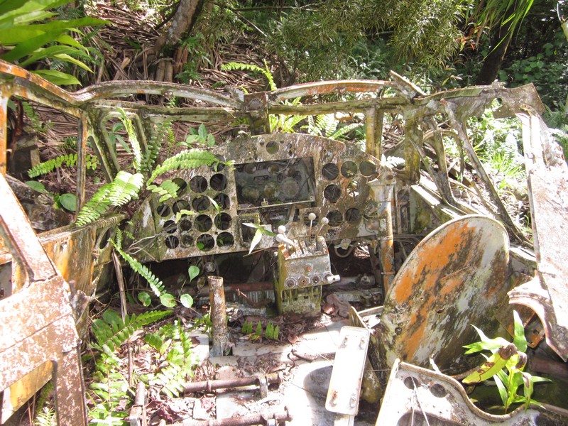
As an example, there is a plaque placed by YVB at the former Japanese lighthouse. Tom had showed us a picture of it, and Dave wanted to go see it. But it's not on any map that we could find in Yap. Fortunately, we got a waypoint from Tom, because we would have never ever found it otherwise.
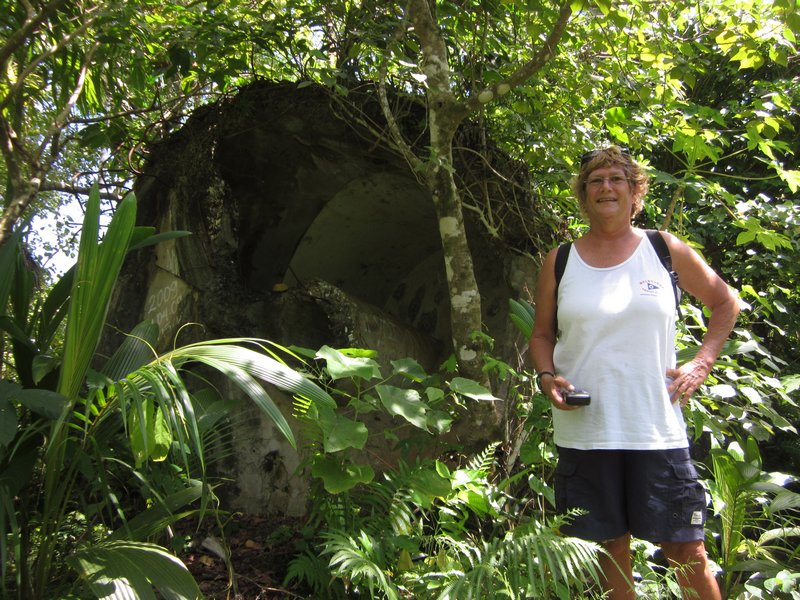
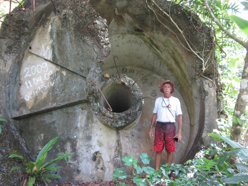
It is way out in the boonies on a dirt road, with no signs marking the way. There was once a road that went all the way to the lighthouse, but now the road peters out, and we ended up parking the car and walking the last mile or so (we had to ask permission to park there from a local, and get directions). And when we got very close (according to the GPS), we still couldn't see the lighthouse and couldn't figure out where it was. It turned out to be a short scramble up a hill, through the jungle. The reason it's not very visible is that the entire structure is now prone in the jungle. The story we heard was that the Japanese pulled the lighthouse down themselves--they were tired of getting bombed every day by U.S. forces.
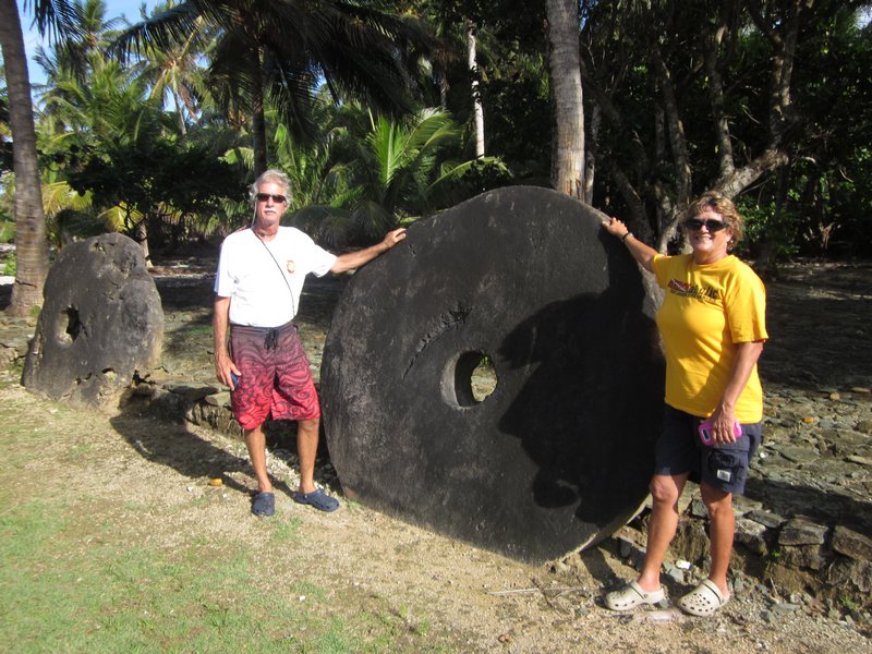
Stone Money is unique to Yap (and maybe Palau). The Yapese would send canoes to Palau to a special place with some special stone, and quarry these circular stones. They were used as money in Yap (and still are, to a limited extent, in traditional Yapese culture today). We were told that the value of a given stone is not based on the quality of the stonework, nor the type of stone, but more by the story of its voyage from Palau to Yap--how dangerous the trip was, how many men and boats were lost, etc.
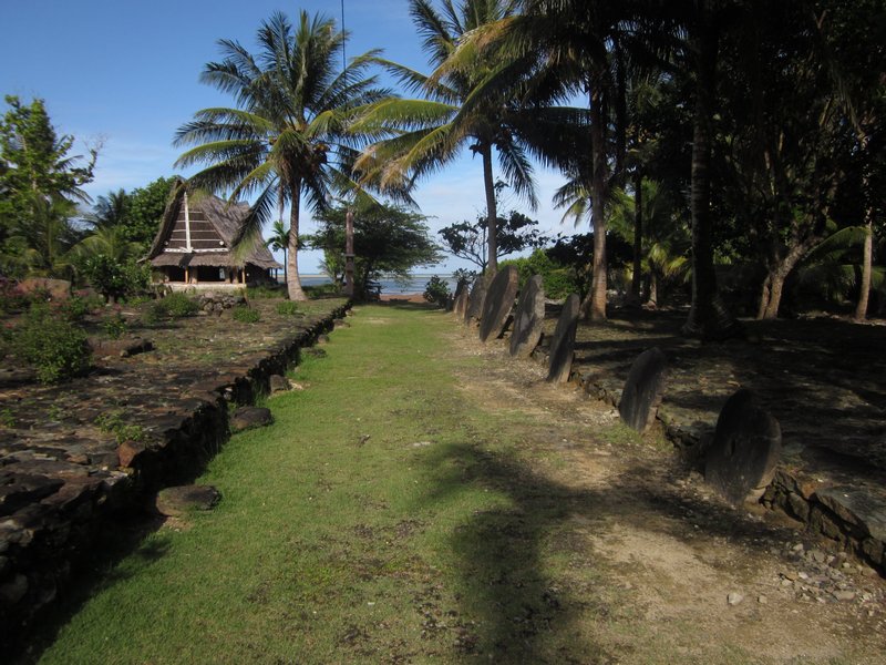
In the mid-1800's an enterprising Irish-American trader, trying to get the Yapese to gather Copra (dried coconut) for him, started bringing stone money from Palau in his trading ships. His colorful exploits were written up in a somewhat fictionalized book called "His Majesty O'Keefe". This was eventually made into a Burt Lancaster movie of the same name (we haven't seen it).
We also stopped by a Clam Farm, where a Belgian guy is trying to grow Giant Clams.
On our way through one village, we saw an old steam-powered roller, rusting in someone's backyard.
We also got a chance to get an up-close look at a one-man version of a Yap canoe. The entire thing is constructed only of natural materials--no nails, screws, or high tech glue.
We didn't do any diving in Yap. We had heard that the Manta Ray dive was fabulous, but we were past Manta season. And we knew Palau would have better diving.
Having seen most of what Yap has to offer in our short week, we said good bye and good luck to Backbeat, and move on to catch up with our friends who were all in Palau by now.
For more on Yap, see our friends on s/v Lorelei's Blog. They spent a lot more time in Yap than we did. And did some diving there, too.
Subscribe to:
Posts (Atom)