After a slow start, we finally left Kwajalein Atoll about noon yesterday, sailing wing-on-wing out through Gea Pass.
We had a fairly slow first 24 hours--the wind that was forecast at 15-17 was more like 10-15 kts. Going downwind, that doesn't leave much wind in our sails. But light wind and reasonable seas were fine with us, and it was nice to have an easy day to get back in the swing of things.
We are in our usual downwind configuration--Genoa poled out on the windward side, mainsail vanged on the other side, and the staysail sheeted tight on the same side as the main. This configuration works well with the wind vane steering, and gives us about 30 degrees of steering flexibility without having to do a bunch of messing with the sails.
This is the first passage in a long while that we haven't had another boat or two along to keep us company. We haven't seen nor heard another soul on the VHF or AIS since we left Kwaj yesterday--it's a pretty lonely spot of ocean. Except of course for all our buddies strung across the Marshall Islands and Micronesia--we talk to them every morning on the SSB net.
The forecast is for the wind to gradually build in strength over the next day as a high passes by above us. The forecast is for winds to 21 knots--hopefully it doesn't get any higher than that. 15-20 is about perfect for downwind sailing, but higher gets pretty challenging because of the size of the seas that build up. With the stronger winds, our speed should pick up to about 6.5 knots, and if that happens, we might be in by Weds afternoon. Otherwise, it will be Thursday morning.
-----
At 02/02/2014 8:00 AM (utc) our position was 08°14.42'N 165°10.86'E
Sunday, February 2, 2014


Friday, January 31, 2014
Getting Ready to Leave the Marshall Islands
January 31 - Kwajalein Atoll
We did it! We untied from the Kwajalein Small Boat Marina dock yesterday.
We had a great two weeks at Kwaj. We worked our butts off to get the boat ready (and still have a long list of undone things). And we managed to squeeze in some diving and a lot of socializing.
Our relatively new friend Geoff was a fantastic host. We spent almost every evening after dinner at his "quarters" (not unlike a dorm room, but Geoff has two adjoined), taking hot showers, having a spot of rum, and talking about a wide range of subjects--from life on Kwaj to cruising to boat maintenance to diving to world travel, to retirement plans (in Singapore, Geoff says).
My main tasks in the two weeks were to (a) Get the bottom scrubbed (b) Stock the boat (c) Repair the mainsail cover (d) Help Dave wherever needed. I spent a week laboring over the sewing machine in the picnic area of the Small Boat Marina. Our mainsail cover was built like a tank--with extra reinforcing and a heavy vinyl lining in chafe areas. But, we supplied the fabric for the cover, and, alas, the fabric was defective. (bought at a steep discount, it was definitely not performing like normal Sunbrella). The entire cover had almost turned to toilet paper. Compared to the dodger, built at the same time, it was definitely sub-standard. So I had to make a huge patch on the upper half of the mainsail cover, for the whole length. Big job. I hated it--cursing like a sailor over the sewing machine. It's done now. I hope I don't have to do it again.
I spent lots of time and lots of money restocking. Because of the weird setup at Kwajalein, I couldn't go to the grocery store by myself--I had to have Geoff there to buy anything. But the liquor store...a different story. With my military ID, I was permitted to buy things there. The government/Army subsidizes one store, the KRS contractor subsidizes the other store--the reason for the difference. So when we needed groceries, I'd make an appointment with Geoff, go shopping, and he'd show up with his badge when I was ready to check out. I did pretty well with the 3 opportunities I had to shop. Lots of nice American brand foods at a reasonable price. The last shopping was when the plane came in with fresh veggies, so we're pretty good with vegs for the next 2 weeks.
I made daily runs (by bike) to the liquor store to stock up on beer, rum, wine, and miscellaneous liquor. Trying to not look like I was hoarding (strongly discouraged here), I bought a little bit every day. We're good for about 3 months now.
Dave had his usual long list of maintenance items, including changing the oil in the engine, a very thorough upper rigging inspection (several trips up the mast), working on our starter battery problem, and other similar issues.
On Jan 29th, we finally got the Staysail and the Genoa back up (we take them down when we're off the boat to save wear and tear), and all the running rigging rigged. We're a sailboat again!
We did manage to go diving a few times. We spent the money ($50 each) to get checked out by the Kwajalein Scuba Club. Doing so meant that we had "free tanks" for the duration of our stay. With Geoff's help, we made 8 dives over two weekends. Mostly on Kwaj wrecks (Dave's passion), but also a couple of really nice reef/wall dives. Renting sport boats from the Small Boat Marina, with the free dive tanks, we could do 2-tank dive trips for about $25 per person. In comparison, the going rate in the U.S. is about $60-70 for a 2-tank dive, and the dive spots are not nearly as good.
One interesting social event we went to was the Kaleidoscope of Music put on by the Kwaj Women's Club. It's basically a talent show, centered around musical talents, that is used to raise money for scholarships for the Kwaj High School kids. This ended up being an amazing array of talent and we thoroughly enjoyed ourselves.
We also had an interesting evening hanging out at the Kwaj Yacht Club. A great group of people. Not a lot unlike our Melbourne Yacht Club--they're expanding/rebuilding their clubhouse entirely with member labor. And the current Commodore, Ed Zehr, did us a great favor and hauled our staysail with him to Honolulu, for repairs. Like everywhere else, boaters looking after boaters.
Another highlight of life at Kwaj is the cafeteria--Kwajers have an acronym for it that I don't remember. But it's officially known at the Louis Zamperini Dining Facility. (Look for the book "Unbroken" to learn about who Louis Zamperini is). For $7 a meal, we had access to an all-you-can-eat huge salad bar and cafeteria. This price included drinks and dessert. For awhile we ate both lunch and dinner there, but eventually tapered off to just dinner. I will really really really miss that place. When we were working hard, it was really nice to just zoom (on our Sun Cruzer bikes) at the last minute to the dining hall and indulge in great food--no cooking and no cleanup!
And not just the food... we really enjoyed talking with various Kwaj residents about what they were doing, how they got there, etc. It's a very interesting community... from people who have been working on this tiny island for 10 years, to the doctors who come for a 3-month stint. All interesting and unusual people. Half the fun of traveling are the people you meet.
Internet is quirky at Kwaj. There is no internet out on the boat. The residents here have dialup (yes, dialup) from their quarters. The only place to get wifi at a decent speed is (a) the Food Court and (b) the Coffee Shop. Needless to say, I spent quite a bit of time at both. The Coffee Shop opened at 7am, so I'd usually wake up at 6:30 and spend 7-9am there, catching up on email, blogs, SSCA business (I'm still on the Board of Directors), finances, etc. I'd try to stop in the Food Court either before or after dinner, but sometimes we were too busy.
We had a great time at Kwaj, but we're really glad to be underway again.
We anchored last night at Bigej (the Kwajers call it Bee Gee, but it's really pronounced something like Pick-esh by the locals). This is a beautiful spot. Both Dave and I said numerous times in the last 24 hours... "What a nice anchorage!' Wish we had time to spend a week here--great beach, great visibility, and a WWII dive site nearby!
But the horizon is beckoning... We leave tomorrow for Pohnpei. We're anxious to again hook up with our cruising/diving buddies on Westward II and Challenger.
We did it! We untied from the Kwajalein Small Boat Marina dock yesterday.
We had a great two weeks at Kwaj. We worked our butts off to get the boat ready (and still have a long list of undone things). And we managed to squeeze in some diving and a lot of socializing.
Our relatively new friend Geoff was a fantastic host. We spent almost every evening after dinner at his "quarters" (not unlike a dorm room, but Geoff has two adjoined), taking hot showers, having a spot of rum, and talking about a wide range of subjects--from life on Kwaj to cruising to boat maintenance to diving to world travel, to retirement plans (in Singapore, Geoff says).
My main tasks in the two weeks were to (a) Get the bottom scrubbed (b) Stock the boat (c) Repair the mainsail cover (d) Help Dave wherever needed. I spent a week laboring over the sewing machine in the picnic area of the Small Boat Marina. Our mainsail cover was built like a tank--with extra reinforcing and a heavy vinyl lining in chafe areas. But, we supplied the fabric for the cover, and, alas, the fabric was defective. (bought at a steep discount, it was definitely not performing like normal Sunbrella). The entire cover had almost turned to toilet paper. Compared to the dodger, built at the same time, it was definitely sub-standard. So I had to make a huge patch on the upper half of the mainsail cover, for the whole length. Big job. I hated it--cursing like a sailor over the sewing machine. It's done now. I hope I don't have to do it again.
I spent lots of time and lots of money restocking. Because of the weird setup at Kwajalein, I couldn't go to the grocery store by myself--I had to have Geoff there to buy anything. But the liquor store...a different story. With my military ID, I was permitted to buy things there. The government/Army subsidizes one store, the KRS contractor subsidizes the other store--the reason for the difference. So when we needed groceries, I'd make an appointment with Geoff, go shopping, and he'd show up with his badge when I was ready to check out. I did pretty well with the 3 opportunities I had to shop. Lots of nice American brand foods at a reasonable price. The last shopping was when the plane came in with fresh veggies, so we're pretty good with vegs for the next 2 weeks.
I made daily runs (by bike) to the liquor store to stock up on beer, rum, wine, and miscellaneous liquor. Trying to not look like I was hoarding (strongly discouraged here), I bought a little bit every day. We're good for about 3 months now.
Dave had his usual long list of maintenance items, including changing the oil in the engine, a very thorough upper rigging inspection (several trips up the mast), working on our starter battery problem, and other similar issues.
On Jan 29th, we finally got the Staysail and the Genoa back up (we take them down when we're off the boat to save wear and tear), and all the running rigging rigged. We're a sailboat again!
We did manage to go diving a few times. We spent the money ($50 each) to get checked out by the Kwajalein Scuba Club. Doing so meant that we had "free tanks" for the duration of our stay. With Geoff's help, we made 8 dives over two weekends. Mostly on Kwaj wrecks (Dave's passion), but also a couple of really nice reef/wall dives. Renting sport boats from the Small Boat Marina, with the free dive tanks, we could do 2-tank dive trips for about $25 per person. In comparison, the going rate in the U.S. is about $60-70 for a 2-tank dive, and the dive spots are not nearly as good.
One interesting social event we went to was the Kaleidoscope of Music put on by the Kwaj Women's Club. It's basically a talent show, centered around musical talents, that is used to raise money for scholarships for the Kwaj High School kids. This ended up being an amazing array of talent and we thoroughly enjoyed ourselves.
We also had an interesting evening hanging out at the Kwaj Yacht Club. A great group of people. Not a lot unlike our Melbourne Yacht Club--they're expanding/rebuilding their clubhouse entirely with member labor. And the current Commodore, Ed Zehr, did us a great favor and hauled our staysail with him to Honolulu, for repairs. Like everywhere else, boaters looking after boaters.
Another highlight of life at Kwaj is the cafeteria--Kwajers have an acronym for it that I don't remember. But it's officially known at the Louis Zamperini Dining Facility. (Look for the book "Unbroken" to learn about who Louis Zamperini is). For $7 a meal, we had access to an all-you-can-eat huge salad bar and cafeteria. This price included drinks and dessert. For awhile we ate both lunch and dinner there, but eventually tapered off to just dinner. I will really really really miss that place. When we were working hard, it was really nice to just zoom (on our Sun Cruzer bikes) at the last minute to the dining hall and indulge in great food--no cooking and no cleanup!
And not just the food... we really enjoyed talking with various Kwaj residents about what they were doing, how they got there, etc. It's a very interesting community... from people who have been working on this tiny island for 10 years, to the doctors who come for a 3-month stint. All interesting and unusual people. Half the fun of traveling are the people you meet.
Internet is quirky at Kwaj. There is no internet out on the boat. The residents here have dialup (yes, dialup) from their quarters. The only place to get wifi at a decent speed is (a) the Food Court and (b) the Coffee Shop. Needless to say, I spent quite a bit of time at both. The Coffee Shop opened at 7am, so I'd usually wake up at 6:30 and spend 7-9am there, catching up on email, blogs, SSCA business (I'm still on the Board of Directors), finances, etc. I'd try to stop in the Food Court either before or after dinner, but sometimes we were too busy.
We had a great time at Kwaj, but we're really glad to be underway again.
We anchored last night at Bigej (the Kwajers call it Bee Gee, but it's really pronounced something like Pick-esh by the locals). This is a beautiful spot. Both Dave and I said numerous times in the last 24 hours... "What a nice anchorage!' Wish we had time to spend a week here--great beach, great visibility, and a WWII dive site nearby!
But the horizon is beckoning... We leave tomorrow for Pohnpei. We're anxious to again hook up with our cruising/diving buddies on Westward II and Challenger.
Back Aboard
Jan 15, 2014 - Kwajalein Atoll
Getting back aboard Soggy Paws was another challenge. She was out on a mooring, and the Small Boat Marina is closed during the week. Almost no one keeps a dinghy in the water--they just use the ferry service provided by the Small Boat Marina. Geoff, our "sponsor" on Kwajalein had been scrounging for a rowboat, kayak, or paddleboard, so we could get out to Soggy Paws to get our dinghy launched. Fortunately, the day before we arrived, one of the sailboats came in to the Small Boat Marina dock with dinghy in tow. So Geoff had secured permission for us to use that dinghy to get out to Soggy Paws.
The great news was that Geoff had taken great care of her. The mooring lash-up was fine, the canvas all good, the batteries in good shape, and the bilge dry. The bad news was the calm conditions prevailing in the Marshall Islands when we left were gone, and Soggy Paws was pitching and rolling like crazy. Because of the tidal range in the Western Pacific (4-6 feet), at high tide, the swell comes right in over the reef. Plus with 20 knots of wind, we had a fair chop in the harbor as well.
So the first item of business was to get the engine commissioned so we could move off our mooring and into the inner harbor. We'd "bagged" the prop when we left--wrapping it first in burlap and then in a heavy black garbage bag. This worked wonders--not any growth on the prop at all! With a little coaxing, the engine started right up. Yay!
The next morning, we got permission to take Soggy Paws into the dock, where the conditions were much better.
Over the next 3-4 days, we unpacked the 150 lbs of luggage we'd brought back--some clothes, but mostly "boat stuff", and slowly got the boat systems commissioned... propane stove, refrigerator & freezer, fresh water, toilets, etc.
We'd had a bunch of stuff shipped out to Geoff while we were in the U.S., including 2 (yes, two!) anchors, a gallon of polyester resin, 3 gallons of 303 waterproofing, 2 gallons of Amsoil synthetic motor oil, a big Sailrite order, and some miscellaneous stuff. So once we were settled at the dock, Geoff delivered all our goodies. More stuff to put away.
Our permission to stay at the Kwaj Base ends on January 30, so we have a formidable task ahead of us--get ready to leave in two weeks or less.
Getting back aboard Soggy Paws was another challenge. She was out on a mooring, and the Small Boat Marina is closed during the week. Almost no one keeps a dinghy in the water--they just use the ferry service provided by the Small Boat Marina. Geoff, our "sponsor" on Kwajalein had been scrounging for a rowboat, kayak, or paddleboard, so we could get out to Soggy Paws to get our dinghy launched. Fortunately, the day before we arrived, one of the sailboats came in to the Small Boat Marina dock with dinghy in tow. So Geoff had secured permission for us to use that dinghy to get out to Soggy Paws.
The great news was that Geoff had taken great care of her. The mooring lash-up was fine, the canvas all good, the batteries in good shape, and the bilge dry. The bad news was the calm conditions prevailing in the Marshall Islands when we left were gone, and Soggy Paws was pitching and rolling like crazy. Because of the tidal range in the Western Pacific (4-6 feet), at high tide, the swell comes right in over the reef. Plus with 20 knots of wind, we had a fair chop in the harbor as well.
So the first item of business was to get the engine commissioned so we could move off our mooring and into the inner harbor. We'd "bagged" the prop when we left--wrapping it first in burlap and then in a heavy black garbage bag. This worked wonders--not any growth on the prop at all! With a little coaxing, the engine started right up. Yay!
The next morning, we got permission to take Soggy Paws into the dock, where the conditions were much better.
Over the next 3-4 days, we unpacked the 150 lbs of luggage we'd brought back--some clothes, but mostly "boat stuff", and slowly got the boat systems commissioned... propane stove, refrigerator & freezer, fresh water, toilets, etc.
We'd had a bunch of stuff shipped out to Geoff while we were in the U.S., including 2 (yes, two!) anchors, a gallon of polyester resin, 3 gallons of 303 waterproofing, 2 gallons of Amsoil synthetic motor oil, a big Sailrite order, and some miscellaneous stuff. So once we were settled at the dock, Geoff delivered all our goodies. More stuff to put away.
Our permission to stay at the Kwaj Base ends on January 30, so we have a formidable task ahead of us--get ready to leave in two weeks or less.
Sunday, January 19, 2014
Back on Kwajalein
Jan 14, 2014
After a long, but not arduous, trip from the U.S., we are back aboard Soggy Paws. We left Melbourne on Dec 27, and didn't arrive back aboard until Jan 13! We made 2 stops in Florida, spent a few days in Brooks, Georgia, where we left the car, and then flew commercially to San diego, where Dave's son lives. We had a nice few days in San Diego with Chris and Sandy, sightseeing on the Midway air craft carrier, and checking out Jack & Nicole Midence's new catamaran, Let It Be. We also drove out into the desert to see the Planes of Fame Air Museum. There we met up with Tom Cleaver, who has just finished a book on Dave's Dad's exploits in WWII (not published yet).
On Saturday, Jan 4, we rented a car and drove 8 hours to Travis AFB, near Sacramento. We hoped to get a "Space Available" military flight out to Kwajalein via Honolulu. We knew there was a 40-passenger flight that left on Sunday. We thought we'd timed our plans such that the active duty people would have all finished traveling with their families and be back to work. But, alas, when we were arrived at Travis, the Space A list was so full that we were on the second page--priority wise. We started about 100 names down the list, and as flights carried people away and took them off the list, we'd climb higher. But every day new active duty people would show up, pushing us back down. There was originally a 73-passenger C-5 scheduled for Monday, which would have virtually cleared the list, but the C-5s are notoriously cranky airplanes (they are very old and require constant maintenance). This flight got delayed for a couple of days. But we didn't even come close to getting on it. It finally went about Weds, and we were hopeful of getting on the next one. We almost did... on Thursday, another C-5 went to Honolulu. Due to "mission requirements" this one was down to 70-seats. We ended up being #71 and #72. Bumped again. But at least we were now on the first page of the roll call list.
Each time there was a plane leaving (at least one every day) that we *might* be able to get on, we had to be "flight ready" at the time of roll call. This means we had to be checked out of the hotel, rental car turned in, and waiting with all bags and paperwork. During the week we waited in Travis, there were at least 2 0630 roll calls. :p Once all the flights had gone for the day, we'd haul all our luggage back to the hotel and check back in. Fortunately, the hotel was reasonably priced, within walking distance of the Passenger Terminal with a luggage cart, and also near a cafeteria. We had good wifi internet in the hotel and in the Passenger Terminal, so it was easy to stay occupied. We also had a car rental reservation in Honolulu--which we'd have to change daily as we didn't get on the flight. At one point we had TWO reservations I was changing each day--one for the Passenger Terminal at Hickam AFB--most convenient but with limited hours, and one at the Honolulu airport--open 24 x 7 in case we got a flight that arrived in the middle of the night.
On Saturday, there were 2 pairs of KC-135's scheduled, each with 10 passengers (a total of 40 seats). We were pretty hopeful that Saturday was the day. We finally made it on the 2nd set of flights. We were excited to learn that the "mission" on this flight was providing tanker escort (aerial refueling) for some fighter jets being ferried out to Honolulu. Though the entire "passenger cabin" had only one tiny round window in it, the airmen handling the flight were kind enough to escort us to the back to watch an in-flight refueling session. Now THAT was worth a week's wait in Travis!!
We spent Saturday night and part of Sunday night in the Ala Wai Marina in downtown Honolulu aboard Intrepid, a Hallberg Rassy 42 that we had met in Majuro in September. Dan had single-handed Intrepid from Majuro to Honolulu while Cecily flew back to the U.S. to work. They were both aboard enjoying a holiday break in Honolulu. We also got a chance to have dinner with John & Linda from Nakia, and Eric & Sherrill from Sarana, whom we'd first met back in 2009 or 2010.
At 2:30am Monday morning, we tip-toed off of Intrepid, and drove down to Hickam AFB for hopefully our last leg of the long trip home. We were again worried that we might not make it on the flight--we didn't drop off the rental car keys until the roll call was completed and we knew we were on. This turned out to be a 42-seat 757 that does trips between Honolulu and Kwaj a couple of times a week. It was a nice plane, with nice seats, breakfast, and an in-flight movie!
By noon, we'd landed, cleared Marshall Islands customs and Kwaj Army Base formalities, and assembled our luggage at Geoff's (our sponsor for this trip) place.
-----
Sherry & Dave
In the Marshall Islands for the summer.
http://svsoggypaws.blogspot.com
At 12/01/2013 9:38 PM (utc) our position was 08°43.63'N 167°43.94'E
http://svsoggypaws.com/currentposition.htm
After a long, but not arduous, trip from the U.S., we are back aboard Soggy Paws. We left Melbourne on Dec 27, and didn't arrive back aboard until Jan 13! We made 2 stops in Florida, spent a few days in Brooks, Georgia, where we left the car, and then flew commercially to San diego, where Dave's son lives. We had a nice few days in San Diego with Chris and Sandy, sightseeing on the Midway air craft carrier, and checking out Jack & Nicole Midence's new catamaran, Let It Be. We also drove out into the desert to see the Planes of Fame Air Museum. There we met up with Tom Cleaver, who has just finished a book on Dave's Dad's exploits in WWII (not published yet).
On Saturday, Jan 4, we rented a car and drove 8 hours to Travis AFB, near Sacramento. We hoped to get a "Space Available" military flight out to Kwajalein via Honolulu. We knew there was a 40-passenger flight that left on Sunday. We thought we'd timed our plans such that the active duty people would have all finished traveling with their families and be back to work. But, alas, when we were arrived at Travis, the Space A list was so full that we were on the second page--priority wise. We started about 100 names down the list, and as flights carried people away and took them off the list, we'd climb higher. But every day new active duty people would show up, pushing us back down. There was originally a 73-passenger C-5 scheduled for Monday, which would have virtually cleared the list, but the C-5s are notoriously cranky airplanes (they are very old and require constant maintenance). This flight got delayed for a couple of days. But we didn't even come close to getting on it. It finally went about Weds, and we were hopeful of getting on the next one. We almost did... on Thursday, another C-5 went to Honolulu. Due to "mission requirements" this one was down to 70-seats. We ended up being #71 and #72. Bumped again. But at least we were now on the first page of the roll call list.
Each time there was a plane leaving (at least one every day) that we *might* be able to get on, we had to be "flight ready" at the time of roll call. This means we had to be checked out of the hotel, rental car turned in, and waiting with all bags and paperwork. During the week we waited in Travis, there were at least 2 0630 roll calls. :p Once all the flights had gone for the day, we'd haul all our luggage back to the hotel and check back in. Fortunately, the hotel was reasonably priced, within walking distance of the Passenger Terminal with a luggage cart, and also near a cafeteria. We had good wifi internet in the hotel and in the Passenger Terminal, so it was easy to stay occupied. We also had a car rental reservation in Honolulu--which we'd have to change daily as we didn't get on the flight. At one point we had TWO reservations I was changing each day--one for the Passenger Terminal at Hickam AFB--most convenient but with limited hours, and one at the Honolulu airport--open 24 x 7 in case we got a flight that arrived in the middle of the night.
On Saturday, there were 2 pairs of KC-135's scheduled, each with 10 passengers (a total of 40 seats). We were pretty hopeful that Saturday was the day. We finally made it on the 2nd set of flights. We were excited to learn that the "mission" on this flight was providing tanker escort (aerial refueling) for some fighter jets being ferried out to Honolulu. Though the entire "passenger cabin" had only one tiny round window in it, the airmen handling the flight were kind enough to escort us to the back to watch an in-flight refueling session. Now THAT was worth a week's wait in Travis!!
We spent Saturday night and part of Sunday night in the Ala Wai Marina in downtown Honolulu aboard Intrepid, a Hallberg Rassy 42 that we had met in Majuro in September. Dan had single-handed Intrepid from Majuro to Honolulu while Cecily flew back to the U.S. to work. They were both aboard enjoying a holiday break in Honolulu. We also got a chance to have dinner with John & Linda from Nakia, and Eric & Sherrill from Sarana, whom we'd first met back in 2009 or 2010.
At 2:30am Monday morning, we tip-toed off of Intrepid, and drove down to Hickam AFB for hopefully our last leg of the long trip home. We were again worried that we might not make it on the flight--we didn't drop off the rental car keys until the roll call was completed and we knew we were on. This turned out to be a 42-seat 757 that does trips between Honolulu and Kwaj a couple of times a week. It was a nice plane, with nice seats, breakfast, and an in-flight movie!
By noon, we'd landed, cleared Marshall Islands customs and Kwaj Army Base formalities, and assembled our luggage at Geoff's (our sponsor for this trip) place.
-----
Sherry & Dave
In the Marshall Islands for the summer.
http://svsoggypaws.blogspot.com
At 12/01/2013 9:38 PM (utc) our position was 08°43.63'N 167°43.94'E
http://svsoggypaws.com/currentposition.htm
Tuesday, October 8, 2013
On Vacation
After an exhausting (and hot and sweaty) week, we have Soggy Paws "put to bed", and we are an hour away from getting on a flight from Kwajalein, that will eventually deposit us in Atlanta. We have overnight stops in Hawaii and San Francisco, and will arrive in Atlanta on Wednesday night.
I think we'll spend about a week getting to Melbourne.
We'll also be at the Melbourne SSCA Gam in mid-November.
Looking forward to seeing as many of our friends as possible during this trip.
I think we'll spend about a week getting to Melbourne.
We'll also be at the Melbourne SSCA Gam in mid-November.
Looking forward to seeing as many of our friends as possible during this trip.
Monday, September 30, 2013
Marshall Islands Cruising Summary
We were in the Marshall Islands from early May until early October. Here is a chart of where we went:

Our Crazy Summer in the Marshall Islands
We only spent 32 nights in Majuro Atoll (in 4 visits)--the rest of the time we were out cruising and diving. We used Majuro, and to a lesser extent Kwajalein, as a provisioning and social hub, and that worked our pretty well. You can get provisions, mail, cell phone and internet in both Majuro and Kwaj.
We had easterly winds from May-July and flat dead calm for all of August and September. The locals all said that it was unusual to have had as much wind as we did in June/July, and to have such a prolonged period of no wind in Aug-Sep.
If you've stumbled on our blog and haven't found our Marshall Islands Compendium, you can find it here: http://svsoggypaws.com/files/index.htm#Marshall%20Islands
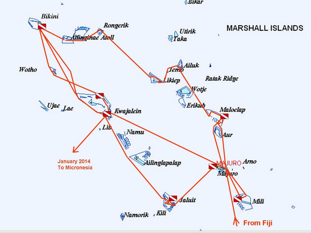
We only spent 32 nights in Majuro Atoll (in 4 visits)--the rest of the time we were out cruising and diving. We used Majuro, and to a lesser extent Kwajalein, as a provisioning and social hub, and that worked our pretty well. You can get provisions, mail, cell phone and internet in both Majuro and Kwaj.
We had easterly winds from May-July and flat dead calm for all of August and September. The locals all said that it was unusual to have had as much wind as we did in June/July, and to have such a prolonged period of no wind in Aug-Sep.
If you've stumbled on our blog and haven't found our Marshall Islands Compendium, you can find it here: http://svsoggypaws.com/files/index.htm#Marshall%20Islands
Saturday, September 28, 2013
Another Easy Passage
We made the final leap of our summer's cruising from Jaluit back to Kwajalein Atoll, where we'll leave Soggy Paws for a few months to go see friends and family in the U.S. This trip was 251 nm, anchor to anchor. And we could have water-skied the entire way, the wind was so calm.
With 5 knots of wind the ENTIRE trip, the passage was exceedingly easy. Most of the time the wind was out of a northern quadrant, so it was essentially "on the nose". We were able to turn off the engine and sail for about 5 hours one night--oh blessed peace. But in flukey winds, on a schedule, it's a lot easier to just pull the sails in tight, crank the engine, and make some miles in the calm conditions. So that's what we did. We may set a record this month for the most engine hours since we left Florida. But, boy, have we seen a lot more of the Marshall Islands that almost everyone--cruisers and locals alike.
The only really memorable part of the trip was that Kwajalein was having "range activity" during the last night, and I happened to look up from my book at just the right time, and saw the missile (?) streaking in to Kwaj. It was kinda cool (but short-lived). The main activity at Kwaj is testing missile defense systems, and they shoot something into the area every couple of months. This is the first one we've seen ourselves.
Because we've been sending in Position Reports via Winlink, we get an advance email from some ham on Kwaj advising us of pending launch activity--the exact coordinates of the closure area, and the times the area is closed. The same notices are posted on shipping channels (Navtex, etc) so the shipping in the area knows about it. Most of the launches are scheduled for late night/early morning, so its not usually a factor in moving around during daylight hours.
We arrived at the South Pass at Kwajalein Atoll about 7am, and motor-sailed an additional 35 miles up to anchor at the north end for a couple of days. The weather is so great for diving, we thought we'd get a couple more dives on the airplane wrecks here, before we head in to put Soggy Paws to bed for awhile. We have a friend from Kwaj Base flying up on the afternoon plane to meet us here and dive with us.
We were amazed to find that the little store here has Romaine Lettuce and Tomatoes, and ice cream, and whole wheat bread. Plus we managed to buy a few gallons of diesel fuel.
On Monday we'll make our way south to Kwaj Base, where we've arranged sponsorship for us for the week we'll be onboard Soggy Paws. We fly out "Space Available" on a military flight on Oct 8, and are scheduled to arrive at Travis AFB (near San Franciso, CA) on Oct 10, after spending one night in Honolulu.
At 09/27/2013 6:39 AM (utc) our position was 09°23.60'N 167°28.29'E
http://svsoggypaws.com/currentposition.htm
With 5 knots of wind the ENTIRE trip, the passage was exceedingly easy. Most of the time the wind was out of a northern quadrant, so it was essentially "on the nose". We were able to turn off the engine and sail for about 5 hours one night--oh blessed peace. But in flukey winds, on a schedule, it's a lot easier to just pull the sails in tight, crank the engine, and make some miles in the calm conditions. So that's what we did. We may set a record this month for the most engine hours since we left Florida. But, boy, have we seen a lot more of the Marshall Islands that almost everyone--cruisers and locals alike.
The only really memorable part of the trip was that Kwajalein was having "range activity" during the last night, and I happened to look up from my book at just the right time, and saw the missile (?) streaking in to Kwaj. It was kinda cool (but short-lived). The main activity at Kwaj is testing missile defense systems, and they shoot something into the area every couple of months. This is the first one we've seen ourselves.
Because we've been sending in Position Reports via Winlink, we get an advance email from some ham on Kwaj advising us of pending launch activity--the exact coordinates of the closure area, and the times the area is closed. The same notices are posted on shipping channels (Navtex, etc) so the shipping in the area knows about it. Most of the launches are scheduled for late night/early morning, so its not usually a factor in moving around during daylight hours.
We arrived at the South Pass at Kwajalein Atoll about 7am, and motor-sailed an additional 35 miles up to anchor at the north end for a couple of days. The weather is so great for diving, we thought we'd get a couple more dives on the airplane wrecks here, before we head in to put Soggy Paws to bed for awhile. We have a friend from Kwaj Base flying up on the afternoon plane to meet us here and dive with us.
We were amazed to find that the little store here has Romaine Lettuce and Tomatoes, and ice cream, and whole wheat bread. Plus we managed to buy a few gallons of diesel fuel.
On Monday we'll make our way south to Kwaj Base, where we've arranged sponsorship for us for the week we'll be onboard Soggy Paws. We fly out "Space Available" on a military flight on Oct 8, and are scheduled to arrive at Travis AFB (near San Franciso, CA) on Oct 10, after spending one night in Honolulu.
At 09/27/2013 6:39 AM (utc) our position was 09°23.60'N 167°28.29'E
http://svsoggypaws.com/currentposition.htm
Thursday, September 26, 2013
Jaluit Atoll
Sep 19-25
We were pleasantly surprised by Jaluit Atoll. We could not find any information from cruisers before us, nor did we have any tracks to follow. And in some places, the Google Earth coverage is not great (too many clouds). So we were kind of "flying blind".
On our quest to find they mayor to do our paperwork, we had a nice walk around Jabor. It is a pleasant, well-kept village, and the people are friendly. There is a small store just inshore from the Fisheries dock (the small concrete dock south of the big pier). There is NTA cell phone coverage and decent wireless internet from NTA.
We met a couple of the American volunteer teachers, sitting in the shade of a tree after school was out. One was from WorldTeach, and one was from Dartmouth's volunteer program. Both had only been in Jaluit for a week or two.
As has been the case all summer, our primary purpose for visiting Jaluit was to see the WWII remains--old buildings, sunken piers, boats, and airplanes. We DID have a nice list of waypoints for dive spots. Can't tell the original source of this list, but it looked like a dive shop dive spot list. It was a pleasant surprise to find that the waypoints were "spot on"--though they indicated the "anchor spot" for the dive, not the actual thing itself. We also had a copy of Henrik Christiansen's Archeological Survey of WWII sites, which we had obtained from the RMI Historical Preservation Office.
From this list, we dove on the following items of interest:
- A "Japanese Tug" in Jabor harbor in about 45 feet. Dave said this was more likely a workboat--it didn't have a big enough prop to be a tug.
- A "German Wreck" near the old Japanese pier in 90 feet. Dave says this is a "composite wreck"--a sailing ship with an iron frame and wooden planking. This was pretty interesting because the iron frame is still there, but the planks were not, so you could easily swim through the entire length of the ship. (Pictures when we get internet.) We didn't see the masts or any rigging, so they may have been traditional materials and rotted away, or maybe stripped before the ship sank. It is late-1800's vintage. Someone told us the ship may have burned before sinking.
- We snorkeled on the old Japanese pier by the airport. This was a really impressive concrete structure, with the end of the pier pilings, about 6 feet in diameter, holding the pier up in about 25-40 feet of water. These had each been made in 2-3 segments, and the segments had collapsed (we assume when the pier was bombed). Another massive Japanese concrete structure. Lots of fish there too. The inner end of the pier is just rubble.
- We snorkeled the "Japanese Ship" on the way to Imeij. This ship looks like it was run straight up on shore (probably when sinking, maybe as a result of U.S. bombing). Christiansen's report didn't talk about this at all, so we don't know anything about it.
- We did a "jungle stomp" and found the old Japanese radio facility. This is now in an uninhabited part of the atoll, south of Imeij. It is totally invisible from the water--we had been told that it was "300 meters north of the ship". We saw some likely spots on Google Earth, but they turned out to be swampy areas, and were too far north. It took a little wandering around, but we finally stumbled on the wreckage of the radio towers, by walking the jungle along the shoreline back south toward the ship. From there we could see the impressive 3 story building--now completely wrecked (but still a fun scramble). If you know what you're looking for, you can spot it from the anchorage north of the ship--look for the tallest Pandanus tree on the the skyline (it's growing on the roof of the building). There are no paths, you just have to whack your way in.
Next we moved to Imeij, where we had waypoints for the two Japanese Kawanishi "Emily" flying boats. These are huge (100' long with a 150' wingspan) flying boats. They were bombed and sunk at anchor off the concrete ramps at Imeij. One is nearly intact, but upside down, in 90 feet. The other is broken up a bit, in 60 feet. Probably the best airplane wrecks we've seen this summer.
Then we went ashore a Imeij, trying to find the airplane hangars--one of which is supposed to have another Emily inside. After walking up and down the main path in the village, peering into the jungle, we finally asked someone where they were. We finally found someone interested in showing us--all that remains of the hangars are the concrete pad and some rusting beams on the ground. The "Emily" airplane is just scraps and would be pretty unrecognizable if we didn't already know what it was.
On a whim, we took off on our own from there, following a jungle path toward the east side of the island. We were pleasantly surprised to stumble on at least 3 more large concrete buildings. Each made out of concrete 2-3 feet thick, with heavy iron doors and windows. One had almost no windows, and even thicker concrete--probably a munitions storage (but was a building, not a bunker). Unlike a few other locations we've seen, all these buildings were mostly stripped of their contents. A few of the small buildings near the shore had been converted by the locals to housing and/or storage. We only saw one "gun"--on the beach near the church.
The next day, we took off across the atoll toward the west, to try to find the Devastator airplanes. We had the waypoint for one in 50 feet and a verbal description of the more pristine one in 120 feet. We found the shallower one easily and took a lot of pictures. But our attempt to find the deeper one failed. We were going to make a second dive to try to find the deep one, but the weather turned bad and we skedaddled out of the unprotected location. We had hopes of returning a day or so later, but the weather stayed very unsettled for several days. We ended up sitting in Jabor enjoying the fairly decent internet (NTA Wifi) and watching the last America's Cup race recaps on YouTube (where the Americans came from an 8-1 deficit to beat the Kiwis for a 9-8 American win). Exciting stuff. (On our passage to Kwajalein in 5 knots of wind, we kept asking each other "Are we foiling yet?")
We covered a lot of ground in 6 days! Again, we could have easily spent another couple of weeks in Jaluit, getting to know the people and the villages better, and also exploring the remoter parts of the atoll. However, we're on a mission to get to Kwajalien by Oct 1, so we had to hurry off again.
We were pleasantly surprised by Jaluit Atoll. We could not find any information from cruisers before us, nor did we have any tracks to follow. And in some places, the Google Earth coverage is not great (too many clouds). So we were kind of "flying blind".
On our quest to find they mayor to do our paperwork, we had a nice walk around Jabor. It is a pleasant, well-kept village, and the people are friendly. There is a small store just inshore from the Fisheries dock (the small concrete dock south of the big pier). There is NTA cell phone coverage and decent wireless internet from NTA.
We met a couple of the American volunteer teachers, sitting in the shade of a tree after school was out. One was from WorldTeach, and one was from Dartmouth's volunteer program. Both had only been in Jaluit for a week or two.
As has been the case all summer, our primary purpose for visiting Jaluit was to see the WWII remains--old buildings, sunken piers, boats, and airplanes. We DID have a nice list of waypoints for dive spots. Can't tell the original source of this list, but it looked like a dive shop dive spot list. It was a pleasant surprise to find that the waypoints were "spot on"--though they indicated the "anchor spot" for the dive, not the actual thing itself. We also had a copy of Henrik Christiansen's Archeological Survey of WWII sites, which we had obtained from the RMI Historical Preservation Office.
From this list, we dove on the following items of interest:
- A "Japanese Tug" in Jabor harbor in about 45 feet. Dave said this was more likely a workboat--it didn't have a big enough prop to be a tug.
- A "German Wreck" near the old Japanese pier in 90 feet. Dave says this is a "composite wreck"--a sailing ship with an iron frame and wooden planking. This was pretty interesting because the iron frame is still there, but the planks were not, so you could easily swim through the entire length of the ship. (Pictures when we get internet.) We didn't see the masts or any rigging, so they may have been traditional materials and rotted away, or maybe stripped before the ship sank. It is late-1800's vintage. Someone told us the ship may have burned before sinking.
- We snorkeled on the old Japanese pier by the airport. This was a really impressive concrete structure, with the end of the pier pilings, about 6 feet in diameter, holding the pier up in about 25-40 feet of water. These had each been made in 2-3 segments, and the segments had collapsed (we assume when the pier was bombed). Another massive Japanese concrete structure. Lots of fish there too. The inner end of the pier is just rubble.
- We snorkeled the "Japanese Ship" on the way to Imeij. This ship looks like it was run straight up on shore (probably when sinking, maybe as a result of U.S. bombing). Christiansen's report didn't talk about this at all, so we don't know anything about it.
- We did a "jungle stomp" and found the old Japanese radio facility. This is now in an uninhabited part of the atoll, south of Imeij. It is totally invisible from the water--we had been told that it was "300 meters north of the ship". We saw some likely spots on Google Earth, but they turned out to be swampy areas, and were too far north. It took a little wandering around, but we finally stumbled on the wreckage of the radio towers, by walking the jungle along the shoreline back south toward the ship. From there we could see the impressive 3 story building--now completely wrecked (but still a fun scramble). If you know what you're looking for, you can spot it from the anchorage north of the ship--look for the tallest Pandanus tree on the the skyline (it's growing on the roof of the building). There are no paths, you just have to whack your way in.
Next we moved to Imeij, where we had waypoints for the two Japanese Kawanishi "Emily" flying boats. These are huge (100' long with a 150' wingspan) flying boats. They were bombed and sunk at anchor off the concrete ramps at Imeij. One is nearly intact, but upside down, in 90 feet. The other is broken up a bit, in 60 feet. Probably the best airplane wrecks we've seen this summer.
Then we went ashore a Imeij, trying to find the airplane hangars--one of which is supposed to have another Emily inside. After walking up and down the main path in the village, peering into the jungle, we finally asked someone where they were. We finally found someone interested in showing us--all that remains of the hangars are the concrete pad and some rusting beams on the ground. The "Emily" airplane is just scraps and would be pretty unrecognizable if we didn't already know what it was.
On a whim, we took off on our own from there, following a jungle path toward the east side of the island. We were pleasantly surprised to stumble on at least 3 more large concrete buildings. Each made out of concrete 2-3 feet thick, with heavy iron doors and windows. One had almost no windows, and even thicker concrete--probably a munitions storage (but was a building, not a bunker). Unlike a few other locations we've seen, all these buildings were mostly stripped of their contents. A few of the small buildings near the shore had been converted by the locals to housing and/or storage. We only saw one "gun"--on the beach near the church.
The next day, we took off across the atoll toward the west, to try to find the Devastator airplanes. We had the waypoint for one in 50 feet and a verbal description of the more pristine one in 120 feet. We found the shallower one easily and took a lot of pictures. But our attempt to find the deeper one failed. We were going to make a second dive to try to find the deep one, but the weather turned bad and we skedaddled out of the unprotected location. We had hopes of returning a day or so later, but the weather stayed very unsettled for several days. We ended up sitting in Jabor enjoying the fairly decent internet (NTA Wifi) and watching the last America's Cup race recaps on YouTube (where the Americans came from an 8-1 deficit to beat the Kiwis for a 9-8 American win). Exciting stuff. (On our passage to Kwajalein in 5 knots of wind, we kept asking each other "Are we foiling yet?")
We covered a lot of ground in 6 days! Again, we could have easily spent another couple of weeks in Jaluit, getting to know the people and the villages better, and also exploring the remoter parts of the atoll. However, we're on a mission to get to Kwajalien by Oct 1, so we had to hurry off again.
Passage from Majuro to Jaluit Atoll
Sep 18-19, 2013
Jaluit is only 120 miles SW of Majuro, but the fact that Majuro's only channel faces east, and Majuro town is at the far SE end of the atoll adds about 20-30 miles to the trip. But it was still only a single overnight to get there. As has been the case for the last 2 months, there was virtually no wind, so we motorsailed pretty much the whole way. When there was wind, it was 5-10 knots out of the NE, dead behind us, so not much good. We had a full moon, and without those pesky sails to mess with, it was a very easy passage in calm weather.
Though we had a lot of success fishing in Fiji, we have been almost completely skunked here in the Marshall Islands. It's not that there aren't fish here, because we know the sportfish boats in Majuro catch a lot of fish. I think Dave has just made one too many adjustments in his fishing tackle. We've also had a pretty full freezer, and so have not been as motivated as we could be to fish. I think I still have a Fiji "Walu" in the bottom of the freezer from February, and nice sashimi-grade tuna is pretty cheap in Majuro. Plus, of course, the light winds mean we've been motoring at around 5 knots most of the time--too slow for the fish we like to catch.
We arrived at the Southeast Pass at Jaluit (the pass nearest Jabor) around 2pm. Though we had a high overcast, we had good enough Google Earth charts and decent light, so it was an easy entry in calm weather. The current rips in an out of this pass. It was behind us coming in and we had about 2 knots of current at the peak. Since this pass faces NE, I would be a little leery of coming in this pass with a strong northeasterly and a falling tide. It would definitely be ugly. There is a SW pass that might be better in a strong NE wind. The midpoint of the SE pass is 05-55.62N / 169-38.40E
Charting: Like the rest of the Marshall Islands our Garmin (old) charts have no detail and are pretty useless. The CMAP CM93 charts from 2009/2010 are pretty detailed, but off a bit. I have been carefully using the Google Earth charts and OpenCPN and re-reference the CMAP charts (keeping a list which will go in the Marshalls Compendium). Once I get a detailed chart nudged a bit to line up with the Google Earth, then they are pretty damned good for navigating with. But I have found that sometimes when you get the GE/CMAP lined up in one place, it's out in another (on the same chart). So you have to be pretty careful. And of course, always use your "Mark I Eyeballs". But it's nice to know where we should be paying extra attention.
Most of the time, the Marshall Islands atolls are deep deep deep in the middle. But there are always scattered "bommies" that shoot up out of 150 feet to 2 feet, and then back down. The 2-footers are easy to spot. It's spotting the 5-7 footers that are sometimes the problem. But more of a problem is finding a shallow spot to anchor. The Google Earth charts are really invaluable here, as they can help you find those sand spots that look coral-free and not too deep and not to shallow.
Anyway, we came in the pass, made a left hook around to the Jabor anchorage, and dropped anchor off the big Jabor pier in about 45 feet mixed sand and coral. Our Anchor Spot: 05-55.15N / 169-38.48E If you go any further south than this, the water gets shallower, but there are tons of coral heads. You want to stay south of the pier, however, as there is a sunken tug directly off and slightly north of the pier, at 05-55.18N / 169.38.45E
It took us 2 tries ashore to find the mayor, to show our paperwork and pay our fee. But that was a pleasurable experience, as the major, Billa, a 50-ish woman, spoke excellent English and was very savvy. I think this is the very first time we actually met the mayor of an atoll--everywhere else we've been, the mayor has been in Majuro, and we dealt with an "acting mayor" who is usually not as good at English and not very "plugged in" to visiting yachties.
Jaluit is only 120 miles SW of Majuro, but the fact that Majuro's only channel faces east, and Majuro town is at the far SE end of the atoll adds about 20-30 miles to the trip. But it was still only a single overnight to get there. As has been the case for the last 2 months, there was virtually no wind, so we motorsailed pretty much the whole way. When there was wind, it was 5-10 knots out of the NE, dead behind us, so not much good. We had a full moon, and without those pesky sails to mess with, it was a very easy passage in calm weather.
Though we had a lot of success fishing in Fiji, we have been almost completely skunked here in the Marshall Islands. It's not that there aren't fish here, because we know the sportfish boats in Majuro catch a lot of fish. I think Dave has just made one too many adjustments in his fishing tackle. We've also had a pretty full freezer, and so have not been as motivated as we could be to fish. I think I still have a Fiji "Walu" in the bottom of the freezer from February, and nice sashimi-grade tuna is pretty cheap in Majuro. Plus, of course, the light winds mean we've been motoring at around 5 knots most of the time--too slow for the fish we like to catch.
We arrived at the Southeast Pass at Jaluit (the pass nearest Jabor) around 2pm. Though we had a high overcast, we had good enough Google Earth charts and decent light, so it was an easy entry in calm weather. The current rips in an out of this pass. It was behind us coming in and we had about 2 knots of current at the peak. Since this pass faces NE, I would be a little leery of coming in this pass with a strong northeasterly and a falling tide. It would definitely be ugly. There is a SW pass that might be better in a strong NE wind. The midpoint of the SE pass is 05-55.62N / 169-38.40E
Charting: Like the rest of the Marshall Islands our Garmin (old) charts have no detail and are pretty useless. The CMAP CM93 charts from 2009/2010 are pretty detailed, but off a bit. I have been carefully using the Google Earth charts and OpenCPN and re-reference the CMAP charts (keeping a list which will go in the Marshalls Compendium). Once I get a detailed chart nudged a bit to line up with the Google Earth, then they are pretty damned good for navigating with. But I have found that sometimes when you get the GE/CMAP lined up in one place, it's out in another (on the same chart). So you have to be pretty careful. And of course, always use your "Mark I Eyeballs". But it's nice to know where we should be paying extra attention.
Most of the time, the Marshall Islands atolls are deep deep deep in the middle. But there are always scattered "bommies" that shoot up out of 150 feet to 2 feet, and then back down. The 2-footers are easy to spot. It's spotting the 5-7 footers that are sometimes the problem. But more of a problem is finding a shallow spot to anchor. The Google Earth charts are really invaluable here, as they can help you find those sand spots that look coral-free and not too deep and not to shallow.
Anyway, we came in the pass, made a left hook around to the Jabor anchorage, and dropped anchor off the big Jabor pier in about 45 feet mixed sand and coral. Our Anchor Spot: 05-55.15N / 169-38.48E If you go any further south than this, the water gets shallower, but there are tons of coral heads. You want to stay south of the pier, however, as there is a sunken tug directly off and slightly north of the pier, at 05-55.18N / 169.38.45E
It took us 2 tries ashore to find the mayor, to show our paperwork and pay our fee. But that was a pleasurable experience, as the major, Billa, a 50-ish woman, spoke excellent English and was very savvy. I think this is the very first time we actually met the mayor of an atoll--everywhere else we've been, the mayor has been in Majuro, and we dealt with an "acting mayor" who is usually not as good at English and not very "plugged in" to visiting yachties.
Sunday, September 15, 2013
Maloelap Corsair Search
We had a nice week in Maloelap. We spent most of the time around Taroa, where the Japanese had a major air base during World War II. The first thing that impressed us, was that the Japanese built their installations as if they were there to stay for a long time. This was no fly-by-night forward base. The concrete pier is massive and built of thick reinforced concrete. They built a massive generator facility on another small island a couple of miles away, and ran heavy-duty electrical cable between the two islands. If you're interested, check out this short tourist overview of the Japanese facilities:
A Virtual Tour of Taroa Airbase
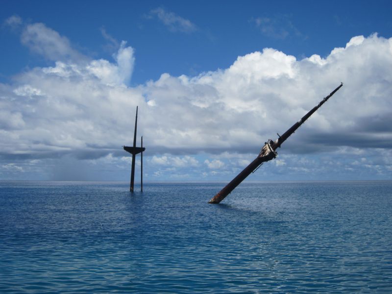
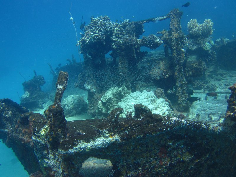
We knew there was a Japanese ship sunk in the bay--it's the first thing you notice as you pull in to the island--the ship lies in about 40 feet of water, and it's tall masts (for lifting cargo) stick 20-30 feet out of the water. We eventually did 2 dives on this ship.

The Masts of the Sunken Japanese Wreck, Tarushima Maru
But the focus for our visit to Taroa was to search for the "missing" Corsair. The F4U Corsair were the primary USN fighters during World War II, and one was supposed to have been shot down over Taroa, landing in the water just off the pier.
Our instructions from Matt Holly were to search "north of the pier and out beyond 60 feet". But in reading the past archaeological studies of the WWII stuff in Taroa, we saw that the University of Hawaii had done a magnetometer survey in the area off the pier, found some "hits", but had never gone and investigated them. So (geek that I am) I snatched the rough graphic of the search area out of the study PDF file, sucked it in to SeaClear (a charting program that you can use to create your own charts), used a couple of landmarks (the pier, the ship, and N and S points of the island) to "geo-reference" the magnetometer search area onto a chart. Then we took waypoints off of the two major anomalies that were in our search area, and went directly there to investigate them.

The Output of the University of Hawaii
Magnetometer Survey of Taroa in 1999
Red dots are the two uninvestigated magnetic anomalies
that we checked out
I was amazed that we found something in both places! (ie my hairbrained idea wasn't so hairbrained). But, alas, they were definitely not "airplane debris". The #10 anomaly was a coil of what we think was the heavy generator cable, and the #8 anomaly was maybe ship debris, or something off the pier.

The Debris We Found at the #8 Magnetometer Anomaly
What it did do was validate the now-georeferenced magnetometer survey. It also gave us a feel for the diving conditions. #10 was in about 100 feet of water and #8 was in about 60-70 feet of water. From the dinghy, with days of calm conditions behind us, in 60-70 feet of water, we could clearly make out shapes on the bottom in the sand. So we knew it would be feasible to tow behind the dinghy with a snorkeler and do a systematic search--at least until the water got too deep to see the bottom from the surface.
So I figured out how to use OpenCPN's Search and Rescue plug-in to have it lay out an organized search pattern in a "box" shape, with lanes 60 feet apart. We downloaded this as a route to our hand-held Garmin GPS, and set out to do a systematic search. The Garmin laid a "snail trail" showing where we went, and we then uploaded this back into the computer to keep a record of where we searched.

Our Corsair Search off Taroa Island
The pinkish lines are our actual search path
The magnetometer survey is outlined with light blue arrows.
The westernmost dive flag is where the #10 anomaly was, in 100'
We laid out our search pattern to parallel the shore, so that we (hopefully) had even depths. We started in about 60 feet of water, and ended up in 80-90 feet of water. Unfortunately, the amazingly clear conditions did not stay with us. After the 3rd day, the visibility went down to 30 feet or less. And by then we were out in pretty deep water. Even snorkeling down to 20-30 feet (while being towed behind the dinghy at 2 knots), it was difficult to distinguish features on the bottom. We'd have to use SCUBA and be towed at about 60 feet to see anything on the bottom.
Dave made a 'diving plane' out of plywood that helped us control our depth--this worked well when snorkeling, to allow the towed person to dive deeper as he was being towed. (We forgot to take a picture of it, but here's a YouTube Video from someone else. Ours is just an 14" x 24" board). This would also be useful if we had to resort to SCUBA. But we kept hoping the viz would improve so we could continue searching further out--out beyond the magnetometer survey borders. But it never did, even though the winds stayed calm. We suspect that the better-than-normal visibility we had when we first arrived may have been due to the fact that the tidal range went down to only about a foot. Normally the tidal range is 4-5 feet.
Jerry on Challenger was there with us the whole time, and helped us with the search. Dave and I and Jerry took turns, with one person being towed, one person driving the dinghy (watching the GPS very closely to stay in the "lane"), and the 3rd person checking depths and watching the person in the water.
While we were waiting for our friends on Westward II to show up, we took Soggy Paws and Challenger 5 miles north to check out Pigeeyatto (aka Bigat or Pigget) and Ollot islands. Pigeeyatto was where the generator facility was, and Ollot had a couple of sunken small Japanese freighters, and the remains of two Japaneze Zero airplanes.
The locals claim that one of the two sunken ships at Ollot was the ship that transported Louis Zamperini to Kwajalein. Zamperini is the downed US pilot who drifted in a liferaft for 46 days, only to drift into Japanese hands at Maloelap or Wotje (they're not sure which). He spent the rest of the war trying to survive in Japanese prisons in the islands and on mainland Japan. (see Unbroken: A World War II Story of Survival, Resilience, and Redemption for this amazing story).

The Wreck of the Ship that Transported Zamperini to Kwajelein

Japanese Zero Wreckage on the Reef Near Ollot

Ollot Kids Who Came Out to See What We Were Looking At

An Old Canoe Ashore at Pigeeyatto

The Huge Generator Building at Pigeeyatto

A Sailboat Wreck on Pigeeyatto
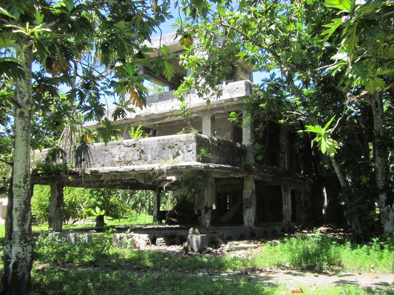
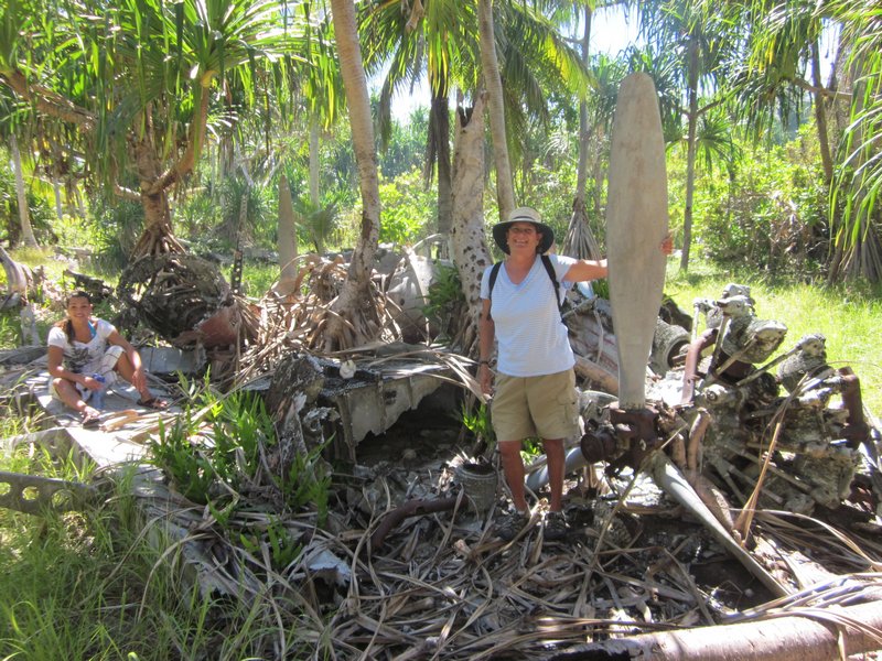
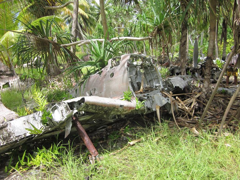
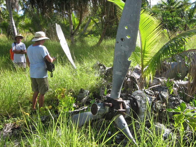
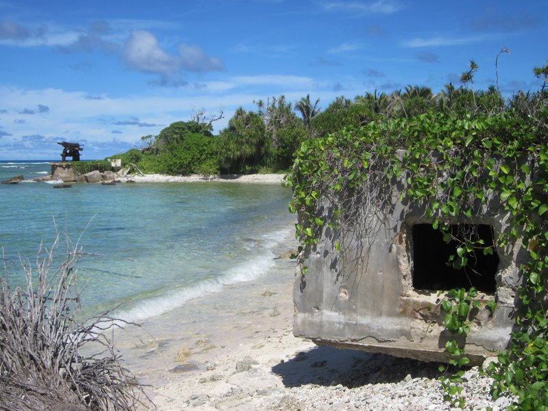
We also spent two afternoons tromping through the bush on Taroa looking at the extensive WWII debris--the remains of airplanes (bombed by American forces while on the ground), gun emplacements, runways, and buildings.

The Bombed-Out Japanese Command Center on Taroa

The Airplane Graveyard at Taroa

The Airplane Graveyard at Taroa

Note Bullet Holes in the Propeller!

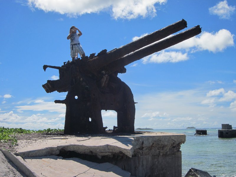
Anti-Aircraft Guns on the Beach

Ulyana on a 127 mm Gun Emplacement

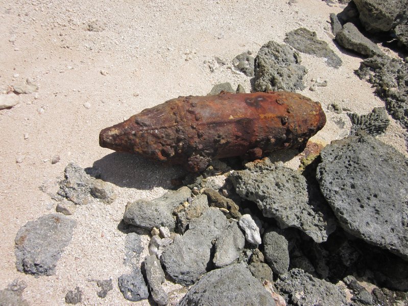
Old Unexploded Bombs are Still All Over the Place

These Old Bombs Have Been Cleared
by an Unexploded Ordnance Squad

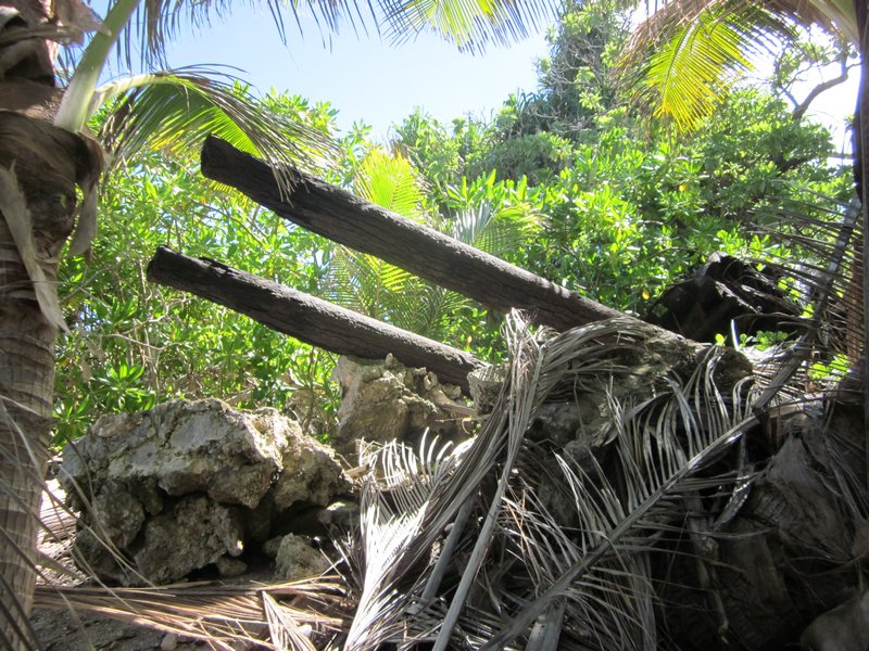
Lots More Stuff Hard to Find in the Jungle

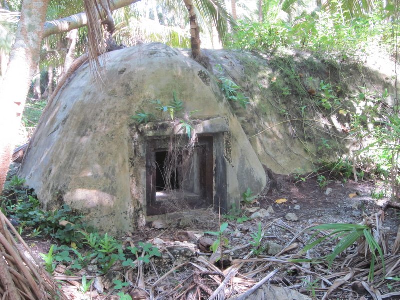
An Ordnance Bunker?

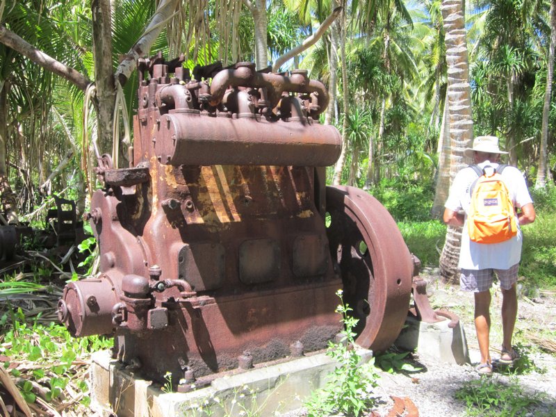
Circa 1940 Yanmar Generator

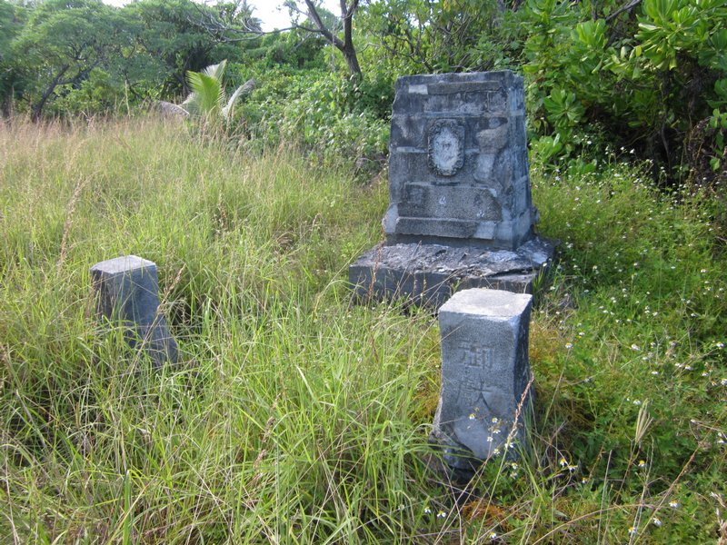
A Memorial Erected by the Japanese to their Lost Soldiers
We never really did engage with the people of Maloelap on this trip. We were too busy in our "seeing WWII artifacts" mission. The people who live here don't really give a rat's ass about the "artifacts". They don't really understand the benefits of tourism, and the debris just gets in the way of farming the land. And of course it brings in these odd people who want to look at 70-year old war debris.
And we never did find the Corsair--but we did expand the area that we know where it's NOT. We handed over our search information to Matt Holly and the Marshall Islands Historical Preservation Office, so next group of interested people can pick up where we left off.
We are on a mission to fit in one more atoll (Jaluit) before we have to head to Kwajalein and park Soggy Paws for our annual trip back to the U.S. So we hurried off back to Majuro to reprovision, leaving Challenger and Westward II in Maloelap. They moved south to Airik Island (still in Maloelap Atoll), and spent a few days there "fixing things" for the locals. On the list: hooking up replacement batteries to their hospital solar system, diagnosing solar controller problems, fixing a chainsaw, looking at a strange VHF radio problem, and tinkering with a couple of outboard motor issues. In return, they were amply rewarded with local produce--papayas and limes, and lobster.
We are now back in Majuro, getting ready to head to Jaluit, another Japanese base in WWII, and then on to Kwajalein. We are scheduled to fly out to the U.S. on October 8, from Kwajalein.
A Virtual Tour of Taroa Airbase
We knew there was a Japanese ship sunk in the bay--it's the first thing you notice as you pull in to the island--the ship lies in about 40 feet of water, and it's tall masts (for lifting cargo) stick 20-30 feet out of the water. We eventually did 2 dives on this ship.
But the focus for our visit to Taroa was to search for the "missing" Corsair. The F4U Corsair were the primary USN fighters during World War II, and one was supposed to have been shot down over Taroa, landing in the water just off the pier.
Our instructions from Matt Holly were to search "north of the pier and out beyond 60 feet". But in reading the past archaeological studies of the WWII stuff in Taroa, we saw that the University of Hawaii had done a magnetometer survey in the area off the pier, found some "hits", but had never gone and investigated them. So (geek that I am) I snatched the rough graphic of the search area out of the study PDF file, sucked it in to SeaClear (a charting program that you can use to create your own charts), used a couple of landmarks (the pier, the ship, and N and S points of the island) to "geo-reference" the magnetometer search area onto a chart. Then we took waypoints off of the two major anomalies that were in our search area, and went directly there to investigate them.
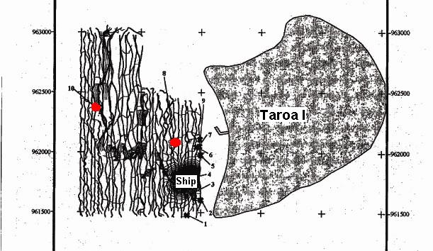
Magnetometer Survey of Taroa in 1999
Red dots are the two uninvestigated magnetic anomalies
that we checked out
I was amazed that we found something in both places! (ie my hairbrained idea wasn't so hairbrained). But, alas, they were definitely not "airplane debris". The #10 anomaly was a coil of what we think was the heavy generator cable, and the #8 anomaly was maybe ship debris, or something off the pier.
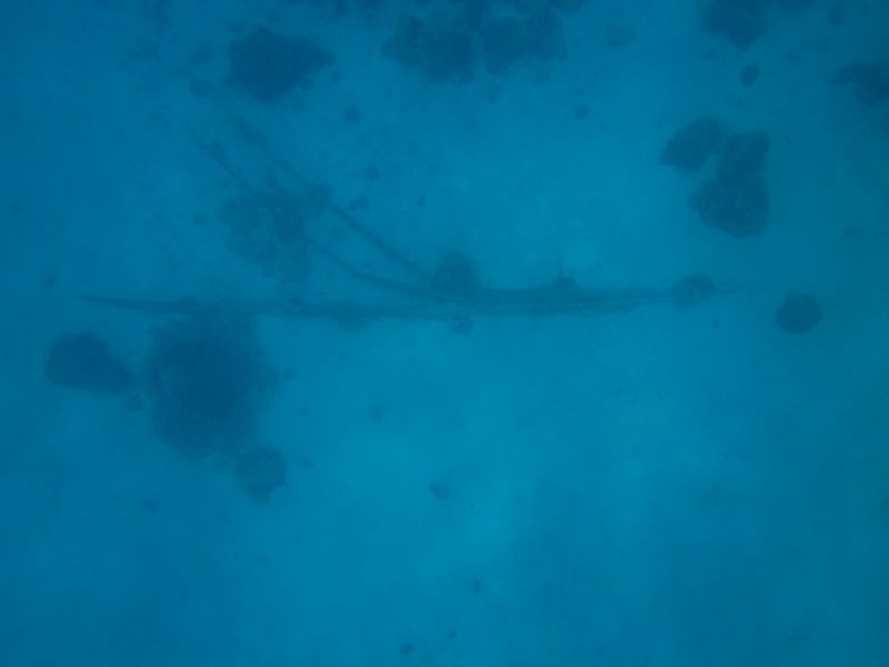
What it did do was validate the now-georeferenced magnetometer survey. It also gave us a feel for the diving conditions. #10 was in about 100 feet of water and #8 was in about 60-70 feet of water. From the dinghy, with days of calm conditions behind us, in 60-70 feet of water, we could clearly make out shapes on the bottom in the sand. So we knew it would be feasible to tow behind the dinghy with a snorkeler and do a systematic search--at least until the water got too deep to see the bottom from the surface.
So I figured out how to use OpenCPN's Search and Rescue plug-in to have it lay out an organized search pattern in a "box" shape, with lanes 60 feet apart. We downloaded this as a route to our hand-held Garmin GPS, and set out to do a systematic search. The Garmin laid a "snail trail" showing where we went, and we then uploaded this back into the computer to keep a record of where we searched.
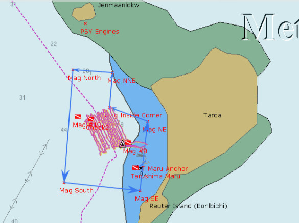
The pinkish lines are our actual search path
The magnetometer survey is outlined with light blue arrows.
The westernmost dive flag is where the #10 anomaly was, in 100'
We laid out our search pattern to parallel the shore, so that we (hopefully) had even depths. We started in about 60 feet of water, and ended up in 80-90 feet of water. Unfortunately, the amazingly clear conditions did not stay with us. After the 3rd day, the visibility went down to 30 feet or less. And by then we were out in pretty deep water. Even snorkeling down to 20-30 feet (while being towed behind the dinghy at 2 knots), it was difficult to distinguish features on the bottom. We'd have to use SCUBA and be towed at about 60 feet to see anything on the bottom.
Dave made a 'diving plane' out of plywood that helped us control our depth--this worked well when snorkeling, to allow the towed person to dive deeper as he was being towed. (We forgot to take a picture of it, but here's a YouTube Video from someone else. Ours is just an 14" x 24" board). This would also be useful if we had to resort to SCUBA. But we kept hoping the viz would improve so we could continue searching further out--out beyond the magnetometer survey borders. But it never did, even though the winds stayed calm. We suspect that the better-than-normal visibility we had when we first arrived may have been due to the fact that the tidal range went down to only about a foot. Normally the tidal range is 4-5 feet.
Jerry on Challenger was there with us the whole time, and helped us with the search. Dave and I and Jerry took turns, with one person being towed, one person driving the dinghy (watching the GPS very closely to stay in the "lane"), and the 3rd person checking depths and watching the person in the water.
While we were waiting for our friends on Westward II to show up, we took Soggy Paws and Challenger 5 miles north to check out Pigeeyatto (aka Bigat or Pigget) and Ollot islands. Pigeeyatto was where the generator facility was, and Ollot had a couple of sunken small Japanese freighters, and the remains of two Japaneze Zero airplanes.
The locals claim that one of the two sunken ships at Ollot was the ship that transported Louis Zamperini to Kwajalein. Zamperini is the downed US pilot who drifted in a liferaft for 46 days, only to drift into Japanese hands at Maloelap or Wotje (they're not sure which). He spent the rest of the war trying to survive in Japanese prisons in the islands and on mainland Japan. (see Unbroken: A World War II Story of Survival, Resilience, and Redemption for this amazing story).
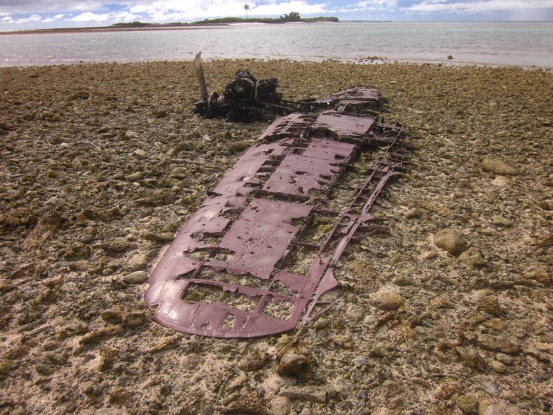
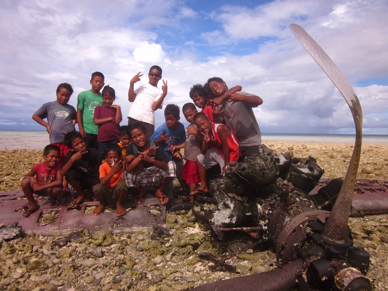
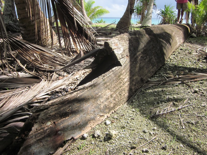
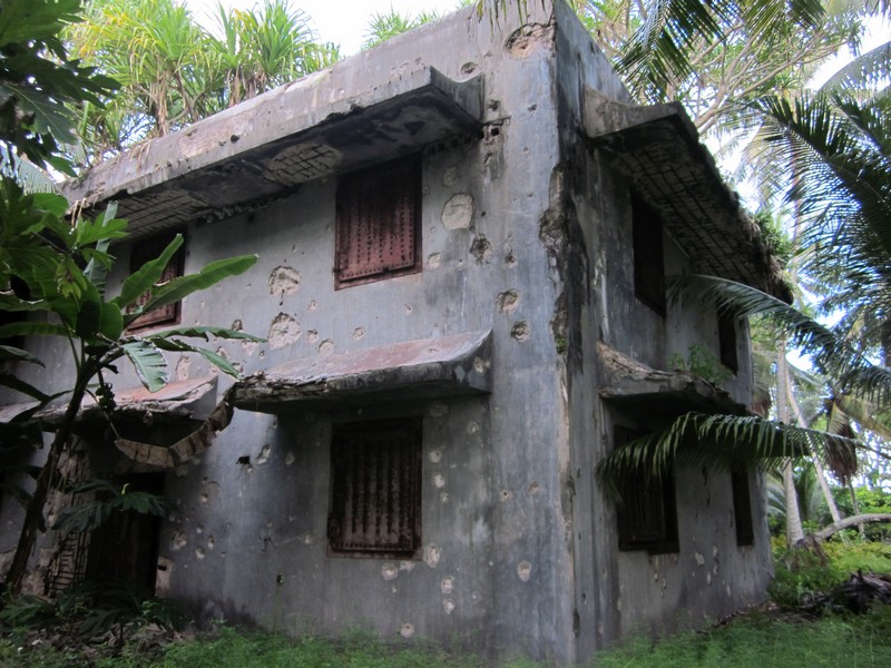
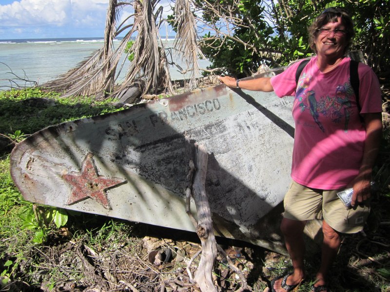
We also spent two afternoons tromping through the bush on Taroa looking at the extensive WWII debris--the remains of airplanes (bombed by American forces while on the ground), gun emplacements, runways, and buildings.
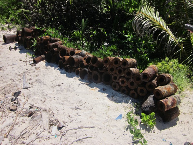
by an Unexploded Ordnance Squad
We never really did engage with the people of Maloelap on this trip. We were too busy in our "seeing WWII artifacts" mission. The people who live here don't really give a rat's ass about the "artifacts". They don't really understand the benefits of tourism, and the debris just gets in the way of farming the land. And of course it brings in these odd people who want to look at 70-year old war debris.
And we never did find the Corsair--but we did expand the area that we know where it's NOT. We handed over our search information to Matt Holly and the Marshall Islands Historical Preservation Office, so next group of interested people can pick up where we left off.
We are on a mission to fit in one more atoll (Jaluit) before we have to head to Kwajalein and park Soggy Paws for our annual trip back to the U.S. So we hurried off back to Majuro to reprovision, leaving Challenger and Westward II in Maloelap. They moved south to Airik Island (still in Maloelap Atoll), and spent a few days there "fixing things" for the locals. On the list: hooking up replacement batteries to their hospital solar system, diagnosing solar controller problems, fixing a chainsaw, looking at a strange VHF radio problem, and tinkering with a couple of outboard motor issues. In return, they were amply rewarded with local produce--papayas and limes, and lobster.
We are now back in Majuro, getting ready to head to Jaluit, another Japanese base in WWII, and then on to Kwajalein. We are scheduled to fly out to the U.S. on October 8, from Kwajalein.
Subscribe to:
Posts (Atom)